John Sheldon House, Deerfield, Massachusetts

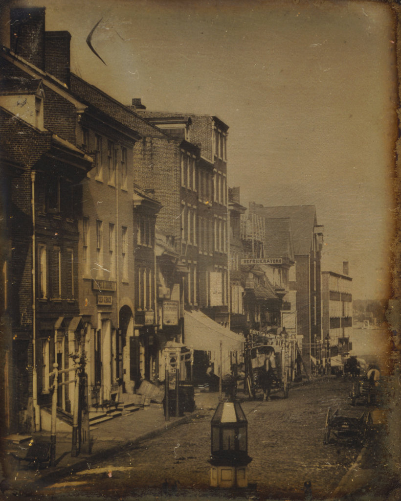
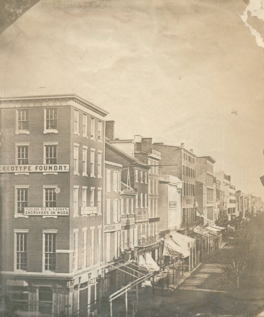
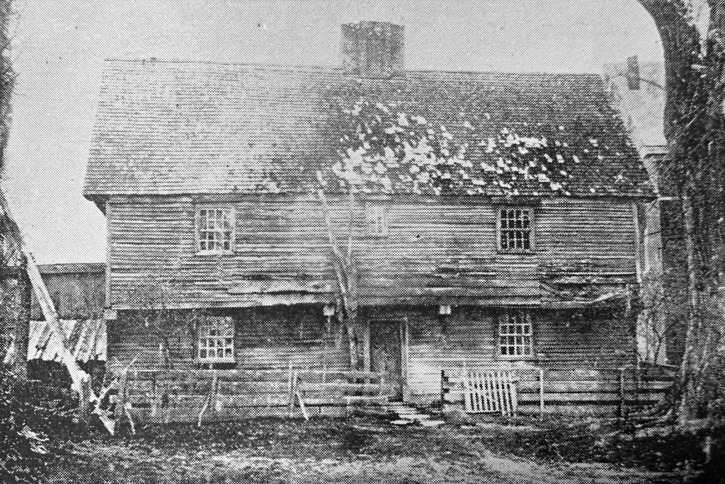
The John Sheldon House, also known as the “Old Indian House,” in Deerfield, Massachusetts, around 1848. Image from Picturesque Franklin (1891).
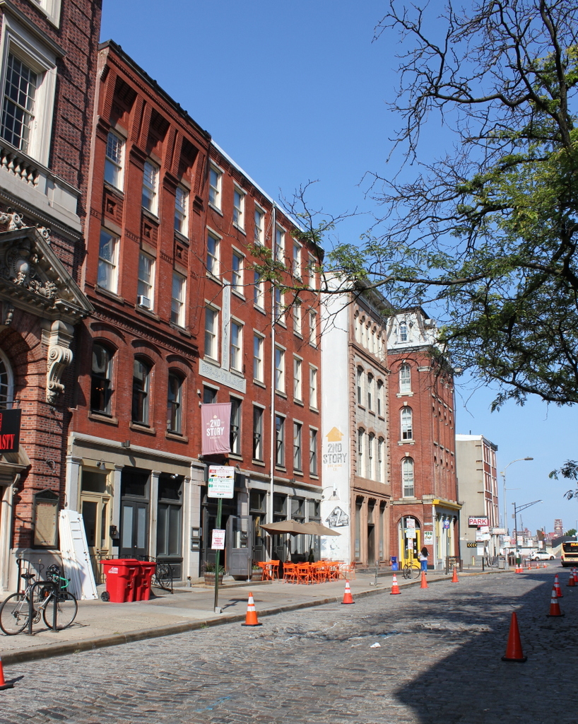
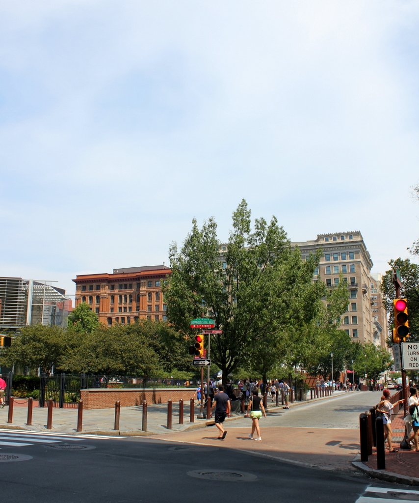
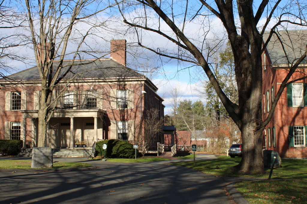
The scene in 2023:

Deerfield features one of the best-preserved colonial town centers in New England, with a number of 18th century homes lining its historic Old Main Street. However, perhaps its single most famous landmark is a house that has been gone for the past 175 years. Known variously as the John Sheldon House or the Old Indian House, it was built around 1696 and stood here on the west side of Old Main Street until it was demolished in 1848. The top photo was taken shortly before its demolition, making it a very early example of an architectural photograph.

When it was built, the house was the largest in town. The original portion of the house measured 42 feet by 21 feet, and it consisted of two rooms on the first floor, two on the second floor, and a garret space in the attic. In the center of the house was a large chimney, which measured ten feet on each side on the first floor. Later in the 18th century, a kitchen lean-to was added to the back of the house, creating a saltbox-style appearance.

This was a common layout that was used in New England houses well into the mid-18th century, but it also had some architectural features that indicated its 17th century origins. It had a very steep roof, which was often seen on First Period homes, and it also appears to have had a fairly ornate chimney, in contrast to the more plain chimneys found on 18th century homes. Perhaps the most distinctive clues to its age were the overhanging second story on the front façade and the overhanging end gables on the sides of the house. These types of overhangs were common on 17th century homes, and were holdovers from post-medieval architecture in England.

Although the house was architecturally significant as a particularly elaborate First Period home in the Connecticut River Valley, it is best remembered for its role in the 1704 raid on Deerfield. The raid occurred during Queen Anne’s War, which was known in Europe as the War of Spanish Succession. The conflict began in Europe following the death of Charles II of Spain, the famously-inbred Hapsburg monarch who died without any heirs. Louis XIV of France claimed his grandson as the rightful heir to the Spanish throne, but this prompted England to go to war with France and Spain, in order to avoid shifting the balance of power in Europe. And, as was often the case in the 18th century, the conflict spilled over into the Americas, where French and English colonists fought for territorial control.

At the time, Deerfield was the northernmost major English settlement in the Connecticut River Valley, which left it vulnerable to French incursions. During the early morning hours of February 29, 1704, the town was attacked by a force of about 48 French soldiers and 240 Abenaki and other Native American warriors. The raiders went from house to house, killing or capturing as many of the inhabitants as possible, while also burning many of the homes.

Here at the Sheldon house, John Sheldon was evidently not home at the time, but the rest of his family was. The raiders had difficulty getting into the house due to the strength of the front door, but they used their axes to chop small holes in the door, which enabled them to shoot into the house. One of the bullets struck and killed John’s wife, Hannah.

The raiders were eventually able to gain access through the back door of the house. John’s son, who was also named John, was upstairs with his newlywed wife Hannah. They jumped out the window, intending to flee to Hatfield, but Hannah sprained her ankle in the fall. She was eventually captured, but she urged John to continue to Hatfield to get help for the town.

Aside from Hannah, several other members of the Sheldon family were captured, including 16-year-old Mary, 12-year-old Ebenezer, and 11-year-old Remembrance. The youngest Sheldon sibling, 2-year-old Mercy, was killed during the raid, supposedly from having her head beaten on the doorstep of the house.

In total, there were 291 Deerfield residents here in the village at the time of the raid. Of those, 56 were killed and 112 were captured. Nearly half of the houses in town were burned, but the Sheldon house survived. The house was temporarily used as a holding site for the captives before they were marched northward to Canada.

Some of the captives were killed during the march, and many of the young children were adopted into Native American families and chose not to return to the English colonies. However, All four of the Sheldon captives survived the march, and over the next few years John Sheldon made several trips to Canada to negotiate their release. All four were back here in Deerfield by 1706.

This house would remain in the Sheldon family for many years, with Ebenezer eventually acquiring it from his father. He lived here until 1744, when he sold the house to Jonathan Hoyt and relocated to Bernardston. There he built a fortified house that formed part of the northern defenses of the Massachusetts Bay colony during the next major war, King George’s War. As was the case 40 years earlier, English colonists fought against the French and their Native American allies, and one of Ebenezer Sheldon’s children was killed near their house in Bernardston during this war.

In the meantime, the old Sheldon house here in Deerfield remained in the Hoyt family for more than a hundred years. By the early 19th century it had become the town’s most famous landmark, but in 1847 the owner, one of the Hoyt descendants, announced that he would be demolishing it in order to build a new house on the site. The news prompted an outcry, and there were proposals to preserve it by moving the house to a new location. This was a very early example of historic preservation efforts in the United States, but it ultimately did not succeed in saving the house, which was demolished in 1848. However, several relics from the house were saved, most significantly the battle-scarred front door, and the exterior of the house was documented with a photograph, as shown in the image here at the top of this post.

Today, the site of the house is now part of the campus of Deerfield Academy. Its location is marked by a small monument, which is visible in the lower left side of the second photo. Aside from this, the only visible reminder of the scene from the top photo is the back part of the First Church, which can be seen on the right side of both photos. The door of the old house still exists, and it is on display at the Pocumtuck Valley Memorial Association (PVMA) museum here in Deerfield. The PVMA also owns a replica of the Sheldon House, which is known as the Indian House Children’s Museum. It was built in 1929, and it stands a little to the north of here, on the west side of Old Main Street.

Chestnut Street near Second Street, Philadelphia, Pennsylvania

The view looking east on Chestnut Street, between Second and Letitia Streets in Philadelphia, around 1842-1845. Image taken by William G. Mason, courtesy of the Library of Congress.

The scene in 2019:

As with the image in the previous post, the first photo here was taken by William G. Mason, in the early years of photography. It was possibly taken on the same day as the image in the other post, and it shows a similar scene; it was taken only about 50 yards east of the other photo. However, unlike that photo, which is a photograph of the original image, this photo here is the original daguerreotype taken in the 1840s, so it has a much higher image quality.

The first photo here shows a mix of commercial buildings on the north side of Chestnut Street, extending all the way down to the Delaware River in the distance. Most were likely built in the early 19th century, although it is possible that some of them, especially the shorter ones, might date back to the 18th century. Several signs are legible, including two on the three-story brick building on the left with the arched doorway. As indicated by the signs, this building was occupied by wine and liquor dealer John Gibson. Further to the right, the small two-story building has a partially-legible sign advertising lunch and oysters, and even further in the distance is a sign that reads “Refrigerators.” This likely referred to ice boxes, which became popular during this period due to the growth of the commercial ice industry in the United States.

Just a few years after the first photo was taken, the building on the left suffered a fire that destroyed much of John Gibson’s liquor business. The fire, which occurred on the morning of September 26, 1846, started in the distillery in the rear of the property. According to contemporary newspaper accounts, some of the liquor boiled over, igniting nearby flammable materials and spreading to the building here on Chestnut Street. Firefighters were able to contain the fire, which did not fully engulf this building or spread to its neighbors. However, Gibson’s still was almost entirely destroyed, as was some of the liquor that he was producing.

Today, nearly 180 years after the first photo was taken, the streetscape here is not dramatically different. This block of Chestnut Street is still lined with historic 19th century brick commercial buildings, and even the street itself is still paved with cobblestones. However, the buildings themselves are different; all of the ones from the first photo appear to have either been demolished or heavily altered at some point in the 19th century. Based on their ornate facades, the brick building on the left and the two just to the right of the center are clearly from the late 19th century, and the one that is partially visible on the extreme left was built in the early 20th century. The only possible survivors from the foreground of the first photo are the two matching five-story buildings in the center of the 2019 photo. They have similar architecture to the ones in the first photo, it is possible that one or both of these might have been built in the first half of the 19th century and subsequently altered.

Chestnut and Second Streets, Philadelphia, Pennsylvania

Looking east on Chestnut Street from the corner of Second Street in Philadelphia, around 1843. Image is an 1859 photographic reproduction of a daguerreotype taken around 1843. Courtesy of the Library Company of Philadelphia, Frederick De Bourg Richards Photograph Collection.

The scene in 2019:

This is likely the oldest historic photo that I have featured on this blog, dating back to the very early years of photography. The actual photographic print was made around 1859 by Frederick De Bourg Richards, but the image appears to have been from a daguerreotype taken around 1843 by William G. Mason. Daguerreotypes were the first commercially successful photographic medium, producing high-resolution images that rivaled even modern digital cameras. However, daguerreotypes were also difficult to reproduce, as the process yielded only a single image on glass. Unlike later plate glass negatives, which could be used to create any number of prints at varying sizes, daguerreotypes could not be directly converted into prints; the only way to duplicate one was to photograph the original, and then make prints of that photograph. The above photo was one such example of this, ensuring the preservation of the image even though the original daguerreotype might very well be lost to history by now.

This image, along with several others taken by Mason during the 1840s, shows one of the earliest photographic glimpses of the streets of Philadelphia. At the time, the buildings along this block of Chestnut Street were predominantly brick commercial buildings, probably built early in the 19th century. The buildings occupied relatively narrow lots, with most being only three window bays in width, and almost all of them are either three or four stories in height. Aside from the two buildings in the foreground, most have pitched roofs. This was fairly typical for commercial buildings of the era, although by the second half of the 19th century flat roofs became more common. Because this image is a photograph of a photograph, there is not much fine detail, and only one sign is readily legible: an awning on the fourth building from the foreground, which identifies it as a leather store.

The buildings in the foreground appear to have been demolished within a few decades after the first photo was taken, in order to construct a building for the Corn Exchange Bank. This was subsequently demolished around 1900, and replaced with the highly ornate Corn Exchange National Bank building in the present-day scene. The building originally consisted of just the section closest to the corner of Chestnut and Second Streets, but it was steadily expanded during the early 20th century, eventually reaching its current form in the early 1930s.

Today, nearly 180 years after the first photo was taken, this scene still consists of historic, low-rise commercial buildings. However, it seems unclear as to whether any of the buildings from the first photo have survived, or if they were all replaced later in the 19th century. Beyond the Corn Exchange Bank, most of the other current buildings have relatively ornate exteriors, suggesting that they were either built or heavily altered during the second half of the 19th century. However, two of these buildings—located at 117 and 119 Chestnut Street—have much more plain exteriors, so it is possible that they may have been built prior to the first photo and expanded over the years.

Chestnut Street from Sixth Street, Philadelphia, Pennsylvania

Looking east on Chestnut Street from the corner of Sixth Street in Philadelphia, in June 1851. Image courtesy of the Library Company of Philadelphia, Frederick De Bourg Richards Photograph Collection.

The scene in 2019:

The first photo is a print made from a daguerreotype that was taken in June 1851, looking east along Chestnut Street from the corner of Sixth Street. The photo shows a mix of brick commercial buildings, mostly ranging from three to five stories in height. They stood directly opposite Independence Hall, which is just out of view on the right side of the scene. Based on their architectural style, the buildings with the sloped roofs were likely older, probably from the early 19th century, while the ones with flat roofs were likely from around the 1840s.

In the foreground of the first photo, on the left side of the scene, is Hart’s Building, a five-story building constructed only a few years earlier in 1848 by publisher Abraham Hart. This building housed a number of commercial tenants. By late 1851 these included, on the first floor, a hat store, a bookstore, a draper and tailor, a music dealer, a Venetian blind manufacturer, another tailor, a shaving saloon, a cigar store, and a musical instrument manufacturer. The second floor housed a billiard saloon, along with Sattler’s Cosmorama, which appears to have been an art gallery of some sort. On the upper floors, the building housed several different businesses involved in the publishing industry, including wood engraver William Gihon, bookbinder John F. Ducomb, Butler’s copper plate printing, and Mears’s Stereotype Foundry.

Further down Chestnut Street, just to the right of Hart’s Building, was the law book publishing firm of T. & J. W. Johnson. Beyond it was the three-story Eagle Hotel, followed by a four-story building occupied by bookseller J. W. Moore. His bookstore was located on the first floor, and other tenants of the building included a restaurant and a boarding house. The only other building with legible signs in the first photo is the five-story building in the center of the scene. It has a large sign atop it that reads “China Hall,” and it was occupied by William J. Kerr, who sold china and other imported goods.

This scene was dramatically altered only months after the first photo was taken. In the early morning hours of December 27, 1851, a fire broke out in Hart’s Building, in the third floor drying room of Butler’s copper plate printing offices. Firefighting efforts were hampered by below-zero temperatures, which froze some of the water sources. Because of this, plus the amount of flammable materials stored inside it, the entire building was soon engulfed, and firefighters began trying to save the surrounding buildings.

In the end, Hart’s Building was a total loss, and was insured for only $10,000 of the estimated $100,000 that it would cost to replace it. The neighboring book publishing building was also completely destroyed, at a cost of about $50,000, and the Eagle Hotel likewise suffered heavy damage. The building beyond the Eagle Hotel was only minimally damaged, but the fire also spread across Sixth Street and damaged or destroyed several other properties. There were even fears that the fire might spread across Chestnut Street to Independence Hall, but the famous landmark ultimately escaped damage.

Even worse than the property loss, though, was the loss of life from the fire. Contemporary newspaper articles give different reports on the death toll, but there appear to have been at least five fatalities. The early accounts mentioned two unidentified African Americans who were killed by falling debris, along with a police officer named Johnson who was also killed in the fire. As workers sifted through the debris, though, they uncovered the bodies of William H. Haly and William Baker. Haly, a lawyer and former state legislator, was probably the most notable victim of the fire. However, his body was burned to the point where it was indistinguishable from Baker’s body, so the two men were buried together in the same coffin.

A number of other people were badly injured in the fire, including at least three other police officers and a fireman. One of the officers, Thomas Grant, was pulled from the wreckage while on fire, and was described as having been “bruised in a shocking manner.” Newspaper accounts gave little hope for his recovery, but it seems unclear as to whether he ultimately succumbed to his injuries.

The damaged area was rebuilt soon after the fire, and for the next century this block of Chestnut Street continued to feature a mix of low-rise commercial buildings. However, this all changed in the mid-20th century, as part of an urban renewal project to create Independence Mall, a three-block park area with Independence Hall at its southern end. As part of this, all of the buildings between Fifth and Sixth Streets were demolished, from Chestnut Street up to Race Street, with the sole exception of the Free Quaker Meeting House on Arch Street. This included all of the buildings that stood in this scene, although it seems as though few, if any, of the buildings from the 1851 photo were still standing by that point anyway.

Today, the Independence Mall is part of the Independence National Historical Park, and it remains mostly open parkland, with a few modern buildings running along the Sixth Street side. Here at the corner of Sixth and Chestnut Streets, just out of view on the far left side of the scene, is the Liberty Bell Center, which houses the famous bell across the street from its original location at Independence Hall.

Lost New England Goes West: Portsmouth Square, San Francisco

The view of Portsmouth Square in San Francisco, with Telegraph Hill in the distance, in January 1851. Image courtesy of the Library of Congress, Daguerreotypes Collection.

883_1851-01 loc

Portsmouth Square in 2015:

883_2015
When the first photo was taken in January 1851, San Francisco was in the middle of a massive population boom spurred by the California Gold Rush. Just a few years earlier, it had been a small Mexican village of several hundred inhabitants, and was named Yerba Buena. In 1846, during the Mexican-American War, the USS Portsmouth arrived to claim the settlement for the United States, and the sailors raised an American flag here at what is now called Portsmouth Square. The following year, Yerba Buena was renamed San Francisco, and in 1848 California officially became part of the United States.

At the time, there were about a thousand residents in San Francisco, but this figure grew exponentially as gold seekers poured into the city from around the world. Portsmouth Square was at the center of much of this activity, and the foreground of the 1851 scene shows a variety of businesses here. On the far left is the California Restaurant, and next to it is the Alta California, a newspaper that, about 15 years later, employed a young journalist with the pen name of Mark Twain. Further to the right are some of the seedier elements of the city, reflective of its “wild west” days during the Gold Rush. The three buildings to the right were, from left to right, the Louisiana, the Bella Union, and the Sociedad, all of which were saloons and gambling houses that sought to liberate the newly-wealthy gold miners of their money.

In the distance of the first photo is Telegraph Hill, one of the city’s many hills. It was still sparsely populated when the first photo was taken, but at the top of the hill is a semaphore station that had been built in 1849. This semaphore telegraph, as it was known as, had a tower with arms that could be raised or lowered to visually communicate messages, giving the hill its name. From here, the operator could view ships passing through Golden Gate and could signal information to the city about its port of origin, cargo, and any important news.

Today, nothing is left from the original photo. Anything that was still standing 55 years later would have been destroyed in the 1906 earthquake, when fires swept across much of the city, including Portsmouth Square and parts of Telegraph Hill. Portsmouth Square is now a public park at the center of San Francisco’s Chinatown neighborhood, as seen in the foreground of the 2015 photo. In the distance, Telegraph Hill is mostly hidden from view, but some of the buildings are visible, including the Coit Tower, which was built in 1933 on the site of the old semaphore telegraph.

This post is part of a series of photos that I took in California this past winter. Click here to see the other posts in the “Lost New England Goes West” series.

US Capitol East Face, Washington DC

The east face of the US Capitol, as seen in 1846. Image courtesy of the Library of Congress, Daguerreotype Collection.

1840s

The scene in 2018:

This is probably the oldest photo I’ve posted so far on this blog, and it illustrates just how many changes have been made to the US Capitol since it opened in 1800.  In fact, the Capitol of 1846 was very different from the original building – it was heavily damaged in 1814 when the British burned much of Washington.  By 1826, it had been reconstructed, this time with the central dome and the rotunda underneath it.

By 1850, construction began on the expansion of the building – the original legislative chambers were no longer big enough for the senators and representatives of the newly-formed states, so the present-day chambers were added on in new wings.  The original chambers are still there, and the location can still be seen in the 2012 photo, to the left and right of the dome.  The dome itself it probably the most obvious change – the newly-expanded building looked rather silly with such a short dome, so it was rebuilt between 1855 and 1866.

One difference that isn’t as noticeable is the front portico and the columns.  Although they appear to be the same, the entire east portico was expanded and rebuilt 32 feet 6 inches outward, starting in 1958.  During this expansion, the columns themselves were replaced, and the original ones are now on display at the National Arboretum a little over 2 miles away.