Phillips School, Boston

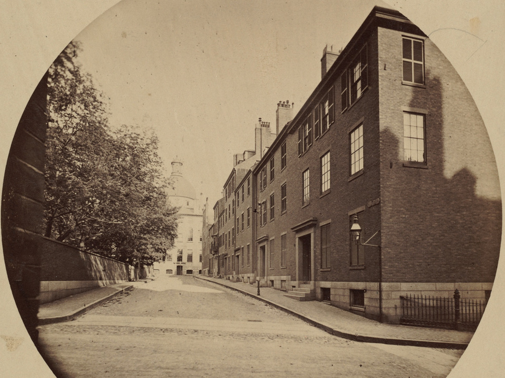
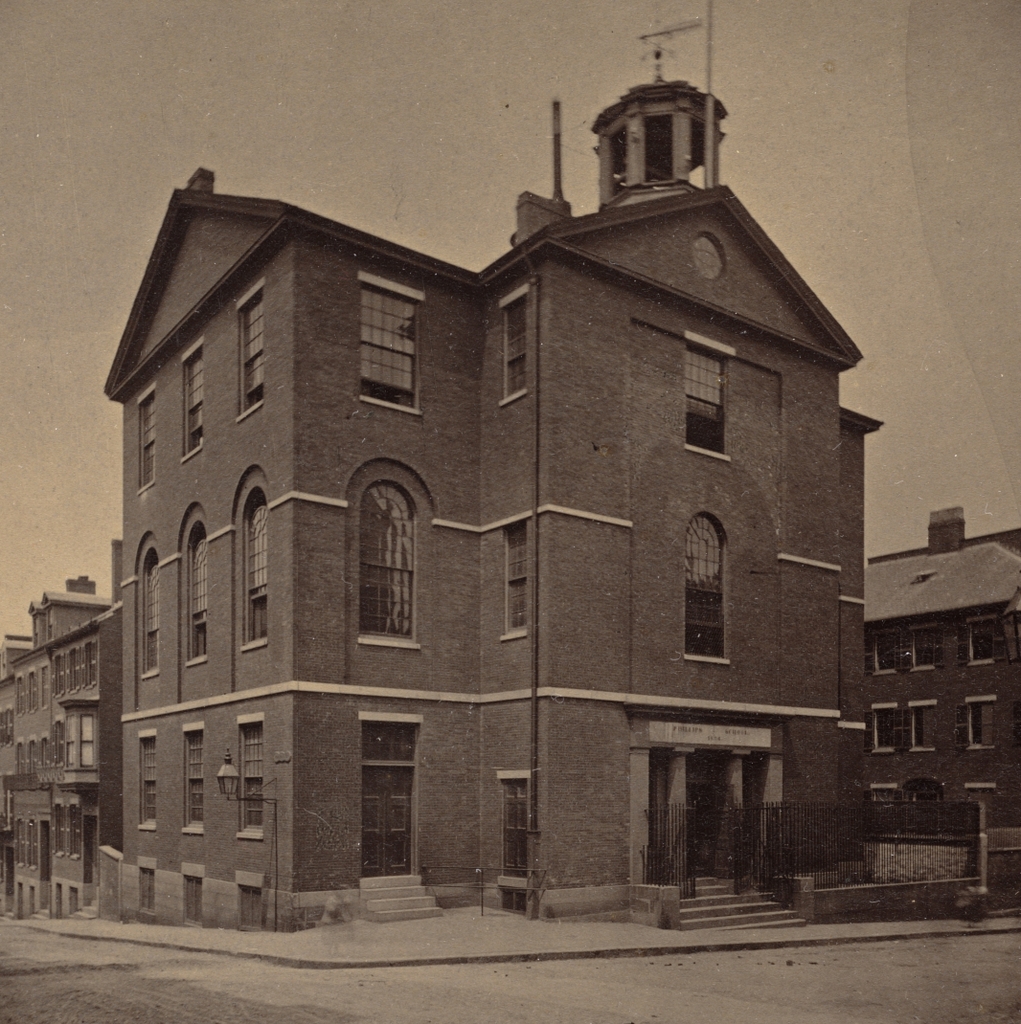
The Phillips School at the corner of Pinckney and Anderson Streets in Boston, in 1860. Photo taken by Josiah Johnson Hawes. Courtesy of the Boston Public Library.

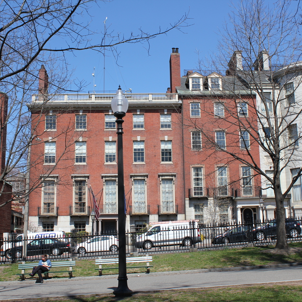
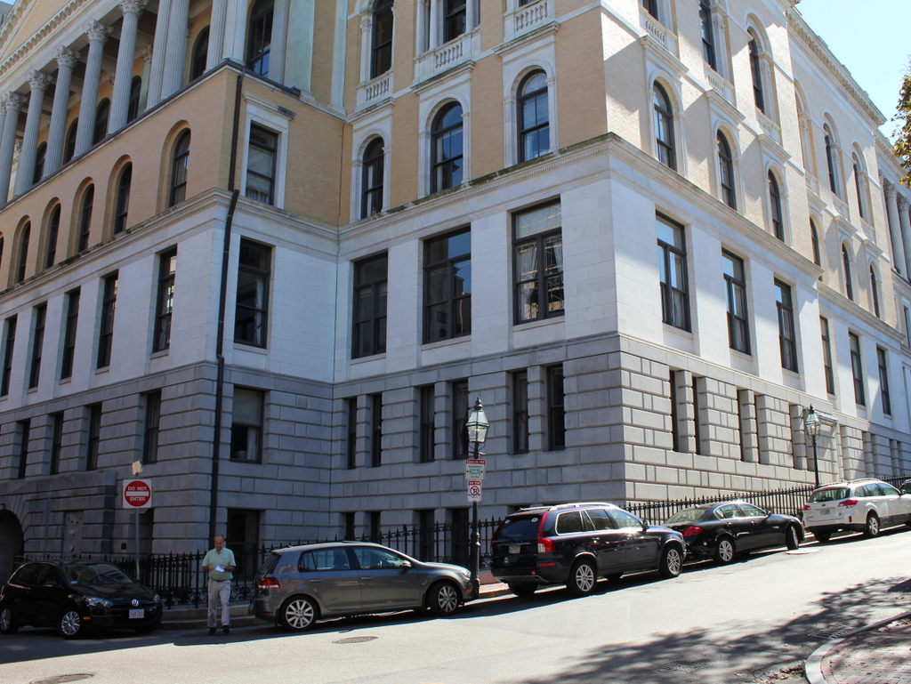
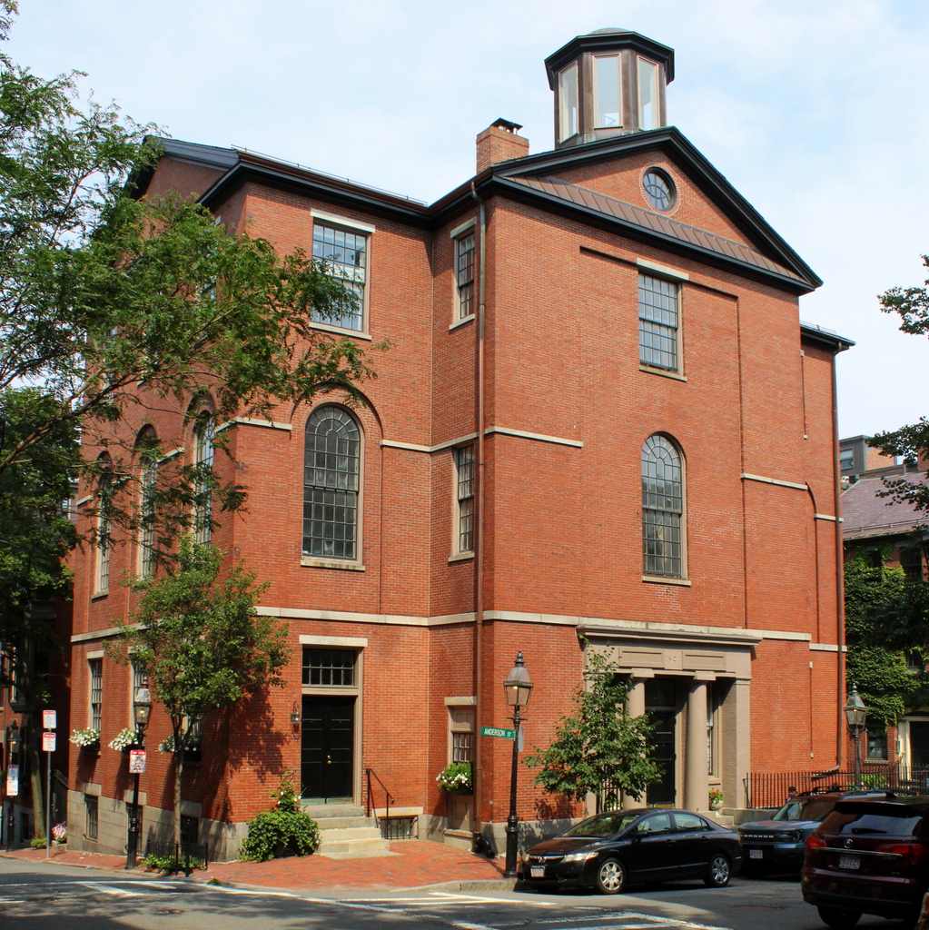
The building in 2021:

A high school education is a near-ubiquitous experience for modern Americans, but this was not always the case. In the early years of the country’s history, secondary education was generally only available to white boys whose families had the inclination and financial ability to send them to a limited number of private academies. However, this concept began to change in the first half of the 19th century, when social reform helped lead to an increased access to education.

One of the first public high schools in the United States was the English High School in Boston, which opened in 1821. Unlike most of the earlier schools, which focused on preparing students for college, this school was intended more for middle class students, particularly those who were looking to become merchants and mechanics. The 1871 book Semi-Centennial History of The English High School provides an overview of the course of study at the school during its early years. In their first year, pupils studied:

Composition; Reading from the most approved authors; Exercises in criticism, comprising critical analyses of the language, grammar, and style of the best English authors, their errors and beauties; Declamation; Geography; Arithmetic continued; Algebra.

In their second year, they studied:

Composition; Reading; Exercises in criticism; Declamation; Algebra; Ancient and modern history and chronology; Logic; geometry; Plane Trigonometry, and its application to mensuration of heights and distances; Navigation; Surveying; Mensuration of superficies and solids; Forensic discussions.

And, in their third year, they studied:

Composition; Exercises in criticism; Declamation; Mathematics; Logic; History, particularly that of the United States; Natural Philosophy including Astronomy; Moral and Political Philosophy.

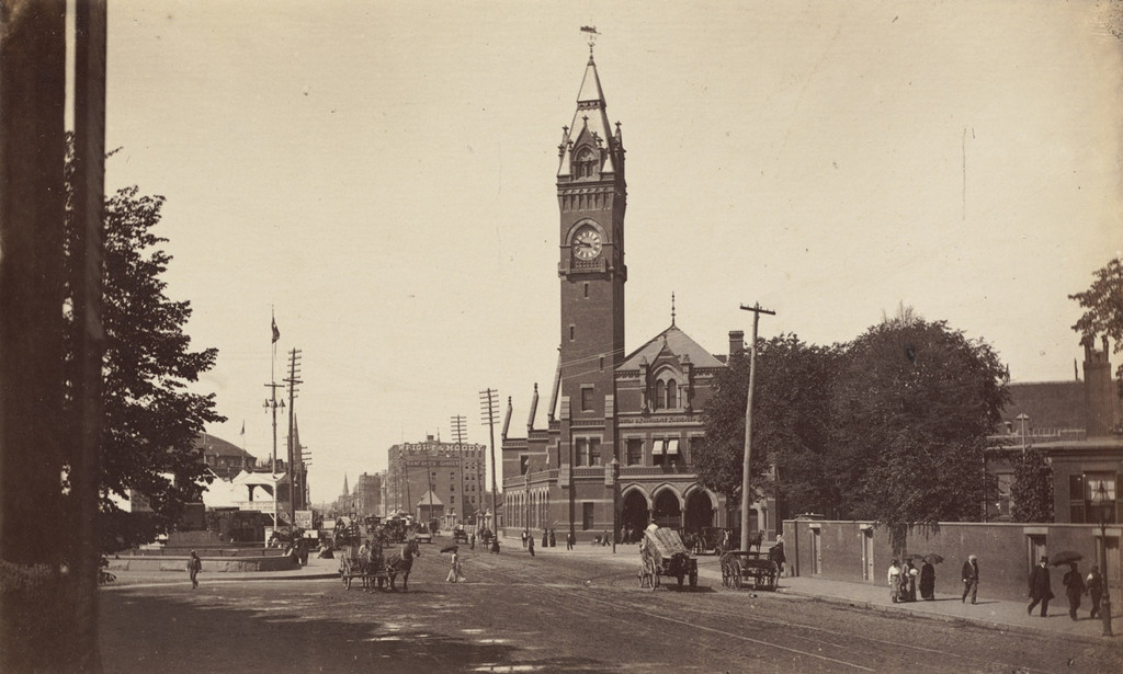
The school was housed at a temporary location for several years, but in 1824 it moved into this newly-constructed building at the corner of Pinckney and Anderson Streets on Beacon Hill. Although this neighborhood is predominantly residential, the school fit in well with its surroundings. Like the nearby rowhouses on Beacon Hill, the school was built of brick, and its design incorporated a blend of older Federal-style architecture with newer Greek Revival-style elements. It was formally dedicated at a ceremony on November 2, 1824, which was attended by a number of city dignitaries, including Mayor Josiah Quincy III and the Reverend John Pierpont, future maternal grandfather of financier J.P. Morgan. An article published in the November 13, 1824 issue of the Boston Recorder describes the event:

This new school house surpasses any other in the city for beauty and accommodations. Besides ample rooms below for ward meetings and other public purposes, the two higher stories contain accommodations for six hundred scholars, and the whole is warmed and ventilated by two furnaces. Its situation, on the most elevated spot in the city, commands a view of the heavens, which most admirably adapts it for astronomical pursuits, which constitute one of the important branches of instruction—and this alone would render it the most eligible location for the seminary. The handsome cupola on the summit is calculated to afford increased facilities for the same pursuit, and together with the commodious apartments below, furnishes, for the first time, sufficient space and accommodations for the preservation & employment of its fine collection of philosophical instruments.

The ceremony of the introduction of the Preceptor and pupils, by the Mayor and Aldermen and School Committee, attended by such parents and other citizens as chose to attend, was a most interesting scene. The Rev. Mr. Pierpont, of the School Committee, commenced by an appropriate and affecting prayer. The address by the Mayor to the pupils, a hundred and forty promising youths, fully explained to them the high privileges and most important advantages they enjoyed for education, the judicious and expensive patronage extended to the Seminary by the public—that in fact nothing was left undone to afford them every facility for their moral and intellectual improvement—and that if these superior advantages were not duly appreciated and improved by them, the fault must be acknowledged entirely their own. He explained to them the obvious and immediate advantages of their several studies for the advancement of their own personal pursuits, and for their improvement and elevation in their political relations as citizens.

The English High School remained at this location for the next 20 years. Enrollment fluctuated during this time, but was generally between 110 and 140 students in any given year. It dropped as low as 104 students in 1839, but by 1843 enrollment had risen to 170, the highest number while the English High School was in this building. However, graduation rates were low throughout this time. Of the 73 students who enrolled here in 1824, for example, only 13 subsequently graduated. Most years saw similar attrition rates, and the largest graduating class during this period was 24, out of 61 students who had entered in 1839.

The English High School relocated to a new building on Bedford Street in 1844, and the old building here on Beacon Hill became a grammar school. It was named the Phillips School, in honor of Boston’s first mayor, John Phillips, and it opened in the fall of 1844. However, just a few months later, on February 1, 1845, it was heavily damaged by a fire that started in a furnace flue in the basement. It was subsequently repaired, and by 1847 the school enrolled 369 boys.

The 1851 book Sketches of Boston, Past and Present includes a description of the school and its students:

The location of the district from which the school is gathered, is one of the most favorable in the city, as its pupils generally come from the first class families. While this fact is beneficial in many respects, it almost necessarily keeps the school “young,” as its pupils are early transferred to higher schools.

What this book’s description of the school did not include was the fact that it was exclusively for white students. At the time, Boston’s public schools were segregated, and black children who lived in the vicinity of Beacon Hill attended the Abiel Smith School, which still stands a few block away on Joy Street. However, change was already underway, beginning in 1848 when a black Boston resident, Benjamin Roberts, sued the city to allow his daughter to attend one of the white schools closer to their house, rather than the Smith School. He lost his lawsuit, and also lost the appeal, when the state’s Supreme Judicial Court upheld Boston’s segregated school system. Undeterred, Roberts then enlisted the help of the abolitionist community, both black and white, and successfully petitioned the state legislature to outlaw school segregation in Massachusetts. This law went into effect in 1855, and Massachusetts became the only state to ban school segregation in the 1800s, nearly a century before the landmark Brown v. Board of Education did the same at the national level.

Here on Beacon Hill, the Phillips School was among the first of Boston’s schools to be integrated, with 15 black students enrolling here for the first day of classes in the fall of 1855. This desegregation in Boston was celebrated by the abolitionist newspaper The Liberator, which declared on September 7, 1855 that:

On Monday last, Boston ceased to be, for the first time in her history, contumaciously unjust and basely proscriptive in regard to equal school rights among her children, irrespective of complexions distinctions.

The newspaper then went on to provide an excerpt from the Evening Telegraph, which described the first day of integration:

The introduction of the colored youth into the schools, we are happy to say, was accomplished with general good feeling on the part of both teachers and white children. At the Phillips School, at the West End, one or two of the white boys were making a little merry sport at the colored pupils as they came up, but the principal, Mr. Hovey, stayed it at once by the quiet remark, ‘Is that your politeness to strangers?’ One enthusiastic white boy ran through Myrtle street, swinging his satchel, and crying out—’Hurrah! we are to have the darkies to-day, and I’m going to have one right side of me!’ . . . The appearance of the colored children in the heretofore by them unfrequented streets leading to the school houses created a ‘sensation’ among the neighbors, who filled the windows, probably in anticipation of trouble. So far as we can hear, there was none, however, in any part of the city.

The first photo was taken only a few years after integration, by prominent photographer Josiah Johnson Hawes. At this point it was still the Phillips School, but within a few years the school would relocate to a new building and would become the Wendell Phillips School, named in honor of the prominent abolitionist and son of the original namesake.

In the meantime, by the late 19th century the old building here in this scene had become a primary school, named the Sharp School. Among the teachers here at the Sharp School was Elizabeth N. Smith, who had been the first black teacher at an integrated school in Boston when she started her career at a different school in 1869. She eventually ended up teaching here at the Sharp School from 1894 until shortly before her death in 1899.

The Sharp School remained here until it closed in 1946, and the building was subsequently sold to the Boston School of Pharmacy. Then, in 1955 the building became the home of the Carnegie Institute, which focused on training medical professionals such as X-ray technicians, lab technicians, medical assistants, and medical secretaries. This school was still around as late as 1980, and was named the Carnegie Division of the Bay State Junior College. However, it appears to have closed soon after, because in 1983 this building was converted into condominiums, after more than 150 years of housing a wide variety of schools.

Today, over 160 years after Josiah Johnson Hawes took the first photo, the exterior of the building has remained well-preserved, despite many changes in use over the years. Its surroundings are also largely unchanged, with most of the early 19th century rowhouses still standing on the narrow streets of Beacon Hill. The old school building is significant not only for its role in the early history of public high school education in America, but also for its pioneering role in school desegregation. It is an important part of the Beacon Hill Historic District, and it is also a stop on the Black Heritage Trail, which highlights the history and landmarks of the free black community that prospered on Beacon Hill during the 19th century.

Third Harrison Gray Otis House, Boston

The Third Harrison Gray Otis House, at 45 Beacon Street in Boston, around 1860. Image courtesy of the Boston Public Library

The house in 2017:


Harrison Gray Otis was a lawyer and politician, and one of the most prominent residents of Boston at the turn of the 19th century. Born in 1765 as a member of the prominent Otis family, he was a young boy when his uncle James became one of the leading anti-British patriots in the years leading up to the American Revolution. After graduating from Harvard in 1783, Harrison subsequently opened his law practice in Boston, and in 1796 he was appointed as the U.S. Attorney for Massachusetts. That same year, he was elected to Congress, and served two terms from 1797 to 1801.

Otis would go on to serve in the state legislature from 1802 to 1817, and was elected to a term in the U.S. Senate from 1817 to 1822. A few years later, he finished his political career by serving as mayor of Boston from 1829 to 1832. However, despite his extensive political career, his greatest legacy in Boston has probably been his three houses on Beacon Hill, all of which are still standing today as some of the finest examples of residential Federal architecture in the country.

All three of his houses were designed by Charles Bulfinch, one of the nation’s most prominent architects of the late 18th and early 19th centuries. The first house, completed in 1796, was built on Cambridge Street, but Otis only lived here for a few years before moving in 1800, to another new house on Mount Vernon Street, near the top of Beacon Hill. He did not live there for very long either, though, because his third house, seen here on Beacon Street, was completed in 1808.

When the house was completed, Beacon Hill was just starting to be developed as an upscale neighborhood for Boston’s elite, and Otis’s house occupied one of the most desirable spots, directly across from Boston Common. Although most of the houses here are townhouses, his was originally built as a freestanding home, with gardens to the right and behind it, and a driveway to the left. The house itself is considered to have been one of Charles Bulfinch’s finest works, and Otis was evidently satisfied with it, because he lived here until his death 40 years later in 1848.

Otis’s political career peaked during the time that he lived here, and this house saw several distinguished guests, including James Monroe, who stayed here during a visit to Boston in 1817, as well as Senator Henry Clay. With Beacon Hill becoming the city’s most desirable and exclusive neighborhood, though, property values rose to the point where Otis could no longer justifying having large gardens around his house. So, in 1831 he sold a 25-foot wide section of his garden to his neighbor, David Sears, who built an addition to his own house. This granite townhouse, which can be partially seen on the far right, was built for his daughter Anna and her husband William Amory, who was a prominent textile manufacturer. Two years later, Otis filled in the gap between the two houses by building 44 Beacon Street, directly adjacent to his own house, for his daughter Sophia and her husband, Andrew Ritchie.

By the time Harrison Gray Otis died in 1848, his formerly freestanding home had been mostly incorporated into the streetscape of Beacon Street. The only remnant of the gardens that once surrounded his home is the driveway on the left, which leads to a carriage house in the backyard. A rarity in Beacon Hill, this driveway is the only break in an otherwise continuous row of houses on Beacon Street between Walnut and Spruce Streets. When the first photo was taken about 12 years after his death, the house and its surroundings had already assumed its present-day appearance, and there is hardly any difference despite being taken over 150 years apart.

When the first photo was taken, the house was owned by brothers Samuel and Edward Austin, both of whom were merchants. Neither brother ever married, and after Samuel’s death, Edward continued to live here for many years, until his own death in 1898 at the age of 95. The property changed hands several more times in the first half of the 20th century, and by 1940 it was owned by the Boy Scouts, who used it as offices until 1954. Since 1958, it has been owned by the American Meteorological Society, and it is used as the organization’s headquarters. During this time, the interior was significantly renovated, but the exterior of the house has remained well-preserved, and it still stands as one of the finest homes in the Beacon Hill neighborhood.

Mount Vernon Place, Boston

Mount Vernon Place, seen from Joy Street in Boston around 1860. Image taken by Josiah Johnson Hawes, courtesy of the Boston Public Library.

829_1860 bpl

Mount Vernon Place in 2105:

829_2015
Mount Vernon Place is a short street in Boston’s Beacon Hill neighborhood, located just west of the Massachusetts State House. It was once a full block long, and was developed in the 1830s on land that had once been owned by John Hancock and his family. As the 1860 photo shows, the street had a small park on the left side and eight townhouses on the right, and at the end of the street was the State House. The five houses closest to the State House were demolished in the 1910s when the building was expanded, and today only the three in the foreground survive. These three were built around 1833-1834, and have been largely unaltered on the exterior since then. They are among the many historic early 19th century townhouses that have become a defining feature of Beacon Hill, and they form a part of the Beacon Hill Historic District on the National Register of Historic Places.

Beacon Hill Reservoir, Boston

The reservoir atop Beacon Hill in Boston, around 1860. Image taken by Josiah Johnson Hawes, courtesy of the Boston Public Library.

828_1860 bpl

The scene in 2015:

828_2015
Long before the Wachusett and Quabbin Reservoirs, Boston’s municipal water supply was Lake Cochituate, a reservoir in Natick, Framingham, and Wayland. The project began in 1845, and it included not only creating the artificial lake, but also building a 14-mile long aqueduct that fed this stone reservoir atop Beacon Hill, just behind the Massachusetts State House. From here, the water was distributed throughout the city, using the hill’s elevation to carry the water downhill through the pipes. It occupied the majority of the block between Hancock, Derne, Temple, and Mt. Vernon Streets, and it had a capacity of over 2.6 million gallons.

The structure’s cornerstone laying ceremony in 1847 included a time capsule, which contained several publications and two silver plates, perhaps in the hope that, like the great Roman aqueducts in Europe, this public water supply structure would last for thousands of years. However, as it turned out, it lasted for less than 40. It closed by about 1880, and around three years later it was demolished to build a large expansion of the Massachusetts State House, which now occupies the site where this reservoir once stood.

Bowdoin Square Baptist Church, Boston

The Bowdoin Square Baptist Church in Boston, around 1860. Image taken by Josiah Johnson Hawes, courtesy of the Boston Public Library.

825_1860c bpl

Bowdoin Square in 2015:

825_2015
This scene shows Bowdoin Square facing the opposite direction from the one in the previous post, facing east on Cambridge Street toward Government Center. The most prominent building in the first photo is the Bowdoin Square Baptist Church, a Gothic Revival style church that was built in 1840. Its design is very similar to several other churches that were built in Boston around the same time, including the old Trinity Church on Summer Street and the nearby Bowdoin Street Congregational Church, which is still standing today as the Saint John the Evangelist Mission Church.

The church here at Bowdoin Square gained some notoriety in 1885, when the congregation split after the pastor, William W. Downs, was found in what was alleged to be a “compromising position” with a woman from his church. The scandal was well-publicized in newspapers across the country, and the church split into two factions, with one supporting his removal and the other believing his claims that he was the victim of a conspiracy. He was eventually dismissed from his position, and the church closed, but he maintained his innocence and several years later won a lawsuit against his accusers, with the jury awarding him $10,000 in damages.

Following the Downs scandal, the church became the Bowdoin Square Baptist Tabernacle, and it was extensively remodeled on the exterior and interior in 1898. However, the church sold the building in 1916 to the New England Telephone and Telegraph Company. Around 1930, they demolished the church and the neighboring Coolidge Building to the right, in order to build their new Boston headquarters, which is still standing in the 2015 photo. None of the other buildings remain from the 1860 photo, either; most of this section of Boston was demolished in the 1950s and 1960s as part of the West End and Government Center urban renewal projects.

Boston and Providence Depot, Boston

The Boston and Providence Depot at Park Square in Boston, around 1860. Image courtesy of the Boston Public Library.

815_1860c bpl

The station around 1885. Image courtesy of the Boston Public Library.

815_1885c bpl

The scene in 2015:

815_2015

The Boston and Providence Railroad opened in 1835, at a time when Boston was still a peninsula connected to the mainland by a narrow isthmus. To avoid taking up scarce land, the railroad built a long trestle across the Back Bay, which at the time was a tidal marsh between Boston and Roxbury. The railroad terminal was built here at the edge of the water, at what eventually became Park Square.

The original station from the first photograph was demolished in the early 1870s so that the city could build Columbus Avenue, and it was replaced with the much larger station in the second photograph. In advertisements, it was hailed as “The Palace Depot of the World,” and from here passengers could board a train for Providence, New York, and other points south. However, by the late 19th century there were eight different railroads serving Boston, each of which operated its own separate station. The four railroads on the north side all had terminals near where North Station would be be built in 1893, and three of the south side terminals were located in the immediate vicinity of today’s South Station. The Providence and Worcester depot was the one outlier; it was on the south side, but it was a half mile away from the next closest station.

Because the multiple stations were both inconvenient for passengers and a waste of valuable property, the four south side railroads finally consolidated into South Station in 1899. This station and the tracks leading to it were closed, and the railroad, which by then had been leased to the New York, New Haven and Hartford, was rerouted onto new tracks, parallel to the Boston & Albany Railroad.

Today, none of the buildings from the first two photos are still standing. The site of the station is now the Boston Park Plaza Hotel, which was built in 1927 as the Hotel Statler Boston in the triangular block between Columbus Avenue, Park Plaza, and Arlington Street. The only visible remnant from the first photo is the Emancipation Memorial statue, which was added to Park Square in 1879 and can be seen on the far left of both photos.