John Hancock House, Boston

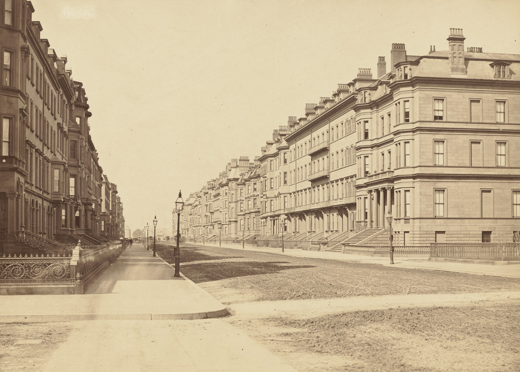
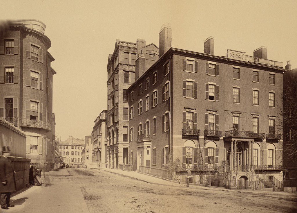
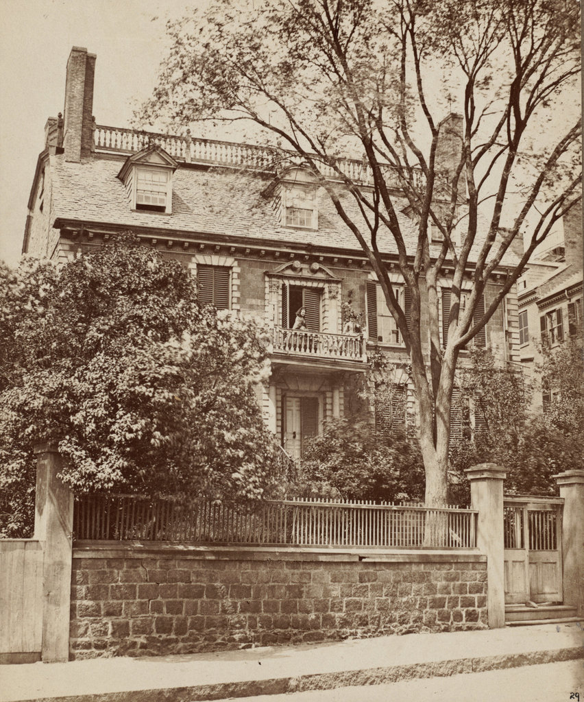
The John Hancock House on Beacon Street in Boston, around 1860. Image courtesy of the Boston Public Library.
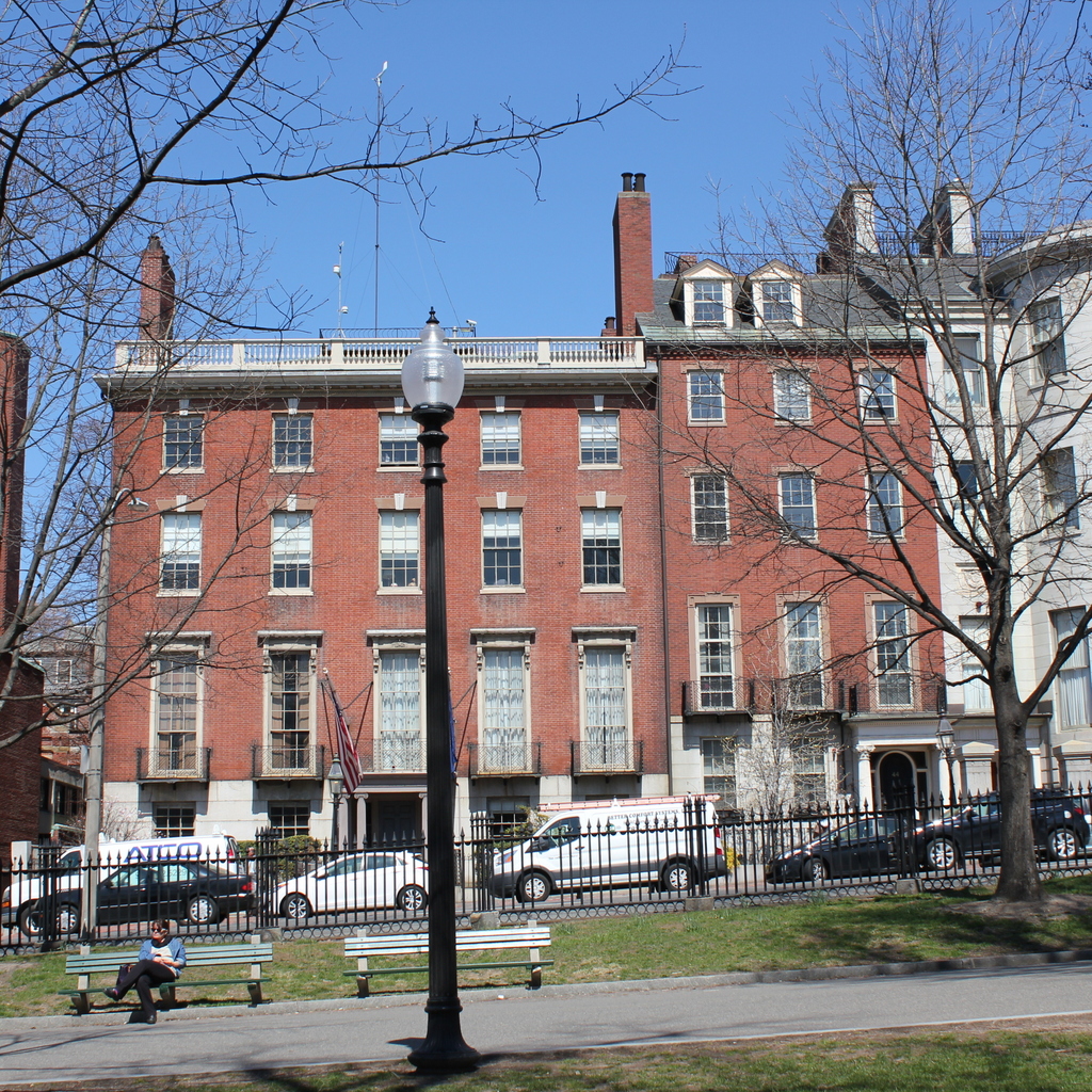
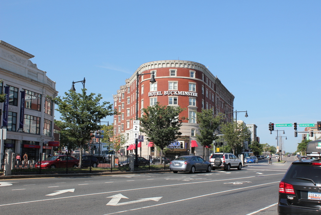
The scene in 2017:


This grand mansion was built in the mid-1730s for Thomas Hancock, a wealthy Boston merchant. At the time, Beacon Hill was on the outskirts of Boston, and this house was the westernmost one on Beacon Street. Here, Thomas and his wife Lydia created what amounted to a country estate, with gardens, orchards, and pastureland that extended up the southern slope of hill, and was directly across the street from Boston Common. Despite the pastoral setting, though, the was within easy walking distance of Boston’s wharves, where Hancock conducted his business. The house itself was built of granite, and was an outstanding example of Georgian architecture, complete with a balcony that offered sweeping views of Boston and the the surrounding harbor.

Thomas and Lydia had no children of their own, but in 1744 Thomas’s brother John died, and his seven-year-old son, also named John, moved to Boston and lived here in this house. After graduating from Boston Latin School in 1750 and Harvard College in 1754, John Hancock joined his uncle’s firm, eventually taking over the business after Thomas’s death in 1764. Along with the business, he also inherited his uncle’s estate here on Beacon Hill, and he went on to live here for the rest of his life.

John Hancock went on to become one of the most prominent Patriots in the years leading up to the American Revolution, and in 1774 he was elected as a Massachusetts delegate to the Second Continental Congress. From 1775 to 1777, he served as the President of the Continental Congress, and it was in this capacity in 1776 that he famously signed the Declaration of Independence. Following his time in Congress, he briefly served in the war as a major general in the Massachusetts militia, and in 1780 he was elected as the first governor of Massachusetts. Widely popular, he easily won re-election every year until 1785, when he resigned due to ill health.

Later in 1785, James Bowdoin was elected as his successor, but his two years as governor were marked by a failing economy and a poor response to Shays’ Rebellion in 1786-1787. As a result, Hancock ran against him in the 1787 election and won easily, and he went on to win re-election every year until his death in 1793. During this time, he pardoned those involved in Shays’ Rebellion, and he was also an influential proponent of the U.S. Constitution, which was narrowly ratified by the state in 1788, probably thanks to his support. In the absence of an official governor’s mansion, Hancock’s house served that purpose well, and he received a number of distinguished visitors here, including the Marquis de Lafayette in 1781 and George Washington in 1789.

By the time John Hancock died in 1793, this house was no longer at the outskirts of Boston, and Beacon Hill was in the process of being transformed into an exclusive neighborhood of elegant townhouses. Portions of the estate were steadily sold, including land to the east of the house, which became the site of the Massachusetts State House. Other parcels were sold for new homes, and by the early 19th century the house was surrounded by more modern homes. Hancock’s widow, Dorothy, had remarried in 1796, and she lived here in this house until 1816. The house remained in the family, though, with John Hancock’s nephew, also named John, owning the house until his death in 1859.

The first photo was taken sometime around the time when the younger John Hancock died, and it shows his granddaughter, Elizabeth Lowell Hancock Moriarty, standing on the second floor balcony. Despite being over a century old, the house still retained its stately elegance, and was recognized as an important landmark. There had been several different proposals for using the house, including the possibility of purchasing it as an official governor’s mansion. The family even offered the property to the state for the low price of $100,000, but many balked at the idea of such an expense, and the idea was dropped.

The property was finally sold in 1863, with the intention of redeveloping it with modern townhouses. The state was offered one last chance to move the house to a new location, but again there was significantly opposition to the $12,000 expense, and the historic house was ultimately demolished in the summer of 1863. Had it survived, the house would have become one of the city’s iconic Revolutionary War landmarks, on par with such places as the Old State House, the Paul Revere House, and Old North Church. Instead, though, its demolition did help to spur preservation movements for some of these other landmarks, including the Old South Meeting House, which survived similar redevelopment threats a decade later.

In 1865, two townhouses were built on the site of Hancock’s house. However, these houses did not last nearly as long as their predecessor, because in 1917 they were demolished to build a new wing of the Massachusetts State House. Since then, not much has changed. The 1798 state house, with its various additions over the years, remains in use as the state capitol building, and the surrounding Beacon Hill neighborhood is still home to many of Boston’s wealthy residents, nearly 300 years after Thomas Hancock first made his home here.

Third Harrison Gray Otis House, Boston

The Third Harrison Gray Otis House, at 45 Beacon Street in Boston, around 1860. Image courtesy of the Boston Public Library

The house in 2017:


Harrison Gray Otis was a lawyer and politician, and one of the most prominent residents of Boston at the turn of the 19th century. Born in 1765 as a member of the prominent Otis family, he was a young boy when his uncle James became one of the leading anti-British patriots in the years leading up to the American Revolution. After graduating from Harvard in 1783, Harrison subsequently opened his law practice in Boston, and in 1796 he was appointed as the U.S. Attorney for Massachusetts. That same year, he was elected to Congress, and served two terms from 1797 to 1801.

Otis would go on to serve in the state legislature from 1802 to 1817, and was elected to a term in the U.S. Senate from 1817 to 1822. A few years later, he finished his political career by serving as mayor of Boston from 1829 to 1832. However, despite his extensive political career, his greatest legacy in Boston has probably been his three houses on Beacon Hill, all of which are still standing today as some of the finest examples of residential Federal architecture in the country.

All three of his houses were designed by Charles Bulfinch, one of the nation’s most prominent architects of the late 18th and early 19th centuries. The first house, completed in 1796, was built on Cambridge Street, but Otis only lived here for a few years before moving in 1800, to another new house on Mount Vernon Street, near the top of Beacon Hill. He did not live there for very long either, though, because his third house, seen here on Beacon Street, was completed in 1808.

When the house was completed, Beacon Hill was just starting to be developed as an upscale neighborhood for Boston’s elite, and Otis’s house occupied one of the most desirable spots, directly across from Boston Common. Although most of the houses here are townhouses, his was originally built as a freestanding home, with gardens to the right and behind it, and a driveway to the left. The house itself is considered to have been one of Charles Bulfinch’s finest works, and Otis was evidently satisfied with it, because he lived here until his death 40 years later in 1848.

Otis’s political career peaked during the time that he lived here, and this house saw several distinguished guests, including James Monroe, who stayed here during a visit to Boston in 1817, as well as Senator Henry Clay. With Beacon Hill becoming the city’s most desirable and exclusive neighborhood, though, property values rose to the point where Otis could no longer justifying having large gardens around his house. So, in 1831 he sold a 25-foot wide section of his garden to his neighbor, David Sears, who built an addition to his own house. This granite townhouse, which can be partially seen on the far right, was built for his daughter Anna and her husband William Amory, who was a prominent textile manufacturer. Two years later, Otis filled in the gap between the two houses by building 44 Beacon Street, directly adjacent to his own house, for his daughter Sophia and her husband, Andrew Ritchie.

By the time Harrison Gray Otis died in 1848, his formerly freestanding home had been mostly incorporated into the streetscape of Beacon Street. The only remnant of the gardens that once surrounded his home is the driveway on the left, which leads to a carriage house in the backyard. A rarity in Beacon Hill, this driveway is the only break in an otherwise continuous row of houses on Beacon Street between Walnut and Spruce Streets. When the first photo was taken about 12 years after his death, the house and its surroundings had already assumed its present-day appearance, and there is hardly any difference despite being taken over 150 years apart.

When the first photo was taken, the house was owned by brothers Samuel and Edward Austin, both of whom were merchants. Neither brother ever married, and after Samuel’s death, Edward continued to live here for many years, until his own death in 1898 at the age of 95. The property changed hands several more times in the first half of the 20th century, and by 1940 it was owned by the Boy Scouts, who used it as offices until 1954. Since 1958, it has been owned by the American Meteorological Society, and it is used as the organization’s headquarters. During this time, the interior was significantly renovated, but the exterior of the house has remained well-preserved, and it still stands as one of the finest homes in the Beacon Hill neighborhood.

Beacon Street from Arlington Street, Boston

Looking west on Beacon Street from the corner of Arlington Street, in 1870. Image courtesy of the Boston Public Library.

812_1870 bpl

Beacon Street in 2015:

812_2015

The houses on the right side of this scene are the oldest buildings in the Back Bay, dating back even before the large-scale landfill project had begun. The origins of Beacon Street date back to 1818, when construction began on a dam across the Back Bay, which at the time was a tidal marsh connected to the Charles River. The dam used the power of the tides to operate factories nearby, but it also had an added benefit of serving as a second route in and out of Boston, by extending Beacon Street across it.

The dam, which was completed in 1821, turned out to be a failure, and by the 1850s there were plans in the works to fill the Back Bay and expand Boston’s land area. The houses here on the right side of the street were built around 1856 on land that had already been filled; they can be seen in the distance in the first photo in this post, which was taken from the top of the State House in 1857. By the time the 1870 photo above was taken just 13 years later, the landfill project was well underway, and both sides of Beacon Street had been developed as far as Dartmouth Street, three blocks in the distance.

Nearly 150 years after the first photo was taken, many of the buildings from the first photo are still standing, including most of the 1850s houses to the right. The only major change in the foreground is the pair of houses on the far right, numbered 100-102 Beacon Street. Half of the building was demolished in 1924 to build the apartment building that stands there today. The other half at 102 Beacon is still standing, although it was altered beyond recognition in 1938, when it was converted into an 18-unit apartment building with a new facade. However, the next seven houses in a row, numbered 104-116 Beacon Street, also date back to around 1856. They are all virtually identical, and 160 years later all seven are still standing, essentially unchanged on the exterior. The use of the buildings has changed, though; today, all seven, along with the neighboring properties at 102 and 118 Beacon Street, are owned by Fisher College and are used for classrooms and dormitories.

For more information on the history of these houses, see the Back Bay Houses website.

Kenmore Square, Boston

Facing east in Kenmore Square, with Beacon Street to the left and Commonwealth Avenue to the right, on November 14, 1911.  Image courtesy of the City of Boston Archives.

709_1911-11-14 coba

Kenmore Square in 2015:

709_2015
The area that makes up Kenmore Square today was originally Sewall’s Point, on the edge of a large tidal marsh along the Charles River.  These photos were taken right about where the shoreline once was when European settlers first arrived in 1630, and there was no dry land from here until Boston Common, around a mile and a half away. This “back bay” of Boston remained relatively unchanged for nearly 200 years, and the site of Kenmore Square, which technically wasn’t even part of Boston at the time, remained undeveloped.

Things started to change in 1821, when the Mill Dam was built across the Back Bay from here to Boston Common.  The idea was to use the tide to power factories in the area, and although that aspect of it was a failure, the dam was also used as a toll road.  Later in the 19th century, when the Back Bay was filled in, the road on the old dam became Beacon Street.  The original dam was never actually dismantled, so the wooden structure is still buried under the road today.

Once the landfill projects were completed around 1900, this area became the intersection of three major roads: Beacon Street, Commonwealth Avenue, and Brookline Avenue.  The houses along Commonwealth Avenue were primarily built in the 1890s, and within the next few decades larger commercial buildings opened here. The first was the 1897 Hotel Buckminster, which is located just behind where these photos were taken.

In the past century, Kenmore Square has not undergone drastic changes.  Many of the houses along Commonwealth Avenue are still standing, as are some of the commercial buildings to the left. Today, the square is probably best known for its association with the Boston Red Sox.  Fenway Park, which was under construction when the first photo was taken, is less than 300 yards to the right along Brookline Avenue, and the large Citgo sign that is prominently visible from the park is just out of view to the left, on top of Barnes & Noble building on the far left.

Beacon and Park Streets, Boston

Looking east on Beacon Street from in front of the State House, sometime around 1885. Image courtesy of the Boston Public Library.

692_1800sc bpl

The scene in 2022:


Despite all of the changes in downtown Boston during the past 130 years, there are several buildings from the first photo that survive today.  The building at the corner doesn’t bear much resemblance to its former self, but it is the same one that is seen in the first photo.  It was built in 1804 for merchant Thomas Amory Jr., and was one of several houses on Park Street that were designed by Charles Bulfinch.  The home occupies a prominent position next to the Boston Common and across the street from the Massachusetts State House, but the cost for the massive house ruined Amory’s finances, and he had to sell it in 1807.

After Amory sold it, the house was divided into four different units, which were rented to some of Boston’s most prominent citizens.  Senator and Cabinet member Samuel Dexter lived here, and Christopher Gore took advantage of the house’s proximity to the State House and lived here while serving as governor in 1809 and 1810.  In 1824, the Marquis de Lafayette stayed here during his tour of the United States, and Boston Public Library founder George Ticknor lived on the Park Street side of the house from 1830 until his death in 1871.  Around 1885, the house was extensively renovated on the exterior, with iron storefronts replacing the original first floor windows, oriel windows on the third and fourth floors, and three dormers on the right-hand side of the roof.  Today, several different businesses occupy the first floor storefronts, including Fox 25 News in the corner storefront.

The other historic building that has survived from the first photo is the Claflin Building, located just beyond the Amory-Ticknor House on Beacon Street.  It was completed in 1884, and is one of architect William Gibbons Preston’s several surviving buildings in Boston, along with the Armory of the First Corps of Cadets and the Museum of Natural History building.  The Claflin Building was built for the newly-founded Boston University, who used the upper floors for school offices and rented the first floor storefronts.  The school owned the building until the 1940s, when it moved to its present campus on Commonwealth Avenue, and today it has been renovated into condominiums.

Hotel Buckminster, Boston

The Hotel Buckminster at Kenmore Square in Boston, around 1911. Image courtesy of the City of Boston Archives.

662_1911c coba

The hotel in 2015:

662_2015
The present-day Kenmore Square area was once just swampy land along the edge of the Charles River, separated from Boston the tidal flats of the Back Bay.  Boston began to fill in this land starting in the late 1850s at Arlington Street and steadily moving west.  The landfill project in the Fenway area was completed by the 1890s, and in 1897 the Hotel Buckminster opened as the first hotel at Kenmore Square, in between Brookline Avenue to the left and Beacon Street to the right.  Even by 1911, as seen in the first photo, the neighborhood was still sparsely developed.  Just a year after the photo was taken, the Red Sox would open Fenway Park on a vacant lot just two blocks south of here along Brookline Avenue.

Because of its proximity to Fenway Park, visiting teams would often stay at the hotel while they were in town.  Babe Ruth had a favorite room on the top floor along the Brookline Avenue side that overlooked Fenway Park, and it was also here that Boston bookmaker Joseph “Sport” Sullivan met with Chicago White Sox first baseman Chick Gandil and conspired to fix the 1919 World Series.  Later on, the radio station WNAC had its studio in the hotel, and in 1929 the world’s first network radio broadcast was sent from here.  From 191 to 1953, the Storyville nightclub was located in the building, and featured a number of notable jazz musicians, including Louis Armstrong, Billie Holiday, and Charlie Parker.

Over a century after the first photo was taken, the Hotel Buckminster is still around, although the neighborhood around it has grown significantly.  Although visiting teams probably don’t stay at this hotel anymore, the Kenmore Square is the primary subway station for fans going to and leaving Fenway Park, and there are a number of restaurants and other businesses that benefit from the sizable gameday crowds.  It is also a major intersection, with Beacon Street, Commonwealth Avenue, and Brookline Avenue all converging here above ground, and the “B”, “C”, and “D” branches of the Green Line meeting underground.  State Route 2 passes through here as well, and US Route 20, the longest road in the country, ends at Beacon Street, right in front of the hotel.