Park Street Subway Station, Boston (4)

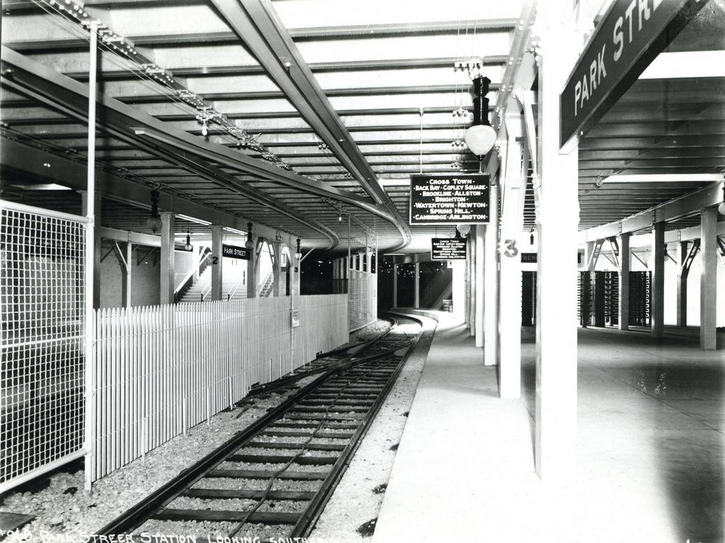
Another view of the Park Street station on the Tremont Street Subway, taken on July 31, 1897. Image courtesy of the City of Boston Archives.

694_1897-07-31 coba

The station in 2015:

694_2015
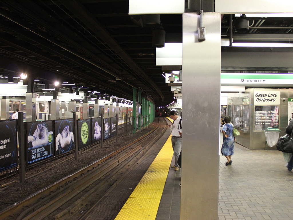
The first photo shows the interior of Park Street station as it appeared about a month before it opened as one of the first two subway stations in the United States.  It was taken from around the same location as the one in the previous post, just facing the opposite direction.  These two photos, taken nearly 120 years apart, show some of the changes that have taken place over the years inside this historic station.  The original 1897 trolley platforms soon became inadequate for the number of passengers that used the station, so from 1914 to 1915 they were extended to the south, which is why the station appears much larger in the 2015 photo.  Other changes have included removing the two stairwells that can be seen at the southern end of the platforms in the first photo; today, the station can only be accessed through the entrances closest to Park Street.

Not everything has changed, though.  One of the defining features of the Green Line is that it still runs trolleys rather than conventional rapid transit subway cars like those on the other three subway lines.  As a result, the station platforms are level with the tracks, and there is no third rail, with power instead being supplied by overhead wires.  Many of the destinations haven’t changed either.  Although Boston’s trolley network is significantly smaller than it was in 1897, many of the places on the sign in the first photo can still be accessed from here, including the Back Bay, Copley Square, Brookline, Allston, Brighton, and Newton.

Boston and Maine Station, Boston

The Boston and Maine Railroad station at Haymarket Square in Boston, around 1894. Image courtesy of the City of Boston Archives.

689_1894c coba

The Boston City Hospital Relief Station, on the site of the former railroad station in 1905. Image courtesy of the City of Boston Archives.

689_1905-11-05

The location in 2015:

689_2015
Of the eight major railroads that served Boston in the late 1800s, the Boston and Maine came the closest to the downtown area, with its depot at Haymarket Square. It was opened in 1845, and over the years Boston and Maine became the dominant railroad in northern New England, with many of its lines converging here.  However, because there were four different railroads that had their own stations within a few blocks of here, the companies built North Station in 1893, about 300 yards up Canal Street from here.

The old station had been built in the early years of railroad travel, and it stood until 1897, when it was demolished to make way for a new type of rail travel.  Boston’s Tremont Street Subway was the first subway tunnel in the country, and the northern entrance of the tunnel was built on the site of the station.  From here, the tracks ran along the surface between Canal and Haverhill Streets, where the station platforms used to be.  The only new building on the site was the Boston City Hospital Relief Station, as seen in the 1905 photo.  It was built in 1902 as a branch of the Boston City Hospital, in order to provide emergency services in the downtown area, and it stood until the early 1960s.

Today, there isn’t much left from either of the first two photos.  A few of the buildings on Canal Street are still standing, such as the one on the far left in both the 1891 and 1905 photos.  It is barely visible on the left of the 2015 photo, above the bus in the foreground.  Haymarket Square itself is completely changed, though, through a series of urban renewal projects in the 20th century.  To the left is a parking garage, with the Haymarket Square subway station underneath it.  On the right-hand side of the photo, the elevated Central Artery once passed through here.  Built in the 1950s, it cut a swath through downtown Boston until 2003, when the highway was rerouted through the Tip O’Neill Tunnel as part of the Big Dig.  The building under construction in the background is being built on land that the Central Artery once passed through.

North Station, Boston

The original North Station on Causeway Street in Boston, around 1893-1899. Image courtesy of the Library of Congress, Detroit Publishing Company Collection.

688_1890-1899c loc

The scene in 2015:

688_2015
Oliver Wendell Holmes once wrote about Boston as being “The Hub of the Solar System,” and although he was using the phrase sarcastically, the city would soon become the transportation hub of New England.  By the late 1800s, there were at least eight railroads that radiated outward from Boston, with each one having its own separate terminal.  However, these eight different stations were both inconvenient for passengers and also a poor use of valuable land.

Here in the northern part of the city, four different railroads each had their own stations within a several block radius: the Boston and Maine, Boston and Lowell, Eastern Railroad, and the Fitchburg Railroad.  All but the Boston and Maine had their passenger terminals in a row here along Causeway Street, so in 1893 the North Union Station opened here, consolidating all four railroads into one building.  It was designed by Shepley, Rutan and Coolidge, a prominent Boston architectural firm that would design South Station six years later, when the four south side terminals were likewise consolidated.

The original North Station was demolished in 1927 to build the Boston Garden, which also included a reconstructed station.  Boston Garden was home to the Boston Bruins from 1928 to 1995, and the Boston Celtics from 1946 to 1995, and the it was demolished in 1998, three years after the completion of the present-day TD Garden.  Today’s North Station is located directly underneath the TD Garden, although today none of the four railroads that opened the first station even exist anymore.  Amtrak has only one passenger route, the Downeaster, that stops here, although it is the terminal for four of the MBTA Commuter Rail lines.  Above the station, the Bruins and Celtics still play here, just behind the spot where the Boston Garden once stood.

Boylston Station, Boston

The Boylston subway station, at the corner of Tremont and Boylston Streets in Boston, on August 12, 1897. Image courtesy of the City of Boston Archives.

687_1897-08-12 coba

The station in 2015:

687_2015
The first photo captures the ending of one era and the beginning of another.  Just a few weeks after the photo was taken, the trolleys that are seen here on congested Tremont Street would be moved underground, giving Boston the distinction of having the country’s first subway tunnel.  The first two stations were Park Street, just over a quarter mile to the north, and this one here at Boylston Street, in the southeast corner of Boston Common.  The project was a major civil engineering milestone, but it didn’t come without tragedy.  At this location earlier in the year, a leaking gas line in the work area under the intersection caused an explosion that killed six people.  The explosion is explained further in this post, which features photos that were taken diagonally across the street from here.

Today, the view really hasn’t changed too much.  The trolleys on the Green Line are still running under this intersection, the distinctive station entrances are still here, as is Boston Common in the background.  Even in the 19th century, this intersection of Boylston and Tremont streets was busy, necessitating the police officer in the left center of the 1897 photo.  The slow shutter speed of the camera has blurred most of the traffic around him, but he is standing perfectly still, posing for the photographer as trolleys, carriages, and pedestrians pass by.  It is still a major intersection today, albeit without the nostalgia of a 19th century officer directing traffic on a cobblestone street.

Boston Public Library, Boston

The Boston Public Library’s McKim Building at Copley Square in 1899. Image courtesy of the Library of Congress, Detroit Publishing Company Collection.

674_1899c loc

The building in 2015:

674_2015
This style of Renaissance Revival architecture was common for public libraries in the United States in the early 20th century, but Charles Follen McKim’s design for the Boston Public Library was the first.  It was constructed between 1888 and 1895, and is one of the most architecturally significant library buildings in the country.  It set the stage for similar grand libraries in American cities, including the main branch of the New York Public Library, which opened just over a decade later. Like many of Boston’s other cultural institutions, the library was strategically located in the Back Bay neighborhood, which had gone from polluted tidal marsh to affluent residential neighborhood in less than 50 years. However, one of the challenges in constructing large buildings here was the high water table and the tendency of the filled-in ground to subside.  As a result, the 19th century Back Bay buildings are supported by wooden piles; the library alone has about 4,000  piles that were driven 25 to 31 feet into the ground in the 1880s.

Today, the McKim Building is well-preserved on both the exterior and interior.  The interior includes a grand staircase and the massive Bates Hall reading room, along with a central courtyard, all of which was, as the inscription reads, “dedicated to the advancement of learning.” The main branch of the Boston Public Library has since outgrown the original building, so in 1972 an addition was put on the back, expanding the building to include the entire city block between Dartmouth and Exeter Streets.  Named after its architect, Philip Johnson, this building houses the library’s circulating collections, leaving the original building for the library’s extensive research collections.  Many of these collections are also available online, including a large number of historic photographs on Digital Commonwealth, which has been a great resource for this blog.

The greatest change in this scene, however, is the city around the library.  The section of the Back Bay to the north of Boylston Street has been largely preserved in its original Victorian appearance.  However, to the south of Boylston Street, as seen here, the area has become home to some of the city’s tallest buildings, including the Prudential Tower to the right, the second-tallest in New England after the nearby John Hancock Tower.  Probably the oldest building in the 2015 photo other than the library is the Lenox Hotel, barely visible on the far right beyond the library.  It was built in 1900, so it may have even been under construction when the first photo was taken.

Main Street, Southington, Connecticut (2)

The view looking north on Main Street in Southington, from just south of Columbus Avenue, around 1885-1891. Image courtesy of the New York Public Library.

658_1885-1891 nypl

Main Street in 2015:

658_2015
This view is very similar to the photos in this post, which were taken just a little further up the street beyond the intersection.  Unlike the other Southington photos that I have featured here, this one was not taken by the Office of War Information during World War II; instead, this image was from a 19th century stereocard.  In this scene, the Soldiers’ Monument on the green had just recently been dedicated, and most of the town’s Civil War veterans would have still been alive.  World War I was still a generation away at this point, and it would be more than 50 years before the OWI would capture photos of the town in the early years of World War II.

The only building from the first photo that is still standing today is the First Congregational Church. It is essentially unchanged from its appearance when it was built in 1830, and it is one of several nearly identical church buildings of the era that can still be seen in small towns throughout Connecticut.  Across Main Street is the town green, where the Soldiers’ Monument still stands today, although it is now accompanied by monuments to the veterans of the wars of the 20th century. The dirt roads around the town green in the first photo have several horse-drawn carriages, but within a decade or so automobiles would begin to appear, eventually leading to the paved roads and traffic lights of the present-day scene.