Ambrose O. Smith House, Springfield, Mass

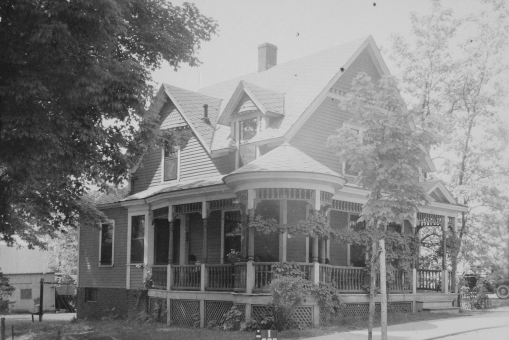
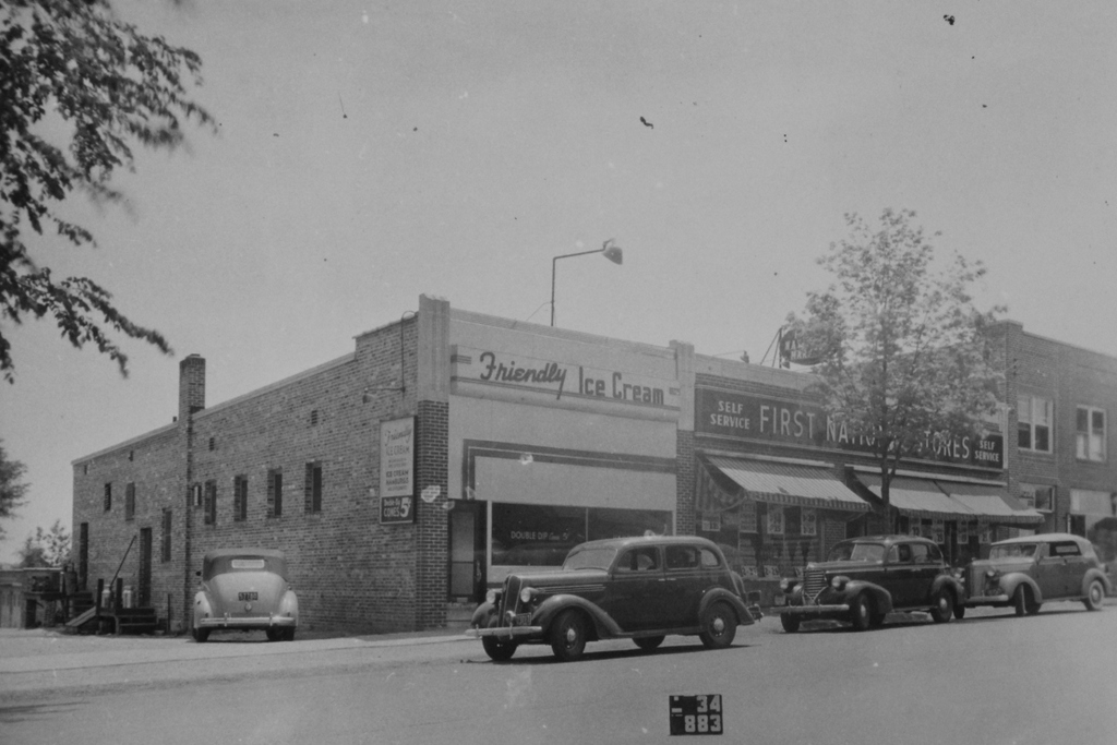
The house at 178 Boston Road in Springfield, around 1938. Image courtesy of the Springfield Building Department.
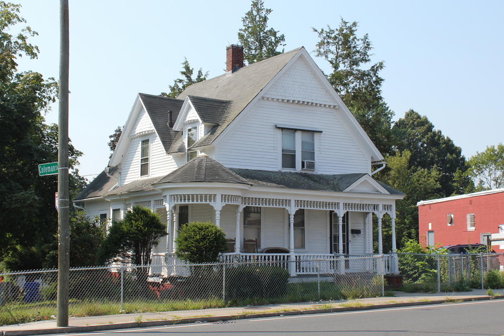
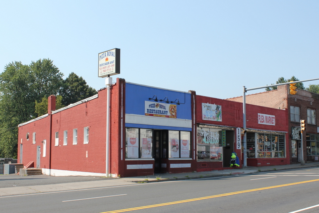
The scene in 2019:

As discussed in the previous post, Boston Road in Springfield was a sparsely-settled area prior to the turn of the 20th century. Most city maps throughout the 19th century show fewer than 20 houses along its entire 3.3-mile length from present-day Berkshire Avenue to the Wilbraham town line. This house, which was probably built around the mid-19th century, was one of those widely scattered houses, standing along Boston Road in what would eventually become the Pine Point neighborhood.

The early history of this house is difficult to trace because the outlying parts of the city did not have street numbers at the time, but a house appears near this spot on the 1835 map of Springfield. It was owned by John Butler, but it does not seem clear as to whether this is the same house from the first photo, because it is not shown on the 1855 county map. Probably the best indicator for the house’s age is its architecture, which features a blend of Greek Revival and Italianate elements. This style was particularly popular here in Springfield prior to the Civil War, so the house likely dates back to around the 1850s.

The first verifiable owner of this house was Ambrose O. Smith, who was living here by 1866. Born in Middlefield Massachusetts in 1829, Smith moved to Springfield in the mid-1860s, and during the 1870 census he was living here with his mother Nancy and his sister Mary C. Otis. He and his family lived here until at least 1872, but by 1873 he had moved to a house at 46 Walnut Street, where he was listed in the 1880 census as being a milk dealer. However, he continued to own this house for many years. He moved back here by the mid-1880s, and soon after he became one of the first landowners in this part of the city to subdivide his property into new streets and house lots.

Prior to the late 19th century, this area, which is located three miles east of downtown Springfield, was not a particularly desirable place to build houses. But, as the city grew in the post-Civil War era, developers began creating new residential neighborhoods to meet the increased demand for single-family homes. This was aided in part by the opening of trolley lines across the city, and by the 1890s one of these lines passed through modern-day Pine Point, connecting downtown Springfield to Indian Orchard.

Likely motivated by his land’s proximity to the trolley line, Ambrose O. Smith turned his Boston Road farm into a residential subdivision. His property extended behind this house as far north as Berkshire Avenue, and he also owned the land across the street on the south side of Boston Road, as far south as the North Branch of the Mill River. The 1899 city atlas shows a number of streets that had been laid out across his property, with Jasper Street on the north side, and Ambrose, Boyer, Coleman, Denver, Embury, and Falmouth (now Devonshire) streets on the south side. The land along these streets was divided into individual lots, although very few of them had been developed at this point. Aside from a handful of houses on Coleman Street, nearly all of these lots were still vacant in 1899.

Smith was still living in this house in 1899, but by the 1900 census he was on Lenox Street in Forest Park, and he died in 1904. The next long-term resident of this house was Joseph M. LaRiviere, who was living here as early as 1901. During the 1910 census he was 54 years old, and he lived here with his 44-year-old wife Evalena and their 23-year-old son Victor. Around this time, he sold postal cards in a shop on Main Street, while Evalena was a dressmaker and Victor worked as a clerk in Indian Orchard.

The LaRiviere family was still living here a decade later during the 1920 census, but by this point they had apparently divided the house into several different apartment units, because the census also shows two other families living here. They moved out soon after, though, because the 1921 city directory shows Joseph and Evalena living in a house on Douglas Street in the North End.

By the 1930 census, three families were renting apartments in this house, and their monthly rents ranged from $20 to $28. In one unit was Corinne LaTaille, a 36-year-old widow who lived here with her three children. Five years earlier, while living in a house on Denver Street, her husband Frank had committed suicide. According to contemporary newspaper accounts, this was likely caused by his recent two-month jail sentence for driving under the influence of alcohol, along with unspecified “family troubles.” The latter may have been related to the fact that, just two weeks after his death, Corinne gave birth to twin boys.

The other two families living here in 1930 included 44-year-old Charles and Annie Edson, who lived in an apartment with their six young children. Charles worked as a machine operator in a factory, and the family’s stay here was evidently short, because in 1929 they had been in a house on Denver Street, and within a few years they had moved elsewhere. The third tenant here in 1930 was George E. Miller, a 57-year-old radio mechanic who lived here with his 63-year-old wife Idella and their 29-year-old son George.

The first photo was taken in 1938, and two years later the 1940 census shows three more families living here. The rents had declined somewhat since 1930, likely because of the Great Depression, and all three tenants paid $20 per month. In one unit was John and Flora Kenney, in the second was Adele Rieck and her son Royal, and in the third was Arthur and Anna Allen and their young children Dorothy and George. Of all the residents here, Arthur was the only one who had been employed full-time in the previous year, earning $1,560 while working in a hotel laundry. During that same time, John Kenney worked for eight weeks as an inspector at the Armory, earning $203, while Royal Rieck earned $20 for two weeks as an elevator operator.

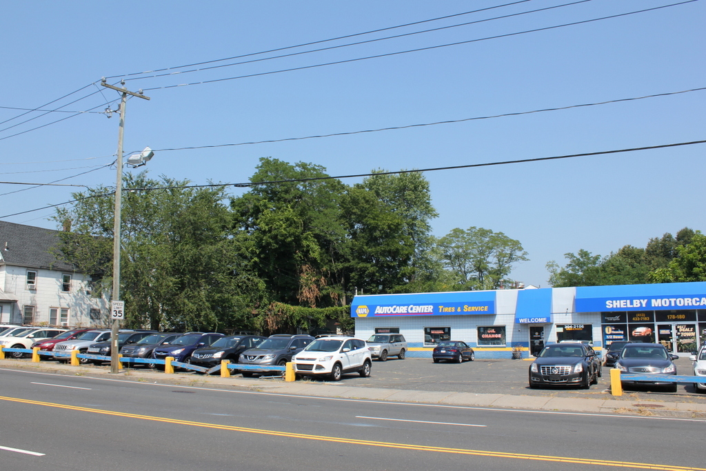
It is difficult to trace the subsequent fate of this house, but it appears to have still been occupied by residents as late as the early 1950s. However, by the mid-1950s this lot had become the junkyard of City Towing Service, although it seems unclear whether or not the house was still standing on the site. Then, in 1963 the property became the Pine Hill Motors car dealership. Its name has changed several more times since then, but this site continues to be a car dealership, and today the only surviving remnant from the first photo is the adjacent house on the far left at 168 Boston Road, which is still standing.

William G. Pierce House, Springfield, Mass

The house at 171 Boston Road, at the corner of Coleman Street in Springfield, on October 4, 1938. Image courtesy of the Springfield Building Department.

The house in 2019:

Today, Boston Road a busy four-lane road, lined with gas stations, restaurants, shopping plazas, used car dealerships, and other commercial development for most of its 3.3-mile length from Pine Point to the Wilbraham town line. However, as discussed in a previous post, this section of Springfield was lightly populated prior to the early 20th century. While passing through here in 1789, George Washington had described the area as “an almost uninhabited Pine plain,” and not much would change for another century, despite being located on the main route from Springfield to Boston. Much of this had to do with the poor quality of the soil, which made the land undesirable for farming. Distance was also a factor in this; modern-day Pine Point is about three miles from downtown Springfield, which made it impractical to commute into the city on a daily basis.

However, things had begun to change by the late 19th century, when a number of Boston Road landowners began subdividing their properties with new streets and house lots. This was likely spurred by the opening of a trolley line nearby on Berkshire Avenue, which linked downtown Springfield to Indian Orchard. Residents here could now commute to either location, or take connecting lines to other destinations, and by the early 20th century Pine Point had been transformed into a working class suburban neighborhood.

Over the years, nearly all of the old homes here on Boston Road have been demolished, either to clear the way for a new subdivision or to repurpose the land for commercial use. This house, located at the corner of Boston Road and Coleman Street, appears to be the oldest surviving house on Boston Road, and probably the only one that predates the development of the modern street grids.

It is difficult to determine the exact date when this house was built, in part because houses in the outlying areas of the city generally did not have street numbers during the 19th century. Various maps show houses in this vicinity as early as 1835, but it is not easy to tell exactly which houses were which. The documentation on the state’s MACRIS database lists it as having been built around 1882, based on atlases and directories of the period, and this seems like a plausible date, particularly since its Queen Anne-style design matches with architectural tastes of the early 1880s. In many ways, its design resembles a smaller version of the much larger Queen Anne houses that were built in the city’s McKnight neighborhood around the same time.

The first recorded resident of this house was William G, Pierce, who appears in the 1882 city directory as a merchant of the firm William G. Pierce & Co. However, he is not listed in either the 1881 or 1883 directories, so his stay here at this house may have been short. The next 15 years of this house’s history are unclear, but by 1897 it was owned by Julien W. Belanger, a merchant tailor who lived here with his wife Corinne, their five children, and a servant. His tailor shop was located on Main Street in downtown Springfield, and he likely would have used the new trolley line to commute to work. He and his family were living here as late as 1900, but by 1901 they had moved to Adams Street, and by 1904 they had moved to Canada, where both Julien and Corinne had been born.

By 1905, this house was being rented by Michael and Mary Byrne, who lived here with their four children. Like the Belangers, they were also immigrants, with Michael from Scotland and Mary from England. In city directories of the period, Michael is listed as a papermaker, although according to the 1910 census he was an automobile machinist. The census also lists their son Adam as having the same occupation, while their daughter Mary was a saleswoman at a department store, and their son Charles was an assistant bookkeeper at a department store.

The Byrne family left Springfield soon after the 1910 census, and by 1912 this house was owned by Albin M. Kramer, a civil engineer who had immigrated to the United States from Germany as a young child in 1872. His wife Rose was also an immigrant, from England, and they had married within a few years after her arrival in 1899. During the 1920 census, they were living here in this house with their children Alwin, Frederick, Vincent, and Marguerite, who ranged in age from 10 to 16.

Of the four Kramer children, Alwin would probably go on to have the most noteworthy career. He was 16 years old during the 1920 census, and a year later he graduated from Central High School. From there he went to the U. S. Naval Academy thanks to an appointment by Springfield’s Congressman Frederick H. Gillett, who was at the time the Speaker of the House. Alwin went on to have a long career in the Navy, but he is best remembered for his role in the events leading up to the attack on Pearl Harbor.

In 1939, Alwin became the head of OP-20-GZ, which was involved in intercepting, decrypting, and translating coded messages sent by the Japanese government. He was particularly busy in early December 1941, when his office decrypted a series of 14 messages sent to the Japanese embassy in Washington D.C. The last of these, sent in the early morning hours of December 7, instructed the Japanese ambassador to end diplomatic relations with the United States. However, it did not specifically indicate that an attack or a declaration of war was imminent, and there were a number of delays in Washington before this information was finally sent to Pearl Harbor, arriving several hours after the attack.

Alwin Kramer would go on to serve with distinction in World War II, and was eventually promoted to captain. However, his actions in early December, and those of his colleagues and superiors, fell under increased scrutiny after the war, eventually leading to a Congressional inquiry in 1946. The hearings were likely politically motivated, in an attempt by Republicans to discredit the Roosevelt and Truman administrations, but Captain Kramer did himself no favors with his confusing and often contradictory testimony, and he ended up retiring from the Navy by the end of the year. Nonetheless, he was never formally assigned any blame, and his wartime promotions suggest that his superiors in the Navy did not find fault in his actions. He died in 1972 at the age of 69, and he was buried in Arlington National Cemetery.

In the meantime, Kramer’s family continued to live here in his childhood home until around 1929, although by the 1930 census his parents and two younger siblings were living in a house at 127 Massachusetts Avenue. The next long-term residents here at 171 Boston Road were Walter and Mazie Spickler, who were here as early as 1933. They were both in their mid-40s at the time, and they lived here with their son George and his wife Edna. George and Edna subsequently moved to a house of their own on nearby Denver Street by 1937, but Walter and Mazie were still here on Boston Road when the first photo was taken in 1938. According to the 1940 census, they paid $37 per month in rent, and Walter earned $1,560 per year as a fireman at a cotton mill.

Walter Spickler died shortly after the census was taken, in September 1940, at the age of 54. Mazie continued to live here for at least a few more years, and the 1944 city directory shows her working as an inspector at Westinghouse. However, she moved by the following year, because the 1945 directory shows Franklin and Virginia Lewis living here. At the time, Franklin was working as a collector for the Springfield Union newspaper, and he later became the circulation supervisor for the Springfield Newspapers. He lived here until his death in 1969, at the age of 64. It seems unclear as to how much longer Virginia lived here, but she ended up outliving Franklin by more than 40 years, before her death in 2010 at the age of 104.

Today, more than 80 years after the first photo was taken, remarkably little has changed in this scene. The property is now surrounded by a chain link fence, and the house appears to have a different paint scheme, but otherwise its exterior looks essentially the same as it did in the 1930s. The shed in the backyard on the far left is also still there, as is the brick building on the far right side. Although mostly hidden by trees in the first photo, this building was here in the 1930s, and it is best known as the site of the first Friendly’s restaurant, which opened here in 1935. In general, very few historic buildings have survived the various waves of development along Boston Road, but this house stands as an unusual reminder of what Springfield’s main commercial thoroughfare once looked like.

Stetson Hardware, Springfield, Mass

Stetson Hardware at 162-164 Boston Road in Springfield, on October 12, 1938. Image courtesy of the Springfield Building Department.

The scene in 2019:

This building was constructed around 1919, at the corner of Boston Road and Jasper Street in Springfield’s Pine Point neighborhood. At the time, Pine Point was in the process of being developed as a residential suburb, and this section of Boston Road was becoming its main commercial center. This was among the first commercial buildings in this area, and it was built of wood, unlike the brick ones that would be built across the street from here in the 1920s and 1930s.

The building originally consisted of two separate storefronts, with the one on the left at 162 Boston Road, and the one on the right at 164 Boston Road. In the fall of 1938, when the first photo was taken, the storefront on the left was vacant and available for rent, as indicated by the signs in the windows. On the right side, this storefront was occupied by Stetson Hardware, which was owned by Louis C. Stetson. During the early 1930s he had worked as a shipping clerk, but around 1936 he went into business for himself, with a hardware store on Orange Street. He moved his store here to Boston Road around 1937, and according to the sign in the photo he sold paints, varnish, glass, kitchenware, and novelties. However, his business evidently did not last, because it last appears in city directories in 1940, and by 1941 he was listed as working in a warehouse in West Springfield.

By the late 1940s, Stetson’s former store had become A. C. Winckel, a paint store owned by Adam C. Winckel. He died in 1951 at the age of 48, but his widow Ada carried on the business for many years, until at least the mid-1960s. Then, at some point in the second half of the 20th century, the building was heavily altered with a new front facade, along with vinyl siding on the rest of the exterior. Overall, though, it is still recognizable from the first photo, and it stands as one of the oldest surviving commercial buildings in Pine Point.

Boston Road from Coleman Street, Springfield, Mass

Looking west on Boston Road from near the corner of Coleman Street in Springfield, around 1924. Image from Catalogue of the Flowering Plants and Ferns of Springfield Massachusetts (1924).

The scene in 2019:

The primary subject matter of the first photo was intended to be the tree in the foreground, which is identified as Acer rubrum L. var. tridens Wood, a rare variety of red maple. However, the photo also captures a rare view of Boston Road as it appeared nearly a century ago, prior to its extensive commercial development. The view faces west along Boston Road from the corner of Coleman Street, right in the midst of what would soon become the center of the Pine Point neighborhood.

Throughout most of the 19th century, this section of Springfield was only sparsely settled, with the 1870 city map showing fewer than 20 houses along the entire 3.5-mile stretch of Boston Road from Berkshire Avenue to the Wilbraham town line. This began to change by the 1890s, though. Likely motivated by the recently-opened trolley line on nearby Berkshire Avenue, landowners in present-day Pine Point began subdividing their properties with new streets and house lots. By 1899 there were at least six houses on Coleman Street, and over the next two decades there would be further development, particularly on Denver and Jasper Streets.

Overall, though, the neighborhood maps of the early 20th century show far more vacant lots than houses, and it would take many years before most of the streets were fully developed. The first photo was taken during this period, when even Boston Road, the main thoroughfare through Pine Point, still had many empty lots and hardly any commercial development.

There are only two houses visible in the first photo. On the left, at the southwest corner of Boston Road and Coleman Street, is one of the oldest surviving houses in the area. It was built sometime around 1882, predating the modern street grid that was added about a decade later, and during the early 1880s it was the home of merchant William G. Pierce. Subsequent owners included tailor Julian Belanger, and by the time the first photo was taken in the early 1920s it was the home of civil engineer Albin M. Kramer, his wife Rose, and their three children.

The house on the right, at 168 Boston Road, is somewhat newer. It was built sometime between 1899 and 1910, and it appears to have been constructed as a two family home. During the early 20th century it had a number of different tenants, most of whom only stayed for a few years. Among these were my great grandparents, Frank and Julia Lyman, who lived here from about 1915 to 1917. Frank was a machinist who was originally from Wilbraham, and Julia grew up in New York City, where she worked for the New York World newspaper. They lived in the New York area for the first few years of their marriage, but they moved to Springfield around 1915. At the time they had two young children, Elizabeth and Edith, and their third child Evelyn, my grandmother, was born here in this house in 1917. Soon after, the family purchased a house nearby at 37 Coleman Street, and they were living there when this photo was taken at the end of their street a few years later.

By the 1920 census, one unit in the house at 168 Boston Road was occupied by painter Raymond L. Taft, his wife Alice, and their three young children. The other unit was the home of carpenter Frank E. Bowen, and his wife Edith, who had three children of their own. However, neither family appears to have remained here for very long; Alice Taft died in 1921, and by the following year Raymond was living elsewhere in Pine Point. The Bowen family had also moved out by then, and during the 1920s the house appears to have changed tenants very frequently, with most only appearing here in the city directory for one year.

Within just a few years after this photo was taken, this section of Boston Road developed into the commercial center of the Pine Point neighborhood. At some point around the late 1920s, the house on the right was altered with the addition of two storefronts, one of which was the home of Nora’s Variety Store for many years. Across the street from there, on the left side of the scene, a row of commercial buildings was constructed in the late 1920s and early 1930s. The easternmost of these, visible just beyond the house on the far left, is best known as the location of the original Friendly’s restaurant, which opened there in 1935.

Today, nearly a century after the first photo was taken, very little in this scene has remained the same. The red maple is long gone, and all of the vacant lots here have since been developed. Boston Road is now a four lane road and one of the main east-west routes through the city, and it is almost entirely commercial, with very few remaining houses. However, both of the houses from the first photo have managed to survive, although the one on the left was heavily altered by the late 1920s storefront addition. The one on the right has remained much better preserved, though, and it stands as a rare Victorian-style house in an otherwise predominantly 20th century neighborhood.

Mascaro’s Cafe, Springfield, Mass

Mascaro’s Cafe at 752 Boston Road in Springfield, on March 21, 1939. Image courtesy of the Springfield Building Department.

The scene in 2019:

This lot at the northeast corner of Boston Road and Harvey Street has been developed since at least 1910, when a house appears here on that year’s city atlas. By the mid-1910s, the property was owned by Pietro Mascaro, an Italian immigrant who lived here with his wife Lena and their sons Antonio and Frank. He died in 1916, but the family continued to own this property for many years, and they operated several different businesses here.

By the time the first photo was taken in 1939, the property had been expanded far beyond the original house, which is barely visible in the distance on the left, behind the Coca Cola sign. At some point around the 1920s, two storefronts were added to the front of the house, along with a gas station on the other side of it, which was run by Frank Mascaro. Then, probably sometime in the late 1920s or 1930s, this section was built further to the east of the house, at the corner of Sewall Street. Unlike the earlier storefronts on the far left of the first photo, which were built up to the sidewalk, most of this section was set back from the road. This was presumably done to allow room for parking, reflecting the growing importance of automobiles by this time.

Although there are no names of businesses visible in the first photo, this section of the building appears to have had at least two different occupants at the time. On the far right side is some sort of a convenience store, with advertisements for Philip Morris, Salada Tea, Orange Kist, and other products visible near the entrance. To the left of it, marked by a Hampden Ale sign, is a bar, which is also variously described as a cafe, a dance hall, a roadhouse, and a tavern in city directories and newspapers of the period. It had been in business as early as 1933, in the final year of Prohibition. Antonio Mascaro received a beer license in May of that year, a little over a month after the passage of the Cullen–Harrison Act, which legalized low-alcohol beer.

Just beyond the building on the far right side of the photo is the house at 22 Sewall Street. At the time it was the home of Antonio Mascaro, his wife Josephine, and their children Rosemary and Peter. He operated the bar, which came to be known as Mascaro’s Cafe, for many years, until his death in 1957 at the age of 67. His son Peter then took over the business and ran it for more than 25 years, before selling it to Mattie’s Cafe in 1984.

Today, more than 80 years after the first photo was taken, this scene has undergone considerable changes. On the far left, the old house has long since been demolished, along with Frank Mascaro’s gas station and the two storefronts, and they were replaced by a more modern gas station. The former Mascaro’s Cafe building in the center of the scene is still standing, and it is still in use as Mattie’s Cafe, although it looks very different from its appearance in 1939. It is difficult to tell exactly when these renovations occurred, but they likely happened around the mid-20th century, and the work included bricking up the windows on the left side, along with adding a new brick facade to the front of the building. Overall, the only building that remains largely the same from the first photo is Antonio Mascaro’s former house on Sewall Street, which still stands on the far right side of the 2019 photo.

First Friendly’s Restaurant, Springfield, Mass

The original home of Friendly Ice Cream, at 161 Boston Road in Springfield, around 1938-1939. Image courtesy of the Springfield Building Department.

The scene in 2019:

The first photo was taken only a few years after S. Prestley and Curtis Blake opened the first Friendly Ice Cream location here in Springfield’s Pine Point neighborhood. In 1935, the two brothers, aged 20 and 18, respectively, borrowed $547 from their parents and opened the ice cream shop, charging 5 cents for a two scoop cone as the sign on the side of the building indicates. The business soon proved to be popular, and in 1940 they opened a second shop in West Springfield. By the early 1950s, they had 10 locations in the area, and when the Blake brothers sold the company in 1979, it had grown to over 500 restaurants. Today, the company operates 380 restaurants along the east coast from Maine to Florida.


The buildings in the first photo were probably built in the 1920s or early 1930s, when Pine Point was growing as a middle class residential neighborhood. As seen here and in this earlier post, these commercial buildings are all still standing, but the change in use has reflected some of the changes in the neighborhood over the years. The original Friendly’s has long since closed, and its storefront is now a pizza restaurant, and to the right the First National supermarket has been divided into two smaller storefronts. Directly across the street from here was Nora’s Variety Store, a Pine Point fixture for many years that, likewise, has closed, and now stands vacant.