Hotel Windham, Bellows Falls, Vermont

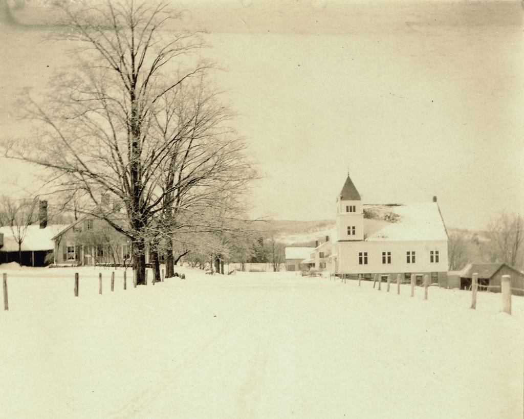
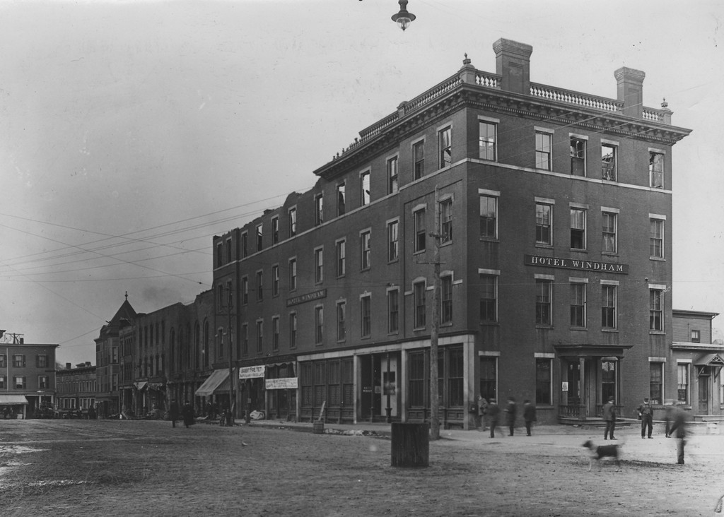
The Towns Hotel, later known as the Hotel Windham, on the east side of the Square in downtown Bellows Falls, in the aftermath of an April 12, 1899 fire. Image courtesy of the Rockingham Free Public Library.

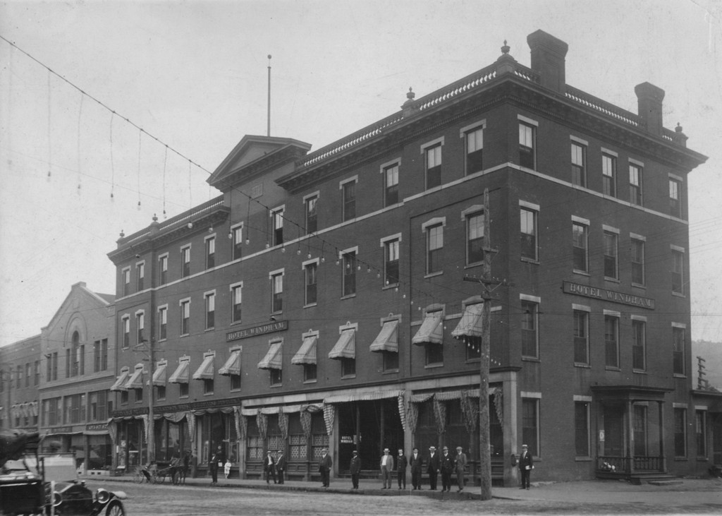
The rebuilt hotel around 1900-1912. Image courtesy of the Rockingham Free Public Library.

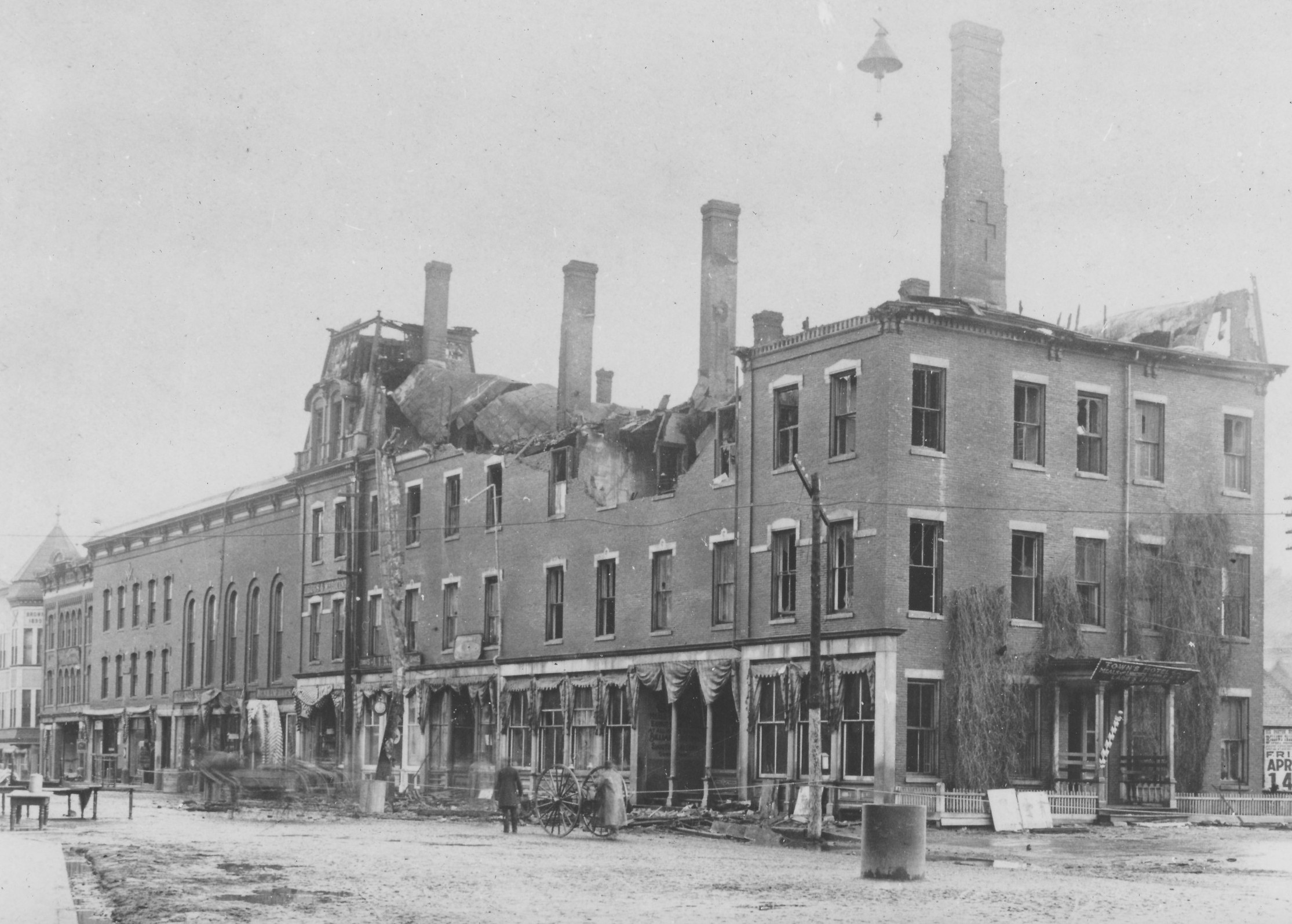
The hotel in the aftermath of a March 26, 1912 fire. Image courtesy of the Rockingham Free Public Library.

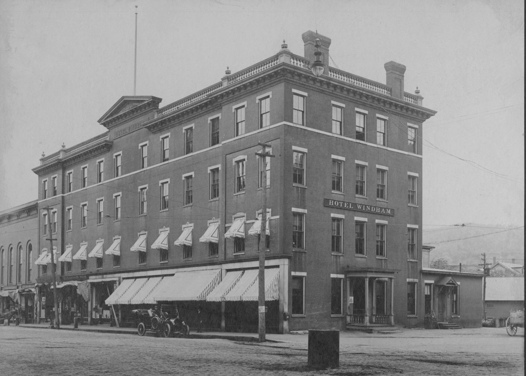
The hotel around 1913-1920. Image courtesy of the Rockingham Free Public Library.
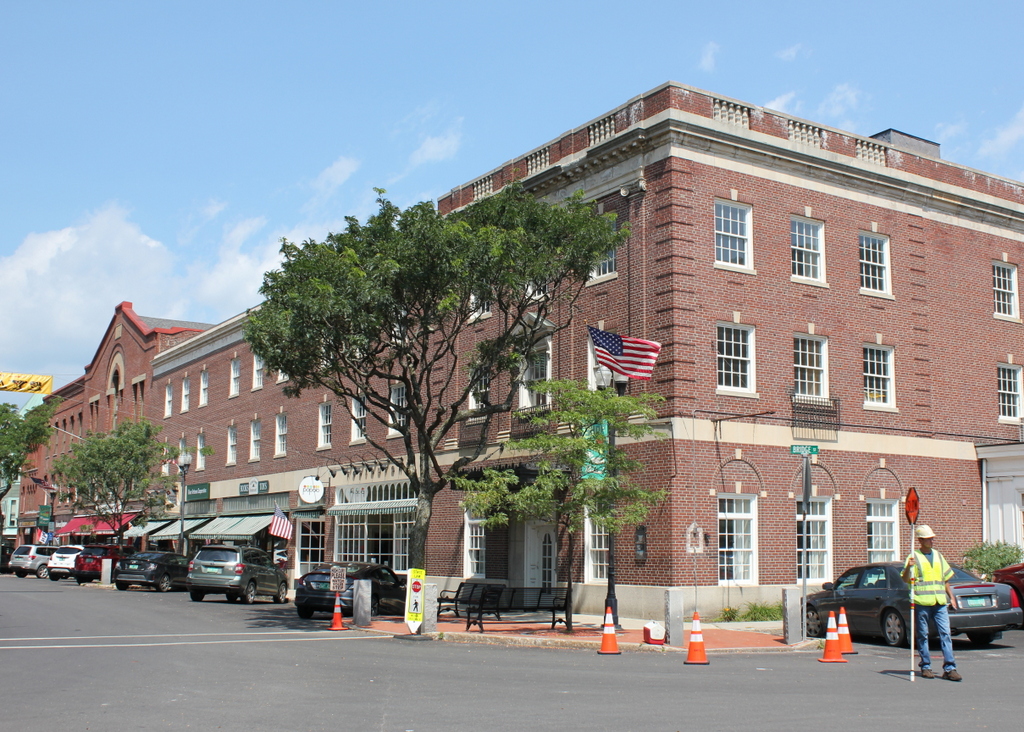
The scene in 2018:

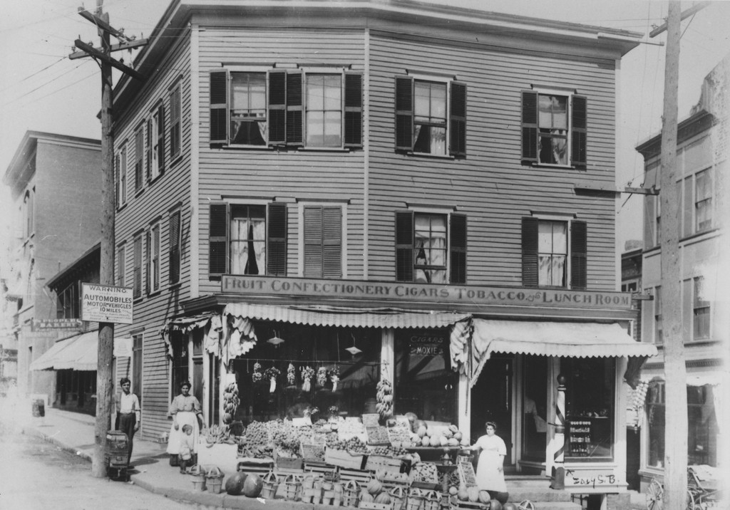
This spot here, at the southeast corner of the Square in Bellows Falls, has been the site of a hotel since the early 19th century. During this time, though, these hotels have been affected by a series of devastating fires. The first hotel was built here in 1816, and it was originally known as Webb’s Hotel, although it later became the Bellows Falls Stage House. This building burned in 1860, and in 1873 a new one, Towns Hotel, was built here on the site.

The Towns Hotel, named for owner Charles W. Towns, sustained heavy damage in a fire on April 12, 1899. Guests in the building had begun smelling smoke around 7:30 in the evening, but the fire smoldered for more than an hour before it was located under the fourth floor hallway. At first, it seemed as though it had been extinguished, but it had begun spreading into the empty space under the roof, and it ultimately set the upper floors ablaze. As shown in the first photo, the fourth floor was almost completely destroyed, and the third floor and parts of the second floor were completely gutted. The ground floor was largely untouched by the fire itself, but the stores here were flooded by all of the water that was poured into the building.

Following this fire, the hotel was rebuilt and expanded as the Hotel Windham, with a total of 75 guest rooms by the time the second photo was taken in the early 1900s. Then, it burned again in the early morning hours of March 26, 1912. The fire started in the adjacent Union Block, which is visible on the far left side of the second photo. It was evidently caused by a discarded cigarette, and it completely gutted the Union Block while also spreading to the Hotel Windham on the right and the Arms Block on the left.

According to early estimates, the total damage to the three buildings was about $150,000 to $200,000, and it displaced about 20 businesses and professional offices. There were 30 guests in the hotel at the time of the fire, but they were all evacuated with the help of the hotel employees, and there were no fatalities from any of the buildings. Part of the challenge for the responding firemen was the cold temperatures, which reached as low as ten degrees below zero, making it difficult to get water to the scene. By the time the fire was extinguished, the burned-out ruins were covered in ice.

The third photo was probably taken soon after the ice melted. No work had been done on the buildings yet, although several of the stores had already posted signs above their doors. One of the signs, above the Collins & Floyd jewelry store, informs customers of their temporary location, and another, above the Richardson Brothers shoe store, reads “Biggest Fire Yet. Particulars and Prices Later.”

All three of the damaged buildings were subsequently rebuilt. Because of the extent of its damage, the Union Block was completely reconstructed, becoming the three-story, gable-roofed building on the left side of the last two photos. The Arms Block to the left of it had comparatively less damage, and it was repaired along with the Hotel Windham. The fourth photo was probably taken soon after this work was completed, and it shows that the exterior of the repaired hotel was nearly identical to its appearance before the fire.

The building stood here for the next two decades, but on April 5, 1932 the hotel was again destroyed by a catastrophic fire. It started a little after midnight, apparently in an unoccupied room on the second floor, and it subsequently spread throughout the entire building, leaving little standing except for some of the brick exterior walls. All 44 guests were able to leave safely, though, most with their belongings, and the fire was successfully contained to just the hotel, preventing it from spreading to the neighboring buildings.

This time, the remains of the old 1873 building were completely demolished, and a new, somewhat smaller hotel was built on the site. This three-story brick, Colonial Revival-style hotel opened just over a year later, on May 1, 1933, and it is still standing here on this site. It remained the Hotel Windham for many years, although it later became the Andrews Inn by the 1970s.

Today, the Hotel Windham remains an important feature in the center of Bellows Falls. It is no longer used as a hotel, but it still features stores on the ground floor. The exterior remains well-preserved in its early 1930s appearance, and it recently underwent a restoration. The other buildings further to the left of the hotel are also still standing, including the Arms Block, which dates back to before the first photo was taken. Today, all of these buildings here are part of the Bellows Falls Downtown Historic District, which was added to the National Register of Historic Places in 1982.

Baldasaro’s Fruit Market, Bellows Falls, Vermont

The building at the northern end of the Square, between Rockingham and Canal Streets in Bellows Falls, around 1904-1914. Image courtesy of the Rockingham Free Public Library.

The scene in 2018:

During the early 20th century, downtown Bellows Falls suffered a series of devastating fires that destroyed many of the 19th century buildings here at the Square. Throughout this time, though, this modest wood-frame commercial block has survived largely unscathed, with few significant changes since the first photo was taken more than a century ago.

The building’s origins date back to around 1820, although it was heavily reconstructed around 1890, including the addition of a third floor. By about the turn of the 20th century, the storefront was occupied by Baldasaro’s Fruit Market, as shown in the first photo. The market was run by Pasquale “Patsy” Baldasaro, an Italian immigrant who came to the United States as a teenager in the mid-1880s. He spent some time working as a foreman for the Boston & Maine Railroad, but he subsequently came to to Bellows Falls, where he opened a fruit market on Canal Street before moving his store to this location.

Baldasaro ran the business until the early 1910s, when he sold it to two of his clerks, and he died in 1921 at the age of 48. However, he was still remembered many years later, and his store was mentioned in the 1958 book History of the Town of Rockingham Vermont, which provides the following reminiscence:

At the north end of the Square, now occupied by the Army & Navy Store which opened there in 1946, was once the fruit store where Patsy Baldasaro hung out great bunches of bananas, set out baskets of oranges and apples, watermelons and coconuts and whose peanut roasting maching [sic] whistled cheerfully on the edge of the sidewalk. Patsy was a well known figure in town for many years and every housewife rallied to his long-drawn call of “ba-na-nas, o-ran-ges,” as he rode his cart through the streets, seated like a Gargantua, his immense body making it a hazardous adventure to get up and down from his high perch. Youngsters saved their pennies to buy an orange as big as a croquet ball for a nickle and the last thing on Saturday afternoons, thrifty mothers could buy eighteen dead ripe bananas for a quarter. The pleasant ghost of Patsy still rides the summer streets along with the sprinkling cart, the ice wagon and the hot smell of tar sidewalks on a July day. His broad face always smiled but his whip was ready to reach out and flick the bare legs of any youngster who sneaked up behind to snitch a loose banana or coconut.

As mentioned in that excerpt, the building was used as an army and navy store during the mid 20th century, and since then it has seen a variety of other commercial tenants, including, in recent years, a cycling studio and an antique shop. Then, in 2017 it was purchased by Rockingham Roasters, and over the past few years the building has undergone a major restoration, including repairing the foundation and gutting the interior. The first photo was taken during the summer of 2018 in the midst of this work, and the project is still ongoing, although the coffee shop is projected to open at some point this year.

Overall, the historic building has remained well-preserved on the exterior, and the only significant difference since the early 20th century is the altered storefront on the ground floor. Several of the surrounding buildings are also still standing from the first photo, including the old fire station on the far left, which was built in 1904. Today, these buildings, along with the rest of the historic properties in the area, are now part of the Bellows Falls Downtown Historic District, which was added to the National Register of Historic Places in 1982.

Railroad Station, Bellows Falls, Vermont

The railroad station on Depot Street in Bellows Falls, around the late 1800s. Image courtesy of the Rockingham Free Public Library.

The scene in 2018:

The village of Bellows Falls, which is located within the town of Rockingham, developed into an important transportation crossroads during the late 18th century. Here, the Connecticut River drops 52 feet as it passes through a narrow gorge. This was an impediment to river navigation, requiring a canal here to bypass the falls, but the width of the gorge also made it an idea spot for a bridge. For most of the 18th century, there were no bridges over the Connecticut River at any point along its 400-mile course, but the first opened here at Bellows Falls in 1785. This made it easier to travel between Vermont and New Hampshire, and it was an important link on the trade routes from Boston to Montreal.

With the development of railroads during the first half of the 19th century, Bellows Falls became the junction of several different railroads. The first to arrive were the Sullivan County Railroad and the Cheshire Railroad, which opened in 1849. At the time, though, there was no railroad bridge across the river, so passengers bound for Bellows Falls had to disembark across the river in Walpole, New Hampshire and cross the covered bridge on foot. Later in 1849, the Rutland and Burlington Railroad was opened to Bellows Falls, followed in 1851 by the Vermont Valley Railroad.

The first railroad station here in Bellows Falls was built on this site, on a triangular plot of land just south of where the four railroads converge. The railroads formed an “X” here, with the Vermont Valley Railroad heading southwest, on the far left side of the scene; the Cheshire Railroad heading southeast, on the far right side; the Sullivan County Railroad to the northeast; and the Rutland and Burlington Railroad to the northwest. This original station was used for a few years, but around 1852 it was replaced by a more substantial brick building, which is shown here in the center of the first photo.

Over the years, these various small railroads were eventually consolidated into much larger ones through a series of mergers and leases. By the 1870s, all but the Cheshire Railroad were controlled by the Central Vermont Railroad, although the Central Vermont subsequently leased the Sullivan County and Vermont Valley to the Boston & Maine Railroad by the early 1880s, and ended its own lease on the Rutland Railroad in 1896. Then, in 1900, the Boston & Maine acquired the Cheshire, which gave them control over most of the rail traffic in Bellows Falls. However, the Central Vermont retained trackage rights through Bellows Falls, and continued to operate trains here.

At some point around the turn of the 20th century, the railroad station was evidently remodeled, as period postcards show it with a very different roof than the one in the first photo. However, the old station remained in use until 1921, when it was destroyed by a fire on a cold December night. The fire started in the restaurant kitchen, and within a half hour the building was gone, thanks in part to the interior wood paneling that helped to fuel the flames. In addition, the responding firefighters had to contend with sub-zero temperatures and 60-mile-per-hour winds. One of the nearby hydrants was completely frozen, and by the time they were able to get water flowing from another hydrant it was of little use; there was no saving the station at that point, and, in any case, the strong winds only blew the water back toward the firefighters.

The present-day railroad station was completed on the same site in 1923, although it is a much more modest building than its predecessor, with only one story topped by a very low roof. It continued to be used by passengers throughout the next few decades, but inter-city rail travel saw a steep decline across the country after World War II. With more travelers preferring automobiles or airplanes, railroads steadily shrank their passenger service. The last privately-run passenger train that stopped here in Bellows Falls was the Montrealer, which ceased in 1966. However, the service was subsequently revived after Amtrak was created, and the Montrealer returned to Bellows Falls again in 1972.

Today, nearly a century after this building opened, it remains in use as a railroad station, although there is far less passenger traffic than there had been here in the 1920s. The Montrealer was eventually replaced by Amtrak’s Vermonter, which runs one northbound and one southbound train each day between St. Albans, Vermont and Washington, D.C. These two daily trains are the extent of passenger rail service in Bellows Falls today, but the historic station still stands here as reminder of the village’s railroad legacy. Another historic building here is the Railway Express Agency building, on the far right side of the scene. Built around 1880, it is the only surviving building from the first photo, and both it and the railroad station are now part of the Bellows Falls Downtown Historic District, which was added to the National Register of Historic Places in 1982.

Church Street, Bellows Falls, Vermont

The view looking north on Church Street from the corner of Westminster Street in Bellows Falls, around the early 1900s. Image courtesy of the Rockingham Free Public Library.

The scene in 2018:

As discussed in more detail in the previous post, the house on the left side of this scene was once the home of Hetty Green, a Gilded Age financier who was well-known for both her business acumen and her extreme frugality. The house itself dated back to 1806, when it was the home of merchant William Hall, and it was later owned by Nathaniel Tucker, who operated the nearby Tucker Toll Bridge over the Connecticut River. In 1879, Tucker’s grandson, Edward Henry Green, purchased the house, and he lived here with his wife Hetty and their two children.

The first photo was probably taken at some point during their ownership of the house, prior to Hetty’s death in 1916 at the age of 81. By then, she had accumulated a fortune of over $100 million, equivalent to over $2 billion today, which made her the richest woman in the country at the time. However, she lived a very modest lifestyle, wearing plain, old clothing and eating only inexpensive food, and reportedly foregoing both heat and hot water here in her house.

Just to the right of the Green house in the first photo is another brick house, which was the home of flour mill operator Edward Arms. He died in 1900, but the house remained in his family for many years. The 1910 census, which was probably done around the same time that the first photo was taken, shows his widow Josephine living here with their daughter Caroline, who was 31 years old. Caroline continued to live here until at least the early 1950s, although in her later years she apparently used it primarily as a summer residence.

On the far right side of the scene is the First Baptist Church of Bellows Falls, which stands at the top of the hill at the corner of Church and School Streets. The congregation was established in 1854, and this building was completed in 1860. It originally featured a tall, narrow spire atop its roof, and throughout the 19th century it was referred to as the needle spire. However, the building was renovated in 1899, including the removal of the spire and an addition to the right side, including a new tower on the corner. The first photo was probably taken soon after this work was completed, as it shows the church in its altered appearance.

Today, more than a century after this photo was taken, much of this scene has changed. Hetty Green’s daughter Sylvia owned the house on the left throughout the early 20th century, but in 1940 she gave the property to the town. The old house was subsequently demolished, and the site is now a bank. The Arms house next door is also gone, and in its place is Hetty Green Park. As a result, the Baptist church is the only surviving building from the first photo. Its exterior is not significantly different, although the tower is hidden from view by the trees, and it remains in use by the same congregation that constructed it more than 150 years ago.

Hetty Green House, Bellows Falls, Vermont

The Hetty Green House at the corner of Church and Westminster Streets in Bellows Falls, around 1900-1910. Image courtesy of the Library of Congress, Detroit Publishing Company Collection.

The scene in 2018:

It is hard to tell from its appearance, but this house was the home of the wealthiest woman in America when the first photo was taken at the turn of the 20th century. Throughout her life, even after she had amassed a fortune worth many millions of dollars, Wall Street financier Hetty Green lived a very frugal—and some would say miserly—lifestyle. She wore plain, old clothing, ate inexpensive meals, and shunned most luxuries, supposedly even heat and hot water.

Her house here in Bellows Falls was another example of her modest living. Although certainly a fine house in its own right, it was hardly befitting of a Gilded Age tycoon, especially considering the lavish mansions that many of her contemporaries, most notably the Vanderbilts, were constructing in New York, Newport, and other fashionable places.

The house itself was situated at the corner of Church and Westminster Streets, just to the south of the center of Bellows Falls. It was built in 1806 by William Hall, a wealthy local merchant in the firm of Hall & Green. Hall was also involved in politics, serving on the governor’s council, in the state legislature, and as Vermont’s sole delegate to the 1814-1815 Hartford Convention. He lived here in this house until his death in 1831, at the age of 57, and the house was subsequently purchased by Nathaniel Tucker, the owner of the nearby Tucker Toll Bridge over the Connecticut River.

Nathaniel Tucker had connections to William Hall, as his daughter Anna was married to Hall’s former business partner, Henry Atkinson Green. Their son, Edward Henry Green, would eventually become a successful Boston merchant, and in 1867 he married Henrietta “Hetty” Robinson, the wealthy heiress of a New Bedford whaling family. Then, in 1879 he purchased his grandfather’s old house here in Bellows Falls, and moved his family into it.

Hetty Green was 33 years old when she married Edward, and she was already extremely wealthy, having inherited about $6 million after her father’s death two years earlier. However, her fortune would continue to grow thanks to her shrewd investment strategies, and she came to be known as the “Witch of Wall Street”at a time when high finance was almost exclusively a male profession. By the time she died in 1916 at the age of 81, her estate was valued at over $100 million, equivalent to over $2 billion today, making her the richest woman in America at the time.

Hetty and Edward had two children, Ned and Sylvia, who were about 11 and 8 years old, respectively, when their father purchased this house. During his childhood, Ned became the subject of one of the most famous examples of his mother’s frugality after he injured his knee. Wanting to avoid paying for a doctor, Hetty instead tried to treat him herself. However, infection set in and the leg became gangrenous, and it ultimately had to be amputated.

In adulthood, Ned spent his money much more freely than his mother had. He owned a 225-foot steam yacht, and he built a mansion on Buzzards Bay in Massachusetts, which featured his own private airfield and radio station. In addition, he was an avid collector of coins and stamps, and at one point his collection included all five examples of the extremely rare 1913 Liberty Head nickel, along with the only known sheet of the famous Inverted Jenny postage stamp. Ned also played an important role in historic preservation when, in the 1920s, he purchased the former whaling ship Charles W. Morgan, which had once been a part of his maternal grandfather’s whaling fleet. He put it on display at Round Hill, and after his death it was acquired by Mystic Seaport in Connecticut, where it remains as the last surviving 19th century whaling ship.

Ned’s sister Sylvia, however, was much more like their mother when it came to saving money. In 1909 she married Matthew Wilks, a member of the Astor family who was 25 years her senior, although her mother insisted that they sign a prenuptial agreement to prevent Wilks from inheriting Sylvia’s money. Neither Sylvia nor her brother had any children, and after Ned’s death in 1936 Sylvia inherited his portion of the estate, as a result of a similar prenuptial agreement that he had signed with his wife, Mabel Harlow. Later in life, though, Sylvia became both miserly and reclusive, and her last public appearance was in 1937, when she testified in court to prevent Mabel from receiving a greater share of Ned’s fortune.

Upon her death in 1951 at the age of 80, Sylvia was described by Life magazine as “a friendless, childless, cheerless old woman, abjectly poor in everything but money and devoted only to the preservation of the great Green fortune.” Her net worth at the time was around $95 million, nearly $1 billion today, but with no children or other close relatives she left nearly all of her money to 63 different charities, including a variety of churches, libraries, and hospitals. Among these were the Rockingham Memorial Hospital and the Immanuel Episcopal Church, both of which are located here in Bellows Falls.

In the meantime, the old house here on Church Street in Bellows Falls remained in the Green family until 1940, although Sylvia does not appear to have spent much time here in her later years. By this point the house was in need of repairs, so rather than restoring it, Sylvia had the house demolished, and then gave the property to the town. The property subsequently became a parking lot and a park, which was named Hetty Green Park.

Today, park is still here, on the far right side of the scene, but the actual site of the house is now a bank, which was constructed in 1960. It was originally the Vermont Bank & Trust Company, but after a series of mergers in the late 20th century it is now owned by TD Bank, which continues to operate it as a branch. The bank building certainly does not have the same architectural or historic significance that the old house had, although in retrospect it seems only appropriate that Hetty Green’s former property would be used as a place where large amounts of money are kept.

Fort Bridgman Road, Vernon, Vermont

The view looking north on Fort Bridgman Road, toward the intersection of Pond Road in Vernon, probably sometime around 1907-1918. Image from author’s collection.

The scene in 2018:

The town of Vernon is located in the extreme southeast corner of Vermont, and for much of its history it was small, with a population that consistently hovered around 600 to 800 people throughout the 19th and early 20th centuries. Most of this population was dispersed across 20 square miles, so Vernon never had a densely-settled town center, but the main village in town was here along Fort Bridgman Road, near the corner of Pond Road.

During the 19th century, this area was the commercial hub of the town, with an 1869 map showing a sawmill, blacksmith’s shop, carpenter’s shop, lumber yard, a church, and a building that was occupied by a store, post office, and hotel. There were also about a dozen houses clustered in the immediate vicinity, and the railroad passed through here along the Connecticut River, although the depot itself was located a little further to the north of here.

The first photo was taken at some point in the early 20th century, evidently soon after a snowstorm. It is a real photo postcard, meaning that it is a photograph that was developed directly onto postcard stock, instead of being mass-produced via printing. The photo is undated, but the markings on the reverse suggest that it was taken at some point between 1907 and 1918. On the reverse is a message written by a woman named Ethel Davis, who apparently also took the photo. It reads:

Dear Aunt Jessie,

I thought you probably would like to hear from me as I am up in Vt. with a friend. This is not a very good picture as we take them our selves. It is quite lonsome up here. This is Main St Vernon, Vt.

There is lots of snow up here. I am not very lonsome. But do wish I were home. From your niece Ethel Davis.

The photo shows the view looking north toward the town center, with the Connecticut River just out of view on the far right, and the railroad on an embankment to the left. The most visible building in this scene is the Vernon Union Church, on the right side of the road. It was completed in 1900, and it replaced an earlier one on the same site, which had burned after being struck by lightning a year earlier. Beyond the church is a building that appears to have been the store/post office/hotel from the 1869 map, and on the left side of the road is a house that probably dates to the first half of the 19th century. It appears on the 1869 map as well, when it was listed as the home of Mrs. R. S. Bryant.

In more than a century since the first photo was taken, Vernon has undergone some major changes, the most significant of which was the Vermont Yankee nuclear power plant, which operated in the town from 1972 until 2014. Thanks in part to the resulting jobs and low taxes, Vernon saw rapid population growth in the late 20th century. By the 2010 census, the town had more than 2,200 residents, which was nearly four times its population when the first photo was taken.

However, despite this growth, the town center here along Fort Bridgman Road has remained small. Many of the old buildings are gone, including the mixed-use building beyond the church, which is now the site of the town garage. The church is still here, though, as is the house on the other side of the road. Both are hidden by trees in the present-day view, but they have seen few exterior changes since the first photo was taken, and the church remains in use as an active congregation.