John Adams Birthplace, Quincy, Mass

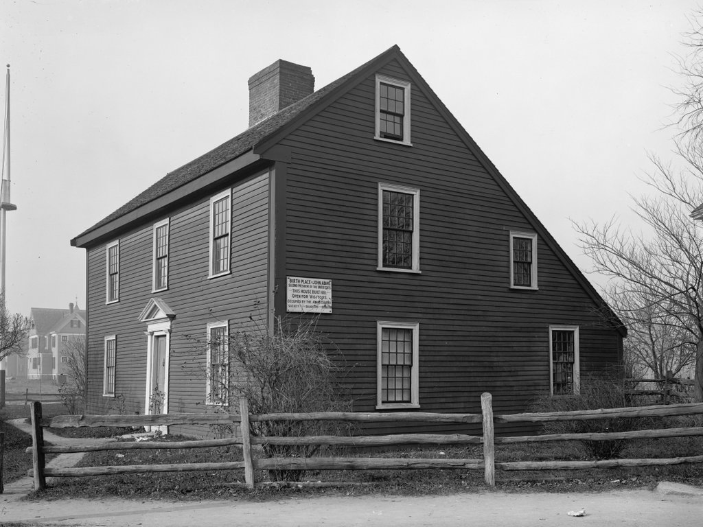
The John Adams birthplace at 133 Franklin Street in Quincy, around 1904. Image courtesy of the Library of Congress, Detroit Publishing Company Collection.

The house in 2019:

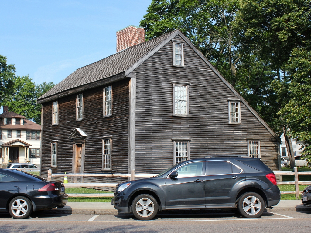
This house was built in 1722, although its structure incorporated timbers from an earlier 17th century house that may have stood on this same site. As such, it is one of the oldest surviving houses in Quincy, predating even the establishment of the town by 70 years. However, the house is best known as the birthplace and childhood home of President John Adams, who was born here on October 30, 1735.

The president’s father, Deacon John Adams, purchased this property in 1720, which consisted of seven acres of farmland in what was, at the time, part of the town of Braintree. He built the current house about two years later, although it would be another 12 years before he married his wife Susanna Boylston in 1734, when he was 43 and she was 26. Their son John Adams was born a year later, in the east bedroom on the second floor, at the corner of the house closest to the foreground in this scene. They went on to have two more sons, Peter and Elihu, and Deacon John lived here until his death in 1761 at the age of 70.

In the meantime, the future president and founding father spent his childhood here in this house, before leaving for Harvard in 1751 when he was 16. After graduation, Adams spent time in Worcester, where he studied law and worked as a teacher for a few years before returning to his hometown. After their father’s death, his brother Peter inherited this house, with John receiving the house next door, which his father had acquired in 1744. John apparently continued to live here in this house, though, until his marriage to Abigail Smith in 1764.

John and Abigail Adams then moved into the neighboring house, and three years later their son, John Quincy Adams, was born in that house in 1767. As a result, these two houses are the closest presidential birthplaces in the country, standing only 75 feet apart. John Adams eventually purchased his birthplace house from his brother in 1774, and rented it to other tenants. He and Abigail continued to live in the other house until 1788, although he spent much of this time away from home, including spending much of the American Revolution as a diplomat in Europe.

Upon returning from Europe in 1788, the Adamses moved to a much larger house elsewhere in town, which they named Peacefield. However, John continued to own both of these houses until 1803, when he sold them to John Quincy Adams. The properties would subsequently be owned by several more generations, and for much of the 19th century they were used as rental properties.

Both houses remained in the Adams family for many years, although by the turn of the 20th century they had become museums, with the Quincy Historical Society occupying the John Quincy Adams birthplace, and the Adams Chapter of the Daughters of the American Revolution here in the John Adams birthplace. The first photo was taken during this time, as indicated by the DAR sign on the side of the house.

The family finally sold both houses to the city of Quincy in 1940. In 1960, they were designated as National Historic Landmarks, and in 1978 they were transferred to the National Park Service. Along with the Peacefield mansion, the houses are now part of the Adams National Historical Park, and they are open to the public for guided tours.

Wilson Hotel, North Adams, Mass

The Wilson Hotel at the corner of Main and Holden Streets in North Adams, around 1901-1910. Image courtesy of the Library of Congress, Detroit Publishing Company Collection.

The scene in 2019:

The Wilson Hotel, also known as the Wilson House, opened here in 1866. At the time, North Adams was still part of the town of Adams, but this village was a growing manufacturing center. Between 1860 and 1870, the town as a whole grew from under 7,000 to over 12,000, and much of this increase was here in the northern section, which had a population of over 10,000 by 1880, several years after it was incorporated as the town of North Adams. During this time, the town’s prosperity was also aided by the ongoing construction of the Hoosac Tunnel nearby. Begin in 1851 and completed in 1875, the tunnel gave the town railroad connections to the east, and also put it on one of the major east-west routes through New England.

The hotel was owned by Allen B. Wilson, a former North Adams resident and inventor who made significant improvements to sewing machines. His company, the Wheeler & Wilson Manufacturing Company, was one of the leading American sewing machine producers of the second half of the 19th century, and Wilson used some of his profits to build a hotel here in his old hometown.

The building stood here at the northwest corner of Main and Holden Streets, in the midst of North Adams’s central business district. It stood four stories in height, with an ornate Italianate-style exterior comprised of brick and cast iron. In addition to about a hundred guest rooms in the hotel, it also included eight stores on the ground floor, plus a hall that could seat about 800 to 1,000 people. The hotel was intended to serve both travelers and long-term boarders, and it featured modern conveniences such as indoor plumbing, gas lighting, steam heat, and a telegraph office.

Around the mid-1870s, Foster E. Swift became the proprietor of the hotel. He and his wife Frances narrowly escaped death in the Ashtabula River railroad disaster of 1876, one of the deadliest train wrecks in American history, and he subsequently purchased the hotel in 1880. It appears to have been a foreclosure sale of some sort, because he acquired it from the Adams National Bank for just $65,000, barely half of the cost to build it 14 years earlier.

The 1880 census shows Foster and Frances Swift living here at the hotel. Most of the other staff apparently lived here too, with the census listing a clerk, a steward, two porters, two cooks, 12 waiters, and 11 other employees. About half were immigrants, with many coming from Ireland and a few from England and Germany. In addition, more than half of the staff members were female, most of whom were single and between 18 to 30 years old.

Also during the 1880 census, there were 40 residents living here as boarders. Some were families, but most were men in their 20s or 30s who lived here without any other family members. The majority of these were railroad employees, including nine conductors, two clerks, two agents, and a railroad contractor. Nearly all of these men were listed as being married, but they were evidently working and living away from home at the time when the census was taken.

Swift continued to operate the hotel for the next few decades, and during this time he was even elected to the state senate, representing the northern Berkshire district in 1883. He remained here until around the turn of the century, and the property was subsequently sold to John F. Sullivan, who was running the hotel when the first photo was taken around 1901 to 1910.

The first photo shows a busy scene in front of the hotel. Although around 40 years old by this point, it was still considered one of the finest hotels in western Massachusetts, and it housed a variety of other businesses on the ground floor. In the center, with the large awning, was the dry goods store of Tuttle & Bryant. To the right of it was a small postcard shop, and at the corner in the foreground was the Wilson House Drug Store, which advertised Coca Cola for 5 cents at its soda fountain.

However, the largest sign here on the front of the building was for the Empire Theater, a 1,400-seat theater that opened in 1901. It was located in the rear of the hotel, but the entrance was here on Main Street, just to the left of the drug store. The theater was ultimately in existence for just over a decade, but it hosted at least one distinguished visitor when Theodore Roosevelt made a brief campaign stop here on April 29, 1912, during his bid to capture the Republican nomination for president. He spoke for 15 minutes to an enthusiastic crowd of about 2,000 people. It was reportedly the largest audience for a political speech in the city’s history, and Roosevelt himself remarked that “It was a bully crowd, it was a fine gathering.”

This event proved to be something of a last hurrah for the old Wilson Hotel, though. Just over two months later, the entire building, along with the Empire Theater and several other adjacent buildings, was destroyed in a massive fire. The fire, which was suspected to have been the work of an arsonist, began around 2:30 a.m. on the morning of July 2, in either the kitchen or laundry of the hotel. There were about 30 guests in the hotel at the time, and all of them were able to escape safely, although most lost all of their belongings. In the end, the fire caused about a half million dollars in damage, equivalent to over $13 million today, and it completely gutted the old hotel, leaving only the burned-out brick shell still standing.

In the aftermath of the fire, the site here on Main Street was soon rebuilt, although on a much smaller scale. Instead of the grand four-story, 100-room hotel, its replacement was a far more modest two-story commercial block. This building has survived far longer than its predecessor, though, and it is still standing here, as shown in the present-day scene. It is one of a number of historic buildings that line the north side of Main Street in North Adams, and it is part of the Monument Square – Eagle Street Historic District on the National Register of Historic Places.

Main Street from Monument Square, North Adams, Mass

Looking west on Main Street from Monument Square in North Adams, around 1900. Image from Picturesque Berkshire County (1900).

The scene in 2019:

North Adams is one of the newest municipalities in Massachusetts, having been established in 1878, but this area was originally settled more than a century earlier, in the mid-1700s. It was incorporated as the town of Adams in 1778, and over the years it developed into two distinct villages, located about five miles apart along the Hoosac River. Both became important manufacturing centers, but the northern village, shown here in these photos, ultimately outgrew the southern one, and in 1878 it was partitioned off as the town of North Adams.

The first photo was taken around 1900, at the height of North Adams’s prosperity. Between 1880 and 1900 it more than doubled in population, growing from 10,000 to over 24,000 in just 20 years, and in 1895 it was incorporated as a city. This quarter-mile section of Main Street, between Eagle Street and the Hoosac River, became the city’s central business district, and many of the commercial buildings in the first photo were constructed during this time.

This scene would undergo further changes only a few years after the first photo was taken, most notably with the construction of the Dowlin Block and the New Kimbell Building, both of which were completed in 1902. Other buildings would be added over the next few decades, and today many of these buildings are still standing, as shown in the present-day scene.

Starting on the far right of the 2019 photo is the First Baptist Church, which was completed in 1880. At some point the tower on the corner of the building was removed, but otherwise the rest of the church survives with few exterior alterations. Past the church, on the other side of Eagle Street, the corner building in the first photo is either gone or heavily altered, and beyond it is the two-story Mohawk Theater, built in 1938.

From this perspective, the first of the major commercial buildings is the seven-story Dowlin Block, which features an ornate Renaissance Revival-style granite facade. To the left of it is the somewhat smaller Hoosac Savings Bank Building. This four-story block was built around 1884, and it appears in the first photo, where it was much more prominent before the construction of its taller neighbors. On the other side of the bank is the New Kimbell Building, which was built around the same time as the Dowlin Block in 1902. It has Renaissance Revival architecture that is similar to the Dowlin Block, and it stands six stories in height.

Barely visible further in the distance is the Gastlick Building, which was originally constructed in the late 19th century but altered in 1925. It stands next to the Second Blackinton Block, which is located at the corner of Holden Street. This four-story brick Romanesque-style building was completed in 1888, and it also appears in the first photo. Although not visible in either photo, this building is adjacent to the First Blackinton Block, a long Italianate-style commercial building that was built in 1873 and still stands today.

Perhaps the most significant building that no longer survives from the first photo is the Wilson Hotel, whose two towers are visible in the distant center of the scene. Built in 1866, this was the largest hotel in the city until the early 20th century, when it was destroyed by a fire on July 2, 1912. This site, at the northwest corner of Holden Street, is now occupied by the Empire Building, which was built later in 1912.

Overall, many of the buildings on the right side of the first photo are still standing today, alongside other historic building that were constructed within a few years afterwards. However, the left side, on the south side of Main Street, has completely changed. The old buildings here were all demolished by around the 1970s, and they were subsequently replaced by several different one-story commercial buildings and a seven-story hotel, which stands further in the distance at the corner of American Legion Drive.

First Baptist Church, North Adams, Mass

The First Baptist Church, at the corner of Church and Main Streets in North Adams, around 1900-1910. Image courtesy of the Library of Congress, Detroit Publishing Company Collection.

The scene in 2019:

The First Baptist Church was established in 1808, with its parishioners meeting here on this site in a former Congregational church that had been built in 1782. The old building was moved just to the north of here in 1829 and a new one was constructed here. This one was, in turn, replaced by a new one in 1848, which was renovated in 1871 with a new front facade and tower. At the time, present-day North Adams was still a part of the town of Adams, but in 1878 it was incorporated as a separate town, and the church became the First Baptist Church of North Adams.

However, only a year later, on May 5, 1879, the church was destroyed by a fire. The cause of the blaze was never determined, but it started in the organ and burned for at least a half hour before being detected. By the time it was extinguished, most of the building was destroyed, and contemporary newspaper accounts estimated the cost of the damage to be at least $45,000.

Despite the loss, the church was quickly rebuilt here on the same site. The new church may have even incorporated the 1871 front facade and towers, although if so they would have been heavily modified; the earlier church building featured Gothic-style pointed arches, while the rebuilt one has rounded Romanesque arches. The building was dedicated on September 7, 1880, with a series of services that were held throughout the day. In the morning, the Rev. George W. Samson of Harlem preached a sermon on “Strength and beauty are in His sanctuary.” He was followed in the afternoon by the Rev. John B. Brackett of Brookline, who spoke on justification by faith, and the evening service was marked by a sermon from the Rev. A. J. Gordon of Boston, who preached from Psalm 84.

The first photo was taken sometime around the turn of the 20th century, showing the main facade of the church. Directly in front of the church is Monument Square, which features a Civil War statue that was sculpted by North Adams native Charles Niles Pike and dedicated in 1878. Just beyond the church, hardly visible on the far right side of the photo, is the original 1782 meeting house, which was converted into residential and commercial use after being moved in 1829.

Today, very little has changed in more than a century since the first photo was taken. There have been a few small changes to the exterior of the church, including the removal of the small tower on the far left side and the alteration or replacement of the spire atop the tall tower. Otherwise, though, it looks largely the same as it did when it was completed in 1880, and it remains an active Baptist church. The soldiers’ monument is also still standing here in Monument Square, and even the old meeting house behind the church has survived, although it has been heavily altered aver the years. Both of these building, along with a number of others here in downtown North Adams, are now part of the Monument Square–Eagle Street Historic District, which was added to the National Register of Historic Places in 1972.

Randall and Second Streets, Adams, Mass (3)

Looking north on Second Street toward the corner of Randall Street in Adams, around 1900-1915. Image courtesy of the Library of Congress, Detroit Publishing Company Collection.

The scene in 2019:

These photos were taken from the same spot as the ones in the previous post, just facing further to the north. The original photos, including ones featured in blog posts here and here, may have actually been intended as a panorama, because they line up with just a bit of overlap; the duplex on the far left here is the same building on the far right in the previous post.

In any case, these historic photos were taken in the early 20th century, when Adams was a fast-growing factory town. Its population had doubled in the 20 years between 1880 and 1900, and this period saw the development of new residential neighborhood, including these streets on the hillside immediately to the east of the center of town. Some of the houses here had already been built by the time the first photo was taken, but there were sill many vacant lots, and the streets were simply narrow dirt paths.

As mentioned in the previous house, the 1900 census shows that the duplex on the left, at 40-42 Randall Street, was the home of two different families. On the left side was Fred Wilder, a teamster who lived here with his wife Ida, their daughter, and a boarder. The other side of the house was rented by Grace Welch, a 23-year-old woman who lived here with her three children.

Also during the 1900 census, the house in the center of the photo, at 44 Randall Street, was owned by Arthur Randall, whose family may have been the namesake of the street. He was 26 years old at the time, and he, like several of his neighbors, worked as a teamster. At the time, four generations of the family lived here, including Arthur and his wife Azilda, their infant son Everett, Arthur’s father Levi Randall, grandfather Gilbert Harrington, and niece Ella Randall. Levi, who was 58 years old in 1900, worked as a carpenter, and according to the 1904 county atlas he was the owner of the duplex at 40-42 Randall Street.

The other house visible in the first photo is at 14 Second Street, located beyond and to the right of the Randall house. In 1900 it was owned by 43-year-old Marcus Harrington, the uncle of Arthur Russell. He was a blacksmith, and he lived here with his wife Elizabeth and their three children: Walter, Velma, and Earl. According to the 1904 atlas, he also owned the neighboring house at 16 Second Street. However, this house does not appear on the census, so it may have been either unbuilt or vacant in 1900.

Today, more than a century after the first photo was taken, much has changed in this scene. The roads look very different, having been widened and paved, and the exteriors of the houses have also changed, including the removal of the shutters, installation of modern siding, and alterations to the front porches. Overall, though, the turn-of-the-century houses are still standing here, and this scene is still easily recognizable from the first photo.

Randall and Second Streets, Adams, Mass (2)

The view looking northwest from the corner of Randall and Second Streets in Adams, around 1900-1915. Image courtesy of the Library of Congress, Detroit Publishing Company Collection.

The scene in 2019:

These two photos were taken from the same spot as the ones in the previous two posts, which face to the southwest and west. This particular view looks toward the northwest, with the town of Adams in the foreground and the Greylock Range in the distance. The present-day photo does not line up perfectly with the first one, as the line of sight from the original spot is blocked by the house on the far left, but the two photos show the same overall scene, including the two houses on the right side of the first photo, which still stand here in the second photo.

The houses here in the foreground were, for the most part, built around the late 19th century. During this time, Adams was growing in population, becoming an important manufacturing center on the Hoosic River, and residential neighborhoods were steadily making their way up the hillside to the east of town. Many of the house lots were still undeveloped by the time the first photo was taken at the turn of the century, as indicated by the cornfield in the foreground, but most of these would soon have houses on them.

The two houses on the right side of the first photo were both built sometime around 1900, and they are both included in that year’s census. At the time, the one furthest to the right, at 40-42 Randall Street, was occupied by two families. The left side was the home of 34-year-old teamster Fred Wilder, his wife Ida, their daughter Bertha, and a boarder who also worked as a teamster. On the right side was 23-year-old Grace Welch, who lived here with her three children. They ranged in age from 10 months to 7 years, and according to the census she had been married for nine years. It also listed her as being a widow, although subsequent censuses show her as being married to Melvin Welch, so this part of her record was likely in error.

To the left of the duplex is a single-family home at 38 Randall Street. In 1900 it was owned by Ai Davis, a 47-year-old stonemason who lived here with his wife Nora and their five children, the oldest of whom was 23 and the youngest was 5. Their oldest, Hiram, was a teamster, and two other children were listed as attending school. Like her neighbor Grace, Nora had also apparently married very young, because she was 39 years old in 1900 and had already been married for 24 years.

Further in the distance, the most visible building in downtown Adams is the Berkshire Cotton Manufacturing Company. Founded in 1889, the company grew quickly over the next few decades, and by the time the first photo was taken in the early 20th century it consisted of a large factory complex with a number of buildings in the center of the scene. In 1904, the company had around 2,400 people, making it a significant employer in a town that, at the time, had around 12,000 residents.

In more than a century since the first photo was taken, many changes have occurred here in this scene. The cornfield in the foreground is gone, having been replaced by the house on the far left side at some point around the 1920s. In the distance, the slopes of Mount Greylock are now far more wooded than they had been in the first photo, and much of downtown Adams is also now obscured by trees. The houses at 38 and 40-42 Randall Street are still standing though, as are some of the buildings in the Berkshire Cotton Manufacturing Company complex.

During the 20th century, Berkshire Cotton Manufacturing went through a series of mergers in the 20th century, eventually merging with Hathaway Manufacturing in 1955 to become Berkshire Hathaway. It continued to produce textiles here into the second half of the 20th century, and came under the control of a young Warren Buffett in 1965. The factory ultimately closed, and many of the buildings have since been demolished, but the company itself still exists. No longer a small-town cotton mill, Berkshire Hathaway is now a major multi-national holding company headquartered in Omaha, although its name continues to serve as a reminder of its origins here along the Hoosic River in Adams.