Old Country Store, Longmeadow, Mass

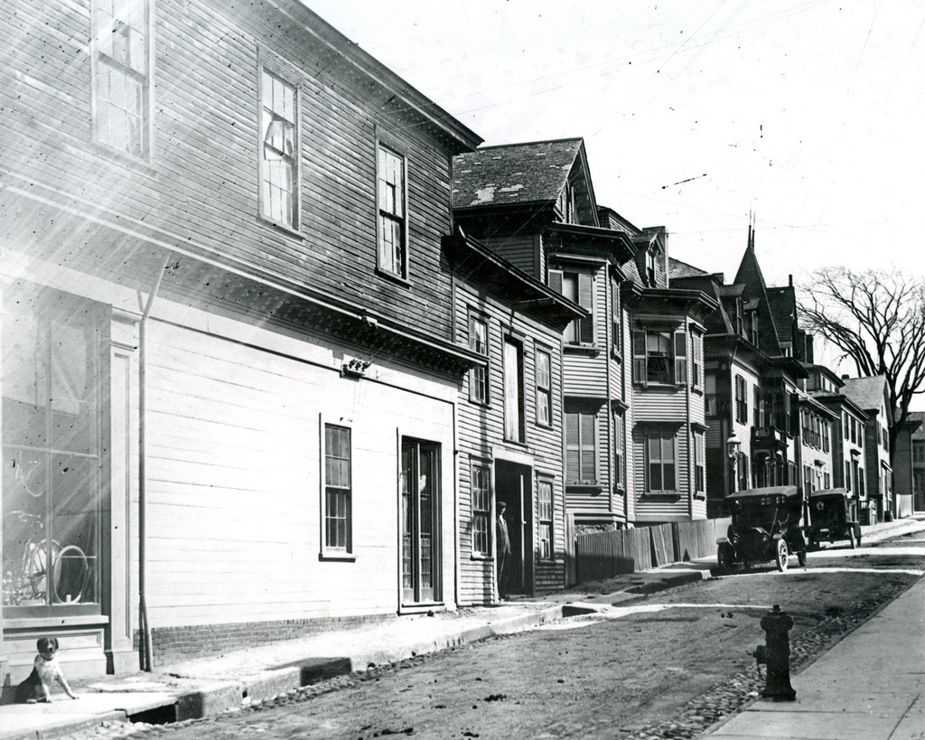
The Old Country Store at 776 Longmeadow Street, near the corner of Williams Street in Longmeadow, on October 14, 1912. Image courtesy of the Longmeadow Historical Society.
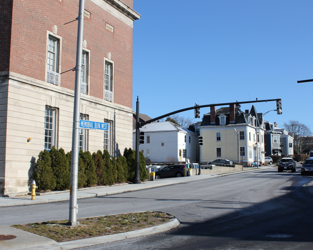
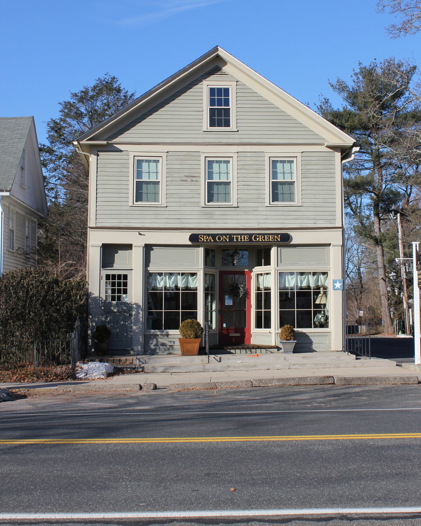
The scene in 2018:

This building was constructed around 1805, and was originally owned by Calvin Burt, who operated a general store out of the first floor. The post office was also located here for many years, and the building housed a variety of retail occupants throughout the 19th century. These included William White, who had a gold and silver thimble shop here from 1839 to 1848, in addition to his duties as a postmaster. He was succeeded by button manufacturer Dimond Chandler, whose factory was located here in a part of the building that has since been demolished. Chandler went into business with his son-in-law, Nelson C. Newell, an Nelson’s brother Samuel, and the two carried on the business after Chandler’s retirement in 1855. They would subsequently relocate to Springfield in 1864, opening a large factory on Howard Street.

The store was later used as a spectacle shop, but by the end of the 19th century it had again reverted to a general store, run by Charles Allen. He died in 1909, and by 1911 the store had been sold to Charles L. Wood, whose shop is visible in the first photo.The sign above the door advertises for “Meat and Groceries” and “Fish and Oysters,” and there is an assortment of fresh fruits and vegetables visible in the window on the left side. To the right of the door is a large display for “Pillsbury’s Best Flour,” which was “Made from selected hard wheat,” and “never disappoints.” On the left side of the building, just beyond the mailbox, is a bulletin board with a number of flyers, including one that reads “$20 reward,” although the rest of this flyer, including the details of the reward, is unreadable from this distance.

The business would be owned by several more merchants during the first half of the 20th century, and remained as a general store until 1964, when it became a women’s clothing store called The Separate Shop. The building now houses the Spa on the Green, but it has seen very few exterior changes since the first photo was taken more than 100 years ago. It survives as a rare, well-preserved early 19th century commercial building, and it is a contributing property in the Longmeadow Historic District, which was added to the National Register of Historic Places in 1982.

Thames Street from Cannon Street, Newport, Rhode Island

Looking east on Cannon Street from the corner of Thames Street in Newport, around 1915. Image courtesy of the Providence Public Library.

The scene in 2017:

The first photo shows the view looking up the hill along Cannon Street, a narrow side street that stretched one block from Thames Street to Spring Street. At the time, the street was lined with a variety of houses, most of which appear to have been built during the 19th century. On the left side, at the corner of Thames Street, was a bicycle shop, and several bicycles are visible in the window, just above the dog on the sidewalk. Aside from the bicycles, the cars in the distance are the only other sign of modernity, as the rest of this scene had probably not undergone any significant changes in several decades.

However, this scene would change dramatically within only a year or two after the first photo was taken. Around 1916, the buildings in the foreground were demolished to build a new post office, which now stands on the left side of the present-day photo. Further changes came in the mid-20th century, when Cannon Street was significantly widened to become Memorial Boulevard West. All of the buildings on the south side of the street were either demolished or relocated, but the few remaining ones here on the north side were largely unaffected, aside from being renumbered with Memorial Boulevard West addresses.

Today, the only surviving building that is easily recognizable from the first photo is the yellow Victorian-style house just to the right of the center in the 2017 photo. According to the Newport Historic District inventory, it was built around 1850. However, it must have been significantly altered later in the 19th century, because its Mansard roof and small turret are more in line with architectural styles of the 1870s and 1880s. The house is hard to see in the first photo, but it is partially visible just behind the first car. At the time, it was the home of Mary Maloney, an Irish immigrant who worked as a laundress and lived here with her sister, her niece, and her nephew. The house has since been converted into a bed and breakfast, and it is now the Burbank Rose Inn.

Perry Mill, Newport, Rhode Island (2)

The Perry Mill, looking north along Thames Street from the corner of Fair Street in Newport, around 1902. Image courtesy of the Providence Public Library.

The scene in 2017:

As discussed in the previous post, the Perry Mill was built in 1835, on Thames Street in the southern part of downtown Newport. It was originally a textile mill, and was one of several such mills built during this period, in an effort to revive the city’s struggling economy. Newport’s shipping business had fallen on hard times since the American Revolution, and the Perry Mill was an attempt to compete with New England’s rapidly-growing industrial cities. However, Newport’s location on an island in the middle of Narragansett Bay proved a barrier to railroad transportation, and its fledgling manufacturing base never achieved the prominence of nearby mainland cities such as Providence and Fall River.

Despite this, Newport’s economy did ultimately recover, largely through becoming a Gilded Age summer resort community. By the time the first photo was taken at the turn of the 20th century, some of the wealthiest families in the country had summer homes here in Newport, although most of these were to the south of the downtown area. This section of Thames Street remained decidedly working-class, as shown by the businesses here, which included a coal dealer on the left, a flour and grain dealer on the ground floor of the Perry Mill, and a grocer in the building just beyond the mill.

Today, much of this scene has changed, particularly the buildings just beyond the Perry Mill, which were demolished in the mid-20th century to build America’s Cup Avenue. The mill building itself also underwent some changes, with the removal of the gabled roof and fourth floor. For many years, the property was owned by General Electric, but it was subsequently converted into retail use, and the upper part of the building was reconstructed. The brick section on the left side is also a 20th century addition, but otherwise the only noticeable sign of change is the slightly different shade of stone between the three lower floors and the fourth floor.

Perry Mill, Newport, Rhode Island

The Perry Mill, seen from the corner of Thames and Cannon Streets in Newport, around 1914-1916. Image courtesy of the Providence Public Library.

The scene in 2017:

The first photo was taken sometime in the mid-1910s, during the construction of the present-day Newport Post Office. It shows a group of commercial buildings, most of which were probably built around the mid-19th century, and the signs advertise for a variety of businesses, including B. Richards Gents Furnishings in the building to the left, and a fish market and Lee Yun Laundry in the buildings to the right. There also appears to be a barber shop in the storefront just to the left of the fish market, as indicated by the striped poles on the exterior.

However, the most prominent building in the first photo is the Perry Mill, which stands diagonally across the intersection in the center of both photos. It was built in 1835 as a textile mill, at a time when Newport had been experiencing several decades of economic stagnation. The city’s once-prosperous shipping industry had been badly hurt by the American Revolution, and never fully recovered. By the early 19th century, much of New England’s economy had shifted from trade to industry, and inland manufacturing centers had begun to eclipse colonial-era seaports such as Portsmouth, Salem, and Newport.

Architecturally, the Perry Mill was very different from most other New England mills of this period. Instead of a brick exterior, it was built of stone, and featured details such as lintels over the windows, quoins on the corners, and a fanlight just underneath the gable. It was the work of Scottish-born stonemason Alexander MacGregor, and was one of the few major building projects in Newport during this period. However, despite hopes that the mill would revive the city’s economy, Newport never became a major industrial center. Its location on an island, which had benefitted its merchant fleets, proved a liability in the age of railroads, and Newport would not see widespread prosperity until the second half of the 19th century, when the city reinvented itself into one of the country’s most exclusive summer resort communities.

The mill was still standing in its original appearance when the first photo was taken, but at some point in the 20th century it was heavily altered with the removal of the gabled roof and fourth floor. From 1943 to 1984, the building was owned by General Electric, but it was subsequently converted into retail space, and now houses shops and restaurants. As part of this renovation, the upper part of the building was reconstructed, and the only noticeable evidence of this change is the slightly lighter-colored stone above the third floor.

Today, the Perry Mill stands alone in this scene, with none of the other buildings surviving from the first photo. The post office, which was barely under construction when the first photo was taken, is still there, but the rest of the area has dramatically changed. In the mid-20th century, the four-lane America’s Cup Avenue was built along the waterfront of Newport, running along the west side of Thames Street for part of its route. This meant that many Thames Street buildings had to be demolished, including the ones on the right side of the first photo. However, just before reaching the Perry Mill, America’s Cup Avenue makes a sharp left turn, becoming Memorial Boulevard West. This was constructed around the same time, and involved demolishing all of the buildings on the south side of Cannon Street, including the one on the left side of the photo. As a result, the Perry Mill was spared by these projects, and it remains a prominent landmark along Newport’s waterfront.

Spring and Mill Streets, Newport, Rhode Island

The northwest corner of Spring and Mill Streets in Newport, around 1928. Image courtesy of the Providence Public Library.

The scene in 2017:

The first photo shows an evidently abandoned building that once stood at the corner of Mill and Spring Streets in Newport. It was probably built at some point in the second half of the 18th century, as it shares many common architectural features of this period, most notably the gambrel roof. Many surviving Newport buildings have a similar style, including the somewhat smaller White Horse Tavern building, which was originally constructed in the 17th century but was expanded to its present-day appearance a century later.

The 1777 map of Newport shows a building standing here at the corner, although it is unclear whether it was this particular building or an earlier one. Either way, the building was here by the 19th century, and the 1876 city atlas shows that the property belonged to Theodore R. Helme. His occupation was variously listed as a mason, carpenter, auctioneer, and grocer, and he also owned the commercial block that still stands on the opposite side of the street, at 148-160 Spring Street. He died around the turn of the 20th century, but the 1907 city atlas shows that his widow Ruby still owned this property, along with the one across the street.

The first photo shows that the building had several storefronts on the ground floor, and the upper floors were presumably divided into apartments. However, by the time the photo was taken in 1928, the building had fallen into serious disrepair. The upper floors were clearly empty, with hardly any surviving windows, and the storefronts also appear to have been vacant. The sign above the stores is completely illegible, and the only things visible in the windows are posters advertising for a circus on Wednesday, May 31. If the 1928 date of the photo is accurate, these posters must have been there for a long time, because the last time May 31 had fallen on a Wednesday was in 1922, and it would not do so again until 1933.

Based on its condition in the first photo, this building likely did not survive beyond the 1930s at the latest. The neighboring building on the far right side has also since been demolished, and today the area is a park adjacent to Trinity Church. Only the top of the church spire is visible in the first photo, but the entire building can now be seen from this angle. It was completed in 1726 and it features a design that is very similar to that of Old North Church in Boston, which was built only a few years earlier. Although the other buildings from the photo are gone, the nearly 300-year-old church is still standing, and in 1968 it was designated as a National Historic Landmark because of its architectural and historical significance.

Broadway from Farewell Street, Newport, Rhode Island

Looking north on Broadway from the corner of Farewell Street in Newport, around 1884. Image courtesy of the Providence Public Library.

The scene in 2017:

This view shows the west side of Broadway, looking north from the Colony House at the corner of Farewell Street and Courthouse Way. Although taken more than 130 years apart, not much has changed in these two photos. Like much of downtown Newport, this area has remained remarkably well-preserved since the colonial era, and both photos show an eclectic mix of historic buildings that date as far back as the 17th century.

Perhaps the oldest building in this scene is the one on the far left, at 2-6 Broadway. It was built sometime before 1700, and was once owned by Peleg Sanford (1639-1701), who served as the colonial governor of Rhode Island from 1680 to 1683. Sanford came from a leading Rhode Island family, with his father, John Sanford (c.1605-1653), having briefly served as governor of Newport and Portsmouth in 1653. However, his most notable relative was his grandmother, Anne Hutchinson (1591-1643), the famed religious dissenter whose 1638 banishment from Boston had helped lead to the establishment of Newport.

Peleg Sanford died in 1701, and the house was later owned by his son-in-law, Job Almy, who purchased the property in 1723. The house would remain in the Almy family for over a century, until it was sold in 1827. By this point, the first floor of the house had been converted into a storefront, and the building would see even more drastic changes around 1845, when it was enlarged to its present size. This addition concealed most of its original appearance, although the building retained its overhanging second floor, which was a distinctive feature of many 17th century homes.

By the time time the first photo was taken around 1884, the building was occupied by several commercial tenants, including J. B. Deblois & Son, whose grocery store was located in the corner storefront. In later years, the ground floor was occupied by Lalli’s, a variety store that was in business here from 1923 until 1986. It was during this time that, in 1976, the exterior of the building was restored, giving it more of a 17th century appearance. Today, despite all of these changes, the structure of the original house is still there, making it possibly one of the oldest surviving buildings in Newport.

Aside from the Peleg Sanford House, there are a number of other historic buildings in this scene. Immediately to the right of it is the William P. Shefield House, which was built around 1850, although its exterior has been altered beyond recognition since the first photo was taken. Next, in the center of the scene, is the William H. Stanhope House, at 12-18 Broadway. It was built around 1815 as a private home, and its Federal-style architecture is still recognizable today, despite having been converted to commercial use during the 19th century. Further in the distance, barely visible in the 2017 photo, are two late 18th century homes at 20-24 and 26-30 1/2 Broadway, both of which are also now commercial properties.

Today, the vehicles on the street have changed, and this block of Broadway is now a one way street for southbound traffic, but otherwise the buildings themselves have seen few changes. All of them are now contributing properties in the Newport Historic District, which encompasses much of downtown Newport. The district was designated as a National Historic Landmark in 1968, because of the survival of so many historic buildings from the 17th, 18th, and 19th centuries.