Thomas Wason House, Springfield, Mass

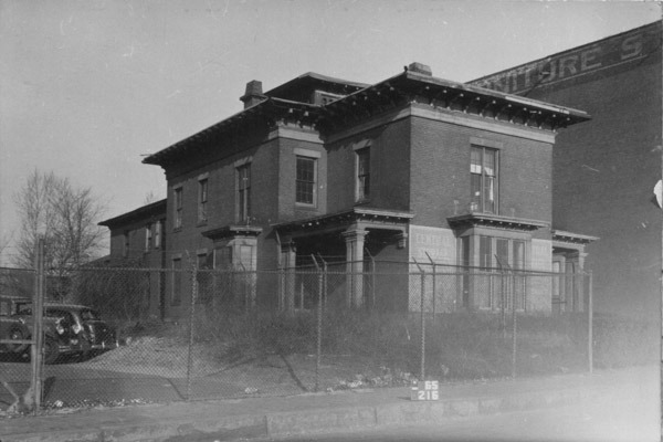
The house at 270 Liberty Street in Springfield, around 1938-1939. Image courtesy of the Springfield Preservation Trust.
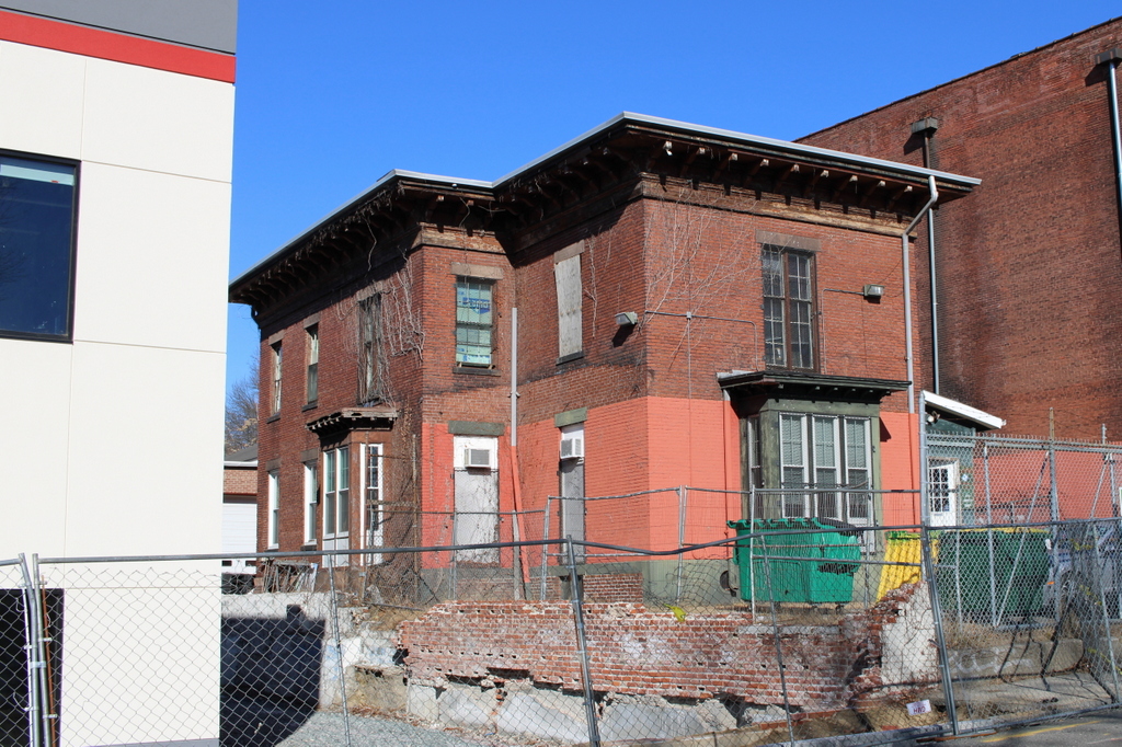
The house in 2019:

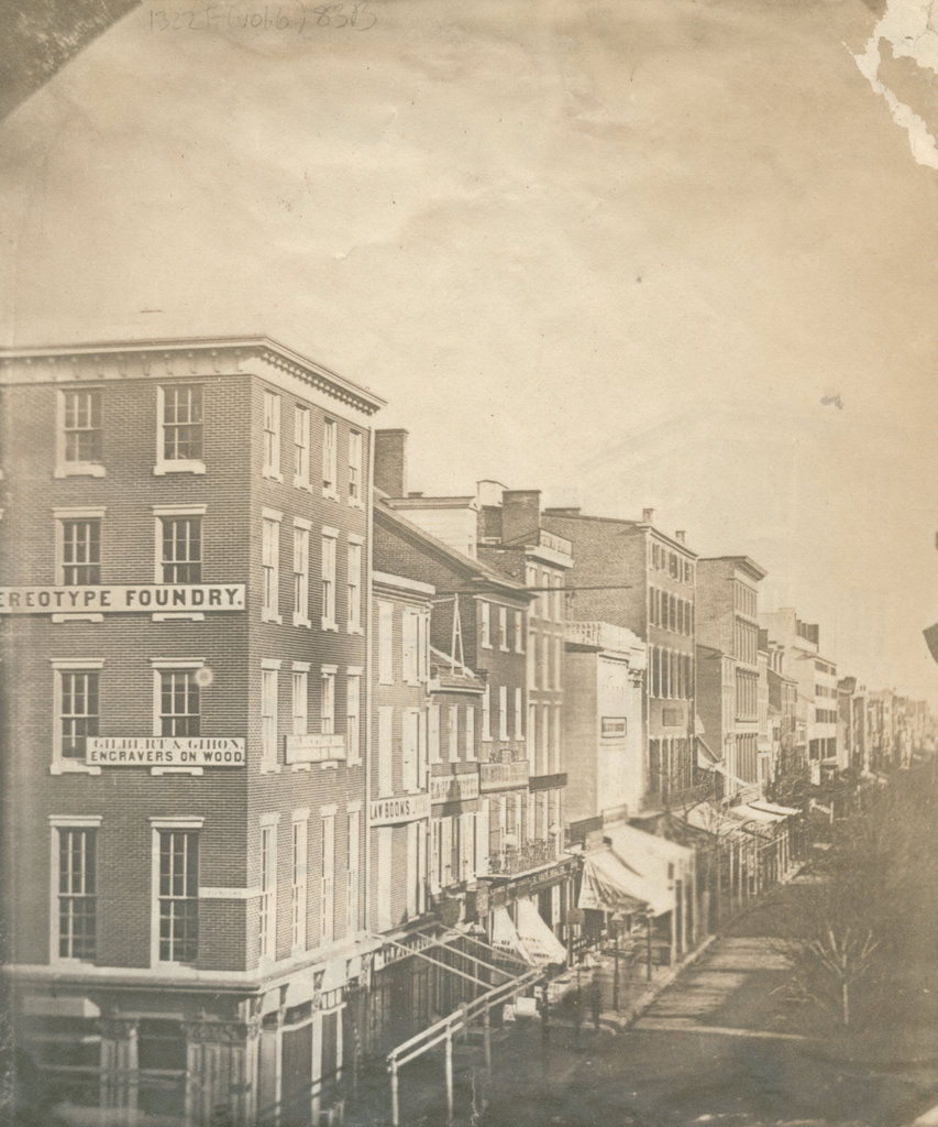
This brick Italianate-style house was built sometime around the early 1850s, and it was the home of Thomas Wason, the founder of the Wason Manufacturing Company. At the time, this area of Springfield to the east of Chestnut Street and north of the railroad tracks was sparsely developed, consisting primarily of upscale homes that were modeled on rural Italian villas. A number of these houses are visible in the first photo of an earlier post, which shows the view around 1882, before the area was transformed into the working-class Liberty Heights neighborhood at the turn of the 20th century.

Thomas Wason was born in New Hampshire in 1811, and he grew up in a family with 15 children. His father was a carpenter, so Thomas worked in the shop when he was young, and gained valuable skills that he would put to use after he and his younger brother Charles moved to Springfield in the 1830s. At the time, Springfield was a small but rapidly-growing manufacturing center, and it was also an important transportation hub that would soon become the crossroads of several important railroads.

The Wason brothers took advantage of this new method of transportation, and they started out by preparing timbers for railroad bridges and repairing railroad cars before starting a railroad car manufacturing business in 1845. The company started small, with the Wasons producing cars in a shed that was not even large enough for a single car. However, the rapid growth of the nation’s railroad system resulted in high demand for railroad cars, so the Wasons soon moved to a larger facility. Then, in 1848, they moved again, to the factory of the former Springfield Car and Engine Company, which was located in the block between Lyman and Taylor Streets in downtown Springfield.

Charles Wason ultimately left Springfield in 1851 and moved to Cleveland, where he established his own railroad car company. Thomas purchased his brother’s interest in their partnership here in Springfield, and he carried on the business for many years, turning it into one of the nation’s leading railroad car manufacturers. During that time, the Wason Manufacturing Company produced cars for most major railroads, and also had several overseas contracts, including a 161-car order that was sent to Egypt in 1860. The company also produced the nation’s first sleeping car in 1857, predating the more famous Pullman sleeping cars by several years.

The Wason company was one of the most important industries in Springfield during the second half of the 19th century, and the 1884 book King’s Handbook of Springfield declared that “no manufactory in Springfield has been more world-famed; and none has, during the past twenty years, handled so much money.” Thomas Wason himself also handled plenty of money, and by the mid-1860s he ranked among the city’s top earners, with an 1864 income of $17,944, equivalent to over $300,000 today.

Thomas Wason was around 40 years old when moved into this house in the early 1850s. He and his wife Sarah had two children, Jane and George, who would have been adolescents at the time. Like most affluent families of the period, they also employed servants who lived here in the house; the 1860 census lists 19-year-old servant Edwin Mehan, who was an Irish immigrant. A decade later, the family employed 18-year-old Annie Harris and 16-year-old Ellen Davis. Both were originally from Virginia, and Harris was listed as mulatto and Davis as black, so it is possible that the two may have previously been enslaved in Virginia.

In addition to manufacturing railroad cars, Thomas Wason’s business interests included being involved with several local banks. He was vice president of the Hampden Savings Bank, and he was also one of the directors of the First National Bank of Springfield. Wason was also active in local politics, serving at various times on the city council, the board of aldermen, and in the state legislature.

Thomas Wason died in 1870 at the age of 58, and he left behind an estate that was valued at nearly $450,000, or more than $9 million today. By far his largest asset was his ownership interest in Wason Manufacturing, which amounted to 760 shares worth a total of $200,000. He also held more than $60,000 in shares of companies like the Springfield Fire and Marine Insurance Company, the First National Bank, the Boston and Albany Railroad, and the Michigan Central Railroad. Most of his remaining personal estate was in the form of bonds and promissory notes, which were valued at more than $112,000. Wason also owned $58,500 in real estate, including his house here on Liberty Street, which was assessed at $20,000.

Sarah Wason continued to live here in this house for at least five years after her husband’s death, but she had evidently moved out by 1876. The 1880 census shows her living next door at 284 Liberty Street, at the home of her daughter Jane and son-in-law Henry S. Hyde. However, her old house here at 270 Liberty Street would remain in the family for many years, although it appears to have been used primarily as a rental property. Starting around 1877, it was the home of Aaron Wight, a sawyer who sold wood to railroads. He was also the brother of Emerson Wight, the mayor of Springfield from 1875 to 1878. Aaron lived here in this house for the rest of his life, until his death in 1885 from typhoid malaria at the age of 63.

By the late 19th century, this part of Springfield had begun to change. As the city grew, the old estates here were steadily subdivided into new residential streets, and the neighborhood became predominantly working class, with a number of immigrants and second-generation Americans. The area also became more industrialized during this period, thanks to its proximity to the railroad tracks. The 1899 city atlas shows a rail yard directly across the street from the house, and nearby industries included a stone yard, a coal yard, and a boiler and iron works.

The house was still used as a residence in 1900, although it was apparently divided into multiple units. One of the residents in that year’s census was George K. Geiger, superintendent at the Springfield Steam Power Company. He was an immigrant from Germany, and he lived here with his wife Rosa and their two sons, George and Arthur. The other family living here at the time was Hector and Nell Davis, who lived here with their children Mabel, Fred, and Eugene. Hector was a conductor for the Boston and Maine Railroad, and Mabel and Fred both worked as clerks.

This property underwent a dramatic transformation around 1909, when the Central Storage Warehouse purchased it and built a brick warehouse behind and to the right of the old house. The building evidently functioned much in the same way as modern storage units, with the company advertising, “Storage rooms to let. For furniture and other goods in separate locked compartments.” The warehouse was subsequently expanded in the early 1910s, with a new wing that extended all the way to Liberty Street, as shown on the right side of both photos here.

George Geiger was involved with the company in its early years, working as mechanical engineer and superintendent. By the 1910 census, both he and the Davis family were still living here in the house, although the Davises moved out soon after, and the Geigers left in 1912, when George resigned from his position with the company. After the Geigers, the last long-term resident of this house appears to have been Linda Daniels, who was here from around 1912 until her death in 1921. During the 1920 census she was 60 years old, widowed, and lived in the house with three of her children.

By the mid-1920s, the property seems to have been exclusively commercial in use. During this period, the company frequently listed advertisements in local newspapers, which reflected an expansion of its services beyond just storage. One 1925 ad offered “Local and long distance moving, packing, crating, storage of household furniture, pianos, office effects, merchandise.” Another ad from the same year assured potential customers, “Don’t worry on moving day. Call R. 98 and your moving problems will be solved to your complete satisfaction; storage for household, personal and office effects in strictly fireproof building; skilled workmen, competent to pack and crate any article safely.” In addition to these ads, the company also frequently posted classified ads for auctions and other sales of furniture, antiques, and similar items.

Judging by the few advertisements that appeared in the newspaper for Central Storage Warehouse in the 1930s, the business was probably hurt by the Great Depression. The first photo was taken during this time, probably around 1938 or 1939, and the company’s only appearance in the newspapers in those years seems to have been a December 1939 classified ad listing female canaries for sale, which were “guaranteed singers.”

The company remained here as late as 1940, but its business license was revoked in the fall of that year, and in February 1941 the property was sold at a foreclosure sale to the moving and storage company Lindell & Benson. Within a few years Lindell & Benson became Anderson & Benson, and this moving company would go on to operate here for many years before it was acquired by Sitterly Movers in 1975.

Today, the house has come a long way since being the home of one of Springfield’s most prosperous 19th century industrialists, and it has seen some exterior changes since the first photo was taken, including the loss of the porches on the left and right sides of the house. It is now almost entirely surrounded by larger industrial and commercial buildings, and the vacant lot on the left side of the first photo is now a building that partially blocks the view of the house from this angle.

Otherwise, though, remarkably little has changed in this scene over the past 80 years. Despite the exterior alterations, the house is still standing as one of the few survivors of the once-numerous Italian villas in this area. The early 20th century warehouse next to it is also still standing, with the same “Furniture Storage” advertisement still visible at the top, although it is more faded than in the 1930s. This property is still owned by Sitterly Movers, which continues to use this location as its Springfield branch, and in 2016 both buildings were designated as a local historic district.

Highland Ice Company, Springfield, Mass

The Highland Ice Company on Coleman Street in Springfield, around the turn of the 20th century. Photo from author’s collection.

The scene on October 4, 1938. Image courtesy of the Springfield Building Department.

The scene in 2019:

The first photo here is from my family’s old photos, and it shows the ice business of my great-great uncle, George M. Lyman. It is actually a composite image; it appears to have been two separate images that were developed on the same sheet of photo paper, with a gap in the middle. I digitally eliminated the gap, and stitched the two images together to form a single panoramic view of the scene. The photo is undated, but the writing on the back, which reads “For Uncle Arthur from Leslie,” suggests that it was probably taken sometime between 1908 and 1912. The Leslie who wrote it is probably Leslie Page, who married George Lyman’s stepdaughter in 1908, and Uncle Arthur appears to have been Arthur W. Lyman, George’s older brother. Arthur worked as a teamster for the ice business, but he died in 1912, so the photo must have been taken before then.

The people in the photo are unidentified; it is possible that the man carrying the block of ice in the foreground might have been either Arthur or George, but I have never seen photos of either of them before. In any case, though, the photo was definitely taken on Coleman Street, right next to George Lyman’s house at 34 Coleman Street. The house is directly behind the photographer and not visible in the scene, but the photo shows several outbuildings on the property that were used by the ice business, including a large shed in the center, an ice bin on the right, and part of another shed on the far left. The photo is facing north, and the house in the distance on the left is at 153 Boston Road, which stood directly opposite Jasper Street.

George Lyman was originally from Wilbraham, and he grew up on the family farm on Springfield Street, just east of the Springfield boundary. His family was relatively prosperous, and he attended the town’s private high school, Wesleyan Academy, which is now Wilbraham-Monson Academy. Most of his siblings also attended the school, as did both of his parents, and both of his grandfathers had been trustees of the school. George’s father died when he was 13, and he subsequently assisted his mother on the farm. However, in the early 1890s, when he was 22, he moved to Springfield and entered the ice business.

At the time, in the days before electric refrigeration, ice was a valuable commodity. Aside from providing cold drinks on hot summer days, it also played an important role in the nation’s food supply by preserving meats and other perishable foods. This allowed food to be stored longer and transported further, and ice was used in large-scale commercial settings and in the iceboxes of individual households.

The commercial ice industry peaked in the 19th and early 20th centuries, and it was particularly prevalent in the northeast, which had the ideal combination of cold winters and extensive transportation networks to move the ice. The ice was harvested in the winter from lakes, ponds, and occasionally rivers, typically once the ice was about 18 inches thick. It was cut into blocks, and then stored in ice houses, where it could be kept until the following winter. From there, the ice could be used locally during the warm months, or it could be sold to different parts of the country or even overseas.

After moving to Springfield in the early 1890s, George Lyman lived in several different places before moving to 34 Coleman Street around 1899. At the time, Springfield’s Pine Point neighborhood was just beginning to be developed into a residential suburb, and Lyman would have been among its early residents. He was about 30 years old, and he had recently married his wife Laura, a widow six years his senior who had three children from her previous marriage. George and Laura would subsequently have a child of their own together, Ralph, who was born in 1900, but he died at the age of seven.

The 1899 city atlas shows the Lyman home on one parcel, and the outbuildings on the next two parcels to the north. The ice bin on the right side of the first photo was not built yet, but the other two sheds were. Unlike the house, which was listed as belonging to George, these two parcels were owned under Laura’s name. George conducted his ice business here, and the large shed in this photo was apparently used to store the wagons, which were used to deliver the ice to both retail and commercial customers. As indicated by the wagon on the left, it was known as the Highland Ice Company, and the ice was harvested from Loon Pond, about two miles to the east of here on Boston Road. George owned a parcel of land at the southwest corner of the pond, at the corner of Boston and Pasco Roads, and this is apparently where his ice house was located.

The ice business was labor-intensive work, starting with the cutters who worked on frozen ponds in the middle of winter and ending with the teamsters who delivered it to homes and businesses throughout the year. George Lyman occasionally published classified ads looking for workers, including one in 1906 that sought an “ice peddler” and promised “good wages for the right man.” Nearly a decade later, in 1915, he posted another ad looking for two peddlers, and the only requirement listed was that they “must be temperate.” In addition, several of George’s family members worked for him, including the above-mentioned brother Arthur. According to family tradition, his younger brother Frank Lyman—my great grandfather—also worked for him, although this may have been on a temporary basis, because census records and city directories all indicate that Frank’s primary occupation was as a machinist.

During the early 20th century, George Lyman appears to have harvested about 3,000 to 4,000 tons of ice per year, although the particularly cold winter of 1911-1912 was a boon for ice dealers, and by the end of February he had stockpiled about 6,000 tons. That year, an article in the Springfield Republican listed the amount harvested by different local ice companies, and he was tied for the fifth-highest out of the nine dealers on the list. Based on contemporary advertisements in the newspapers, he generally sold his ice for 40 cents per 100 pounds to retail customers, 30 cents to drugstores, and 25 cents to markets.

George Lyman was apparently looking to get out of the ice industry as early as 1913, when he published a classified ad that read, “Having been in business 21 years, would like to sell 3000 tons of ice, house, barn, sheds, wagons, horses, tools, elevator, icehouse, etc.” However, he must not have had any takers, since he continued to run the business for several more years before selling it to the Harder Grain and Coal Company around 1915. He then turned his attention to the family farm in Wilbraham, but he continued to live here on Coleman Street until around 1925, when he and his wife Laura moved to Wilbraham.

The first photo was taken in 1938 as part of a WPA project to document every building in the city of Springfield. By this point the ice bin on the right side had been removed, but the old shed was still standing, although its condition had deteriorated considerably since the days when George Lyman ran his ice business here. The old horse-drawn ice wagons were long gone by then, and the dump truck in one of the bays demonstrates the ways in which transportation had changed over the past few decades.

During this time, the surrounding neighborhood had also changed. By the late 1930s, Pine Point had become much more developed, and Boston Road was now lined with a number of businesses. The house in the distance on the left side of the first photo was gone by this point, and it was replaced by a row of commercial buildings, one of which is partially visible on the far left side of the second photo. Among the retail tenants of these buildings was the first Friendly’s restaurant, which had opened in 1935 in a storefront directly behind the old shed. There, brothers S. Prestley and Curtis Blake got their start in selling ice cream, just yards away from where George Lyman had once sold ice.

Today, more than 80 years after the second photo was taken and over a century after the first one, the old shed is long gone. Lyman’s house at 34 Coleman Street is still standing, but the other two parcels next to the house have been transformed. Around 1954 a house was built on the lot directly adjacent to his old house, and it stands approximately on the spot where the first photo was taken. The other lot, where the shed was once located, is now part of a parking area for the businesses on Boston Road. These early 20th century commercial buildings are still standing today, and they are visible on the left side of the present-day photo. Furthest to the right in the photo, directly behind the telephone pole, is the part of the building that was once occupied by the first Friendly’s restaurant.

North Pearl Street from State Street, Albany, New York

Looking north on North Pearl Street from the corner of State Street in Albany, around 1904. Image courtesy of the Library of Congress, Detroit Publishing Company Collection.

The scene in 2019:

Pearl Street is one of the main north-south streets through downtown Albany, and these photos show the view looking north from the corner of State Street. When the first photo was taken, much of the streetscape consisted of four-story brick Italianate-style commercial buildings from the second half of the 19th century. However, the one major exception was the Albany Savings Bank, which stands on the left side of the scene. The building, with its Corinthian columns and large dome, was designed by noted architect Henry Ives Cobb, and it was constructed in 1898.

Just to the left of the bank was another notable downtown building, the Tweddle Building. It stood at the corner of State and North Pearl Streets, and it is more visible in a photo from an earlier post, which shows it from State Street. Here on the North Pearl Street side of the building, it had several different retail tenants on the ground floor. Starting on the far left side of the first photo, it housed “Cut Price Druggists,” which had a window advertisement for “Lime-Ade,” declaring it to be “First Aid to the thirsty.” Just to the right of the drugstore is the Whittle Brothers florist shop, and further to the right is the umbrella shop of J. McElwee, which had an outdoor display advertising for “Covering and Repairing” of umbrellas.

Elsewhere in the first photo, a number of signs adorn the sides of the buildings and extend outward across the sidewalk, hoping to catch the attention of the pedestrians. On the far right side near the foreground, these included the Albany & Troy Candy Kitchen, the Hallwood Cash Register Company, Harry Ellis’s men’s furnishings shop, the W. F. Antemann & Son jewelry shop, and the Joseph Feary & Son boot and shoe store. Antemann’s shop was marked by a large pocket watch sign, but many of his competitors apparently had the same idea, since there are at least three similar pocket watch signs visible across the street on the left side. Also on the left side, just beyond the bank, is Failing’s Apothecary, with a name that inspires even less confidence than the competing “Cut Price Druggists” a block away.

On the street, the traffic in the photo consists primarily of horse-drawn wagons. The most visible of these is the well-decorated wagon of the Grand Union Tea Company, on the far left side of the photo. The driver is perhaps delivering tea to the Cut Price drugstore, and the horse is staring directly at the camera. There are no automobiles visible in the photo, although by this point there were already thousands registered in the state of New York, and within just a few years they would largely displace the horse-drawn vehicles. In the meantime, though, the only sign of new transportation methods in the first photo is the electric trolley in the distance.

Today, around 115 years after the first photo was taken, very little remains of the early 20th century scene, especially here in the foreground. Cars now dominate the street, with not a draft animal in sight, and even the trolleys are long gone, having been replaced by buses, such as the one in the lower center of the 2019 photo. Most of the buildings here are also gone. Among the first to be demolished was the Tweddle Building on the far left, which was replaced by the 17-story Ten Eyck Hotel in the mid-1910s. This hotel was then demolished in the early 1970s, around the same time as the Albany Savings Bank building. The spot where the hotel once stood is now a modern office building, and the site of the bank is the Ten Eyck Plaza.

Despite all of the changes, though, there are a few surviving buildings near the foreground on the right side of the scene. Closest to the camera is the four-story building at 23-25 North Pearl Street, which was occupied by Feary’s boot and shoe store in the first photo. It was built in 1854, and it is still standing today, with few significant exterior changes aside from the storefronts. A little further north, just beyond Maiden Lane, are two other historic buildings, at 29-31 North Pearl Street. These were built in 1869 and feature distinctive cast iron lintels over the windows. The main facade of 29 North Pearl was altered at some point in the 20th century with a Tudor-style appearance, but otherwise the buildings are still recognizable from the first photo.

Overall, the best-preserved section of this scene is far in the distance. The two blocks between Pine and Columbia Streets are still lined on both sides with predominantly 19th and early 20th century buildings. These include the former YMCA building, site of the first basketball game played away from the sport’s Springfield birthplace, and the Kenmore Hotel, an ornate High Victorian Gothic building that opened in 1878. These buildings, along with the other historic buildings in this scene, are now part of the Downtown Albany Historic District, which was added to the National Register of Historic Places in 1980.

State Street from Broadway, Albany, New York

Looking west on State Street from near the corner of State Street and Broadway in Albany, around 1902-1910. Image courtesy of the Library of Congress, Detroit Publishing Company Collection.

The scene in 2019:

This scene is very similar to the one in the previous post, except these photos were taken a couple blocks further to the east, at the corner of State Street and Broadway. From here State Street, is visible for a quarter mile in the distance as it rises up the hill toward the New York State Capitol. This stretch of road is at the center of downtown Albany, and it has been the site of many historic buildings over the years.

When the first photo was taken, the buildings on the right side of this scene consisted of a mix of late 19th century commercial buildings, most of which were between four and six stories in height. The one outlier here was the nine-story Ten Eyck Hotel, which was built in 1899 and stands in the distance near the center of the first photo.

The buildings in the first photo were occupied by a mix of different businesses. Starting in the foreground, these included the Albany Hardware and Iron Company in the two buildings on the far right, and the Union Trust Company in the ornate light-colored building to the left of it. Further up State Street, the ground floor of the six-story building was occupied by the Cluett & Sons piano store on the right and the William M. Stetson stationery store on the left. Beyond that building, the next two housed a Western Union telegraph office and the Commerce Insurance Company.

Today, more than a century after the photo was taken, hardly any of these buildings are still standing on this side of State Street. The former site of Albany Hardware is now a 12-story office building at 41 State Street, and beyond it most of the other historic buildings on this block were demolished in the mid-19th century to create a surface-level parking lot.

Further in the distance, on the other side of James Street, the 16-story New York State Bank building dominates the center of the present-day scene. It was built in 1927, replacing a much smaller 1804 bank building that is barely visible in the distance of the first photo. However, the facade of the old bank was preserved, and it was incorporated into the State Street side of the new structure.

Beyond the New York State Bank, the next section of State Street has also been completely rebuilt since the first photo was taken. The Ten Eyck, which included a 17-story addition that was built in the 1910s, was demolished in the early 1970s, and the other nearby historic buildings were also gone by this point. In their place is a modern office building at the corner of North Pearl Street, and a Hilton at the corner of Lodge Street.

The only part of this scene that has not undergone dramatic change is near the top of the hill, where both the capitol and St. Peter’s Episcopal Church still stand, along with a row of historic commercial buildings. Closer to the foreground, though, there is only one surviving 19th century building along the entire stretch of State Street between Broadway and St. Peter’s Church. It is a small building, partially hidden by trees in the 2019 photo, but it stands at the corner of James Street. It was built in the mid-1870s for the Mechanics and Farmers Bank, with a Gothic exterior that was designed by prominent architect Russell Sturgis. Perhaps its most distinctive feature is the turret at the corner, which is partially visible in both photos. However, the east side of the building, which faces the parking lot, is a windowless, unadorned brick wall, a reminder that it was once part of a long row of adjoining buildings.

State Street from South Pearl Street, Albany, New York

Looking west on State Street from near the corner of State and South Pearl Streets in Albany, around 1904. Image courtesy of the Library of Congress, Detroit Publishing Company Collection.

The scene in 2019:

State Street is the main east-west route through downtown Albany, originally starting at the Hudson River wharves and extending westward up the hill in a straight line toward the state capitol. It provided a direct link between the city’s water and rail transportation and its government institutions, and in the process it passed through the heart of Albany’s central business district, which is shown here in these two photos.

The first photo was taken around 1904, and it shows a busy street scene. Dozens of pedestrians are visible walking on the sidewalks and crossing the street, and there is also a mix of horse-drawn wagons, along with at least three trolleys traveling up and down the hill. Automobiles are conspicuously missing from the scene, but this would not last long. The New York state legislature, meeting in the state capitol at the top of the hill here, had passed the first motor vehicle registration laws in the country in 1901, and by 1904 the state had some 15,550 registered cars on its roads.

The buildings on either side of State Street in the first photo reflect the changes in architectural styles during the late 19th century, along with the city’s growth during this same time. Starting on the far left is the Globe Hotel, which is perhaps the oldest building in the photo. It appears to have been built around the mid-19th century, and by the time the first photo was taken it housed the hotel, along with a number of retail tenants. These included a fruit market at the corner of South Pearl Street, and the photographic supply shop of Finch & Hahn on the State Street side of the building.

Further in the distance, towering above the Globe Hotel, is the Albany City Savings Institution building, which was probably the newest building in the first photo. This large Beaux-Arts building was designed by noted local architect Marcus T. Reynolds, and it opened in 1902 as the city’s first skyscraper. Just beyond the bank is another new building, the Empire Theatre, a burlesque theater that opened here in 1898.

On the other side of State Street, starting in the foreground, is the Tweddle Building. It was built at the corner of North Pearl Street in the mid-1880s, replacing the earlier Tweddle Hall, which had been destroyed in a fire in 1883. Beyond it is the Ten Eyck Hotel, with a painted sign on the side of the building proclaiming it to be “positively fire proof.” The nine-story hotel opened in 1899, filling a void in Albany’s hotel business after the Delavan House burned in 1894. This disaster, which claimed the lives of 16 people, would have still been fresh in people’s minds when the Ten Eyck opened, and likely explains why the owners went to such lengths to advertise its fireproof construction.

Beyond the Ten Eyck, on the other side of Chapel Street, is the Albany Savings Bank. This ornate building was completed in 1875, and it was occupied by the bank until the late 1890s, when the bank moved to a new building on North Pearl Street. The county then purchased the building, and it was in use as county offices when the first photo was taken.

Further up the hill from the bank building are two other commercial blocks, followed by St. Peter’s Episcopal Church on the other side of Lodge Street. The main portion of the church was designed by architect Richard Upjohn, who was particularly well-known for his Gothic-style churches. It was consecrated in 1860, but in 1876 the parish added the 180-foot tower, which was designed by Upjohn’s son, Richard M. Upjohn.

At the top of the hill, in the distant center of the first photo, is the New York State Capitol. Construction on the capital had begun in 1867, but it was not completed until 1899, when Theodore Roosevelt was governor. By the time the first photo was taken, Roosevelt had become president, but less than a decade later another politician with the same last name would arrive at the capitol. Franklin Roosevelt served here as a senator from 1911 to 1913, and he later returned as governor, serving from 1929 until he was elected president in 1932.

Today, nearly 120 years after the first photo was taken, the capitol still dominates the background of this scene. It remains in use as the seat of the state government, although it has since been joined by a number of other government buildings, including the 34-story Alfred E. Smith State Office Building, which rises above the roof of the capitol in the present-day photo.

However, most of the other buildings in this scene at the turn of the century are gone now, including everything in the foreground. The Globe Hotel was altered beyond recognition in the early 20th century, and was known as the Arkay Building until the late 1920s, when it was demolished to build the National Savings Bank, which stands on the site today. Across the street, the Tweddle Building was demolished in the mid-1910s, and in its place the Ten Eyck Hotel built a new 17-story skyscraper. The hotel also continued to operate the older Ten Eyck, which became known as the Annex, and both buildings stood here until they were demolished in the early 1970s.

Further in the distance, only a few recognizable buildings from the first photo are still standing, aside from the capitol. On the left, the Albany City Savings Institution is still here, although it was altered in the 1920s with the addition of a large clock tower, and it is now mostly hidden from this angle by the National Savings Bank. Across the street, St. Peter’s Church is also still standing. Unlike the Savings Institution building, it has not been overshadowed by taller neighbors, and it continues to be a very prominent feature here on State Street. It remains an active Episcopalian parish, and in 1980 it was named a National Historic Landmark, becoming one of four Albany buildings, including the capitol, to receive this designation.

Stetson Hardware, Springfield, Mass

Stetson Hardware at 162-164 Boston Road in Springfield, on October 12, 1938. Image courtesy of the Springfield Building Department.

The scene in 2019:

This building was constructed around 1919, at the corner of Boston Road and Jasper Street in Springfield’s Pine Point neighborhood. At the time, Pine Point was in the process of being developed as a residential suburb, and this section of Boston Road was becoming its main commercial center. This was among the first commercial buildings in this area, and it was built of wood, unlike the brick ones that would be built across the street from here in the 1920s and 1930s.

The building originally consisted of two separate storefronts, with the one on the left at 162 Boston Road, and the one on the right at 164 Boston Road. In the fall of 1938, when the first photo was taken, the storefront on the left was vacant and available for rent, as indicated by the signs in the windows. On the right side, this storefront was occupied by Stetson Hardware, which was owned by Louis C. Stetson. During the early 1930s he had worked as a shipping clerk, but around 1936 he went into business for himself, with a hardware store on Orange Street. He moved his store here to Boston Road around 1937, and according to the sign in the photo he sold paints, varnish, glass, kitchenware, and novelties. However, his business evidently did not last, because it last appears in city directories in 1940, and by 1941 he was listed as working in a warehouse in West Springfield.

By the late 1940s, Stetson’s former store had become A. C. Winckel, a paint store owned by Adam C. Winckel. He died in 1951 at the age of 48, but his widow Ada carried on the business for many years, until at least the mid-1960s. Then, at some point in the second half of the 20th century, the building was heavily altered with a new front facade, along with vinyl siding on the rest of the exterior. Overall, though, it is still recognizable from the first photo, and it stands as one of the oldest surviving commercial buildings in Pine Point.