Saint Thomas Cemetery, Southington, Connecticut (1)

The All Souls’ Day Catholic Mass at the Saint Thomas Cemetery in Southington, in May 1942. Image courtesy of the Library of Congress, FSA-OWI Collection.

655_1942-05 loc

The cemetery in 2015:

655_2015
Many of Charles Fenno Jacobs’s Southington photos were taken here in Saint Thomas Cemetery, probably with the intent of promoting goodwill toward Americans from European Catholics.  His original caption reads: “Southington, Connecticut. On All Soul’s Day the Catholic congregation is gathering in the Saint Thomas cemetery for an outdoor Mass which in 1942 was officiated by the Reverend Francis J. Mihalek.”  Today, as is the case with most then and now photos of cemeteries, not much has changed, except for the addition of a few more names on the headstone in the foreground.

Soldiers’ Monument, Southington, Connecticut

The Soldiers’ Monument in Southington during Memorial Day observances in May 1942. Image courtesy of the Library of Congress, FSA-OWI Collection.

639_1942-05 loc

The monument in 2015:

639_2015
No New England town common is complete without a Civil War monument, and here in Southington the monument is a prominent subject in this photo, taken by the Office of War Information during World War II.  Taken during the town’s 1942 Memorial Day observances, it shows an American Legion honor guard firing a salute in front of the monument.  What makes this monument a little different, though, is that while many include lengthy inscriptions, this one simply reads “The Defenders of Our Union 1861-1865.”

Today, the monument is still there, and nearby on the town common are several others in honor of men and women from Southington who served in World War I, World War II, Korea, and Vietnam.  The surroundings, however, have changed.  The 1942 photo shows the Grand Rapids Furniture store in the background, and to the left of it is a house.  Both buildings are now gone, replaced by a parking lot today.

Waterfront, Portsmouth, NH

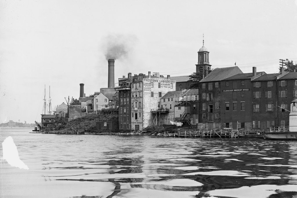
The view along the Portsmouth waterfront, taken from along Ceres Street looking toward the buildings on Bow Street, around 1900-1906. Image courtesy of the Library of Congress, Detroit Publishing Company Collection.

620_1900-1906 loc

The view in 2015:

620_2015
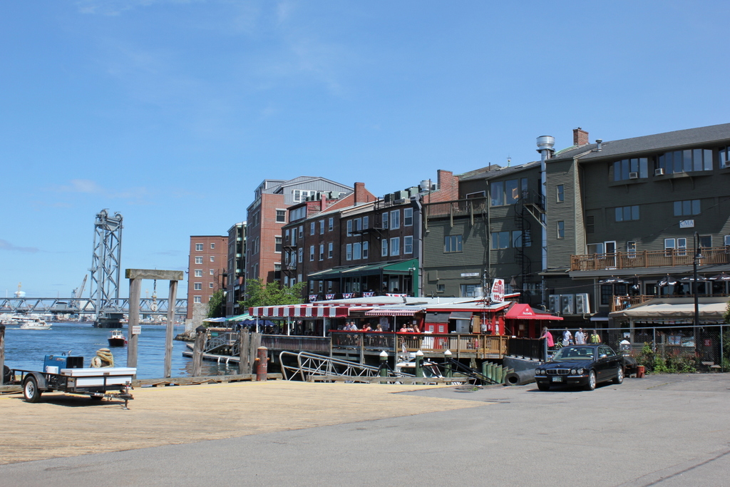
The angle here isn’t exactly the same,  but the two photos show some of the same buildings while demonstrating some of the change that has occurred along Bow Street.  The four buildings on the far right of the first photo are the same ones seen in the center of the 2015 view, and the two in the center of the first one still exist, but they are out of view from here, obscured by taller, modern buildings to the right of them.  The spire of St. John’s Church, which features prominently in the first photo, is also still there, although from this angle just the very top of the weathervane can be seen above the buildings.

Although many of the buildings are still there, though, the greatest change has been in their use; the waterfront of early 20th century Portsmouth was heavily industrial.  To the right were the offices for Eldredge Brewery, a prominent local brewery that opened in 1858 and operated for nearly a century, with a hiatus during the Prohibition era that came less than 20 years after the photo was taken.  In the center of the first photo, the white building served its purpose as both the home of Preston’s Laboratory and also as a large advertisement for its products.  It offered to customers such necessities as “Cologne Water,” “Tooth Powder,” and “Stedman’s Tu-Tha-Lin,” along with other “Simple remedies at all summer resorts.”  Although primarily industrial, it looks like there were people living here, too – notice the laundry hanging behind some of the buildings.

Today, the waterfront has been redeveloped as an upscale commercial district, with stores and restaurants replacing breweries and drug companies.  Martingale Wharf, the building once occupied by Preston’s Laboratory, is now a restaurant, one of several along this section of Bow Street that offer diners a view of the Piscataqua River.  On the left, in the background of both photos, is the Portsmouth Naval Shipyard.  although technically located in Kittery, Maine, the shipyard has played a major role in Portsmouth’s economy since it was established in 1800.  It is still in use today, specializing in submarine repair and modernization.

Lakefront at Center Harbor, NH

Looking east toward Lake Winnipesaukee from Main Street in Center Harbor, around 1906. Image courtesy of the Library of Congress, Detroit Publishing Company Collection.

593_1906c loc

The same view in 2015:

593_2015
These photos were taken from the same spot as the ones in the previous post, just a little to the right.  The original photos were probably intended to form a panoramic view, because the right side of the other photo and the left side of this one fit together seamlessly.  Center Harbor has long been a popular vacation spot, and the 1906 photo shows cottages and boathouses along the lake.  However, it is also interesting to see corn growing on prime lakefront real estate. Today, this property has been developed, and the Whittier Highway now passes through part of the former cornfield.  The stone wall, which can be seen here and also in this post, once ran along the road for a considerable distance to the south.  Today, much of it is gone, including the section here, which was removed to build the short cross street that connects the Whittier Highway with Main Street.  Further south there are some surviving remnants of the stone wall, although the farmland that it once enclosed has long since disappeared.

Center Harbor, NH

Looking north on present-day Route 25 toward Center Harbor, around 1906. Image courtesy of the Library of Congress, Detroit Publishing Company Collection.

591_1906c loc

The scene in 2015:

591_2015
As mentioned in some of the earlier Lake Winnipesaukee posts, when the first photo was taken the primary method of transportation to and around the lake was by railroad and/or steamboat.  In 1906, automobile ownership was still fairly rare, and the roads were not particularly well-suited for them, especially here in northern New England.  This road actually doesn’t look too bad, although at this point nearly all of the road traffic would have been horse-drawn carriages.  The Colonial Hotel is visible in the distance, and most of its guests would have arrived by the S.S. Mount Washington; the steamboat landing was just out of sight on the far right of the photo.

Today, the road is now Route 25, and it is a major route around the western end of Lake Winnipesaukee.  The Colonial Hotel has been gone for nearly a century, having been completely destroyed in a 1919 fire.  The house in the foreground must have been built soon after the first photo was taken, because its architectural style was common in the early 1900s.  The house and the trees now obscure the view of Red Hill from here, so only two identifiable features are visible in both photos: the Center Harbor Congregational Church, which is visible in the distance on the left, and parts of the old stone wall, which can barely be seen in the distance between the last two vehicles.

Paugus Bay, Weirs Beach, NH

Looking south toward Paugus Bay in Weirs Beach, from the present-day Route 3 bridge, around 1906:

588_1906c loc

Paugus Bay in 2015:

588_2015
This channel is the place where water flows out of Lake Winnipesaukee through Paugus Bay and eventually to the Merrimack River.  Originally, Paugus Bay was at a slightly lower elevation, and the channel was used by Native Americans for fishing.  They built stone weirs in a “W” shape across the channel to catch shad as they migrated from Winnipesaukee toward the ocean.  However, by the 19th century a dam was built in Lakeport, which raised Paugus Bay to the same level as Lake Winnipesaukee and flooded the old weirs.  Later on, the channel was dredged to allow navigation, effectively making Paugus Bay a part of Lake Winnipesaukee.

When the first photo was taken, this area was a popular tourist destination, and that has only increased over the years.  As seen in the two photos, the waterfront has become significantly more developed, especially on the right-hand side of the channel, which is now occupied by a number of boathouses.  I’m not sure if any of the buildings from 1906 are still around today; the ones on the left are clearly gone, but some of the boathouses in the distance on the right might survive, although it is hard to tell.  It is entirely possible that some of the cottages in the distance beyond the channel might still exist, but with the tree cover it is hard to tell from here.