The Oxbow from Mount Holyoke, Hadley Mass

The view looking southwest from the Mount Holyoke Summit House around 1900. Image courtesy of the Library of Congress, Detroit Publishing Company Collection.

563_1900c loc

The scene in 2015:

563_2015
This scene from the summit of Mount Holyoke was made famous in 1836 when artist Thomas Cole painted “View from Mount Holyoke, Northampton, Massachusetts, after a Thunderstorm,” a work also known as “The Oxbow” because of the prominent meander in the river.  Cole’s depiction of the scene is below:

Cole_Thomas_The_Oxbow_(The_Connecticut_River_near_Northampton_1836)
The top of Mount Holyoke has long been a sightseeing destination, starting even before Cole’s 1830s visit.  In 1821, a small cabin was built at the summit, which was replaced in 1851 by a much larger hotel, which still stands today.  The 2015 photo, and presumably the 1900 photo, were both taken from the porch that surrounds the building, and they reveal some of the changes that have occurred in the landscape over the past 115 years.  However, probably the most obvious change here occurred long before the first photo was taken, and not long after Thomas Cole painted his famous work.  In 1840, a flood broke through the narrow neck, giving the Connecticut River a more direct route downstream and turning the former riverbed into a lake.  It also made travel easier; traffic no longer had to follow the meandering river, and the 1900 scene shows the railroad tracks that had been built across what was once the river.  Today, Route 5 parallels the railroad tracks, and Interstate 91 crosses the Oxbow just a little further to the west.

When the 1900 photo was taken, the Oxbow played an important role in river commerce as a holding place for logs that were floated downstream.  Each spring in the late 1800s and early 1900s, logs from upstream in Vermont and New Hampshire would be floated down the river to the paper mills in Holyoke.  Since it is just a short distance upstream of Holyoke, the Oxbow made for a convenient holding place away from the main channel of the river.  The last such log drive occurred in 1915, and since then it has been used primarily for pleasure boats, with the Oxbow Marina located on the inside of the curve.  There are no dams between Holyoke to the south and Turners Falls to the north, so this section is one of the busiest on the Connecticut River for recreational boating.

First Congregational Church, Wilbraham Mass (1)

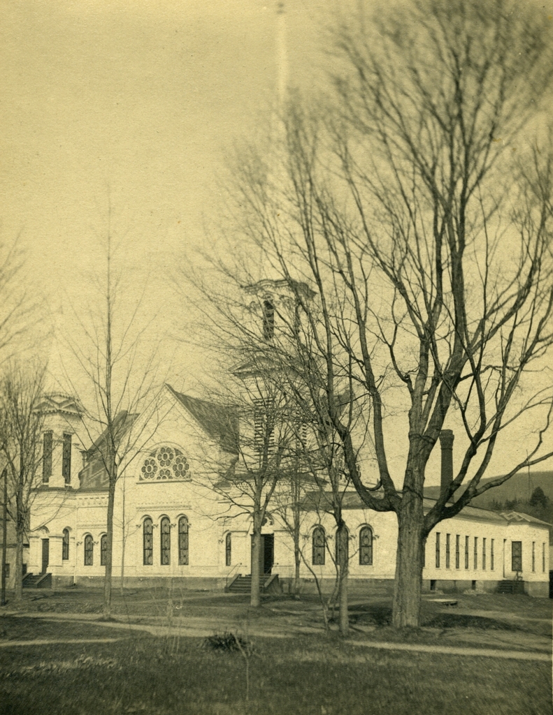
The First Congregational Church on Main Street in Wilbraham, probably around 1900. Image courtesy of the Wilbraham Public Library.

551_1900c wpl

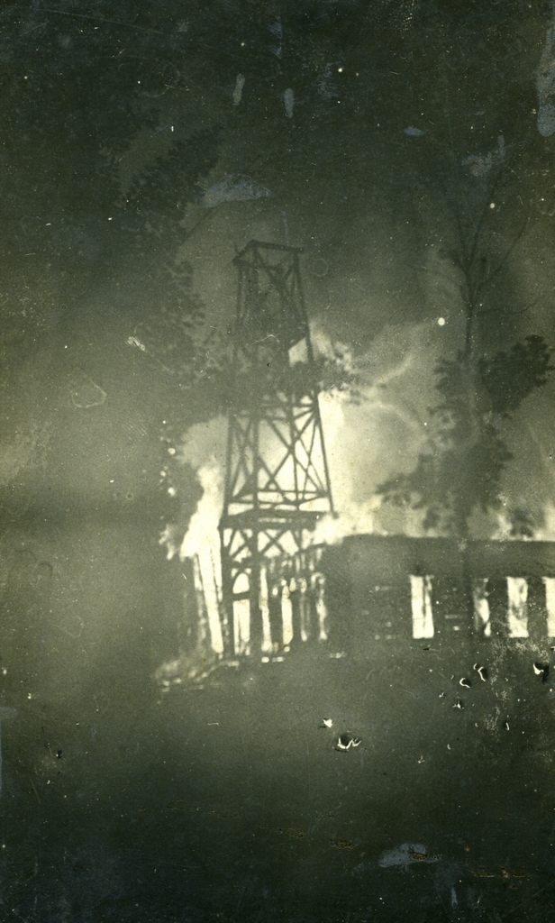
The church on fire after being struck by lightning on July 5, 1911. Image courtesy of the Wilbraham Public Library.

551_1911 wpl

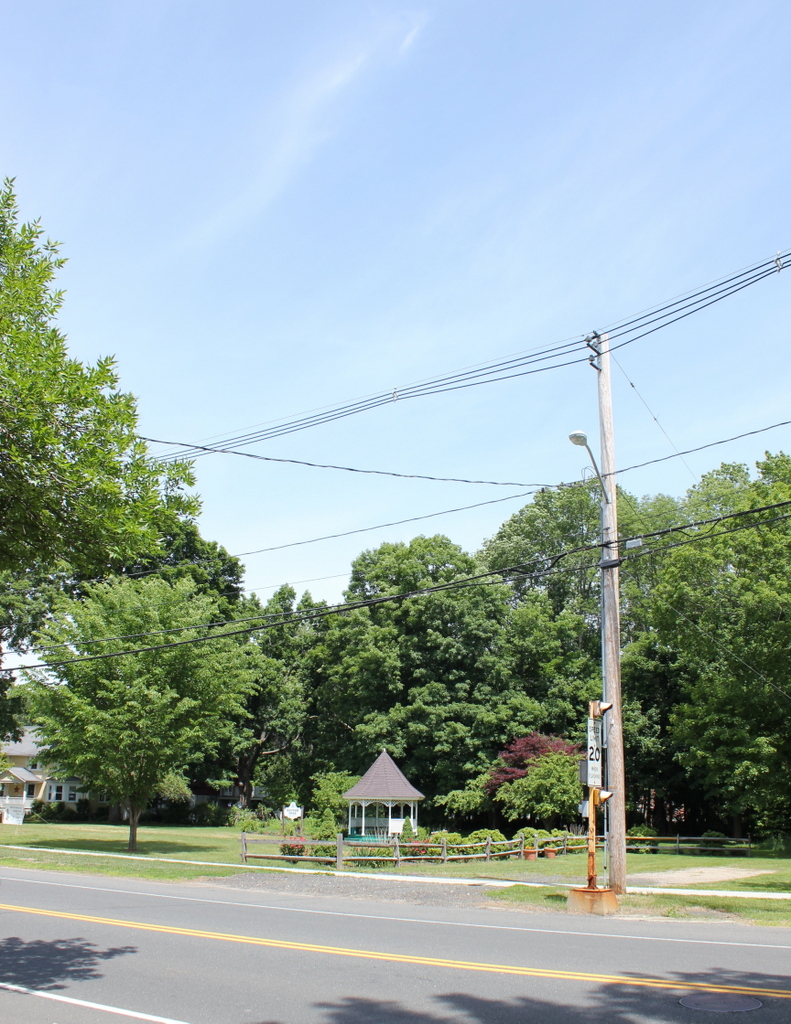
The site of the church in 2015:

551_2015 wpl
In many New England towns, one of the main features of the town center is a historic 19th century Congregational church, usually painted white and complete with a tall steeple.  However, that isn’t the case in Wilbraham, in part because of a series of fires that destroyed the first three meetinghouses that were located on this site.  The First Congregational  Church in Wilbraham was established in 1741 as an offshoot of the Springfield church.  As was the case in many other towns, however, the location of the meeting house became a major political issue.  In the days before automobiles, it was particularly advantageous to live near the meeting house, and in Wilbraham the settlers in both the northern part of town (present-day Wilbraham) and the southern part (present-day Hampden) wanted a meeting house location that was convenient for them.  Eventually, a compromise was reached and the meeting house was built on Wigwam Hill, halfway up a mountain in a sparsely-populated location that presumably only worked because it was equally inconvenient to everyone.

Eventually, however, it began to make sense to have a meeting house in the center of town, so in 1794 the church moved to this location on Main Street.  It wasn’t just the congregation that moved, though.  In true Yankee frugality, the building itself was moved down the mountain and over to this site, where it stood until 1857, when a new church building was completed.  The old meeting house was moved and used as a stable until 1877, when both generations of Wilbraham churches were destroyed in a fire.

The third meeting house, which is shown in the first photo here, was completed in 1878 and was used until 1911, for reasons that the second photo makes very clear.  On July 5, 1911, the steeple was struck by lightning, and the resulting fire consumed the entire church.  I don’t know how long it had been burning by the time the photograph was taken, but it is a ghostly image, with the skeletal remains of the steeple silhouetted against the flames in the background.

Following the fire, the church merged with the Methodist church to form the Wilbraham United Church.  They alternated between the rebuilt church at this site and the Methodist church next to the Wilbraham Academy campus until 1935, when the church here became their full-time home.  However, the congregation began to outgrow that building, so a fifth-generation Wilbraham church was built a short distance away in 1958; this building is still in use today.  The 1911 church was demolished in 1962, and today the site of the first four Congregational churches in Wilbraham is now a public park.

Soldiers and Sailors Memorial Arch, Hartford Connecticut

The Soldiers and Sailors Memorial Arch on Trinity Street in Hartford, around 1900-1910.  Image courtesy of the Library of Congress, Detroit Publishing Company Collection.

513_1900-1910 loc

The arch in 2015:

513_2015

Many cities and towns across the country have some sort of Civil War monument with a statue on top, but Hartford took it one step further and designed a pair of medieval-style towers connected by an arch.  The monument honors the approximately 4,000 Hartford citizens who served in the war, about 400 of whom never returned home.  It was dedicated in 1886, and spans Trinity Street not far from the State Capitol, which is off to the right, beyond the right-hand tower.  At the time that the first photo was taken, the section of road in front of the tower was a bridge over the Park River.  The bridge is still there, but the river has since been put underground and the grade was raised on the old riverbed.  Trinity Street has also changed – there are no longer any trolley tracks running down the middle, and because of how narrow the arch is, the street has been reduced to a single lane of one-way traffic.

Corning Fountain, Hartford Connecticut

The Corning Fountain in Bushnell Park in Hartford, around 1905. Image courtesy of the Library of Congress, Detroit Publishing Company Collection.

512_1905c loc

The fountain in 2015:

512_2015

The Corning Fountain was given as a gift to the city of Hartford in 1899 by John J. Corning.  It was designed by J. Massie Rhind, and features Native Americans representing local tribes, with a deer on top.  The city’s name literally means “hart ford,” as in “a place where deer cross a river,” so the hart or stag has become a symbol of the city.  Not coincidentally, the animal is also the symbol of The Hartford investment and insurance company.  The statue is located in Bushnell Park, a large public park that was created in the 1860s.  Prior to the construction of the park, this area was a fairly polluted industrial area.  Corning’s father operated a grist mill on the spot where the statue now sits, and the statue was given by his son in his memory.

Civil War Monument, Holyoke Mass

The Civil War Monument in Veterans’ Memorial Park in Holyoke, around 1900-1910. Image courtesy of the Library of Congress, Detroit Publishing Company Collection.

495_1900-1910 loc

The statue in 2015:

495_2015

Civil War monuments are a common feature in communities across the country, and Holyoke is no exception with their monument to the city’s 55 residents who died in the war.  What is rather unusual about this one, though, is the sculptor: former Confederate soldier Henry Jackson Ellicott.  It is also unusual in that most Civil War monuments feature the figure of a soldier, while Ellicott’s creation has Liberty holding a wreath atop the monument.  It was dedicated on America’s centennial, July 4, 1876, and today it remains at the center of Veterans Park, which now includes monuments for veterans of World War II, Korea, and Vietnam.

Not much of the surrounding neighborhood is visible in the first photo, but St. Jerome’s Church is clearly visible in the 2015 view.  Although mostly obscured by leaves, the church is there in the first photo; in fact, not only is it older than the monument, but it is older than the war itself.  The church was completed in 1860 to serve the growing population of mill workers, and was the first of many Catholic churches in Holyoke.  The statue includes a list of the 55 Holyoke men killed in the war, and among these are Irish names like Sullivan, McDonald, Cronan, and Donahue, so they very well could have been parishioners across the street at St. Jerome’s Church before they enlisted.

Venezian Monumental Works, Springfield Mass

The Venezian Monumental Works building on State Street in Springfield, around 1938-1939. Photo courtesy of the Springfield Preservation Trust.

485_1938-1939 spt

The building in 2015:

485_2015

This building is located right next to the architecturally similar building at 1579 State Street, which was probably photographed on the same day as this one.  However, while the former Frank’s Service building has long been shuttered, the Venezian Monumental Works is still in business.  The company is actually substantially older than even the first photo; it was established in 1882, when the Pine Point neighborhood was on the remote outskirts of the city.  Since then, the neighborhood has grown, which has presumably increased demand for headstones, and it also doesn’t hurt that they are located right next to St. Michael’s Cemetery.  Today, the building has doubled in size, but the original section is still visible on the left side.