Back Bay, Boston

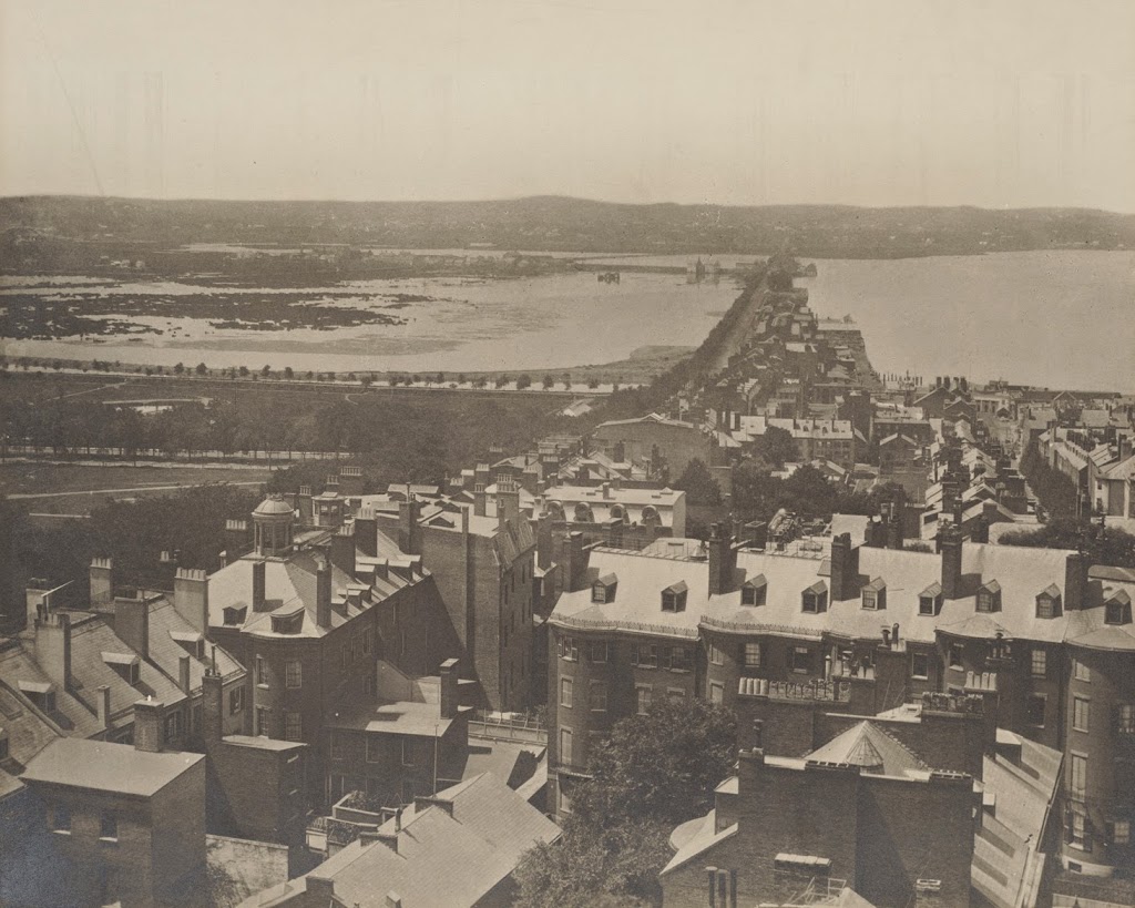
The view of the Back Bay, from the top of the State House, in 1857. Image courtesy of the Boston Public Library.

065_1857-2Bbpl

The same view from the same spot, between 1900 and 1910. Image courtesy of the Library of Congress, Detroit Publishing Company Collection.

065_1900-1910-2Bloc.tif

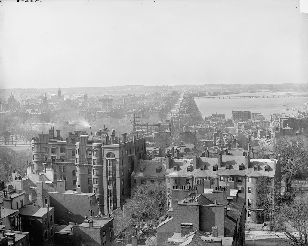
This post is a bit unusual, since I don’t have a modern-day view of the scene, but I thought that the differences between these two photos, taken only about 50 years apart, was particularly compelling, and illustrates just how much of Boston is built on reclaimed land.  If I did have a present-day photo, it would show the John Hancock Building, the Prudential Tower, Hynes Convention Center, the Massachusetts Turnpike, and one of the most expensive neighborhoods in Boston.  Yet, less than 160 years ago it was just a heavily polluted mud flat.

To help identify a few prominent locations in the swamps of 1857, the row of trees at the end of the water is present-day Arlington Street, and the road built across the water is Beacon Street, originally built in 1814 as a dam and toll road.  The dam was intended to use the power of the outgoing tides for factories in the area, but it had the unintended consequence of preventing the mud flats from being washed out twice daily by the tides, leading to a shallow basin filled with sewage, garbage, and other pollution. Another dam connected Beacon Street to the point of land in the distance on the left.  The left-hand side of the dam ended at the present-day intersection of Massachusetts Avenue and Commonwealth Avenue.  In the extreme distance of the 1857 photo, Beacon Street reaches the mainland at present-day Kenmore Square.

Most of the Back Bay up was filled in only a short time after this photo was taken, and completely filled in by 1882.  The Fenway section (so-called because of the swamps, or “fens” in the area) was mostly finished by 1900, putting the finishing touches on the Boston that we now know today.

North End, Boston

The view of the North End in Boston, from Boston Harbor, around 1930. Image courtesy of Boston Public Library, Leslie Jones Collection.

050_1930-2Bbpl

The scene in 2021:

These two photos show the North End of Boston from across the harbor at Charlestown Navy Yard. Many of the buildings in the North End are still there today, but the Boston skyline behind it has been completely changed – the once prominent Custom House Tower now blends in with the rest of the skyscrapers in downtown, although Old North Church in the foreground still stands out among the low-rises in the North End.

Paul Revere House, Boston

Paul Revere’s House in Boston, around 1898. Image courtesy of Boston Public Library.

049_1898c-bpl

The house in 2014:

049_2014

Built in 1680, Paul Revere’s house is the oldest building in downtown Boston, and was owned by Paul Revere from 1770 to 1800. He actually added a third floor, as seen in the 1898 photo, but shortly after the photo was taken, the house was purchased by one of Revere’s descendants and restored to its 1680 appearance. Despite all of the modifications, it is estimated that about 90% of the structure is original to 1680, which is impressive, considering how different it looks in the two photos.

Long Wharf, Boston

Long Wharf in Boston, around 1910. Image courtesy of Boston Public Library.

044_1910c-2Bbpl

Long Wharf around 1930. Image courtesy of Boston Public Library, Leslie Jones Collection.

044_1930c-2Bbpl

The same view in 2006:

044_2006

Boston’s Long Wharf was originally much longer than it is now, although the wharf didn’t get shorter – the city grew outwards. At the beginning of the 18th century, a longer wharf was needed to extend further into the harbor, in order to accomodate deeper oceangoing ships. Originally, it started where Faneuil Hall is today, but as time went on, the city expanded by filling in Boston Harbor, sometimes with dirt and rocks, and sometimes with sunken ships and construction debris. Either way, the city ended up filling in much of the space between Long Wharf and other wharves, and the city built up around it. In the 1930’s, the wharf was much the same as it is today, but at the time this part was used by the United Fruit Company, hence the cargo ships. Today, the cargo ships are gone, replaced by ferries to other parts of Boston and surrounding communities. Some of the older buildings remain, including the granite 1848 Custom House Block, which is visible on the far left of both photos.  The cargo ships in the two photos, however, do not exist anymore.  I don’t know what happened to the Vera, the steamer in the first photo, but a ship of the same name was sunk by a German U-boat in World War I.  The same fate definitely did happen to the ship in the 1930 photo, the Oriskany, though; it was sunk by a U-boat in 1945 off the coast of England.

Union Oyster House, Boston

Union Oyster House in Boston, sometime in the 19th century. Photo courtesy of Boston Public Library:

Restaurants

The historic building around 1898. Photo courtesy of Boston Public Library:

265_1898c-2Bbpl

In 1930, courtesy of Boston Public Library:

265_1930-07-28-2Bbpl

Sometime between 1934 and 1956. Photo courtesy of Boston Public Library, Leslie Jones Collection.

265_1934-1956-2Bbpl

The Union Oyster House in 2010:

265_2010

The above four photos show over 100 years of the history of the oldest restaurant in the United States, the Union Oyster House in Boston.  Although the restaurant opened in 1826, the building itself is far older, having been built around 1704.  The second floor was once used as the publishing office of the Massachusetts Spy in the 1770’s, and in 1796 the future King Louis Philippe of France lived in exile, also on the second floor.  Since becoming a restaurant, the Union Oyster House (originally Atwood & Bacon Oyster House, as seen in the 1898 photo) has served many notable patrons, including Daniel Webster, John F. Kennedy, and other members of the Kennedy family.

Fenway Park, Boston (3)

Fenway Park as it appeared in 1912, the year it opened. Image courtesy of the Library of Congress, Bain Collection.

037_1912-2Bloc

Roughly the same view, in April 2006:

037_2006

For the first 35 years of its existence, the Green Monster wasn’t green – it was essentially a giant billboard.  And the original Green Monster seats weren’t on top of it – they were at the base, atop Duffy’s Cliff – a steep incline leading up to the wall that was usually in play and was mastered by Boston left fielder Duffy Lewis.  For this particular photo in 1912, the bleacher seats were temporarily constructed to handle the increased crowds for the 1912 World Series.  The original wooden 1912 wall is gone – it was replaced in 1934 by the present-day wall, and the incline was eliminated, making left field several feet below the level of Landsdowne Street, which is located directly behind the Monster.  The other major feature in the 1912 photo – the wooden left field bleachers – are also gone.  They burned in 1926, and since fans weren’t exactly clamoring to get through the turnstiles at Fenway in the 1920’s, they were not replaced until Tom Yawkey purchased the team and extensively renovated the park to its current configuration in 1934.  See posts #1 and #2 to see similar views from 1912 and the present-day.