Old South Meeting House, Boston

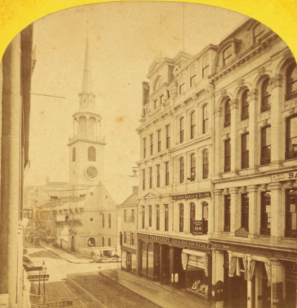
The view looking north on Washington Street toward Old South Meeting House, sometime shortly before the Great Boston Fire of 1872. Photo courtesy of New York Public Library.

079_1870c-2Bnypl

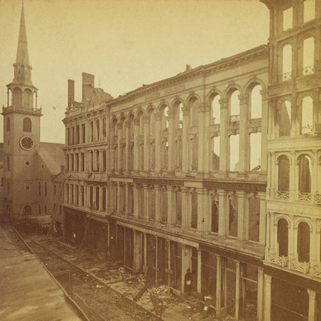
The same view, in the immediate aftermath of the fire. Photo courtesy of New York Public Library.

079_1872-2Bnypl

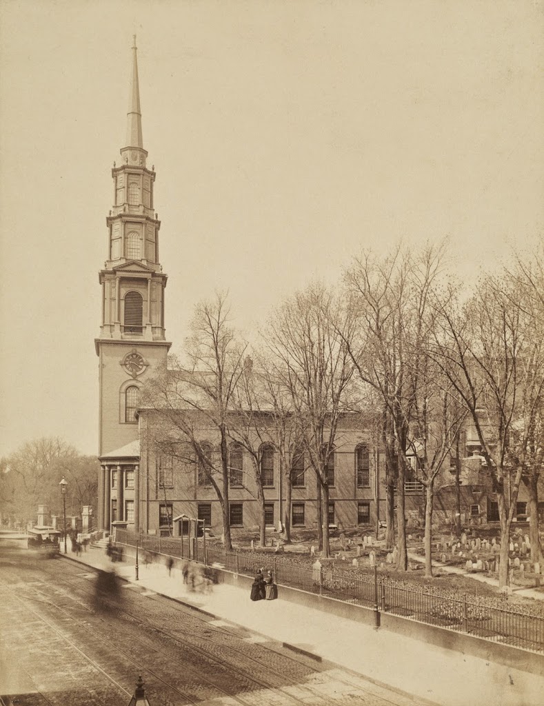
Around 1875. Photo courtesy of Boston Public Library.

079_1875c-2Bbpl

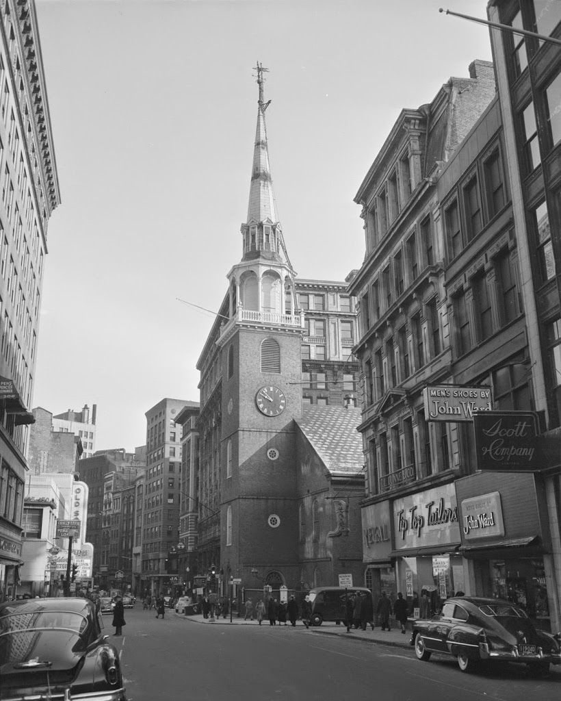
Sometime in the late 1940s or early 1950s. Photo courtesy of Boston Public Library.

1940s

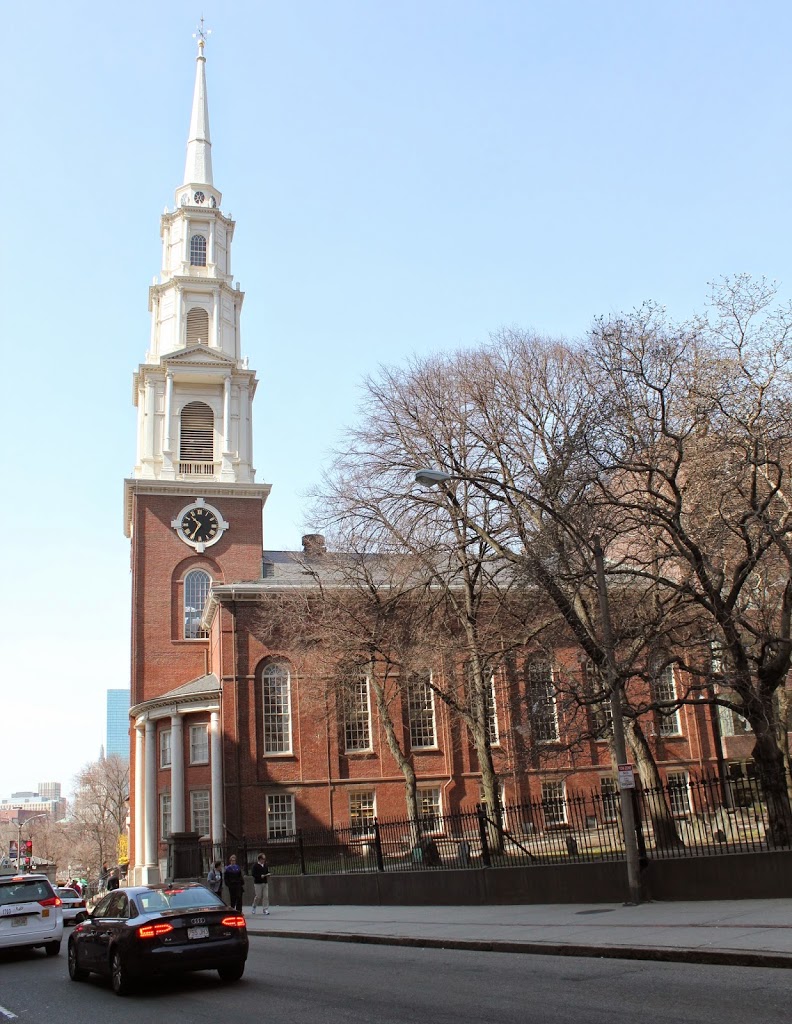
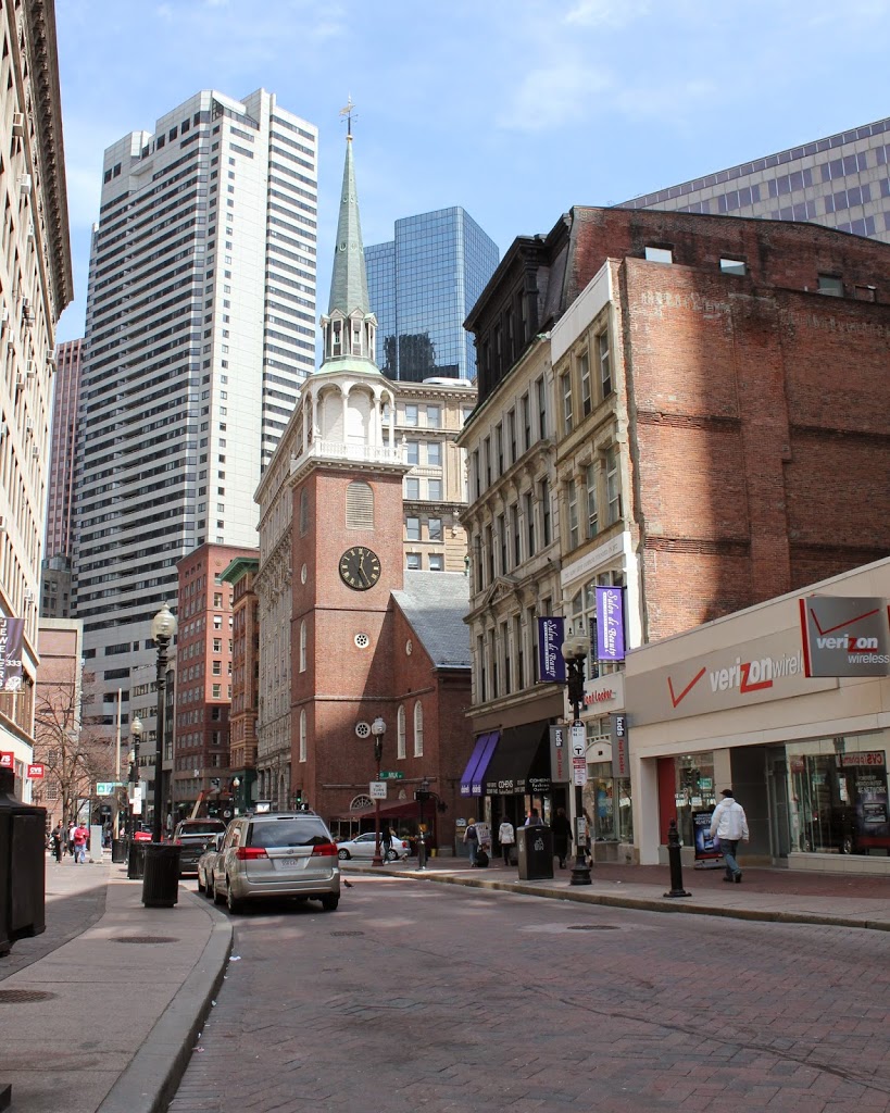
The same scene in 2011:

079_1940s-2011

The Great Boston Fire of 1872 was the most disastrous fire in Boston history.  It came just a year after the Great Chicago Fire, although Boston’s fire couldn’t hold a candle to Chicago’s (pun intended) when it came to the death toll and property losses.  Boston’s fire killed about 30, destroyed 776 buildings, and caused about $73.5 million in damages (about $1.4 billion in 2013 dollars).  Chicago, by comparison, killed 200-330, destroyed 17,500 buildings, and caused about $222 million in damage (around $4.2 billion today).

Still, Boston’s fire was extensive in its damage – it destroyed much of downtown Boston, including sections of Washington Street as seen in the first two photos.  However, the historic Old South Meeting House, built in 1729, survived thanks to volunteers using wet blankets to fend off the flames.

By the time the 1875 photo was taken, Boston was rebuilding, but so was Old South Church.  Because the fire destroyed so many homes, people began relocating to the newly filled in Back Bay, and the church followed them, constructing the oxymoronically-named New Old South Church at Copley Square.  No longer needed, the historic building was sold and was to be demolished.  However, given the building’s role in the events leading up the the Revolutionary War, Bostonians rallied to preserve it, making it one of the first such buildings to be preserved for its historical significance.

In the last two photos, most of the buildings in the foreground remain the same, although the skyline in the background has changed.  The building immediately to the right of the church is actually the same in the last three photos, and it looks similar to the burned-out building that occupied the spot before the fire.  I don’t know whether it is the same facade, or if it was just rebuilt with a similar style, but at the very least the existing building dates to the immediate aftermath of the fire.  As for the church, today it functions as a museum, although the congregation holds its annual Thanksgiving service at the building.

Central Congregational Church, Boston

Central Congregational Church at the corner of Berkeley and Newbury in Boston, around 1904. Image courtesy of the Library of Congress, Detroit Publishing Company Collection.

070_1904c-2Bloc

The same building, now the Church of the Covenant, in 2015:

070_2015

The church was built in 1867, one of the first in Boston’s then recently filled in Back Bay.  By the time the 1904 photo was taken, the Back Bay looked very much like it does today, albeit with fewer skyscrapers.  Still, though, many of the low-rise residential buildings from 1904 are still there, including a few visible in both of these photos.  At the time of its construction, the church was the tallest building in Boston, and retained its title until the construction of the Custom House Tower in 1915.

Boston Skyline

The view of Boston from the harbor, in the early 1930s. Image courtesy of Boston Public Library, Leslie Jones Collection.

069_1930c-2Bbpl

The view in 2013:

069_2013

Boston’s skyline has changed a lot in the past 80 years, but there are still some recognizable buildings in both photos.  The Custom House Tower, the lonely skyscraper in the first photo, is still among the tallest buildings in downtown Boston, but it no longer stands out like it did from when it was built in 1915 until the 1970’s.  Part of the reason why Boston’s skyline got off to a slow start was because, for many years, the city had a 125 foot limit on any buildings; the Custom House was able to skirt these requirements because it was a federally-owned structure.  One of the other prominent building in the 1930’s photo is the John W. McCormack U.S. Post Office and Courthouse, another federally-owned building that is still standing, but barely visible in the 2013 photo.  The building was built between 1930 and 1933, which establishes the earliest that the photo could have been taken.

Boston Navy Yard Dry Dock

The USS S-48, entering Dry Dock 2 at Boston Navy Yard in 1929. Photo courtesy of Boston Public Library, Leslie Jones Collection.

068_1929-2Bbpl

The same view in 2021:

Although no longer an active military base, this part of Boston Navy Yard looks much the same as it did in the 1920s, thanks to its preservation as part of the National Park Service’s Boston National Historic Park.  The yard was opened in 1801, and was very active during World War II, when it built a number of destroyers and other smaller warships.  It closed in 1974, and was then turned over to the NPS.


The submarine in the first photo is the USS S-48, which was launched in 1921, in the days before the Navy gave real names to its submarines.  Even though it was only a few years old when the photo was taken, the S-48 had already experienced several mishaps; during builder’s trials, a manhole cover was left unsecured, which is generally a bad thing on a submarine.  A few years later, it grounded off the coast of New Hampshire and was out of service until a few months before this picture was taken.  The S-48 would serve in World War II, but by then the obsolete submarine was used primarily for training purposes, and was scrapped shortly after the war ended.

Corner of Blackstone and Hanover Streets, Boston

The corner of Blackstone Street and Hanover Street, in 1956. Photo courtesy of Boston Public Library, Leslie Jones Collection.

1950s

The same corner in 2011:

067_2011

There’s something rather depressing about comparing these two photos – the bustling marketplace, contrasted with the shuttered storefronts and empty streets.  However, the appearance neighborhood as a whole has improved significantly since 1956 – the first photo was actually taken right in front of the Central Artery – the massive elevated highway that was eventually replaced by the much-maligned yet more aesthetically pleasing Big Dig.  Where I was standing to take the 2011 photo is right about where the highway ran through – if I had taken the photo 10 years earlier, the buildings in the foreground would’ve been barely visible.

I hadn’t seen the 1956 photo before taking this photo; what drew me to the building was the fading 19th century advertisements still visible on the bricks.  The two most prominent are for Bostonia Cigars (top and right-hand side), and W.P.B. Brooks & Co. Furniture Carpets &c.  I couldn’t find out much about either company, but it appears both from the appearance of the advertisements and also some quick online searches about the companies that they existed in the late 19th and early 20th centuries.

The building itself, which was constructed around 1835, is actually the same building that has the Boston Stone mounted on its wall, on the opposite side of where this photo was taken.  Behind it is the Blackstone Block, a rare group of buildings from the 18th and 19th century that still maintains the original 1600’s street network.  It is completely surrounded by much newer construction, but it is a small enclave of historic structures.  On the opposite side of this area is one of Boston’s oldest buildings, the home of the Union Oyster House.

This building itself actually used to have more floors, but at some point before the 1956 photo it was trimmed down to just three.  However, recent photos of this same building taken in the past year have shown that a couple more floors have actually been added on to the top of it, which would suggest that its future is brighter than the boarded up storefronts and deserted streets would seem to suggest.

John Hancock Memorial, Boston

John Hancock’s grave in the Granary Burying Ground, around 1898. Photo courtesy of Boston Public Library.

The same site in 2023:

Although John Hancock died in 1793, his grave wasn’t memorialized until 1896, about 2 years before the first photo, when the monument was dedicated.  The graveyard itself remains much the same as it was in 1898, down to the fence between it and the surrounding buildings, but the buildings themselves are very different from the ones at the end of the 19th century.