Park Street Subway Station, Boston (3)

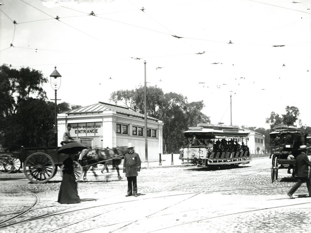
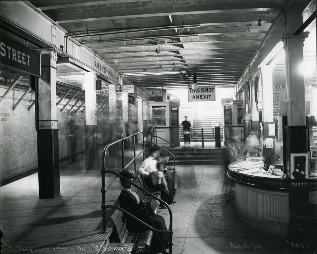
The outbound platform at the Park Street station in Boston, on August 5, 1901. Image courtesy of the City of Boston Archives.

693_1901-08-05 coba

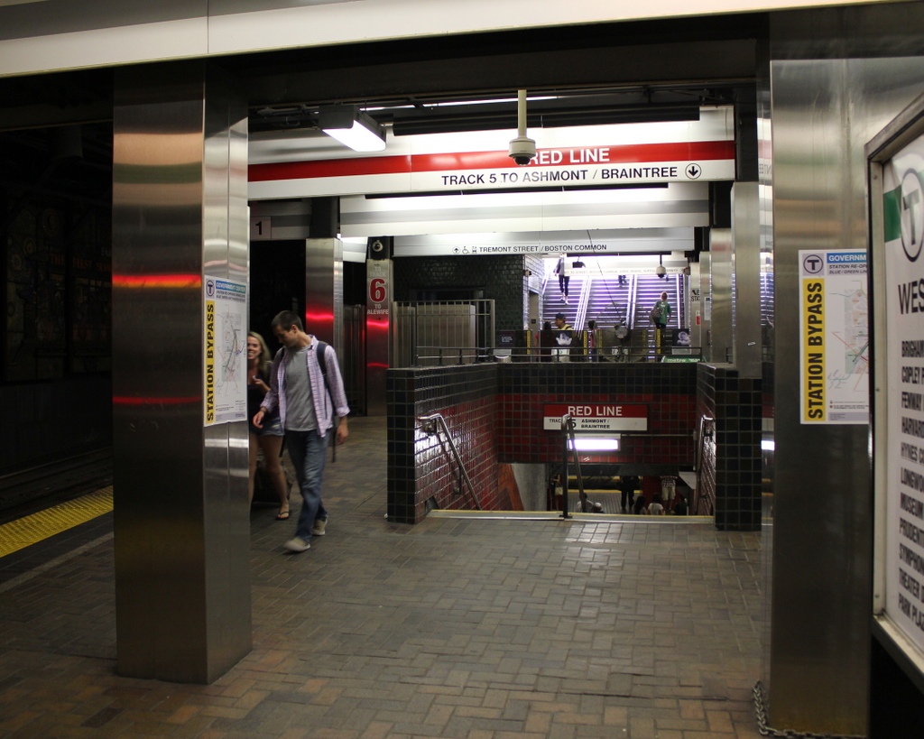
The same station platform in 2015:

693_2015
As mentioned in previous posts showing the interior of Park Street Station here and here, Park Street was one of the first two subway stations in the country, along with Boylston about a quarter mile to the south, when it opened in 1897.  The photos in those two posts show the station before it opened, but this 1901 photo here is interesting because it gives a glimpse into the day-to-day activity inside the station.  Because of the long exposure time, most of the figures are blurred, except for the woman seated on the bench in the foreground.  Another fairly clear figure is the man standing at the entrance in the distance.  In the years before turnstiles, passengers would purchase a ticket at one of the kiosks, and then give the ticket to the attendant at the gate, similar to the way movie theaters operate.  There were also separate entrances for entering and exiting passengers, hence the “This Is Not An Exit” sign above the gate.

Park Street station, along with the rest of the Tremont Street Subway, was originally designed for trolley cars rather than rapid transit subway cars, and this distinction can still be seen today in the trolleys that run on the Green Line, as opposed to the more conventional subway cars on the other three lines.  However, from 1901 to 1908, the tunnel was also used by the Boston Elevated Railway, so the station platforms had to be retrofitted to accommodate the higher subway cars, which is why the first photo shows wooden platforms along the track.  During this time, these cars used the two outer tracks in the station, while trolleys used the inner two tracks.  In 1908, the Boston Elevated Railway was rerouted through its own tunnel under Washington Street, which today forms the downtown section of the Orange Line.

A few years later, in 1912, the Boston Elevated Railway built another subway line through Park Street, forming what is now the Red Line.  Separate platforms were built underneath the existing station, with stairs now located around the spot where the passengers were waiting on the benches in the 1901 photo.  Other significant changes to the station over the years have included lengthening the Green Line platforms, as well as some of the more cosmetic changes that are seen in the 2015 photo, such as tiles on the floor and sheet metal covering the original columns.

Boston and Maine Station, Boston

The Boston and Maine Railroad station at Haymarket Square in Boston, around 1894. Image courtesy of the City of Boston Archives.

689_1894c coba

The Boston City Hospital Relief Station, on the site of the former railroad station in 1905. Image courtesy of the City of Boston Archives.

689_1905-11-05

The location in 2015:

689_2015
Of the eight major railroads that served Boston in the late 1800s, the Boston and Maine came the closest to the downtown area, with its depot at Haymarket Square. It was opened in 1845, and over the years Boston and Maine became the dominant railroad in northern New England, with many of its lines converging here.  However, because there were four different railroads that had their own stations within a few blocks of here, the companies built North Station in 1893, about 300 yards up Canal Street from here.

The old station had been built in the early years of railroad travel, and it stood until 1897, when it was demolished to make way for a new type of rail travel.  Boston’s Tremont Street Subway was the first subway tunnel in the country, and the northern entrance of the tunnel was built on the site of the station.  From here, the tracks ran along the surface between Canal and Haverhill Streets, where the station platforms used to be.  The only new building on the site was the Boston City Hospital Relief Station, as seen in the 1905 photo.  It was built in 1902 as a branch of the Boston City Hospital, in order to provide emergency services in the downtown area, and it stood until the early 1960s.

Today, there isn’t much left from either of the first two photos.  A few of the buildings on Canal Street are still standing, such as the one on the far left in both the 1891 and 1905 photos.  It is barely visible on the left of the 2015 photo, above the bus in the foreground.  Haymarket Square itself is completely changed, though, through a series of urban renewal projects in the 20th century.  To the left is a parking garage, with the Haymarket Square subway station underneath it.  On the right-hand side of the photo, the elevated Central Artery once passed through here.  Built in the 1950s, it cut a swath through downtown Boston until 2003, when the highway was rerouted through the Tip O’Neill Tunnel as part of the Big Dig.  The building under construction in the background is being built on land that the Central Artery once passed through.

North Station, Boston

The original North Station on Causeway Street in Boston, around 1893-1899. Image courtesy of the Library of Congress, Detroit Publishing Company Collection.

688_1890-1899c loc

The scene in 2015:

688_2015

The scene in 2024, showing recent development in front of TD Garden:

Oliver Wendell Holmes once wrote about Boston as being “The Hub of the Solar System,” and although he was using the phrase sarcastically, the city would soon become the transportation hub of New England.  By the late 1800s, there were at least eight railroads that radiated outward from Boston, with each one having its own separate terminal.  However, these eight different stations were both inconvenient for passengers and also a poor use of valuable land.

Here in the northern part of the city, four different railroads each had their own stations within a several block radius: the Boston and Maine, Boston and Lowell, Eastern Railroad, and the Fitchburg Railroad.  All but the Boston and Maine had their passenger terminals in a row here along Causeway Street, so in 1893 the North Union Station opened here, consolidating all four railroads into one building.  It was designed by Shepley, Rutan and Coolidge, a prominent Boston architectural firm that would design South Station six years later, when the four south side terminals were likewise consolidated.

The original North Station was demolished in 1927 to build the Boston Garden, which also included a reconstructed station.  Boston Garden was home to the Boston Bruins from 1928 to 1995, and the Boston Celtics from 1946 to 1995, and the it was demolished in 1998, three years after the completion of the present-day TD Garden.  Today’s North Station is located directly underneath the TD Garden, although today none of the four railroads that opened the first station even exist anymore.  Amtrak has only one passenger route, the Downeaster, that stops here, although it is the terminal for four of the MBTA Commuter Rail lines.  Above the station, the Bruins and Celtics still play here, just behind the spot where the Boston Garden once stood.

Boylston Station, Boston

The Boylston subway station, at the corner of Tremont and Boylston Streets in Boston, on August 12, 1897. Image courtesy of the City of Boston Archives.

687_1897-08-12 coba

The station in 2015:

687_2015
The first photo captures the ending of one era and the beginning of another.  Just a few weeks after the photo was taken, the trolleys that are seen here on congested Tremont Street would be moved underground, giving Boston the distinction of having the country’s first subway tunnel.  The first two stations were Park Street, just over a quarter mile to the north, and this one here at Boylston Street, in the southeast corner of Boston Common.  The project was a major civil engineering milestone, but it didn’t come without tragedy.  At this location earlier in the year, a leaking gas line in the work area under the intersection caused an explosion that killed six people.  The explosion is explained further in this post, which features photos that were taken diagonally across the street from here.

Today, the view really hasn’t changed too much.  The trolleys on the Green Line are still running under this intersection, the distinctive station entrances are still here, as is Boston Common in the background.  Even in the 19th century, this intersection of Boylston and Tremont streets was busy, necessitating the police officer in the left center of the 1897 photo.  The slow shutter speed of the camera has blurred most of the traffic around him, but he is standing perfectly still, posing for the photographer as trolleys, carriages, and pedestrians pass by.  It is still a major intersection today, albeit without the nostalgia of a 19th century officer directing traffic on a cobblestone street.

Arlington Station, Boston

The entrance to the Arlington subway station, taken from the Boston Public Garden in front of the Arlington Street Church, on March 17, 1937. Image courtesy of the City of Boston Archives.

680_1937-03-17

The scene in 2015:

680_2015
When the present-day Green Line subway tunnel was built in 1897, it only went as far west as Arlington Street; from here, the trolleys came to the surface (as seen in this post) and traveled along the center of Boylston Street through the Back Bay.  However, in 1914 the subway was extended west to Kenmore Square, and from here the closest stations were either a third of a mile to the east at Boylston, or an equal distance to the west at Copley Square.  This gap was resolved in 1921 when Arlington station opened here, with the original entrance being located in the Public Garden at the corner of Arlington and Boylston Streets.

The station has been renovated over the years, and the Public Garden entrance no longer exists, but many of the surrounding buildings from nearly 80 years ago are still standing.  The most prominent is the 1861 Arlington Street Church, which is partially blocked in both photos by the back of a statue and monument honoring William Ellery Channing, a Unitarian minister who was once the pastor of the congregation that later built the church.  Many of the buildings along Boylston Street in the distance are also still there today, but the skyline behind them has dramatically increased; some of the skyscrapers visible today include the old John Hancock Building, the new John Hancock Tower, and the Prudential Tower.

Boylston Street from Gloucester Street, Boston

Looking west on Boylston Street from the corner of Gloucester Street, on August 6, 1912.  Image courtesy of the City of Boston Archives.

667_1912-08-06 coba

Boylston Street in 2015:

667_2015
The first photo here appears to be documenting the early stages of the work on the Boylston Street Subway, today’s Green Line of the MBTA.  Prior to 1912, the present-day Green Line was only underground from North Station to Arlington, emerging onto Boylston Street at the Boston Public Garden, as seen in this post.  From there, it ran through the Back Bay in the center of Boylston Street, as seen here.  Because of increasing congestion, though, the trolley line was moved underground in 1914.  The new tunnel ran from Arlington Street to Kenmore Square, where it came to the surface in the median of Commonwealth Avenue just east of the square.  I’m not entirely sure what the workers are doing here, but they appear to be doing some sort of excavation on the tunnel – notice the planks in the otherwise dirt road, which probably cover the work that was being done.  In the meantime, the trolleys needed to continue running, so the 1912 scene shows a Reservoir-bound car (today’s “C” Line) passing through the construction area.

Today, Green Line trains still run under this spot in the tunnel that the 1912 workers were building, and on the surface not much has changed on the right-hand side.  Along the mile-long stretch of Boylston Street in the Back Bay, the north side of the street is primarily late 19th and early 20th century low-rise construction, while the south side is almost entirely new.  This contrast can be seen here, as nearly all of the buildings from 1912 are still standing on the right, including the three-story commercial building in the foreground.  It was built in 1905, and in the first photo the corner storefront is occupied by The Henley-Kimball Company, a car dealership that sold Hudson cars.  It was one of many car dealerships along Boylston Street; an awning further down the street advertises for Chalmers, and there are also window signs for Stutz Motor Company and Michelin Tires.

The left (south) side of Boylston Street, however, is significantly different.  In 1912, there were no buildings here; instead, this area was the site of a large rail yard for the Boston & Albany Railroad.  The yard took up the south side of Boylston for three blocks, from Exeter Street to Hereford Street, but over time the land became too valuable to simply use for a rail yard.  The Massachusetts Turnpike now runs through the site of the former yard, and a number of buildings have been built on top of it, including the Hines Convention Center, which can be seen on the far left of the 2015 photo.