Trolley Barn, Springfield Mass

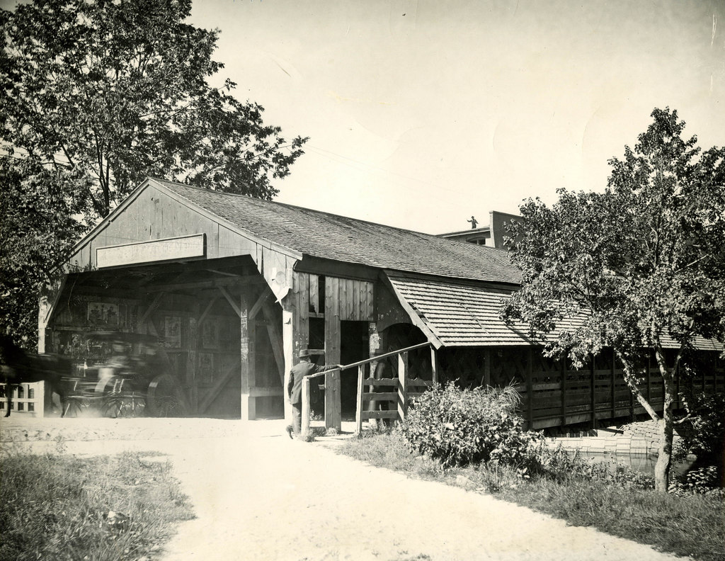
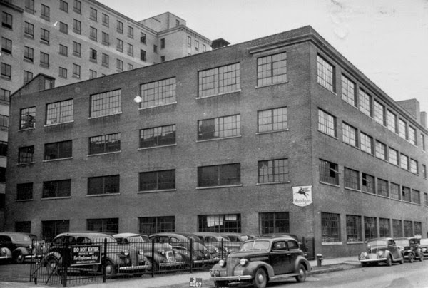
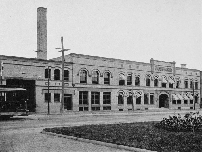
The Springfield Street Railway trolley barn at the corner of Main and Carew Streets, around 1905. Photo from Springfield Present and Prospective (1905).

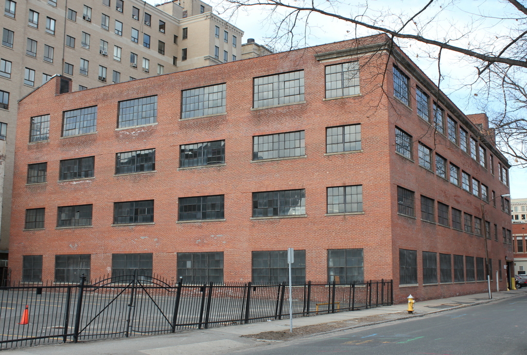
The building in 2023:

The late 19th century saw a dramatic growth in suburbs, and this was fueled in part by the development of inexpensive forms of mass transit such as street railways.  Although most commonly associated with electrified trolleys, these originally started as horse-drawn cars on rails.  This was the case in Springfield, where the Springfield Street Railway opened in 1870.  The original line was a single track that ran about 2.5 miles from Hooker Street in the North End, where the stables were located (not coincidentally, this is now the site of the PVTA headquarters), south along Main Street to State Street, and then along State Street to Oak Street, just past the Armory.  The line was served by four cars and 24 horses, and rides were eight cents each or 16 for a dollar.

It must have been popular, because within four years the network was expanded east on State Street to Winchester Square, and south on Main Street to the Mill River.  More lines were later opened, along Maple and Central Streets to the Watershops, and other lines to Indian Orchard, Brightwood, and along Worthington Street.  Meanwhile, fares continued to drop, first to six cents and then to five.  The biggest change, however, came in 1891, when all of the lines were electrified to run trolleys instead of horse-drawn cars.

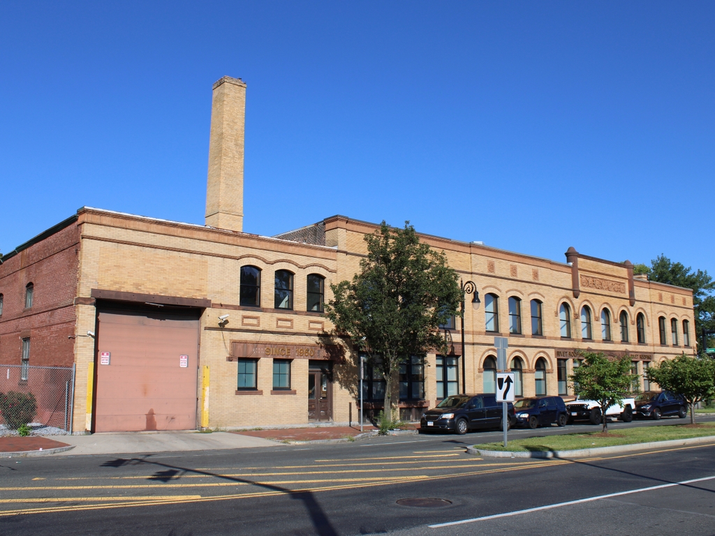
By the end of the 19th century, the network was extended to Longmeadow, East Longmeadow, and Feeding Hills, and connections were made to street railway networks in Holyoke, Westfield, Northampton, Palmer, and Hartford.  As a result of the growth of the company, this building was built in 1897 as a new headquarters, at the corner of Main and Carew Streets in Springfield’s North End.  At the time that the first photo was taken, the company operated almost 94 miles of track, with 48 of those miles in Springfield, and operated 227 cars on the lines.

However, as was the case with trolley lines around the country, the Springfield Street Railway wouldn’t last.  Just as electrified trolleys replaced horse-drawn cars, automobiles and buses replaced the trolleys.  The trolley barn (the name itself is a holdover from when the horses were housed in literal barns) is still there, and still looks very much the same as it did over 100 years ago.

Railroad Station, East Longmeadow Mass

The railroad station near the center of East Longmeadow in 1910. Photo courtesy of the East Longmeadow Historical Commission.

476_1910-03-14 elonghistcom

The station in 2015:

476_2015

The station in 2023:

Today, East Longmeadow doesn’t have any active rail lines, but a century ago the Armory Branch of the New York, New Haven & Hartford Railroad passed through the town.  The line connected East Hartford and Springfield, and passed by the Watershops of the Springfield Armory, which gave the branch its name.  In East Longmeadow, it provided a way for the many quarries in town to ship their stone, and it also provided a method of transportation in the days before automobiles.  However, the branch was never a major route, and was abandoned by the 1980s.  Today, most of the line is still abandoned, but a 1.6 mile section in East Longmeadow is now the Redstone Rail Trail, named for the quarries that once used the line.  The station, which opened in 1876, is located at the northern terminus of the trail, and although it has clearly seen better days, it is still instantly recognizable from the 1910 photo.

2023 Update: As shown in the third photo, station has since been restored, and it reopened in 2021 as an ice cream shop.

Put’s Bridge, Springfield Mass

The old covered bridge across the Chicopee River from Springfield to Ludlow, taken from the Springfield side in 1897. Photo courtesy of the Hubbard Memorial Library.

473_1897 hubbardmemlib

The present-day bridge in 2015:

473_2015

Alternately called Putts Bridge, this spot at Wallamanumps Falls on the Chicopee River has long been the site of a bridge connecting Springfield and Ludlow.  The early accounts are somewhat vague, but the first bridge was built in either the late 1780s or early 1790s.  Either way, a bridge was definitely here by 1794; prior to that, Ludlow’s 500 or so residents would have to get to and from Springfield by fording the river, a task that I can’t image was particularly pleasant or safe.  The bridge was constructed by Eli Putnam, hence the name Put’s bridge.  However, bridges here didn’t seem to have much of a lifespan; in the next 30 years, three additional bridges would have to be constructed on this site.

The 1822 bridge must have been different, because it lasted until this 1897 photograph.  By this point, though, the 75 year old bridge was starting to show its age, and the next year it was replaced with a new iron bridge.  However, the replacement didn’t even last half as long as its predecessor before it was replaced by the current bridge in 1930.  Today, this concrete and steel bridge carries Route 21 across the river, and it still serves as the primary connection from Ludlow to Springfield.  The one difference in the location of these two photos is that the covered bridge was at a substantially lower elevation, so the 1897 photo would’ve actually been taken partway down the hill toward the river.  I could’ve recreated the scene from here, but I chose this location since it represents what the surface of bridge today looks like, rather than just the underside of it.

F.A. Gurney Delivery Wagon, Wilbraham Mass

The delivery wagon for F.A. Gurney’s Store, seen on Main Street in Wilbraham around 1903. Photo courtesy of the Wilbraham Public Library.

455_1903c wpl

The same scene in 2015:

455_2015

The town of Wilbraham was originally part of Springfield, located on the far eastern end of Springfield’s original 1636 boundaries, where the relatively flat Connecticut River valley comes to an abrupt end at the hills seen in the distance.  When first settled in 1730, it was known as the “Outward Commons,” and even earlier a part of present-day Wilbraham was given the rather hyperbolic name of “World’s End,” which seems to give a rather dramatic idea of how remote this area was to Springfield’s Puritan settlers.

These two photos are taken in the town center, just across from Crane Park and the Soldiers’ Monument.  According to the information provided by the Wilbraham Public Library, the 1903 scene shows Frank Blodgett driving the delivery wagon for the F.A. Gurney Store, a general store that was located just behind the photographer.  The destination of his goods is Sixteen Acres, just across the city line into Springfield.  Today, Sixteen Acres is a suburban neighborhood in Springfield, but at the turn of the last century it was a rural farming community, and the photo appears to have been taken sometime in late winter as the snow was melting, so the goods on the wagon were probably headed for farmers who were preparing for the coming spring.

The only obvious landmark in both photos is the Soldiers’ Monument, which was dedicated in 1894.  One of the guests at the dedication was future Governor and Senator Winthrop M. Crane, whose grandmother Lucinda Brewer once lived in a house on this spot.  Lucinda Brewer married paper manufacturer Zenas Crane, the founder of Crane & Co. in Dalton, Massachusetts.  Winthrop himself was the company president, and in 1879 he obtained a contract to produce the paper for United States paper money.  The company has been producing paper for American currency ever since, and Wilbraham’s Crane Park is named for the family.

Bliss Street Parking Garage, Springfield Mass

The garage at 16 Bliss Street in Springfield, around 1938-1939. Courtesy of the Springfield Preservation Trust.

tnc02_1938-1939 spt

The building in 2015:

451_2015

Some then & now scenes are remarkable in how much they have changed, while others are remarkable in how little they’ve changed, like this scene on Bliss Street.  The two photos were taken over 75 years apart, yet nothing seems to have changed except for the cars.  Even the fence around the parking lot looks like it is the same one from the 1930s.  The building in the foreground is a parking garage, which was built in 1928, presumably to accommodate workers for the State Building, which was built in 1929 and can be seen behind the parking garage on the left-hand side of the photo.  The State Building at 95 State Street was built as the annex to 1200 Main Street, which at the time served as the main offices for MassMutual.

Although this particular scene has been virtually unchanged since before the Great Depression, it will be changing very dramatically this year.  All of the properties are within the footprint of the planned MGM casino, and the parking garage is currently scheduled to be demolished in June.  The State Building was originally slated to be demolished, but as of March 2015 it appears that it will be preserved as office space for MGM.  If the casino is finished according to the current plans, the location where this photo was taken will be part of the main gaming floor of the casino.

Brooklyn Bridge Construction

The Brooklyn Bridge, before the construction of the walkway, probably taken around 1880. Photo courtesy of the New York Public Library.

449_1880c nypl

The scene in 2013:

449_2013

The Brooklyn Bridge opened in 1883, but before the roadway could be built, the towers were connected by a narrow walkway.  Although intended for the workers, it was also open to the public, and was a popular destination, to the point where bridge management had to start issuing passes in order to cross.  Of course, this was in the days before OSHA regulations and other safety measures, but it actually wasn’t as dangerous as it looks.  Some publicity-seeking daredevils even jumped off of it and into the East River, with varying success rates.  Upon completion of the bridge, the present-day walkway opened, which can be seen around the turn of the last century in this post.  Thankfully, modern-day bridge pedestrians need not balance themselves on a narrow catwalk, nor ascend and descend the two 272-foot tall bridge towers in order to cross the river.