Union Station, Providence, RI

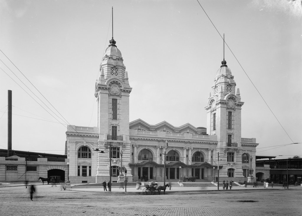
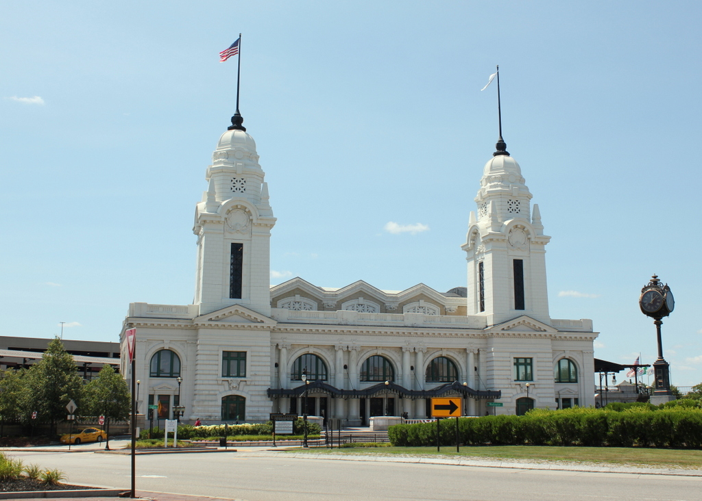
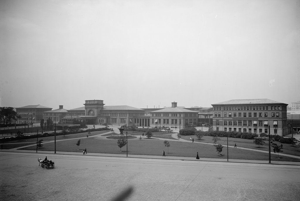
The view looking across City Hall Park toward Union Station in Providence, around 1906. Image courtesy of the Library of Congress, Detroit Publishing Company Collection.
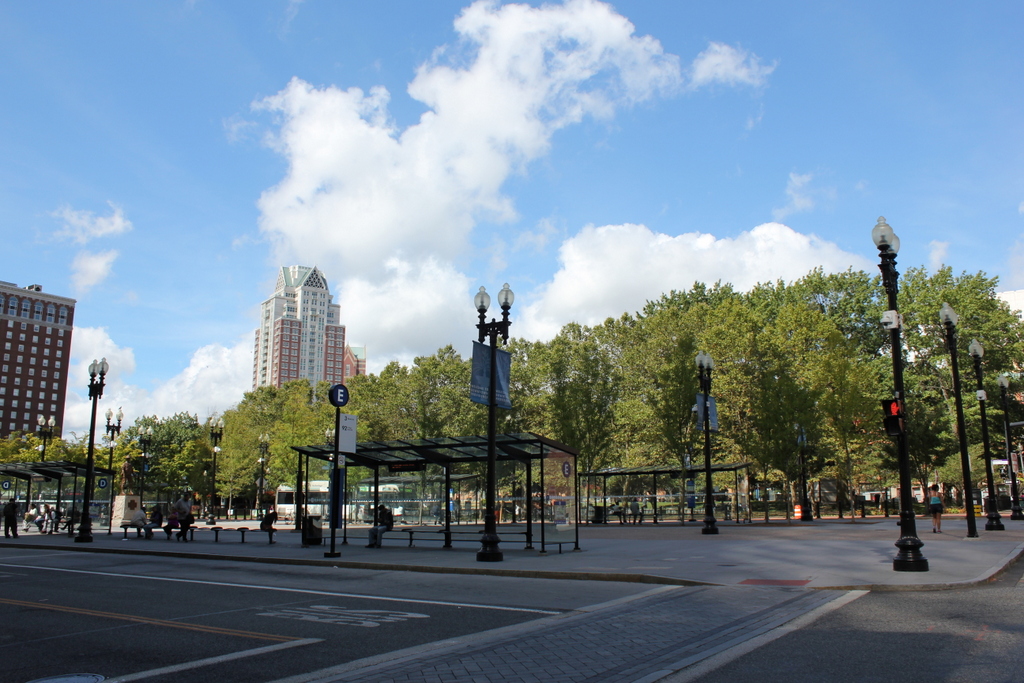
1069_1906c-loc
The view in 2016:

1069_2016
Both the park and the railroad station were relatively new features in downtown Providence when the first photo was taken. They were a part of the larger redevelopment plan of the late 19th century, which included the filling of the Cove basin and the construction of the new State House on Smith Hill. City Hall Park, located on the north side of Exchange Place, was dedicated in 1892 and landscaped in 1898, the same year that Union Station opened on the far side.

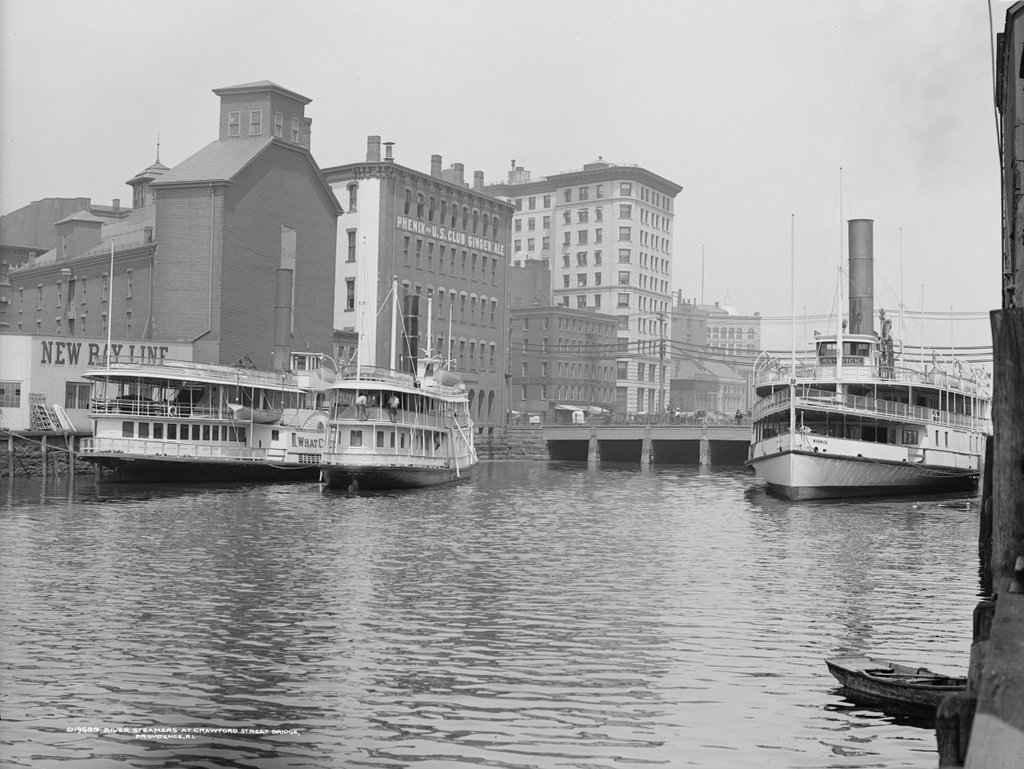
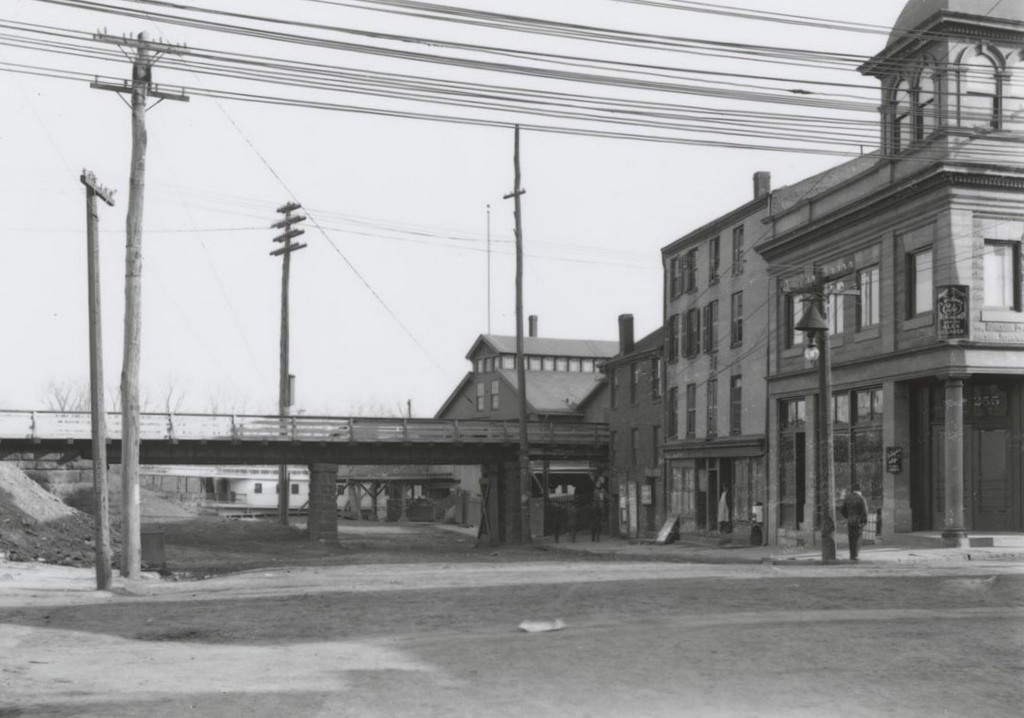
The station complex, as seen in the first photo, consisted of five buildings, and replaced an earlier station that had been damaged in an 1896 fire. Together with the new park and the nearby State House, the station provided a grand entrance for visitors to Providence. At a time when most inter-city travel was by rail, the railroad station was the first part of the city that most travelers saw. A good first impression was important, and with this new development, Providence had a station that was worthy of its status as an prominent, growing city.

As with other grand urban passenger stations of the late 19th and early 20th centuries, though, the Union Station saw a period of decline by the 1950s. The easternmost building, seen on the far right of the first photo, burned down in 1941, and in the postwar era there was a sharp drop in rail travel with the advent of commercial airlines and interstate highways.

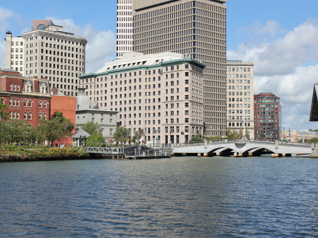
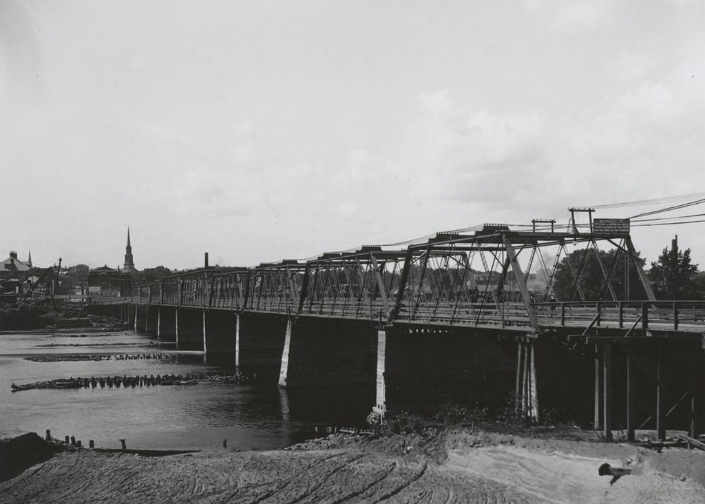
The building was badly neglected, and in 1986 it was rendered entirely obsolete. That year, the elevated tracks adjacent to the station were removed, and the railroad was rerouted a little further to the north. A new, smaller station opened just south of the State House, and the old station was left isolated, several blocks away from the tracks. The following year, it was badly damaged in a fire, but it was ultimately repaired. Even the destroyed easternmost building has since been rebuilt, and today the buildings have been restored and repurposed. From this view, the buildings are no longer visible because of the tall trees on the park, which is now known as Burnside Park. However, they are still there on the other side of the park, and they are listed on the National Register of Historic Places.

Providence River, Providence, RI

Looking upstream on the Providence River, with downtown Providence in the background, around 1906. Image courtesy of the Library of Congress, Detroit Publishing Company Collection.

1062_1906c-loc

The river in 2016:

1062_2016
This view is just downstream of the one in the previous post, and shows some of the same features, including the 1896 Banigan Building and the Crawford Street Bridge. At the time, the bridge was the head of navigation for the Providence River, so the first photo shows several steamboats docked here. These boats were a common sight at the turn of the 20th century, providing excursion trips to vacation destinations such as Newport, Block Island, and other destinations in Narragansett Bay, Long Island, and beyond.

Two of the three steamers in the first photo are identifiable. The one on the right is the Warwick, which had been built in 1873 and was in service for nearly 50 years until 1920. En route to Newport in January, the old boat sprung a leak, and later sank at its dock in Newport. Likewise, the What Cheer on the far left of the first photo also fell victim to old age around the same time. Built in New Jersey in 1867, the What Cheer operated in Narragansett Bay for many years before being sold to a New York company. Two years later, the old sidewheel steamer sank at the pier at Glen Island, and was deemed to be beyond repair.

Today, very little is left from the first photo. The only readily identifiable building in both photos is the Banigan Building, although the Customshouse, seen just to the left of it in the 2016 scene, would have also been standing in the first photo. Otherwise, not much remains. The industrial buildings to the left are gone, including the one with the lettering that reads “Phenix and US Club Ginger Ale.” There are no longer any coastal steamers on the river, although, as mentioned in the previous post, the river itself has seen great improvement. In the first photo, most of it in the distance was hidden under the Crawford Street Bridge, which was probably just as well at the time, considering how polluted it was with sewage and industrial waste. Today, the nearly quarter-mile wide bridge is gone, the river is cleaner, and it is now an integral part of downtown Providence’s cityscape.

Old Union Station, Worcester, Mass

Worcester’s old Union Station, seen around 1906. Image courtesy of the Library of Congress, Detroit Publishing Company Collection.

1030_1906c-loc

The scene in 2016:

1030_2016
This building was Worcester’s original Union Station, serving the Boston & Albany Railroad along with several other railroads. It was completed in 1875 in a Gothic Revival style designed by the Boston architectural firm of Ware & Van Brunt. Along with the usual passenger station amenities, it included a train shed over the tracks, along with a 212-foot clock tower at the corner of the building.

The station served Worcester for over 35 years, but by the early 20th century the city’s busy railroad traffic made it necessary to elevate the tracks through downtown. This, in turn, required a new station, which opened in 1911 just west of here. Most of the old station was demolished at this point, but the tower itself was saved. Unlike the two towers of the new station, which had to be taken down just 15 years later because of their deteriorated condition, the old 1875 tower stood here until 1959, when it was demolished to build Interstate 290.

Today, the 1911 Union Station, with replica towers, is still standing just to the right of the rotary, and in the distance the highway passes over the spot where the original station once stood. The only remnant from the first photo is the railroad itself, which can be seen on the right side of the photo, with MBTA commuter rail passenger cars passing over the bridge in the distance.

Union Station, Worcester, Mass

The Union Station in Worcester, around 1911-1920. Image courtesy of the Library of Congress, Detroit Publishing Company Collection.

1025_1910-1920-loc

Union Station in 2016:

1025_2016
Although Worcester’s Union Station looks largely the same now as it did over a century ago, the building has undergone dramatic changes in between. It was built in 1911, when the railroad tracks through downtown Worcester were raised above street level, requiring the replacement of the original 1875 Union Station, located just east of here. Although owned by the New York Central Railroad through their Boston & Albany subsidiary, the station served all of the railroads in Worcester, including the Providence & Worcester and the Boston & Maine. This new building was designed by the firm of Watson & Huckel, and its Beaux Arts architecture was very different from the Romanesque style of its predecessor, reflecting a major shift in architectural tastes from the late 19th to the early 20th centuries.

Although the twin towers of the building were its most iconic feature, the original ones lasted barely 15 years, and had to be removed in 1926 because of damaged caused by vibration from passing trains. The station, without the towers, remained in use for nearly 50 years, but by the mid-20th century passenger rail travel was in decline, and in 1972 it finally closed.

For more than 35 years, the station sat abandoned and decaying. Over time, the panes of glass in the skylight above the main concourse fell out, and for many years the interior was completely exposed to the elements. However, through decades of neglect the exterior remained structurally sound, and after several years of restoration work, the station reopened in 2000, complete with replicas of the towers that had been missing for nearly 75 years. Today, the restored building is a prominent Worcester landmark on the National Register of Historic Places, and from this angle is virtually indistinguishable from its original appearance.

State Street from Commerce Street, Hartford, Connecticut

Looking east on State Street toward the Connecticut River, from the corner of Commerce Street, on November 19, 1905. Image courtesy of the Connecticut State Library.

Section of State St. from Commerce St. (East)

The scene in 2016:

996_2016
It was hard to pinpoint the exact location of this photo, because Interstate 91 has completely obliterated the old street layout along the Connecticut River. The highway now runs directly through the 1905 scene here, but the present-day photo was taken from the plaza above the highway. So, it is the same spot as the first photo, just elevated probably about 20-30 feet.

Today, State Street extends across the Founders Bridge into East Hartford, and is a major thoroughfare in and out of the city. However, at the turn of the last century it ended here at the river, in much more humble surroundings than the busy commercial center just a few block away at the other end of the street. In the foreground is a bridge for the railroad tracks that ran along the Connecticut River, and just beyond it, in the center of the photo, was a warehouse for the Hartford & New York Transportation Company, a steamboat line that operated on the river. One of the boats is partially visible in the distance at the foot of State Street, at the city’s steamboat landing.

Steamboats have long since disappeared from the Connecticut River, along with all of the buildings here. Some were probably damaged or destroyed in the major floods of the 1930s, but any that did survive would have been gone by the 1960s, when I-91 was built through here. Today, this plaza above the highway provides riverfront access for pedestrians, and also connects to the walkway on the Founders Bridge. The only surviving remnant from the first photo is the railroad, which is still active but now mostly hidden beneath the highway.

Temporary Bridge, Hartford, Connecticut

The bridge across the Connecticut River at Hartford, seen from the East Hartford side on September 9, 1903. Image courtesy of the Connecticut State Library.

Temporary bridge, East Hartford end

The scene in 2016:

988_2016
For many years, the only bridge across the Connecticut River at Hartford was here at the site of the Bulkeley Bridge. In 1818, a covered bridge was built here, and it survived until May 17, 1895, when it was destroyed in a fire. With no other crossings available, a makeshift bridge was quickly built upstream of the ruins, opening just three weeks later. Before the end of the year it was washed away, but was replaced with the temporary bridge that is seen in the first photo.

As inconvenient as the loss of the old covered bridge may have been, it allowed Hartford the opportunity to build an elegant new bridge that reflected the city’s prosperity and importance. When the first photo was taken, work had already begun on building the Bulkeley Bridge and reconstructing Morgan Street on the Hartford side of the bridge. The temporary bridge was demolished after the new one was completed in 1908. The bridge has since been joined by two others in Hartford, but it still plays an important role in the city’s transportation, carrying Interstate 84 and US Routes 6 and 44. At over 100 years old, it is possibly the oldest bridge in the Interstate Highway System, predating the actual establishment of the highway system by nearly 50 years.