Morgan Street, Hartford, Connecticut

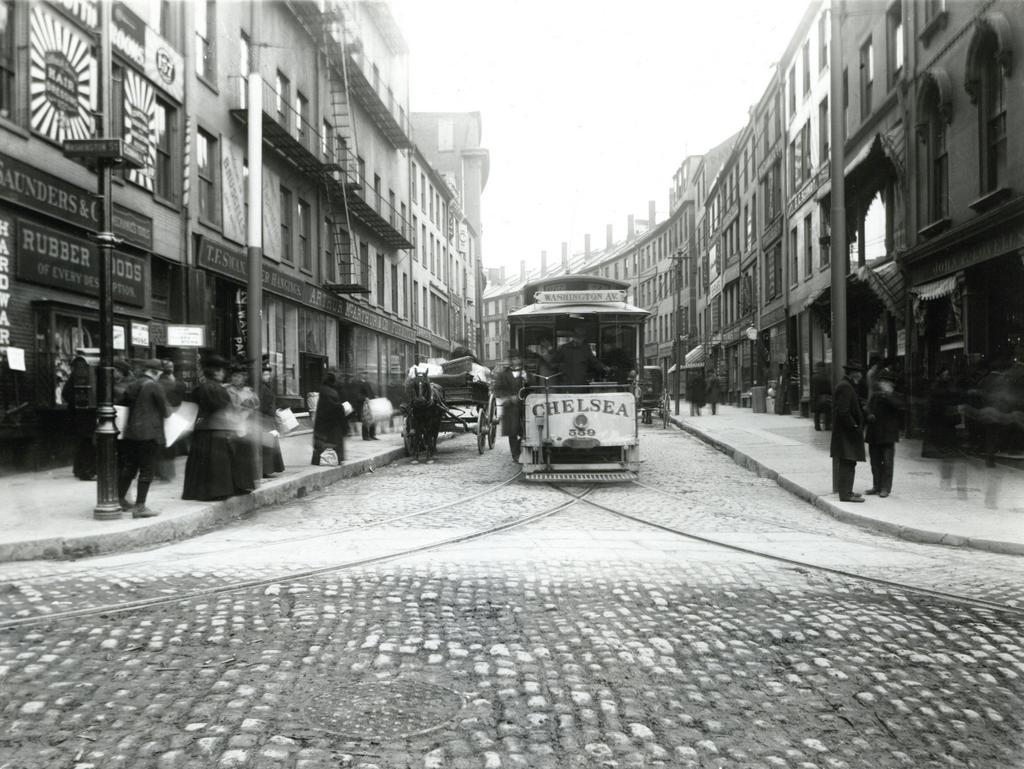
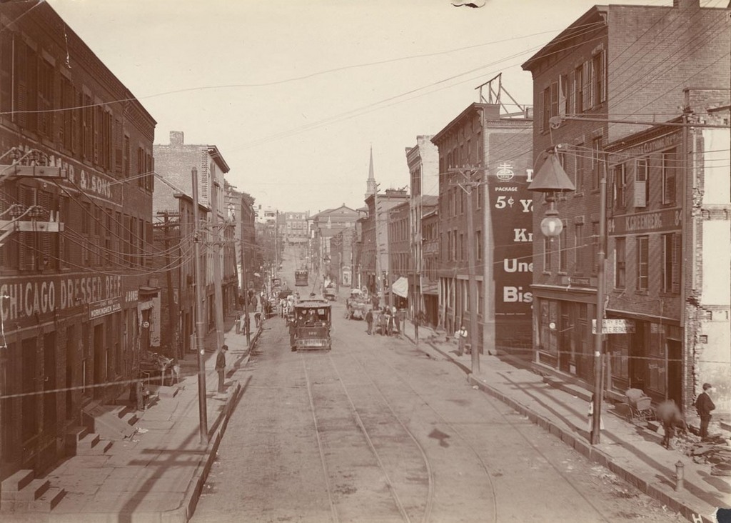
Looking west on Morgan Street from near the corner of Front Street (today’s Columbus Boulevard), on August 21, 1903. Image courtesy of the Connecticut State Library.

Morgan St. looking east

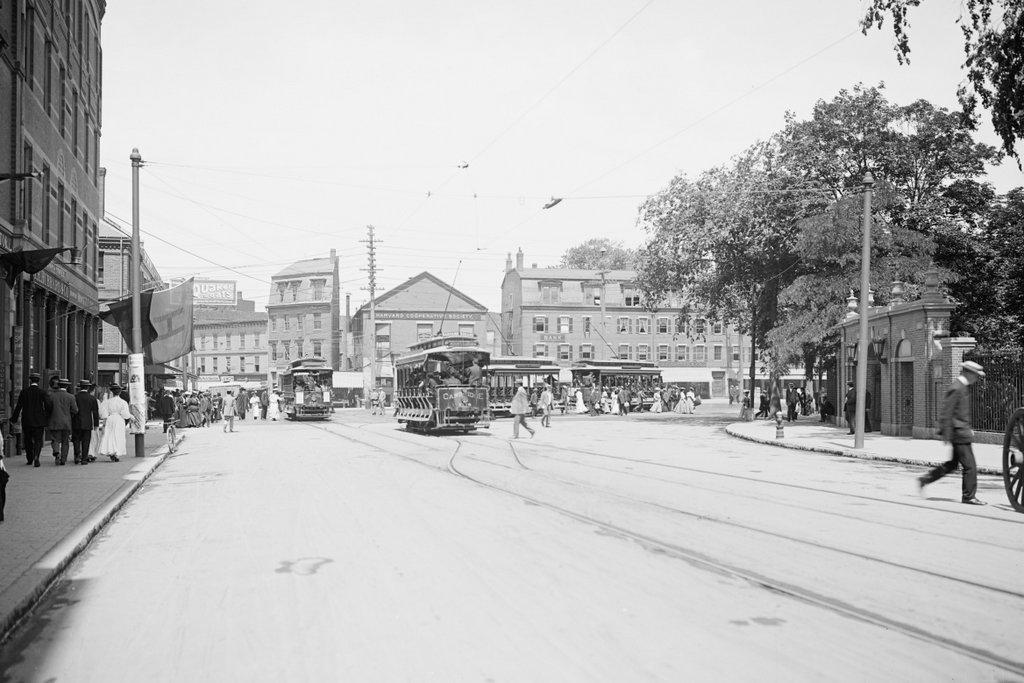
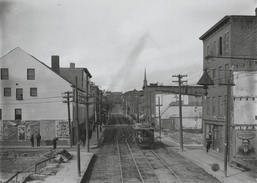
The view just two months later, on October 25, 1903. Image courtesy of the Connecticut State Library.
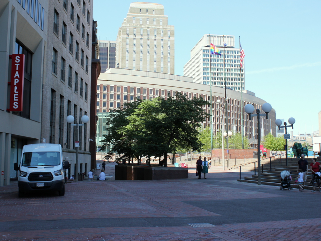
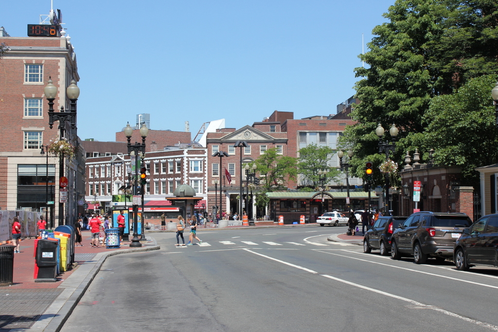
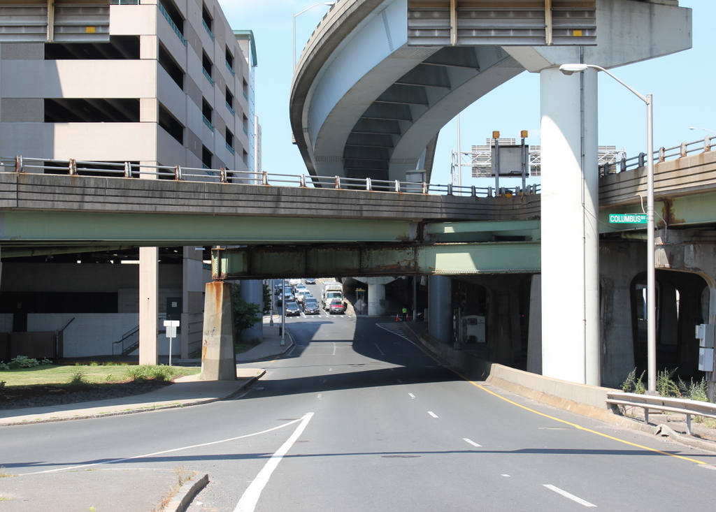
Morgan St., west of railroad bridge

The scene in 2016:

987_2016
For many years, the only bridge across the Connecticut River at Hartford was here at the foot of Morgan Road, just behind the photographer. The original covered bridge that had been built here in 1818 burned down in 1895, and although a temporary replacement was soon built here, a more permanent bridge was in the works. The city ultimately chose a stone arch bridge, which was completed in 1908 and is still standing as the Bulkeley Bridge. As part of the project, they designed broad avenues on either side of the bridge, which required demolition along Morgan Street.

As seen in the first two photos, Morgan Street was fairly narrow, and passed through the working-class neighborhood on the east side of the city. Looking to improve this and provide a more impressive entryway into the city, they demolished the buildings on both sides of the street to widen it. Although taken only two months apart, the first two photos here show the demolition progress, with at least five of the buildings gone by the time the second photo was taken. The buildings that were still standing were covered in advertisements, including the one on the far left that has posters for plays entitled “The Christian” and “A Working Girl’s Wrongs.”

In later years, further transportation improvements would reshape Morgan Street again. With the coming of the Interstate Highway System, this spot just west of the Bulkeley Bridge became the intersection of I-91, Connecticut’s primary north-south route, and I-84, one of the main east-west routes in the state. Any of the early 20th century efforts to make Morgan Street a grand boulevard were completely undone by the 1970s, when I-84 was built directly above the street. Today, instead of being lined with the tenement houses and merchant storefronts that once stood here, the street is now surrounded by parking garages and elevated highways.

Cornhill from Washington Street, Boston

Looking up Cornhill from Washington Street, on April 14, 1897. Image courtesy of the City of Boston Archives.

964_1897-04-14 coba

The scene in 2016:

964_2016
This narrow cobblestone street in downtown Boston connected Adams Square with nearby Scollay Square, and it was once a major literary center of the city, with many bookstores and publishers. When the first photo was taken, the early 19th century buildings here had a variety of businesses, with signs advertising for carpets, furniture, wallpaper, signs, trunks, and rubber goods. The first photo also shows a trolley coming down the street from Scollay Square, but this would soon change with the opening of the Tremont Street Subway in less than five months. Part of it was built under Cornhill, and it was the nation’s first subway, allowing trolleys to avoid the congested streets between Boston Common and North Station.

Nearly all of the buildings in the first photo were demolished in the early 1960s to build the Government Center complex. City Hall is just out of view on the right side of the 2016 photo, and the only building left standing in this scene is the Sears’ Crescent, partially visible in the distance on the left side of the street in both photos. Built in 1816 and renovated around 1860, this building still follows the original curve of Cornhill, serving as a reminder of what the neighborhood looked like before one of Boston’s most controversial urban renewal projects.

Harvard Square, Cambridge, Mass

Looking west toward Harvard Square on Massachusetts Avenue in Cambridge, around 1906. Image courtesy of the Library of Congress, Detroit Publishing Company Collection.

962_1906c loc

Harvard Square in 2016:

962_2016
The first photo was taken only a few years before the Red Line opened. At the time, people traveling from Cambridge to Boston had to use the streetcars, as shown here. In the distance on the left side of the photo, passengers are boarding a trolley whose destination is “Subway Park Street,” and the trolley to the right of it is presumably heading outbound from Park Street, on the way to its destination at Mount Auburn. This route was replaced in 1912 by the much faster Red Line subway, which originally ran from Park Street to here at Harvard Square, and a station entrance was built in the middle of the square. The station also included a streetcar tunnel that allowed passengers to easily transfer between the subway and the trolleys; this tunnel was later modified for buses and is still in use as the Harvard Bus Tunnel.

As for the buildings at Harvard Square, very little is left from the turn of the century. None of the buildings in the first photo have survived, with most being demolished in the early 20th century to build the current Colonial Revival buildings. Most of the businesses themselves are long gone, except for the Harvard Cooperative Society. Originally located in the Greek Revival-style building in the center of the photo, this bookstore was founded in 1882 as a cooperative for Harvard students. Now commonly known as The Coop, the bookstore is still in operation in a different building on the same spot, and serves students at both Harvard and MIT. Otherwise, the only landmark remaining from the first photo is the gate on the far right side, which connects the square to Harvard Yard.

Grand Central Terminal Whispering Gallery, New York City

The whispering gallery at the bottom of the ramp to the lower concourse at Grand Central Terminal, around 1913-1920. Image courtesy of the Library of Congress, Detroit Publishing Company Collection.

939_1913-1920 loc

The scene in 2016:

939_2016
These photos were taken from the bottom of the ramp that is seen in an earlier post, which leads from the Main Concourse to the station’s lower concourse. Because of the curve of the ceiling here, two people can stand facing the walls on opposite corners and speak at a normal level. The acoustics of the ceiling will carry their voices across the arch and the other person will be able to hear them perfectly clearly. That is, in fact, exactly what the person on the far right of the 2016 photo is doing; his friend was standing just out of the frame of the photo on the left side. I don’t know whether it was deliberately designed like that, or if the man in the bowler derby and overcoat in the first photo ever tried it out, but it is one of Grand Central Terminal’s more unusual architectural features.

Grand Central Terminal Suburban Concourse, New York City (2)

Another view of the lower concourse at Grand Central Terminal, around 1913-1920. Image courtesy of the Library of Congress, Detroit Publishing Company Collection.

938_1913-1920 loc

The scene in 2016:

938_2016
Like the photos in the previous post, this view shows the lower concourse at Grand Central Terminal. It is located directly underneath the Main Concourse, and when the station opened in 1913, this level was used for suburban commuter trains. The row of windows on the right side in the first photo were the ticket offices of the New York Central and Hudson River Railroad, which provided commuter service to the north of the city, along the present-day Hudson and Harlem Lines on the Metro-North Railroad. The ramp in the center of the photo is the same one that appears in the first photo, and it leads up to the Main Concourse. Beyond it are more ticket windows, for the New York, New Haven & Hartford Railroad, which provided service along the current Metro-North New Haven Line.

Today, this concourse is still used by commuters to access the trains on the lower tracks, but it also doubles as the station’s food court. Several prominent New York City restaurants have locations here, including Junior’s in the foreground and Shake Shack beyond it. Most of the original features are still here, including the marble walls, decorative ceiling, information kiosk to the left, and the ticket windows to the right, which now display menus.

Grand Central Terminal Suburban Concourse, New York City

The lower concourse at Grand Central Terminal, showing the ramp to the upper level, around 1913-1920. Image courtesy of the Library of Congress, Detroit Publishing Company Collection.

937_1913-1920 loc

The scene in 2016:

937_2016
Grand Central Terminal is best known for its spacious Main Concourse, but when the station first opened in 1913 the upper level was only used for inter-city trains. Commuters to the outer suburbs departed from this significantly less breathtaking concourse located on the lower level, directly underneath the Main Concourse. The first photo was probably taken around the time that the station opened, but over the years its function has changed. As explained in the previous post, the station is no longer split between long-distance and suburban trains; instead, Amtrak uses nearby Penn Station along with the Long Island Railroad and New Jersey Transit commuter lines, while Grand Central is exclusively a commuter rail station, used by the Metro-North Railroad.

Today, the lower concourse is significantly more crowded today than it was in the first photo. The lower tracks are still in use, but the concourse has taken on a second role as the station’s food court, with Shake Shack and other restaurants occupying the space on the left side where the ticket office windows were located in the first photo. Despite this, though, the underlying architecture has not changed much, and the station would still be recognizable to a commuter from the early 20th century.