Harpers Ferry, West Virginia (2)

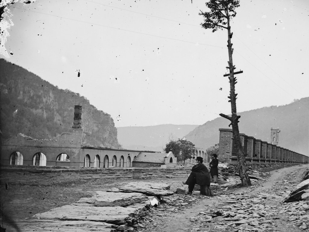
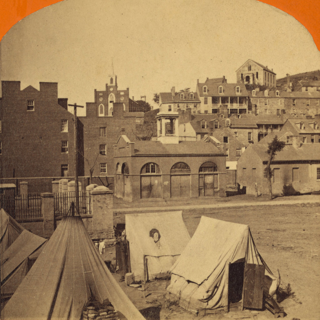
The town of Harpers Ferry, photographed around 1862. Image courtesy of the Library of Congress, Civil War Collection.
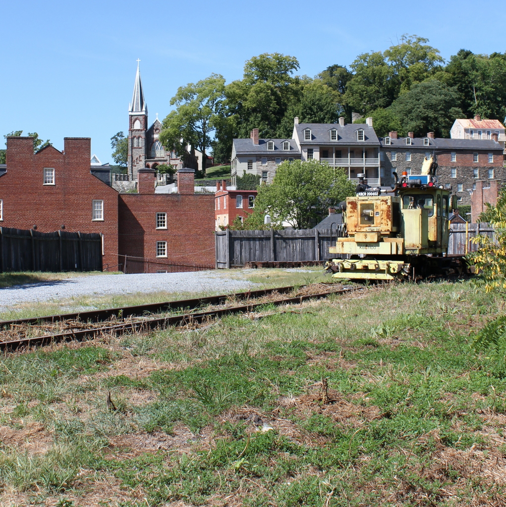
731_1860c loc

The view in 2015:

731_2015 loc
These two views of Harpers Ferry are remarkably similar, considering how much damage the small town sustained during the Civil War.  The Library of Congress estimates that this photo was taken around 1860, which seems a little too early.  This photo is half of a stereocard from a series called “War Views,” and since the war didn’t start until 1861, it seems unlikely that it was taken before then.  Instead, it was probably taken around 1862; the tents in the foreground were part of a “contraband camp” that the Union army established on the grounds of the former armory in March 1862 to house escaped slaves from the Confederacy.

A number of notable buildings are visible here, with the most prominent being the Armory fire engine house, better known as “John Brown’s Fort,” seen in the center of the photo and explained in more detail in this post.  To the left of the “fort” is the Gerard Bond Wager Building, a three and a half story brick building that was completed in 1838.  Prior to the Civil War it was used as a grocery and dry goods store, and it is still standing today and is operated by the National Park Service as a museum.

Beyond the Gerard Bond Wager Building is St. Peter’s Roman Catholic Church, which was built in 1833 and is still standing today, although with some extensive alterations.  It survived the Civil War, but it was renovated in 1896 to bring its exterior in line with the then-popular Neo-Gothic architectural style.  The original brick walls were replaced with granite, the steeple was removed, and a new asymmetrical facade was built with a taller steeple on the left side.

Another church in the original scene was St. John’s Episcopal Church, seen on the top of the hill to the right.  It was built in 1852 and sustained damage during the war, eventually being repaired in 1882.  However, it was subsequently abandoned in 1896, and today the picturesque ruins are still there, although they are hidden from view by the trees in the 2015 photo.

The last of the prominent historic buildings in these two photos are the four in a row next to each other, seen just below St. John’s Episcopal Church.  All four are still standing today, and the left-most of these is the Harper House, which is the oldest surviving building in the lower town.  It was completed in 1782 by Robert Harper, the town founder who not coincidentally operated a ferry here.  He died the same year it was completed, and it was later used as a tavern, a private residence, and by the start of the Civil War as a tenement house, accommodating up to four families.  To the right of the Harper House is Marmion Hall, which was completed in 1833, and the last two buildings to the right were built in the 1840s as the Marmion Tenant Houses.  These last two were, prior to the war, rented out to armory workers, who were just a short downhill walk away from their jobs.

Today, railroad tracks cover much of the former armory site, and nearly all traces of the historic site are long gone.  However, the town that grew up here because of the armory is, for the most part, preserved in its pre-1860s appearance.  Much of the lower town is now part of the Harpers Ferry National Historical Park, and is run by the National Park Service.

Armory at Harpers Ferry, West Virginia

The ruins of the Harpers Ferry Armory, photographed in October 1862. Image courtesy of the Library of Congress, Civil War Collection.

730_1862-10 loc

The scene in 2015:

730_2015 loc
Prior to the Civil War, Harpers Ferry was the location of one of the country’s two federal armories, with the other being in Springfield, Massachusetts.  Both sites were chosen by George Washington, and they had similar advantages.  Harpers Ferry and Springfield are both located on major rivers at the intersection of major transportation routes, but they are also located above the head of navigation on their respective rivers, preventing a naval attack from a foreign enemy.

In the first half of the 19th century, these two armories developed new ways to manufacture firearms, using machinery that mass-produced identical, interchangeable parts and that could be operated by unskilled workers.  By the start of the Civil War, there were over 15,000 guns stored here, which helped entice John Brown to lead a raiding party in 1859.  His goal was to start a slave rebellion by taking the arsenal and distributing the weapons to area slaves, and although the plan failed, it helped to spark the Civil War only a year and a half later.

By the time the first photo had been taken in October 1862, Harpers Ferry had already changed hands a number of times in the Civil War, and armies on both sides had steadily destroyed the buildings in order to prevent the other side from making use of them.  The ruins seen here are from the same building that can be seen on the right hand side of the 1861 photo in this post.

Around the time that the first photo was taken, the ruins had several notable visitors, including Abraham Lincoln, who toured the armory site in October, perhaps on the same day that the photo was taken.  Author Nathaniel Hawthorne also visited Harpers Ferry earlier in 1862, and wrote the following description in his essay “Chiefly About War Matters”:

Immediately on the shore of the Potomac, and extending back towards the town, lay the dismal ruins of the United States arsenal and armory, consisting of piles of broken bricks and a waste of shapeless demolition, amid which we saw gun-barrels in heaps of hundreds together. They were the relics of conflagration, bent with the heat of fire, and rusted with the wintry rain to which they had since been exposed. The brightest sunshine could not have made the scene cheerful, nor have taken away from the gloom from the dilapidated town; for, besides the natural shabbiness, and decayed, unthrifty look of a Virginian village, it has an inexpressible forlorness resulting from the devastations of war and its occupation by both armies alternately.

The town became part of West Virginia in 1863, and things were relatively stable here until the end of the war.  However, at that point the damage had been done.  The pre-war economy of Harpers Ferry had relied almost exclusively on the armory, but it was never rebuilt following the war.  The land was sold, and the Baltimore & Ohio built railroad tracks through part of the land, including the present-day railroad station, which was completed in 1889. Today, this area is part of the Harpers Ferry National Historical Park, and although there are no buildings still standing here from the armory, the interpretive signs help to give visitors an idea of what was once here.

Harpers Ferry, West Virginia

Looking across the Potomac River towards Harpers Ferry from the Maryland side of the river, around June 14, 1861. Image courtesy of the Library of Congress, Civil War Collection.

728_1861 loc

The same view in 2015:

728_2015 loc
The town of Harpers Ferry had only about 1,300 residents at the start of the Civil War, and its land area was just a half a square mile, but it became among the most contested places of the war.  It was literally located on the border of the Union and the Confederacy, changing hands eight times during the war and ending up in a different state by the time it was over.

As its name implies, this area was first settled as a ferry crossing.  Originally part of Virginia, it is located at the confluence of the Potomac and Shenandoah Rivers, and beginning in 1733 colonist Peter Stevens operated a ferry across the Potomac here, enabling settlers from Maryland and Pennsylvania to access the Shenandoah Valley of Virginia.  The town isn’t named Stevens Ferry, though, because around 1748 he sold his land and ferry to Robert Harper, who operated it until his death in 1782.

Because of its transportation connections and relatively defensible position, Harpers Ferry was one of two locations, along with Springfield, Massachusetts, selected by George Washington for federal armories.  Further transportation developments came in the 1830s: the Chesapeake & Ohio Canal (seen in the lower foreground of both photos) was completed as far as Harpers Ferry in 1833, several stagecoach lines were opened in 1834, and the Baltimore & Ohio Railroad reached the Maryland (foreground) side of the river later in 1834.  The first railroad bridge was completed in 1837, allowing a direct connection from the armory to the rapidly growing national rail network.

By 1850, this small town had grown to over 1,700 people thanks to the armory (visible along the waterfront to the right in the first photo), but before the end of the decade it would become the center of one of the major precursors to the Civil War.  In October 1859, abolitionist John Brown led a raiding party of 22 men in an attempt to capture the arsenal and start a slave rebellion.  The raid ultimately failed, and most of the raiders were either killed or were captured and executed, including John Brown, whose December 2 execution was seen as a martyrdom by many northern abolitionists.

The Civil War began just a year and a half after the raid, and Virginia’s state legislators voted to secede on April 17, 1861.  One of the state’s first objectives was to take the Harpers Ferry arsenal, which at the time was guarded by just 65 men.  Led by Lieutenant Roger Jones, they destroyed the arsenal and its 15,000 guns before evacuating the town ahead of the Confederates.  The Confederates didn’t occupy the town for long, though.  They left on June 14, and burned the Baltimore & Ohio bridge as they left.  The remains of the bridge can be seen in the foreground of the first photo, which according to the caption was “photographed immediately after its evacuation by the rebels.”

When the first photo was taken, the town was still relatively intact, but as the war progressed it became somewhat of a no man’s land.  Despite the loss of the armory, it was still a vital transportation corridor for armies on both sides, so between 1861 and 1863 it changed hands several more times.  West Virginia became a state on June 20, 1863, with Harpers Ferry citizens voting 196 to 1 to leave Virginia and join the union.  The town was briefly occupied by the Confederates in early July, but they soon evacuated for the last time and Union solders returned on July 13, finally bringing stability to Harpers Ferry for the rest of the war.

In terms of population, Harpers Ferry never fully recovered from the Civil War.  The armory never reopened, and the population has steadily fallen to less than 300 as of the 2015 census.  However, it has become a major tourist destination, with the Harpers Ferry National Historic Park now comprising much of the historic town.  Although the Chesapeake & Ohio Canal has not operated in nearly a century, there are still several railroad lines that pass through here.

One of the bridges, seen to the right in the 2015 photo, also carries the Appalachian Trail over the Potomac River on a pedestrian walkway on the left side of the bridge.  The bridge pier in the foreground is from an earlier railroad bridge that had been built on the spot of the one that was destroyed in 1861.  This bridge, in turn, was washed away in a 1936 flood, and it was never rebuilt.  Today, the modern railroad bridge, as well as trees along the river, help to hide the view of Harpers Ferry, with only a few buildings visible in the 2015 scene.

(Much of the information for this post came from “To Preserve the Evidences of a Noble Past”: An Administrative History of Harpers Ferry National Historical Park (2004).  For further reading, it and other resources are available online here at the National Park Service website.)

Old City Hall, Boston

Johnson Hall, which served as a courthouse and later as City Hall, on School Street around 1855-1862. Image courtesy of the Boston Public Library.

691_1855-1862c bpl

Boston’s old City Hall, which replaced Johnson Hall, as seen in 1865. Image courtesy of the Boston Public Library.

691_1865 bpl

Old City Hall in 2015:

691_2015
This site on School Street has had two different City Hall buildings, as seen in the photos above, but the history here goes back even further.  From 1704 to 1748, Boston Latin School was located here, and during this time many of the Founding Fathers attended the school, including Benjamin Franklin, John Hancock, Samuel Adams, and Robert Treat Paine.  Years later, Charles Bulfinch designed a courthouse that was built here in 1810; this building, which is shown in the first photo, was used as both a county and federal courthouse in the early 19th century.  From 1841 until 1862, it was Boston’s City Hall, before being demolished and replaced with a newer, larger building.

The new City Hall was completed in 1865, and was one of the first examples of Second Empire architecture in the United States.  This French-inspired style would become very popular in the late 1860s and 1870s, especially in government buildings.  Boston’s old post office, which was built a decade later and just a few blocks away, shares many similar features.  On a much larger scale, the Old Executive Building next to the White House in Washington, DC also reflects the influence of Second Empire designs.

During its time as City Hall, this building saw the rapid growth in the city during the late 1800s and early 1900s.  When it was completed, the city had fewer than 200,000 people, but by the 1950s there were over 800,000, and the city government had long since outgrown this building.  The City Hall Annex, located behind this building on Court Street, was built in 1912 to accommodate more offices, but by the 1960s the city was looking to build a new City Hall.  The current building was completed in 1968, and since then the old building has been extensively renovated on the inside for commercial uses, but the exterior is essentially unchanged from 150 years ago.

Pemigewasset House, Plymouth, NH (1)

The Pemigewasset House in Plymouth in 1860. Image from History of Plymouth, New Hampshire (1906).

599_1860 historyofplymouthnh

The rebuilt hotel, around 1908. Image courtesy of the Library of Congress, Detroit Publishing Company Collection.

599_1908c loc

The scene in 2015:

599_2015
The town of Plymouth is sort of the gateway to the White Mountains; it is located at the very southern end of the region, along the Pemigewasset River. This river valley forms the primary transportation corridor to the White Mountains from the south, and the town was a logical place to run an inn.  Beginning in the 1760s, Colonel David Webster operated a tavern here, which was subsequently expanded by his family in the early 1800s.  Wesbter’s Tavern was sold to Denison R. Burnam in 1841, who renamed it the Pemigewasset House, after the river that runs behind it.  By the time the 1860 photo was taken, Burnam had expanded the building several times, but two years later it was destroyed in a fire.

The Pemigewasset House was quickly rebuilt as the building seen in the second photo.  The hotel came under the ownership of the Boston, Concord, & Montreal Railroad, whose tracks were located on the opposite side of the building.  Around noon, both northbound and southbound trains would stop here for a half hour so passengers could eat in the dining room, and for those who wanted to stay the hotel could accommodate 300 guests at $3 per night or $14 to $17.50 a week.  For those heading further north to the White Mountains, they could either take the railroad or, if the Profile House at Franconia Notch was their destination, they could take a more direct trip on the daily stagecoach.  This 30 mile journey took all afternoon back in the late 1800s; today, a traveler can make the same trip on Interstate 93 in about a half hour.

The hotel is probably best known, however, as the place where Nathaniel Hawthorne died.  Hawthorne had been in poor health, so in the spring of 1864 he took a trip to the White Mountains with his friend, former president Franklin Pierce, in an attempt to recuperate.  The two had been friends since the 1820s, when they met at Bowdoin College.  By the time Pierce became a presidential candidate, Hawthorne had already become famous as the author of The Scarlet Letter, The House of Seven Gables, as well as a number of short stories (including “The Ambitious Guest,” written about a traveler who dies at a hotel in the White Mountains).  In 1852, Hawthorne used his fame and writing talent to write a glowing biography of Pierce, portraying him as a man who could unite north and south and preserve the country.  Later that year, Pierce was elected president in a landslide, and Hawthorne was rewarded with a consulate position in England.

By the time they took their trip together to the White Mountains 12 years later, though, things had changed; the country was in the middle of the Civil War, and many blamed Pierce and his disastrous presidency.  They must have made an interesting sight, with one of the most hated, disgraced public figures in the country traveling with one of the most popular and respected authors of the time.  One of their stops was in Dixville Notch, a small unincorporated village in the extreme northern part of New Hampshire, and from there they traveled 100 miles south to the Pemigewasset House, where they stayed on the night of May 18, 1864.  They had dinner and tea at the hotel in the evening, but next morning Pierce awoke to discover that Hawthorne had died in his sleep, at the age of 59.

Like its predecessor, and like countless other massive wood-framed hotels of its day, the Pemigewasset House was vulnerable to fire.  It burned down in early 1909, probably less than a year after the second photo was taken, and in 1913 a new hotel was built a little further up the hill.  It is also no longer standing, having been demolished in the 1950s.  Today, the site of the first and second buildings has been completely redeveloped, and it is difficult determining exactly where the hotel once stood.  However, maps from the 1800s indicate that it was located between Main Street and the railroad tracks, just south of Highland Street.  The 2015 scene was taken from Main Street, facing the triangular-shaped building on the south corner of Main Street and Railroad Square.

Old Grafton County Courthouse, Plymouth, NH

The Old Grafton County Courthouse on Court Street in Plymouth, around 1900-1910 during its use as a library. Image courtesy of the Library of Congress, Detroit Publishing Company Collection.

597_1900-1910 loc

The building in 2018:

Over the years, this building has served a variety of purposes in several different locations.  It was built in 1774 as one of two courthouses in Grafton County, and was located at the corner of Russell and Pleasant Streets, less than a quarter mile from where it is today.  During its time as a courthouse, 24 year old New Hampshire native Daniel Webster argued one of his first court cases here in 1806.  He lost, and his client was hanged, but he would nonetheless go on to be a successful lawyer and one of the country’s most powerful politicians of the pre-Civil War era.

While Webster’s career was just beginning, the old courthouse was becoming obsolete, and in 1823 it was replaced by a more substantial brick building.  The old building was moved south of the main village and used as a wheelwright shop, as seen in the photo below, which was taken in 1860 and published in History of Plymouth, New Hampshire (1906):

597_1860 ahistofplymouthnh same building different location
By the 1870s, the century-old building had been abandoned and was in disrepair, but its connection to Daniel Webster’s early career brought it to the attention of Henry W. Blair, a Congressman and future Senator who purchased it in 1876.  After moving it to its present location and renovating it, Blair gave the building to the Young Ladies’ Library Association to use as a public library.  The small building was home to Plymouth’s library until 1991, when the present-day Pease Public Library was built.  Since then, the historic building has been home to the Plymouth Historical Museum.