Randall and Second Streets, Adams, Mass (3)

Looking north on Second Street toward the corner of Randall Street in Adams, around 1900-1915. Image courtesy of the Library of Congress, Detroit Publishing Company Collection.

The scene in 2019:

These photos were taken from the same spot as the ones in the previous post, just facing further to the north. The original photos, including ones featured in blog posts here and here, may have actually been intended as a panorama, because they line up with just a bit of overlap; the duplex on the far left here is the same building on the far right in the previous post.

In any case, these historic photos were taken in the early 20th century, when Adams was a fast-growing factory town. Its population had doubled in the 20 years between 1880 and 1900, and this period saw the development of new residential neighborhood, including these streets on the hillside immediately to the east of the center of town. Some of the houses here had already been built by the time the first photo was taken, but there were sill many vacant lots, and the streets were simply narrow dirt paths.

As mentioned in the previous house, the 1900 census shows that the duplex on the left, at 40-42 Randall Street, was the home of two different families. On the left side was Fred Wilder, a teamster who lived here with his wife Ida, their daughter, and a boarder. The other side of the house was rented by Grace Welch, a 23-year-old woman who lived here with her three children.

Also during the 1900 census, the house in the center of the photo, at 44 Randall Street, was owned by Arthur Randall, whose family may have been the namesake of the street. He was 26 years old at the time, and he, like several of his neighbors, worked as a teamster. At the time, four generations of the family lived here, including Arthur and his wife Azilda, their infant son Everett, Arthur’s father Levi Randall, grandfather Gilbert Harrington, and niece Ella Randall. Levi, who was 58 years old in 1900, worked as a carpenter, and according to the 1904 county atlas he was the owner of the duplex at 40-42 Randall Street.

The other house visible in the first photo is at 14 Second Street, located beyond and to the right of the Randall house. In 1900 it was owned by 43-year-old Marcus Harrington, the uncle of Arthur Russell. He was a blacksmith, and he lived here with his wife Elizabeth and their three children: Walter, Velma, and Earl. According to the 1904 atlas, he also owned the neighboring house at 16 Second Street. However, this house does not appear on the census, so it may have been either unbuilt or vacant in 1900.

Today, more than a century after the first photo was taken, much has changed in this scene. The roads look very different, having been widened and paved, and the exteriors of the houses have also changed, including the removal of the shutters, installation of modern siding, and alterations to the front porches. Overall, though, the turn-of-the-century houses are still standing here, and this scene is still easily recognizable from the first photo.

Randall and Second Streets, Adams, Mass (2)

The view looking northwest from the corner of Randall and Second Streets in Adams, around 1900-1915. Image courtesy of the Library of Congress, Detroit Publishing Company Collection.

The scene in 2019:

These two photos were taken from the same spot as the ones in the previous two posts, which face to the southwest and west. This particular view looks toward the northwest, with the town of Adams in the foreground and the Greylock Range in the distance. The present-day photo does not line up perfectly with the first one, as the line of sight from the original spot is blocked by the house on the far left, but the two photos show the same overall scene, including the two houses on the right side of the first photo, which still stand here in the second photo.

The houses here in the foreground were, for the most part, built around the late 19th century. During this time, Adams was growing in population, becoming an important manufacturing center on the Hoosic River, and residential neighborhoods were steadily making their way up the hillside to the east of town. Many of the house lots were still undeveloped by the time the first photo was taken at the turn of the century, as indicated by the cornfield in the foreground, but most of these would soon have houses on them.

The two houses on the right side of the first photo were both built sometime around 1900, and they are both included in that year’s census. At the time, the one furthest to the right, at 40-42 Randall Street, was occupied by two families. The left side was the home of 34-year-old teamster Fred Wilder, his wife Ida, their daughter Bertha, and a boarder who also worked as a teamster. On the right side was 23-year-old Grace Welch, who lived here with her three children. They ranged in age from 10 months to 7 years, and according to the census she had been married for nine years. It also listed her as being a widow, although subsequent censuses show her as being married to Melvin Welch, so this part of her record was likely in error.

To the left of the duplex is a single-family home at 38 Randall Street. In 1900 it was owned by Ai Davis, a 47-year-old stonemason who lived here with his wife Nora and their five children, the oldest of whom was 23 and the youngest was 5. Their oldest, Hiram, was a teamster, and two other children were listed as attending school. Like her neighbor Grace, Nora had also apparently married very young, because she was 39 years old in 1900 and had already been married for 24 years.

Further in the distance, the most visible building in downtown Adams is the Berkshire Cotton Manufacturing Company. Founded in 1889, the company grew quickly over the next few decades, and by the time the first photo was taken in the early 20th century it consisted of a large factory complex with a number of buildings in the center of the scene. In 1904, the company had around 2,400 people, making it a significant employer in a town that, at the time, had around 12,000 residents.

In more than a century since the first photo was taken, many changes have occurred here in this scene. The cornfield in the foreground is gone, having been replaced by the house on the far left side at some point around the 1920s. In the distance, the slopes of Mount Greylock are now far more wooded than they had been in the first photo, and much of downtown Adams is also now obscured by trees. The houses at 38 and 40-42 Randall Street are still standing though, as are some of the buildings in the Berkshire Cotton Manufacturing Company complex.

During the 20th century, Berkshire Cotton Manufacturing went through a series of mergers in the 20th century, eventually merging with Hathaway Manufacturing in 1955 to become Berkshire Hathaway. It continued to produce textiles here into the second half of the 20th century, and came under the control of a young Warren Buffett in 1965. The factory ultimately closed, and many of the buildings have since been demolished, but the company itself still exists. No longer a small-town cotton mill, Berkshire Hathaway is now a major multi-national holding company headquartered in Omaha, although its name continues to serve as a reminder of its origins here along the Hoosic River in Adams.

Mount Greylock from Adams, Massachusetts

The view of Mount Greylock as seen from the corner of Randall and Second Streets in Adams, around 1900-1915. Image courtesy of the Library of Congress, Detroit Publishing Company Collection.

The scene in 2019:

These two images do not line up perfectly; the first one was taken a few yards to the south of where the 2019 one was taken. However, the view from that spot is now blocked by a house that stands where the cornfield in the foreground used to be, so the present-day photo was taken a little closer to the corner of Randall Street. However, the overall scene is the same in both photos, showing the town of Adams at the bottom of the hill, with the summit of Mount Greylock as the backdrop in the distant center.

Standing 3,491 feet above sea level, Mount Greylock is the highest point in Massachusetts. It is part of the Taconic Mountains, a range within the Appalachians that runs roughly along the New York-Massachusetts border, and it is also one of the most topographically-prominent mountains in New England, rising nearly 2,500 feet above all of its surrounding valleys. As a result, it is visible for miles in every direction, and it is the most distinctive landscape feature within the town of Adams.

The east slope of the mountain, shown here in this scene, is its steepest. From the summit, it drops more than 2,700 feet in less than three miles to the floor of the Hoosic River valley. The town of Adams was settled here along the river, and during the second half of the 19th century it developed into a thriving industrial community. The town was divided in half in 1878, with the more populous northern half becoming North Adams, but Adams continued to grow, and by the time the first photo was taken at the turn of the 20th century its population had risen to over 10,000 residents.

The photo shows the downtown area of Adams, as seen from the hills immediately to the east. By this point, this area was in the process of being developed for housing, and the 1904 county atlas shows that the land in the foreground had already been subdivided into individual lots. Some of the houses had already been built by then, but other lots were still vacant, including the cornfield here in the first photo. However, within a decade or two this site would also be developed, and there is now a 1920s-era house that stands just out of view on the left.

Today, Adams is no longer a major factory town, and its population is actually smaller than it was at the turn of the last century. Overall, though, this view is not significantly different from the first photo. Probably the single most noticeable change is the increased number of trees. In the foreground, downtown Adams is mostly hidden by the trees, although there are several buildings visible, most notably the First Congregational Church, which stands in the center of the scene. Beyond the town, the slopes of Mount Greylock are much more wooded today than in the first photo, and at the summit is the Veterans War Memorial Tower, which was dedicated in 1933 in memory of Massachusetts residents who died in World War I.

Randall and Second Streets, Adams, Mass

The view looking southwest from the corner of Randall and Second Streets in Adams, around 1900-1915. Image courtesy of the Library of Congress, Detroit Publishing Company Collection.

The scene in 2019:

During the late 19th and early 20th centuries, the Berkshires became an important industrial center, with a number of factories located along the Housatonic and Hoosic Rivers. Here in Adams, near the northwest corner of Massachusetts, the town saw rapid growth during this period because of its industries. It lost nearly two thirds of its population in 1878 when its northern half was partitioned off as the town of North Adams, but over the next 20 years it doubled in population, ultimately reaching its peak at just over 13,000 people by 1910.

The first photo was taken around this time, facing southwest from the hillside just to the east of the center of town. A portion of downtown Adams is visible in the distance, including the steeple of First Baptist Church, which stands in the center of the photo. Further beyond the town is the southern end of the Greylock Range, which features the tallest mountains in the state. The highest, Mount Greylock, is just out of view on the far right side, but the state’s second-highest peak, Saddle Ball Mountain, is evidently visible in this scene.

In the foreground of the first photo is a corn field. At the time, this neighborhood was only partially developed, consisting of a few late 19th century homes interspersed with empty lots such as this one. However, by this point the area was already eyed for future development, with the 1904 county atlas showing that this land had already been subdivided into new streets and house lots, which were owned by the Bonnie Brae Land Company. Many of the houses and streets were ultimately never built, perhaps because the population of Adams plateaued after 1910, but this former corn field was developed sometime after the first photo was taken. As shown in the present-day scene, it is now the site of a bungalow-style house that, based on its architecture, was probably built sometime around the 1920s.

Lenox Library, New York City

The Lenox Library, seen from the corner of Fifth Avenue and 70th Street in New York City, around 1900-1906. Image courtesy of the Library of Congress, Detroit Publishing Company Collection.
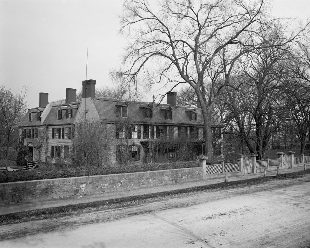
The scene on December 20, 1913. Image courtesy of the Library of Congress, George Grantham Bain Collection.

The scene in 2019:

The modern concept of a public library in the United States began in the second half of the 19th century, and many such libraries had their origins in private libraries that were run by organizations or by wealthy benefactors. Here in New York City, these included the Astor Library and Lenox Library. Both were open to the public—with restrictions, particularly here at the Lenox Library—but they were intended primarily for researchers, and the books did not circulate. However, these two libraries formed the basis for the New York Public Library, which was established upon their merger in 1895.

The Lenox Library was the younger of the two institutions, having been established in 1870, although its founder, James Lenox, had begun collecting rare books several decades earlier. The son of wealthy merchant Robert Lenox, James inherited over a million dollars after his father’s death in 1839, along with a significant amount of undeveloped farmland in what is now the Upper East Side. He had studied law at Columbia, although he never actually practiced, instead spending much of his time collecting books and art.

For many years Lenox kept his collection in his house, which became increasingly overcrowded and disorganized. As a result, he created the Lenox Library in 1870, and that year he hired architect Richard Morris Hunt to design a suitable building, which would be located on Lenox-owned land here on Fifth Avenue, opposite Central Park between 70th and 71st Streets. It was one of the first major commissions for Hunt, who would go on to become one of the leading American architects of the late 19th century.

The building, shown here in the first photo, was completed in 1877. It was a combination library and art museum, featuring four reading rooms plus a painting gallery and a sculpture gallery. Admission was free of charge, but for the first ten years patrons were required to obtain tickets in advance by writing to the library, which would then send the tickets by mail. In any case, the collections here at the library would not have been of much interest to the casual reader. Because of Lenox’s focus on rare books, the library was, in many ways, more of a museum of old books than a conventional library. In addition, its holdings were far less comprehensive than most libraries, with a narrow focus on the subjects that Lenox was personally interested in.

Despite these limitations, though, the library was valuable for researchers searching for hard-to-find volumes. Perhaps the single most important book in its collection was a Gutenberg Bible, which Lenox had acquired in 1847. It was the first Gutenberg Bible to come to the United States, and it is now owned by the New York Public Library, where it is on display in the McGraw Rotunda. Other rare works included Shakespeare’s First Folio and the Bay Psalm Book, which was the first book published in the American colonies. Aside from books, the library also had important documents, including the original manuscript of George Washington’s farewell address, and its art collection featured famous paintings such as Expulsion from the Garden of Eden by Thomas Cole, and a George Washington portrait by Gilbert Stuart.

Overall, James Lenox contributed about 30,000 books to the library, which continued to grow after his death in 1880. By the 1890s, it had over 80,000 books, thanks to a number of significant donations and purchases. These additions helped to broaden the scope of the collection, making it more useful to the general public. However, the library struggled financially during the late 19th century, as did the Astor Library, and in 1895 they merged with the newly-created Tilden Trust to form the New York Public Library.

The new library subsequently moved into its present-day location at Fifth Avenue and 42nd Street in 1911, and the former Lenox Library was sold to industrialist Henry Clay Frick, who demolished it to build his mansion on the site. A longtime business associate of Andrew Carnegie, Frick was the chairman of the Carnegie Steel Company, and by the 1910s he was among the richest men in the country. In 1918, for example, the first Forbes Rich List ranked him second only to John D. Rockefeller, with a net worth of around $225 million.

Frick had purchased the library property in 1906 for $2.47 million, but he had to wait until the library had moved its collections to the new building before he could take possession of the land. He ultimately acquired it in 1912, and demolished the old library that same year. His new home was then built here over the next two years, with a Beaux-Arts exterior that was designed by Thomas Hastings, a noted architect whose firm, Carrère and Hastings, had also designed the New York Public Library. The second photo shows the house in December 1913, in the midst of the construction. The exterior was largely finished by this point, but it would take nearly a year before Frick moved into the house with his wife Adelaide and their daughter Helen.

Like James Lenox, Frick was a collector, using his vast fortune to amass a variety of artwork and furniture. Upon his death in 1919, he stipulated that his house and its contents would become a museum, although Adelaide would be allowed to live here for the rest of her life. She died in 1931, and over the next four years the house was converted into a museum, opening to the public in 1935 as the Frick Collection.

Today, despite its changes in use, the exterior of the building from this view is not significantly different than it was when the first photo was taken more than a century ago. It still houses the Frick Collection, with the museum receiving around 300,000 visitors per year. Although not as large as many of the other major art museums in New York, it features a high-quality collection of paintings and furniture, including a good variety of works by the European Old Masters. The building itself is also an important work of art in its own right, and in 2008 it was designated as a National Historic Landmark in recognition of its architectural significance.

William Tecumseh Sherman Statue, New York City

The statue William Tecumseh Sherman at the present-day Grand Army Plaza in New York, around 1903-1906. Image courtesy of the Library of Congress, Detroit Publishing Company Collection.

The scene in 2019:

The first photo was taken sometime soon after the 1903 dedication of William Tecumseh Sherman, an equestrian statue honoring the famous Civil War general. Although a native of Ohio, Sherman spent his later years in New York City, and after his death in 1891 the New York Chamber of Commerce commissioned prominent sculptor Augustus Saint-Gaudens to design a memorial in his honor.

It took Saint-Gaudens more than a decade to complete the statue, and it was installed here at the corner of Fifth Avenue and West 59th Street, at the southeast corner of Central Park. This area is now known as Grand Army Plaza, although it did not receive this name until 1923. The statue features Sherman astride his horse Ontario, and they are being led by the winged goddess Victory, who wears a laurel crown and carries a palm frond in her left hand. The figures stand atop a pink granite base, which was designed by Charles Follen McKim, one of the leading American architects of the late 19th and early 20th centuries.

In 1913, the statue was moved 15 feet to the west of its original location, in order to place it in line with the newly-installed Pulitzer Fountain on the south side of the plaza. Then, a few years later, it was temporarily removed from this site and placed in storage, in order to make room for the construction of a new subway line. It was eventually returned here by the early 1920s, and over the years it has been re-gilded several times, most recently in 2013. At some point the statue also lost its palm frond and sword, but these were replaced during a late 1980s restoration, and today the statue looks essentially the same as it did when the first photo was taken more than a century ago.