Fort Gilbert Monument, West Brookfield, Mass

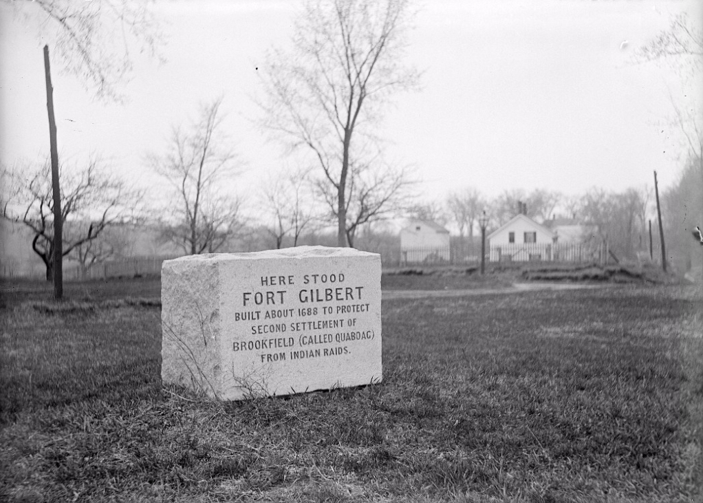
The Fort Gilbert Monument at the corner of North Main and Winter Streets in West Brookfield, around 1902-1927. Image courtesy of the Longmeadow Historical Society, Emerson Collection.

956_1902-1927 lhs

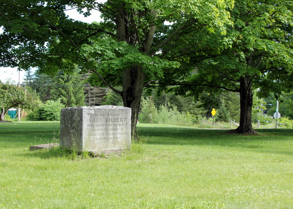
The monument in 2016:

956_2016
The town of Brookfield, which originally included present-day North, East, and West Brookfield, was first settled by Europeans in 1660 as the town of Quaboag. At the time, it was in a very isolated location in central Massachusetts, some 25 miles from the towns in the Connecticut River valley and twice as far from Boston and the other towns along the coast. Because of this, it was very vulnerable to an Indian attack, which occurred in 1675 during King Philip’s War. The town was destroyed and abandoned, with many of the settlers moving back to where they had previously lived.

Over a decade later, settlers returned, and this time they came better prepared for potential raids. They built four forts, including Fort Gilbert here in the western part of the town. It included barracks for soldiers and, if necessary during a raid, to house the families of the town, and it was surrounded by a stockade. The fort was still standing during the French and Indian War, although it was far removed from any battles, and some of its remains were still visible well into the 19th century.

Today, any evidence of the fort is long gone, but the site is marked with this simple monument, which was put here around 1900. It is located in a small park next to the West Brookfield Elementary School, on North Main Street just west of the town common.

Center Elementary School, Longmeadow, Mass

The Junior High School, seen from the Town Green in Longmeadow on April 27, 1923. Image courtesy of the Longmeadow Historical Society, Emerson Collection.

949_1923-04-27 longhs

The building in 2016, now part of the Center Elementary School:

949_2016
This school was built in 1921 as the Longmeadow Junior High School, and seven years later another school building was built just to the right of here. The two buildings later became Center Elementary School, and today from this angle they look the same on the outside as they did in the 1920s, but everything on the interior is new. Both buildings were completely gutted in the mid-1990s, leaving only the exterior walls still standing, and an entirely new structure was built inside. They were also connected via a new library, which was built in the back of the school, below the grade of the road.. By preserving the exteriors, and by making the modern addition invisible from here, it helps to maintain the character of the Town Green area, which is a historic district on the National Register of Historic Places.

Lost New England Goes West: Santa Monica, California (2)

Another view looking north from the pier in Santa Monica, around 1910-1930. Image courtesy of the University of Southern California Libraries and the California Historical Society.

914_1910-1930c usc

The view in 2015:

914_2015
Like the view in the previous post, these two photos show some of the changes that have happened along the beach in Santa Monica over the years. The most prominent building in the first photo here is the Windermere Hotel, visible in the upper center of the photo. It was built in 1909 and was demolished in 1962 to build Pacific Plaza, the tall apartment building that stands on the site today. Just to the left of it in the 2015 view is the Georgian Hotel, which was built in 1933 by the owners of the Windermere, probably only a few years after the first photo was taken.

This post is the last in a series of photos that I took in California this past winter. Click here to see the other posts in the “Lost New England Goes West” series.

Lost New England Goes West: Chinatown, San Francisco (2)

The corner of Grant Avenue and Washington Street in San Francisco, around 1920-1930. Image courtesy of the Library of Congress, Arnold Genthe Collection.

886_1920-1930c loc

The view in 2015:

886_2015
While the Arnold Genthe photo in the previous post showed San Francisco’s Chinatown before the 1906 earthquake, this view a block away shows the neighborhood some 20 years after it was rebuilt. By this time, though, Chinatown was seeing the effects of many years of anti-Chinese immigration policies, such as the Chinese Exclusion Act of 1882, which made it almost impossible for Chinese women or families to immigrate to the United States. When the first photo was taken, the neighborhood’s population was at an all-time low, and this would not begin to rise again until after World War II, when the Exclusion Act was repealed due to American alliances with China during the war.

Today, it is the largest Chinese community in the world outside of Asia, and in the past 90 years or so this particular view has hardly changed. The building is still standing, as are the ones in the distance to the left, and even minor details such as the fire escapes and the lamppost are the same as they were in the 1920s. The influence of Chinese culture is still very apparent, and Grant Avenue in particular, as shown here, is a major tourist destination in San Francisco.

This post is part of a series of photos that I took in California this past winter. Click here to see the other posts in the “Lost New England Goes West” series.

USS Detroit at Boston Navy Yard

The cruiser USS Detroit in Dry Dock 2 at Boston Navy Yard, on December 16, 1928. Image courtesy of the Boston Public Library, Leslie Jones Collection.

835_1923-1934c bpl

The scene in 2015:

835_2015
Taken about 23 years after the photo in the previous post, this view of Dry Dock 2 shows the USS Detroit (CL-8), an Omaha-class light cruiser, undergoing work at the Boston Navy Yard. The Detroit had been built in nearby Quincy, Massachusetts, and was commissioned in 1923. Several years after the first photo was taken, she was transferred to the Pacific, and was based out of San Diego before being moved to Pearl Harbor in 1941. She was present during the attack on Pearl Harbor on December 7, and survived the battle without any damage, and went on to see extensive service in World War II, including being present in Tokyo Bay for the surrender in 1945. Following the war, though, the Detroit was sold for scrap in 1946, along with many other obsolete surplus ships.

The Boston Navy Yard, as mentioned in the previous post, closed in 1974, and part of it was taken over by the National Park Service. Today, many of the historic buildings and other structures have been preserved, including Dry Dock 2 and some of the buildings in the distance. One of the most distinctive buildings in the yard is the octagonal Muster House, which can be seen just to the left of the ship. It was built in the 1850s, and it is still standing today, partially hidden by trees in the distance. The long building in the center of the photo has also been preserved and repurposed; it is now the MGH Institute of Health Professions.

Public Garden, Boston

Looking east in the Public Garden from the Arlington Street entrance, facing the statue of George Washington, around 1917-1934. Image courtesy of the Boston Public Library, Leslie Jones Collection.

783_1917-1934c bpl

The view in 2015:

783_2015
Boston Common was established in 1634 as the first public park in the country, and just over 200 years later, in 1837, the Boston Public Garden was created just to the west of it, as the first public botanical garden in the United States. The carefully-landscaped garden includes a pond, a bridge, a wide variety of plants, and several statues, including one of George Washington seen in these two photos.  The bronze statue has stood here since 1869, and it was designed by noted Boston sculptor Thomas Ball, whose other works include the Emancipation Memorial at nearby Park Square.

Some of the landscaping has changed at this entrance to the garden, and there are no floral arrangements like the one the men are working on in the first photo, but the most dramatic change in the past 80 or so years is the city skyline in the distance. When the first photo was taken, height restrictions prevented large skyscrapers from being built in the city, and the only one visible was the Custom House Tower, which, as a federal building, was immune to the city’s restrictions. Today, though, the restrictions are long gone, and Boston’s skyline continues to grow; the Millennium Tower, under construction to the right in the 2015 scene, will become the third-tallest in the city and the tallest in downtown when it is completed later in 2016.