Buttolph-Williams House, Wethersfield, Connecticut

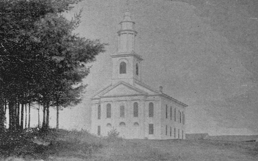
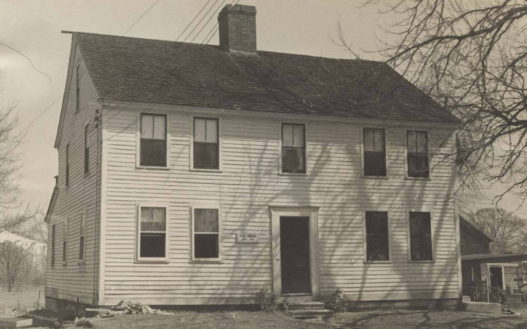
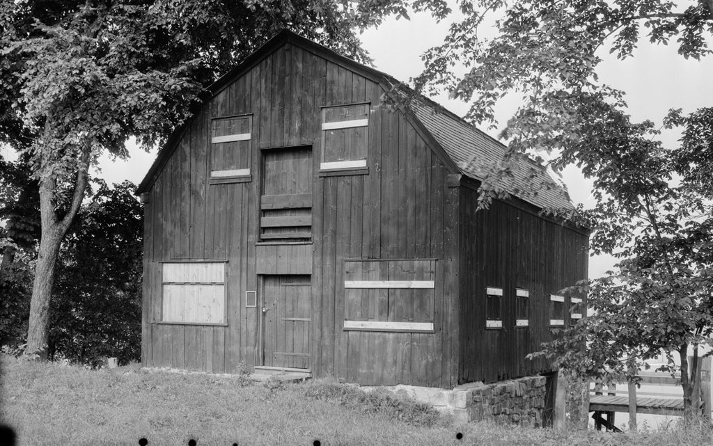
The Buttolph-Williams House on Broad Street in Wethersfield, around 1924. Image from The Early Domestic Architecture of Connecticut (1924).

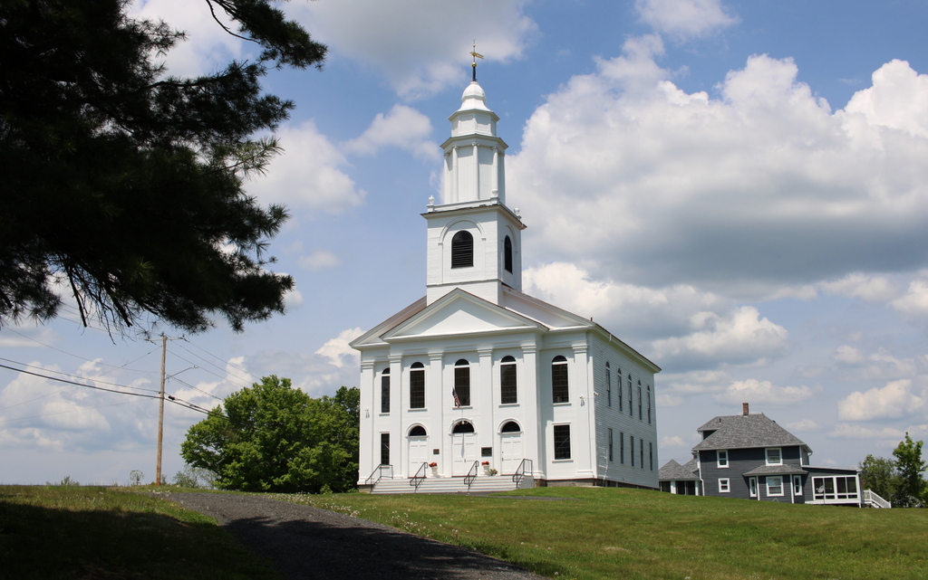
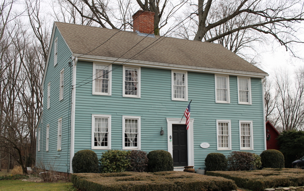
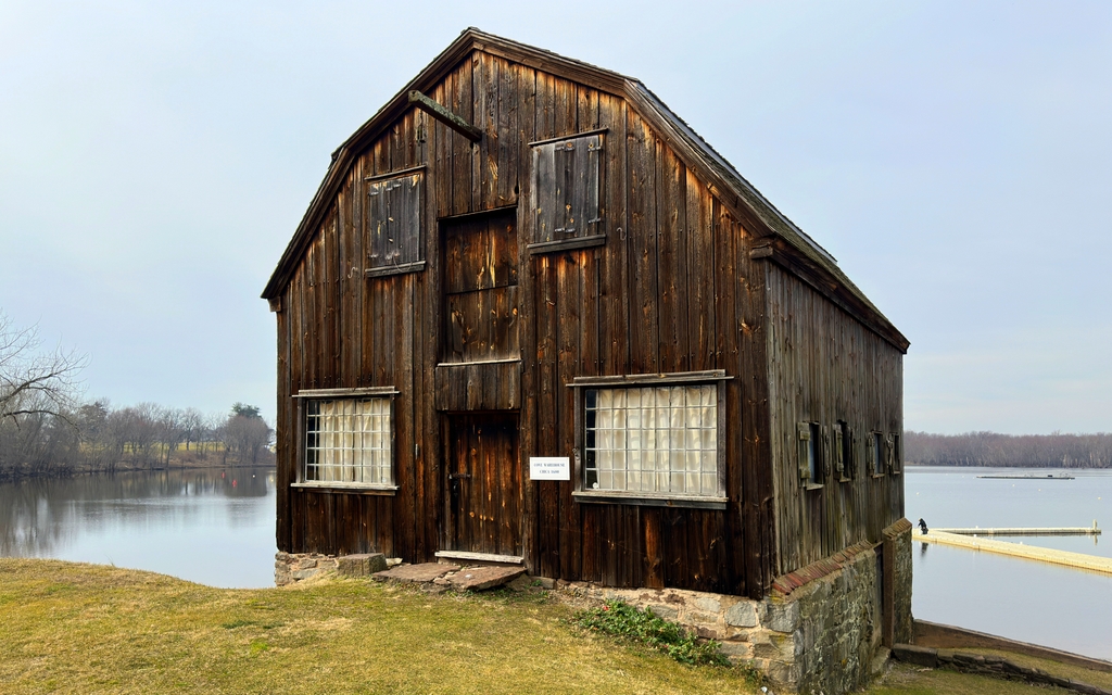
The house in 2024:

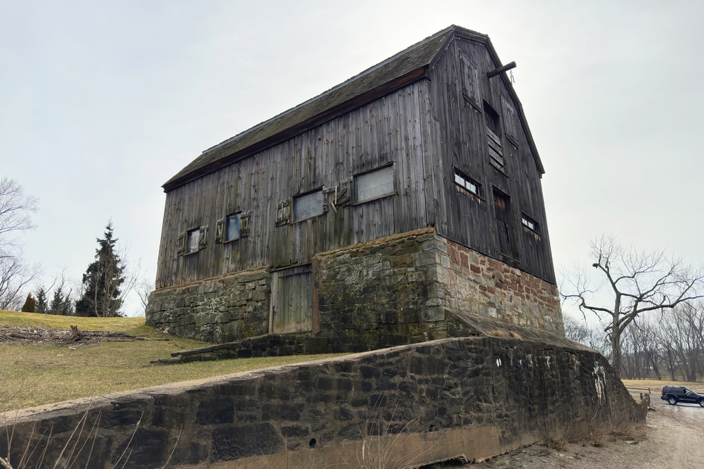
This house is one of the oldest surviving homes in Wethersfield, having been constructed around 1711. It is usually referred to as the Buttolph-Williams House, but this name was based on an incorrect assumption about the age of the house. For many years it was believed to have been built in the 1690s by David Buttolph, although subsequent research has shown that it was actually built around 1711 by Benjamin Belden, who later sold the property to Daniel Williams in 1721.

Although built in the early 18th century, this house has many architectural features that were more typical of post-medieval 17th century homes. Among these were the steeply-pitched roof, the overhanging second floor, and the small diamond-paned casement windows. On the interior, the house has a typical hall-and-parlor layout, with two rooms on the first floor that are separated by the large central chimney.

The house was owned by the Williams family for many years, and during this time it underwent some changes and modernizations, including an ell on the back of the house and new sash windows here on the original part of the house, as shown in the top photo around 1924. By this point the overhang of the second floor was hidden by a layer of clapboards, although the overhang beneath the attic on the gable end of the house was still visible.

By the late 19th century the house was owned by James Vibert, a stagecoach driver who was living here during the 1870 census with his wife Mary and their children Sarah, Kate Mary, Frank, and Anna. James’s real estate was valued at $2,500, and his personal estate was valued at $3,000.

Mary Vibert died in 1884, but James outlived her by many years. He resided in this house until his death in 1913, and his children subsequently inherited the house. Kate and Frank were both living in the house when the top photo was taken, and they remained here until their deaths in the 1940s.

The Viberts were the last residents of the house, and the property was then acquired by the Connecticut Antiquarian and Landmarks Society. In the late 1940s it was restored to its original appearance. This included the removal of the rear ell, the installation of new casement windows, and the removal of the clapboards that had covered the second-story overhang.

Today, the house is still owned by the same organization, which is now known as Connecticut Landmarks. It is operated as a museum by the nearby Webb-Deane-Stevens Museum, and it stands as one of the best-preserved First Period house in the Connecticut River Valley. Because of its significance, it was designated as a National Historic Landmark in 1968.

Henry Hunt House, Enfield, Massachusetts

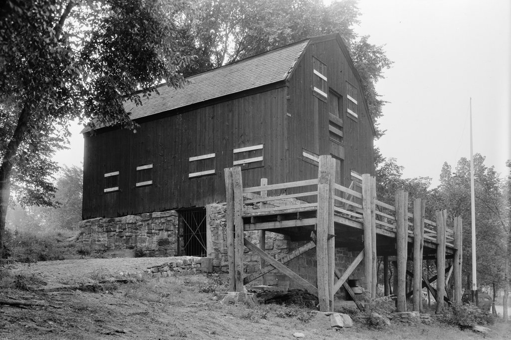
The Henry Hunt House on Webster Road in Enfield, Massachusetts, on October 31, 1928. Image courtesy of the Metropolitan District Water Supply Commission, Quabbin Reservoir, Photographs of Real Estate Takings.

The scene in 2024, in the modern-day town of Ware:

This house, located on Webster Road in the town of Enfield, Massachusetts was the home of Henry H. and Harriet R. Hunt. Based on its architecture, it appears to have been constructed sometime around the late 18th or early 19th centuryies. The Hunts purchased the house from Eugene Tuttle in 1902, and the 35-acre property included the 1 ½ story Cape and a shed, as shown in the top photo. The barn and garage for the farm were located across the street from his home on a separate 38-acre lot.

The home’s location inside what would become the Quabbin Reservoir watershed was soon to be problematic. Hunt farmed the property until selling it to the Massachusetts Metropolitan District Water Supply Commission in May of 1938. He would receive $5,130 for the sale of both of his properties. The home and outbuildings were torn down soon after, and cellar holes filled in. Although the home was well above the reservoir’s waterline, it was deemed necessary to tear down because the home and outbuildings were located inside the reservoir’s watershed.

The first photo was taken on October 31, 1928. The garage and barn would have been located just outside the photo on the left. The site today looks much different. Hunt’s backyard fields have been filled in with trees, and the stonewall has collapsed in sections. The home’s foundation and filled in cellar hole is barely visible below the large fallen tree in the center of the photo. Foundations for the garage and barn can still be seen across the street underneath heavy brush.

Quincy Mansion, Quincy, Massachusetts (2)

The Quincy Mansion, sometime around the late 19th or early 20th centuries. Image courtesy of the Thomas Crane Public Library.

The same scene in 2023:

As explained in more detail in the previous post, the house in the top photo was built in 1848 as the summer home of Josiah Quincy IV, who was at the time serving as mayor of Boston. Quincy died in 1882, and the house was subsequently converted into educational use. In 1896, Dr. Horace Mann Willard opened the Quincy Mansion School here in the house. This was a prestigious boarding school for girls, and he served as principal until his death in 1907. His wife Ruth then continued to run the school until 1919, when she closed it in the midst of declining health.

The property was then sold to Eastern Nazarene College, which relocated here from Rhode Island in 1919. The college used the old house as a dormitory and for classroom space, but the house was ultimately demolished in 1969 to make way for Angell Hall, a modern classroom building. This building is still standing here on the Eastern Nazarene campus, as shown in the second photo.

Quincy Mansion, Quincy, Massachusetts

The Quincy Mansion on East Elm Avenue in Quincy, in 1916. Image courtesy of the Thomas Crane Public Library.

The same scene in 2023:

The house on the right side of the top photo was known as the Quincy Mansion, and it stood on the modern-day campus of Eastern Nazarene College in the Wollaston neighborhood of Quincy. This area was the home of many different members of the prominent Quincy family, including Josiah Quincy I (1710-1784), whose house still stands a few blocks away from here. He was the first in a long line of Josiah Quincys, which included his grandson Josiah Quincy III (1772-1864), who served as mayor of Boston in the 1820s, and his great grandson Josiah Quincy IV (1802-1882), who likewise served as mayor.

It was this fourth Josiah Quincy who owned the house that is shown in the top photo. Like his father, he was a politician, and he held several different state and local offices. Aside from his time as mayor from 1845 to 1849, he was also the president of the Boston Common Council for many years, and also served in the state legislature. His main residence was in Boston, but in 1848 he built this home adjacent to the family homestead here in Quincy, for use as his summer residence.

Quincy died in 1882, and the house was eventually purchased by Dr. Horace Mann Willard, an educator who opened the Quincy Mansion School her in the house in 1896. It was a boarding school for girls, and he served as its principal until his death in 1907. His wife Ruth continued to run the school for more than a decade, until her own failing health forced her to close it in 1919.

The property was then purchased by Eastern Nazarene College, which relocated from Rhode Island to Quincy in 1919. The old house was used for classroom and dormitory space, but over the years the campus expanded with new buildings around it. The house was ultimately demolished in 1969, and it was replaced by Angell Hall, a classroom building that is partially visible beyond the trees on the right side of the second photo. It is located on roughly the same footprint as the old house, and it was deliberately designed to be similar in size and shape to the old Quincy Mansion.

Peacefield, Quincy, Massachusetts

Peacefield, the former home of John Adams and John Quincy Adams, at 135 Adams Street in Quincy, on October 10, 1929. Image courtesy of the Boston Public Library, Leon Abdalian Collection.

The house in 2019:

As explained in more detail in an earlier post, this house was the home of John Adams, John Quincy Adams, and several more generations of the Adams family from the late 18th century into the early 20th century. The house was built in 1731, and it was originally owned by Leonard Vassall, a sugar plantation owner from Jamaica. His daughter Anna later inherited the property, but she and her husband were Loyalists, so they fled to England at the start of the Revolution, leaving the house vacant.

This text is plagiarized from Lost New England

John and Abigail Adams purchased the house from the family in 1787. At the time, the house was much smaller, consisting of the portion on the left side in these photos. It was also in poor condition, from having sat vacant for so long. They had bought it sight-unseen, as they were living in England at the time, where John was serving as the first U.S. Minister to Great Britain. They were disappointed by the condition of the house when they returned here to live, but they soon set about repairing and expanding it. This work included a large addition on the right side, which was built in the 1790s. Abagail oversaw much of this work, since John Adams was away most of the time during the 1790s, serving as the first vice president and then as the second president of the United States.

John Adams retired from politics after losing reelection to Thomas Jefferson in 1800. He spent the last few decades of his life here at this house, which he named Peacefield. Abigail died in 1818, and John died here on July 4, 1826. In one of the most remarkable coincidences in American history, he died on the same day as his friend and political rival Jefferson, which also happened to be the 50th anniversary of the signing of the Declaration of Independence.

John Quincy Adams then inherited the house. At the time of his father’s death he was serving as president, and after losing re-election in 1828 he returned here to Quincy. However, unlike his father, he did not have a quiet retirement. Instead, he returned to politics and served in the U.S. House of Representatives from 1831 until his death in 1848. During that time, he was particularly vocal in his opposition to slavery, and became one of the leading abolitionists of his era.

During the second half of the 19th century, Peacefield was owned by several more generations of the Adams family. John Quincy Adams’s son, Charles Francis Adams, owned it until his death in 1886, and Charles’s sons Henry and Brooks subsequently inherited it. Brooks ended up being the last member of the family to live here at Peacefield, and he remained here until his death in 1927.

The top photo was taken only two years later, in 1929. By this point, the other members of the Adams family had formed the Adams Memorial Society, and this house was preserved as a museum. The property was later transferred to the National Park Service in 1946, becoming the Adams National Historic Site.

Today, the exterior of the house has seen very few changes since the top photo was taken almost a century ago. The house is still operated by the National Park Service, and it is open to the public seasonally for tours. The name of the Park Service unit is now the Adams National Historical Park, and it includes Peacefield along with the nearby birthplaces of John Adams and John Quincy Adams, which stand side-by-side on Franklin Street in Quincy.

Granite Railway Incline, Quincy, Massachusetts (2)

The view looking down the Granite Railway Incline in Quincy, around 1922. Image courtesy of the Thomas Crane Public Library.

The scene in 2021:

As explained in more detail in the previous post, these two photos show the inclined plane of the Granite Railway in Quincy. Unlike the photos in that post, though, which were taken from the base looking up, these ones show the view looking down from partway up the inclined plane.

The Granite Railway was arguably the first commercial railroad in the United States. It began operations on October 7, 1826, and it consisted of horse-drawn cars that transported granite from the quarries in Quincy to the wharves on the Neponset River. From there, the granite was transported by boat to the Bunker Hill Monument, which was the project that had initially led to the construction of the railway.

The railway was expanded in 1830 with the construction of a small branch that led to the Pine Hill Quarry, located at the top of the hill behind where these photos were taken. To reach the top of the hill, civil engineer Gridley Bryant designed an 315-foot-long inclined plane that rose 84 feet in elevation. It consisted of two parallel tracks, one for empty cars ascending to the quarry and another for cars that were descending with granite blocks. The rails were made of granite topped by iron straps, and the tracks also included a cable that ran on pulleys in the center of the tracks. The cable formed an endless loop, and pulled the empty cars up to the top while also controlling the descent of the loaded cars.

Only two years after it opened, the inclined plane was the site of one of the first fatal railroad accidents in the United States. On July 25, 1832, a group of four visitors was ascending the inclined plane in an empty car when the cable failed near the summit, sending the car plummeting down the tracks. Contemporary accounts estimated that the car reached speeds of around 60 miles per hour before derailing at the base. One occupant was killed, two others were seriously injured, and the fourth walked away with minor injuries.

Aside from this accident, there do not appear to have been any other serious incidents here on the inclined plane, and it remained in use into the 20th century. In 1871, the Granite Railway was acquired by the Old Colony Railroad, which in turn became part of the New York, New Haven and Hartford in 1893. Although it was originally built for horse-drawn trains, most of the old Granite Railway was converted into a conventional railroad, as shown in the distance of the top photo. However, because the inclined plane was too steep for regular trains to use, it remained largely unchanged.

In 1901, new railroad tracks were placed atop the old granite rails, and then in 1920 it was converted for truck use, with metal channels to guide the wheels as the trucks ascended and descended. These are visible on the left side of the top photo, while the track in the center of the photo remained in its original 1830 configuration with the old granite blocks, metal strap rails, and pulleys. Then, in 1921, two obelisks were installed at the base of the incline, to commemorate its role in the early history of railroading.

At some point around the mid-20th century, the upper part of the inclined plane was removed when that part of the hillside was quarried. The landscape was further altered when the Southeast Expressway—modern-day Interstate 93—was built along the former mainline of the old Granite Railway in the 1950s. This did not directly affect the inclined plane, but it dramatically changed the view from this particular spot, as shown in the bottom photo.

The last quarry closed in 1963, and the land eventually became part of the Quincy Quarries State Reservation in 1985. This included the surviving portion of the inclined plane, which remains an important civil engineering landmark. Despite all of the changes over the years, the original granite track has remained well preserved over the years, and it still features the pulleys along with portions of the iron straps that were installed atop the granite rails.