Trinity Church, Newport, Rhode Island

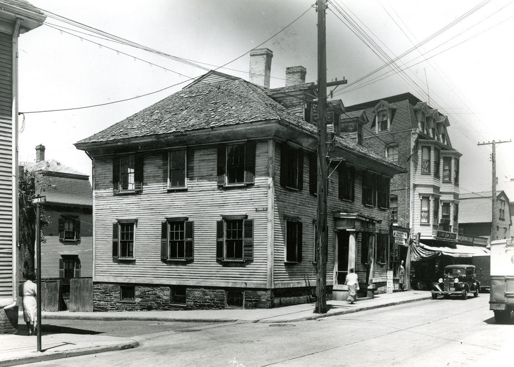
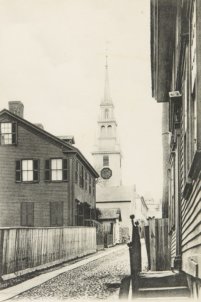
Trinity Church, seen looking east along Frank Street in Newport, around 1901. Image courtesy of the Providence Public Library.
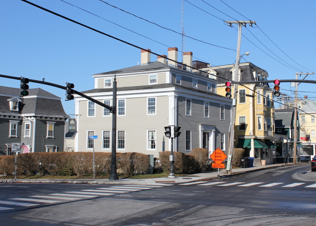
The scene in 2017:

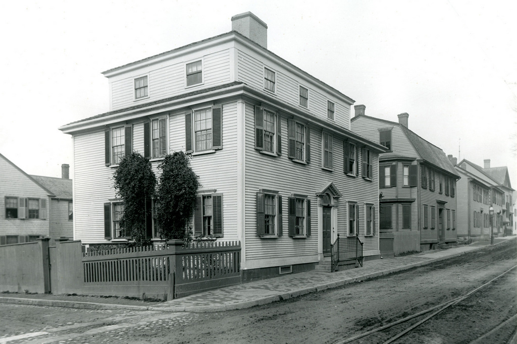
Newport features an impressive collection of colonial-era buildings that have survived to the present day, but one of the most significant of these is Trinity Church, which is seen in these two photos. It was built in 1725-1726 as an Anglican church, replacing an earlier building that the congregation had previously used, and it was the work of local architect and builder Richard Munday. His design was based on the churches of London architect Christopher Wren, and it also bears a strong resemblance to Old North Church, which had been built just a few years earlier.

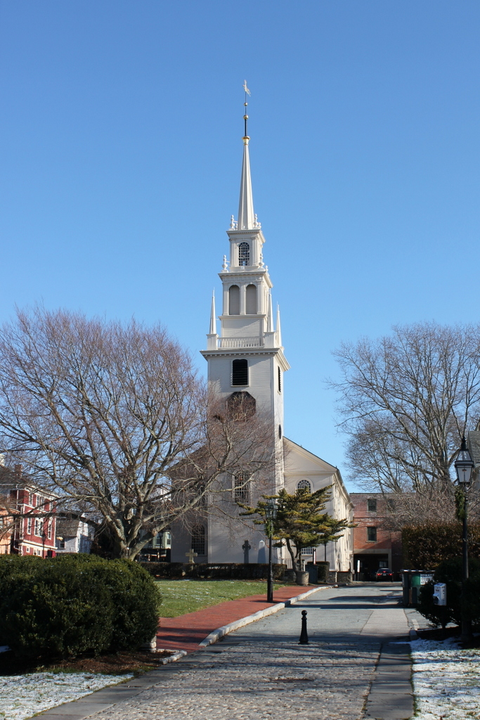
Although the building itself was completed in 1726, the spire was not added until 1741, and it had to be rebuilt in 1768. Another change came in 1762, when the church was expanded by 30 feet. In order to do this, the building was divided in half, the rear section was moved back, and the addition was built in the middle of the two halves. However, it has seen few significant changes since then, and it remains remarkably well-preserved, both on the exterior and interior.

Unlike in most other New England towns, Newport’s colonial-era churches were not built at the head of large public squares. This was an effect of Rhode Island’s legacy of religious tolerance, in order to avoid showing preference to one denomination over another. Because of this, houses of worship tended to have less prominent locations. Here, Trinity Church was situated on a narrow lot bounded by Spring, Church, and Frank Streets. The church building itself filled up most of the lot, with just enough room for a small churchyard on the north and west sides. As the first photo shows, this left the church crowded on all sides, and nearly hidden from view by an assortment of modest houses and commercial buildings.

This situation continued for much of the 20th century. However, a fire in 1973 destroyed the building at the corner of Thames and Frank Streets. This loss helped to spur the redevelopment of the entire block, and during the 1970s the Newport Restoration Foundation acquired properties in the two-block area between Mill and Church Streets. This project was led by the Newport Restoration Foundation’s founder, the tobacco heiress Doris Duke, and it eventually involved the removal of all the buildings here on Frank Street. These buildings held little historical or architectural value, and they were replaced by Queen Anne Square, a public park that stretches from the front of Trinity Church down to Thames Street.

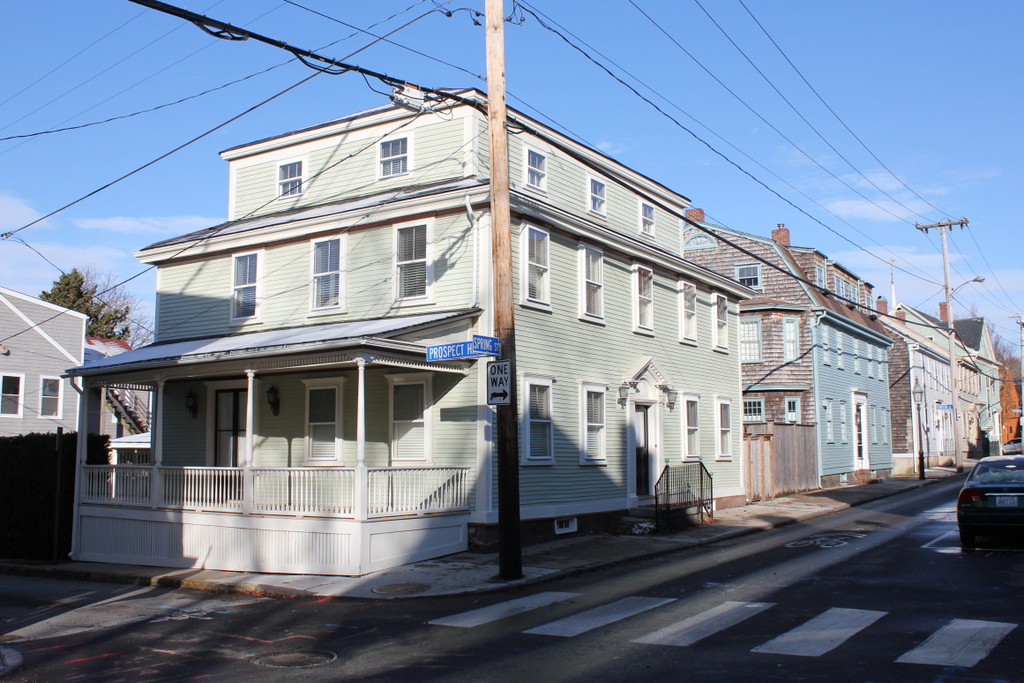
Today, the narrow, cobblestoned Frank Street is still there, although the western end of it is now a pedestrian walkway through Queen Anne Park. With the street no longer cluttered with buildings, Trinity Church is now easily visible from Thames Street and the waterfront area, and it stands as the only surviving structure from the first photo. The nearly 300 year old church is now one a contributing property in the Newport Historic District, a National Historic Landmark district that encompasses much of downtown Newport. However, it is also individually listed as a National Historic Landmark, making it one of 18 buildings in Newport to be recognized as such.

Spring and Cannon Streets, Newport, Rhode Island

The northwest corner of Spring and Cannon Streets in Newport, around 1925. Image courtesy of the Providence Public Library.

The scene in 2017:

The first photo shows a somewhat dilapidated building that stood at the corner of Spring and Cannon Streets. It was probably built sometime in the late 18th or early 19th centuries, and by the time the first photo was taken it was a two-family home. The 1920 census, which had been done a few years later, shows Danish immigrant Andrew Christensen living in one unit with his wife Katherine and their three children. The other unit was rented by French-Canadian immigrant Hector Renaud, his wife Louise, and their daughter Alice. Both men were employed by the navy, with Christensen serving as a chief boatswain’s mate in the navy, and Renaud as a machinist at the U. S. Naval Torpedo Station.

By the time the first photo was taken around 1925, the house appears to have been in poor condition, particularly the roof. It was evidently still occupied, though, because the city directories of the mid-1920s continue to list tenants here. By the 1930 census, it was rented by two more immigrant families, with Italian-born shoe repairer Pasquale Panaggio in one unit with his wife Sarah and four children, and Irish-born gardener Florence C. Sullivan in the other one with his wife Mary and two children.

Today, the old house from the first photo is no longer standing, and was presumably demolished at some point in the mid-20th century. However, there is a different historic building that is still standing on the site. The Newport Historic District building inventory lists it as the Jeremiah J. Sullivan House, with an estimated construction date of 1836-1839. Since this is clearly not the same building that was standing here when the first photo was taken, it must have been moved to this site at some point after the other building was demolished.

The streets have also changed since the first photo was taken. Cannon Street, once a narrow one-block street between Thames and Spring Streets, was significantly expanded in the mid-20th century, becoming part of Memorial Boulevard West. All of the buildings on the south side of the street were either moved or demolished, but the ones on the north side were largely unaffected. As a result, the other buildings from the first photo are still standing today, including the c.1894-1907 J. P. Ancaster House on the left, the c.1859-1876 Patrick Tiernan Building to the right, and the c.1758-1772 James Pitman House further to the right. All three buildings, along with the Sullivan House, are contributing properties in the Newport Historic District, which was designated as a National Historic Landmark in 1968.

Thames Street from Cannon Street, Newport, Rhode Island

Looking east on Cannon Street from the corner of Thames Street in Newport, around 1915. Image courtesy of the Providence Public Library.

The scene in 2017:

The first photo shows the view looking up the hill along Cannon Street, a narrow side street that stretched one block from Thames Street to Spring Street. At the time, the street was lined with a variety of houses, most of which appear to have been built during the 19th century. On the left side, at the corner of Thames Street, was a bicycle shop, and several bicycles are visible in the window, just above the dog on the sidewalk. Aside from the bicycles, the cars in the distance are the only other sign of modernity, as the rest of this scene had probably not undergone any significant changes in several decades.

However, this scene would change dramatically within only a year or two after the first photo was taken. Around 1916, the buildings in the foreground were demolished to build a new post office, which now stands on the left side of the present-day photo. Further changes came in the mid-20th century, when Cannon Street was significantly widened to become Memorial Boulevard West. All of the buildings on the south side of the street were either demolished or relocated, but the few remaining ones here on the north side were largely unaffected, aside from being renumbered with Memorial Boulevard West addresses.

Today, the only surviving building that is easily recognizable from the first photo is the yellow Victorian-style house just to the right of the center in the 2017 photo. According to the Newport Historic District inventory, it was built around 1850. However, it must have been significantly altered later in the 19th century, because its Mansard roof and small turret are more in line with architectural styles of the 1870s and 1880s. The house is hard to see in the first photo, but it is partially visible just behind the first car. At the time, it was the home of Mary Maloney, an Irish immigrant who worked as a laundress and lived here with her sister, her niece, and her nephew. The house has since been converted into a bed and breakfast, and it is now the Burbank Rose Inn.

Spring Street from Prospect Hill Street, Newport, Rhode Island

Looking north on Spring Street from the corner of Prospect Hill Street in Newport, around 1888. Image courtesy of the Providence Public Library.

The scene in 2017:

Downtown Newport has a remarkable collection of historic buildings from the 18th and early 19th centuries, but few street scenes have remained as well-preserved as this block of Spring Street. Aside from the addition of pavement and telephone poles, there are hardly any differences between these two photos, which were taken nearly 130 years apart. However, these buildings were already old when the first photo was taken, so it has been nearly 250 years since there were any major changes to this scene.

Most of the buildings in this scene date back to the mid to late 18th century. Starting in the foreground, at the corner of Spring Street and Prospect Hill Street, is the Lyn Martin House, which was built sometime between 1758 and 1777. The next two houses were also built during this same time period, including the Robert Brattle House at 209 Spring Street, and the Benjamin Howland House further in the distance at 205 Spring Street. Just beyond the Howland House is the Cremin House at 199 Spring Street, which was somewhat newer than its neighbors, having been built around 1785-1790. However, the newest building along this section of Spring Street is the William N. Austin House, which is barely visible on the far right side of the scene. It was built in 1883 at the corner of Spring and Pelham Streets, and replaced a very modest colonial-era building that once stood on the site.

With the exception of the Austin House, all of these buildings date back to Newport’s golden age as a prosperous seaport in the 18th century. However, the American Revolution caused irrevocable harm to Newport’s shipping industry, and the city experienced a long economic decline throughout the first half of the 19th century. As a result, though, there was very little new development in the city during this period, which may have helped contribute to the survival of so many colonial-era buildings, including these ones along Spring Street.

By the time the first photo was taken around 1888, Newport has reinvented itself as one of the nation’s premier resort communities, with the Vanderbilts, Astors, and other Gilded Age families spending their summers in palatial seaside homes. Most of this development was occurring in the southern part of Newport, leaving the downtown area largely intact as a quaint reminder of the city’s past. There are a few signs of progress, including the trolley tracks on Spring Street, but otherwise the scene looks much the same as it would have been a century earlier.

Today, all of the buildings from the first photo are still standing, with only a few significant alterations. The most obvious of these is the addition of the porch on the left side of the Martin House, but other changes include the dormer windows atop the neighboring Brattle House. Further in the distance, there are no noticeable changes to the Howland House, but it is now operated as the Howland House Inn. Along with much of the surrounding area, these buildings are now part of the Newport Historic District, which was designated as a National Historic Landmark in 1968.

Samuel Bours House, Newport, Rhode Island

The house at 175 Spring Street, just south of Mill Street in Newport, around 1932. Image courtesy of the Providence Public Library.

The scene in 2017:

The first photo shows a group of buildings on the west side of Spring Street, just south of the corner of Mill Street. Of these, the oldest might be the Jonathan Gibbs House, which was built around 1771 and still stands on the left side of the scene. However, its much larger neighbor in the center of the photo was probably built around the same time, and was definitely here by 1777, when it was owned by the merchant Samuel Bours. Its architecture is similar to many other colonial-era homes in Newport, with Georgian-style details and a gambrel roof, although it had a rather unusual main entrance, which was located on the side of the house instead of facing the street.

By the early 19th century, the house was owned by Samuel’s son, John Bours. This period coincided with the economic decline of Newport, though, and in subsequent years this former merchant’s house became the home of working class residents. The 1880 census shows two families living here, with carpenter George A. Brown living in one unit with his wife Mary and their son Orin, and florist Carl H. Jurgens living in the other unit with his wife Louise and three children.

The Brown family continued to live here in the house for many years, and the 1910 census shows George, Mary, and Orin all still living here. Orin was 39 years old and working as a mailman by this point, and he lived here with his wife Nellie and their four young children. The first photo was taken a little over 20 years later, in 1932. Nellie had died a year before, but Orin was still living here, and he also rented part of the house to Norwegian-born fisherman Henry Monsen and his wife Josephine.

Orin Brown subsequently remarried to his second wife, Fannie, and he lived here in this house until his death in 1953, at the age of 83. Then, in 1969, the house was purchased by the Newport Restoration Foundation, which also acquired the neighboring Jonathan Gibbs House in the same year. Also in 1969, the organization purchased the c.1811 Alexander Jack, Jr. House, which had previously stood on Levin Street. The house was moved to the corner of Spring and Mill Streets, adjacent to the Bours House, and is visible on the right side of the 2017 photo. All three of these houses were restored in the early 1970s, and they are now part of the Newport Historic District, which is a National Historic Landmark district.

Spring Street from Church Street, Newport, Rhode Island

Looking north on Spring Street from the corner of Church Street in Newport, around 1887. Image courtesy of the Providence Public Library.

The scene in 2017:

These photos were taken directly across Spring Street from Trinity Church, and show the west side of the street, on the block between Church and Mary Streets. A small portion of the churchyard is visible on the far left side of the scene, with an assortment of commercial and residential buildings beyond it. Most of the buildings from the first photo are still standing today, with remarkably few exterior changes, but the one significant difference between the two photos is the building in the foreground, at the corner of Church Street. The first photo shows a colonial-era, gambrel-roofed house that was probably built in the early or mid-18th century. It was probably constructed as a house, but by the late 19th century it included a storefront on the Spring Street facade, which was occupied by the L. Schaefer shoe repair shop. However, the building was demolished sometime around the turn of the 20th century, when the present-day building was constructed on the site.

Further down the street, most of the buildings are still standing. Starting closest to the foreground is the blue and white John Preston Mann House, which was built around 1827. Next to it, with the mansard roof and two-story bay window, is the William B. Sherman House, which was built around the 1860s and is now the Outlook Inn. Further in the distance, barely visible in both photos, is the gambrel-roofed Samuel Barker House. This elegant house was built around 1714, and stands as probably the oldest recognizable building in this scene, predating most of its neighbors by more than a century. Today, all of these buildings, including the turn-of-the-century corner building, are now contributing properties in the Newport Historic District, which was designated as a National Historic Landmark in 1968.