Springfield & Connecticut River from Forest Park (2)

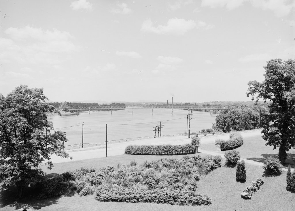
Looking north up the Connecticut River toward downtown Springfield, from Laurel Hill in Forest Park, around 1905. Image courtesy of the Library of Congress, Detroit Publishing Company Collection.
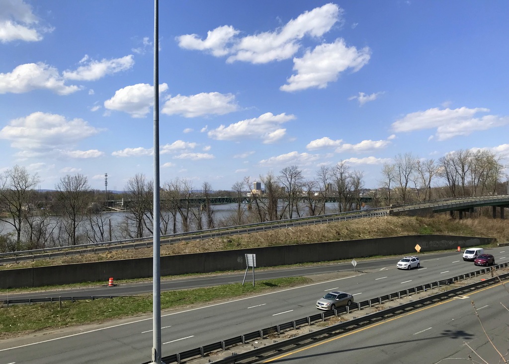
The scene in 2018:

These photos were taken from the same spot as the ones in a previous post, but they show the view looking a little further to the left, directly up the Connecticut River. The location of these photos is Laurel Hill, a bluff on the western end of Forest Park. It was once part of the estate of Everett H. Barney, a wealthy ice skate manufacturer who built his mansion, Pecousic Villa, nearby in 1883. He had intended to build a second home here on Laurel Hill for his only child, George, but George died in 1889 at the age of 26, and Everett instead build a mausoleum here on the hill.

A year later, Everett donated his property – which included the house, a carriage house, and meticulously-landscaped grounds – to the city. This land became part of Forest Park, which had been established 1884 after another benefactor, Orrick H. Greenleaf, gave what is now the eastern section of the park. Barney’s gift extended the park all the way west to the Connecticut River, and his only stipulation was that he and his wife be allowed to live at Pecousic Villa for the rest of their lives.

Perhaps the most scenic part of the newly-expanded park was here at Laurel Hill, where an overlook near the mausoleum provided sweeping views of the Connecticut River and downtown Springfield. In the foreground of the photo is the western entrance to the park, flanked by hedges and a pair of stone markers with the letter “B” carved into them. Longhill Street runs across the foreground, along with trolley tracks that are barely visible in the road. More noticeable from this angle are the poles that supported the overhead wires for the trolleys. The railroad also passed through this scene, although the tracks are hidden from view because they ran further down the embankment between the street and the river.

In the center of the first photo is the South End Bridge, an iron truss bridge that was completed in 1879. It was the third bridge across the river in Springfield, after the Old Toll Bridge in 1805/1820 and the North End Bridge in 1877, and it provided direct access to the city from Agawam and points to the south and west, replacing an earlier ferry that had operated here. Just beyond and to the left of the bridge is the mouth of the Westfield River, which is one of the largest tributaries of the Connecticut River.

Further upstream from the bridge is downtown Springfield, which is marked by an assortment of church steeples and smokestacks. The white, wooden steeple of Old First Church is visible in almost the exact center of the photo, and just to the right of it is the granite tower of the Hampden County Courthouse. Other identifiable steeples include, from left to right, those of St. Joseph’s Church, St. Michael’s Cathedral, Church of the Unity, and South Congregational Church. Aside from these churches, another major landmark is the main arsenal of the Springfield Armory, which is visible to the right, on a bluff overlooking the city.

In the nearly 115 years since the first photo was taken, this scene has undergone some dramatic changes. The most obvious of these is the construction of Interstate 91, which now passes through the narrow space between Laurel Hill and the Connecticut River. This section of the highway was built in the early 1960s, and the project required the demolition of Pecousic Villa, which had been  acquired by the city after Everett Barney’s death in 1916. However, the carriage house was spared, and it still stands on the bluff, just out of view on the far right side of the scene. Both the mausoleum and the overlook on Laurel Hill are also still part of Forest Park, although the modern-day view lacks the same picturesque attributes of the first photo.

Aside from Interstate 91, another major change to this scene is the South End Bridge. Also known as the Julia B. Buxton Bridge, the present-day South End Bridge was completed in 1954, replacing the old 1879 bridge from the first photo. Further in the distance, the Springfield skyline is also very different from the early 20th century. For many years, the city had no skyscrapers because of height restrictions, but these were lifted in 1970 with the construction of the 371-foot Tower Square, which is visible in the center of the 2018 photo. Several other skyscrapers would be built in the ensuing years, including the Monarch Place office building to the right of Tower Square, and the Chestnut Park apartment building a little further to the right.

Despite all of these changes, though, there are some surviving landmarks from the first photo. The churches are no longer the dominant features in the skyline, yet some of them are still standing, including Old First Church, St. Michael’s Cathedral, and South Congregational. The old courthouse is also still there, as is the Armory, but these older buildings are now joined in this scene by modern hotels, office buildings, parking garages, and the silver dome of the Basketball Hall of Fame.

Trinity Methodist Church, Springfield, Mass

Trinity Methodist Church on Bridge Street in Springfield, probably sometime in the 1870s. Image courtesy of the New York Public Library.

The scene in 2018:

Trinity Methodist Church was established in 1844 with about 40 members, many of whom had left the Union Street Methodist Church. The following year, the congregation moved into its first building, which was located on Pynchon Street, across the street from where City Hall is now located. However, as the city grew in the mid-19th century, so did the church membership, and within less than 25 years the Pynchon Street building had become too small for the church.

In 1869, Trinity Methodist relocated to this building here on Bridge Street, as shown in the first photo. Its exterior featured a Romanesque-style design, which was the work of local architectural firm Perkins and Gardner, and it measured 122 feet long and 74 feet wide, with a steeple that rose 185 feet above the street. The entire cost, including the land, was $73,000, which is equivalent to about $1.4 million today. By 1883, the membership had grown to 447 people, and the church also had a Sunday school that was staffed by 38 teachers, and had 377 students.

However, for such a large, elegant church, this site was a rather unusual location, tucked away on a side street with commercial buildings on one side and modest houses on the other. As downtown Springfield continued to grow, the church would become increasingly out of place here on Bridge Street. By the turn of the 20th century, it was the only church on or near Main Street in the mile between Court Square to the south and Memorial Square to the north, with the rest of this corridor becoming almost exclusively commercial.

Around the same time, residents were beginning to move away from the city center. Trolleys, and later automobiles, made it easy for people to live on the outskirts of the city and commute into downtown, and by the mid 20th century many of the downtown churches had followed their parishioners into the suburbs. Among these was Trinity Methodist, which moved out of this building on Bridge Street in the early 1920s, and into a new Neo-Gothic church that still stands on Sumner Avenue, in the city’s Forest Park neighborhood.

The Bridge Street church was demolished in 1922, barely 50 years after its completion, and it was replaced by a three-story commercial block. Named the Trinity Block in recognition of its predecessor, it still stands today, and it is visible on the right side of the 2018 photo. The only other historic building in the present-day scene is the Fuller Block, on the left side of the photo. It was completed in 1887, and both it and the Trinity Block are now listed on the National Register of Historic Places.

Trinity Block, Springfield, Mass

The Trinity Block, at 266-284 Bridge Street in Springfield, around 1938-1939. Image courtesy of the Springfield Preservation Trust.

The building in 2018:

This building was completed in 1923, and it features an ornate, colorful exterior that is decorated with cast stone and terra cotta. The design was the work of local architect Samuel M. Green, and the building was named the Trinity Block, since it was built on the former site of the Trinity Methodist Church, which had been demolished in 1922. The building housed a variety of retail tenants on the ground floor, and the upper floors were used for professional offices.

The first photo was taken about 15 years after the building’s completion, and it shows some of the stores that were located on the ground floor at the time. The most visible of these is F. J. Jensen & Sons, a candy company, bakery, and restaurant that occupied the storefront on the far left. Other businesses in the building during this time included a commercial financing company, a credit bureau, a furrier, an optician, and a shoe store.

Today, the buildings further in the distance along Bridge Street are gone, but the Trinity Block is still standing, with few exterior changes since the first photo was taken some 80 years ago. Shortly after the second photo was taken in 2018, work began on a major renovation of the building, which includes the restoration of the terra cotta exterior. As of October 2019, the work is still ongoing, and the front facade is still behind scaffolding. Because of its architectural significance, the Trinity Block was added to the National Register of Historic Places in 1983, and much more recently, in 2019, it was designated by the city as a single-building local historic district.

Ambrotype Saloon, Springfield, Mass

An ambrotype saloon on the east side of Main Street, between Bridge and Worthington Streets in Springfield, probably sometime in the 1870s. Image courtesy of the New York Public Library.

The scene in 2018:

The first photo depicts a small, trailer-like building that appears to have originally been a traveling photographic studio, as suggested by the words “Ambrotype Saloon,” which are barely visible on the side of the building. Common in the mid-19th century, during the early years of commercial photography, these horse-drawn studios – known as saloons – traveled across the countryside in search of business. They were often built by the photographers themselves, and they frequently served as both a workplace and living quarters for their nomadic owners.  A 1917 article in The Youth’s Companion, written by C. A. Stevens, provides the following description:

Those “saloons” were picturesque little structures, not much more than five feet wide by fifteen feet long; they were mounted on wheels. On each side was a little window, and overhead was a larger skylight; and a flight of three steps led up to a narrow door at the rear. The door opened into the “saloon” proper, where the camera and the visitor’s chair stood; forward of that was the cuddy under the skylight, in which the photographer did his developing.

During the heyday of these photographic saloons, the most popular types of images were daguerreotypes and ambrotypes. The daguerreotype was the first widespread form of photography, and it was common throughout the 1840s and 1850s before being superseded by the ambrotype, which was primarily used in the 1850s and early 1860s. With both of these techniques, each photograph was unique. Like Polaroid images a century later, the image was exposed directly onto the surface, so there were no negatives and no way to reproduce an image, aside from photographing it.

By the time the above photograph was taken in the 1870s, both the daguerreotype and ambrotype had long since been replaced by newer photographic processes. The traveling saloon was also becoming a thing of the past, and this particular one had evidently found a permanent home here on Main Street in Springfield. Its wheels were either gone or hidden behind wood paneling, and it appears to have been connected to a building in the rear of the lot.

According to the handwriting on the back, the building was, at the time, the studio of Warren S. Butler, a photographer who appears in city directories as early as 1872. This is likely the earliest possible date for the first photo, although the city directories do not provide a specific location for his studio until 1877, when he was listed here at this address. Despite the words on the side of the building, it is unlikely that Butler would have been producing ambrotypes here during the 1870s. Instead, his primary photographic medium would have been albumen prints such as cartes de visite and cabinet cards, both of which appear to be visible in the window. Unlike the earlier methods, these were made using negatives, which allowed photographers to produce multiple prints of the same image.

Aside from Butler’s appearance in city directories starting in 1872, there are several other clues that suggest the first photo was taken no earlier than the early 1870s. To the left of the studio is a florist shop that was run by Edmund W. Clarke, who, like Butler, does not appear in any directories until 1872. However, perhaps the most conclusive evidence is the presence of two large brick buildings in the background. Located on the southern side of Worthington Street, these buildings do not appear on the 1870 city map, and were likely constructed at some point in the 1870s.

Similarly, the latest possible date for the first photo is about 1886, the last time that Edmund W. Clarke’s florist shop appears at this address in the city directories. Butler is listed here as late as 1887, but both of these buildings were demolished by the end of that year, when this entire half of the block was cleared in order to build the Fuller Block. This five-story brick building was among the finest commercial blocks in the city when it was completed, and it still stands today, occupying a prominent location at the corner of Main and Bridge Streets.

Main and Bridge Streets, Springfield, Mass

The northeast corner of Main and Bridge Streets in Springfield, Mass, around the 1860s or 1870s. Image courtesy of the New York Public Library.

The scene in 2018:

Up until the mid-19th century, the commercial center of Springfield was along Main Street in the immediate vicinity of Court Square, where most of the important stores, banks, hotels, and other businesses were located. This began to change with the arrival of the railroad in 1839, when a railroad station opened on Main Street, about a half a mile north of Court Square. A second commercial center soon sprung up near the station, with a particular emphasis on hotels and restaurants for travelers.

By 1850, Springfield was experiencing steady growth, but its population was still under 12,000 people at the time, and the Main Street corridor in the downtown area was still not fully developed. There were plenty of businesses and large buildings clustered around Court Square and the railroad station, but the blocks in between consisted of just a few commercial buildings, interspersed by homes, churches, and vacant lots. It would not be until the city’s post-Civil War population boom that this entire section of Main Street would be lined with larger buildings.

The first photo was taken sometime soon after the end of the war, and it shows a couple of the modest, wood-frame buildings that once stood along this part of Main Street. They were located at the corner of Bridge Street, about halfway between Court Square and the railroad station, and they would have been the first things that an eastbound traveler to Springfield would see on Main Street, after coming across the old covered bridge and walking up Bridge Street. Dwarfed by a massive tree – probably an elm – on the left side, these small, two-story buildings were probably constructed sometime in the 1850s. By the time the first photo was taken, they housed, from left to right, sign painter James C. Drake, wholesale cigar dealer C.H. Olcott, and stove dealer Edmund L. DeWitt.

These buildings stood here until the mid-1880s, and they were probably among the last surviving wood-frame buildings on Main Street in the downtown area. However, they were demolished to make room for the Fuller Block, a large five-story brick building that was completed in 1887. Like the other new commercial blocks that were constructed in the late 19th century, it housed retail shops on the ground floor, with professional offices on the upper floors. However, it featured a unique Romanesque-style design that incorporated Moorish elements, such as the horseshoe arches above the fifth floor windows, and a large onion dome that originally sat atop the right-hand corner of the roof.

Today, some 150 years after the first photo was taken, there are no surviving landmarks except for the streets themselves. However, the Fuller Block that replaced these older buildings is still standing, and aside from the loss of the onion dome its exterior has remained well-preserved. It is one of the finest 19th century commercial blocks in the city, and in 1983 it was added to the National Register of Historic Places.

Wells Block, Springfield, Mass

The building at 250-264 Worthington Street in Springfield, around 1938-1939. Image courtesy of the Springfield Preservation Trust.

The scene in 2018:

This brick, four-story Italianate building was built in 1876 by Abner B. Abbey, a coal and lumber dealer. However, the expense of the building ended up being too much for him, and the following year it was sold at a foreclosure auction to Jerome Wells, a merchant from Chicopee who was also the president of the First National Bank. He rented the building to both commercial and residential tenants, with two storefronts on the first floor and apartments on the three upper floors.

During the 20th century, the upper floors were used primarily as a boarding house, which in 1916 was named the Avon Hotel. By the time the first photo was taken in the late 1930s, the hotel was being run by Clara LeDuc, who rented rooms to 10 boarders. Based on the 1940 census records, they held a range of working-class jobs, including several restaurant workers, a theater custodian, a machinist, a painter, a cotton mill knitter, a boiler maker’s helper, and a photographer. Of those who were employed full-time, their salaries ranged from the machinist, who made $740 per year ($13,400 today), to the painter, who made $1,400 ($25,300 today). Along with the boarders, Clara also lived here with her father Adalard Demers and her husband, William, who earned $1,450 as a steamfitter at the Armory.

The 1940 census also shows at least one other boarding house that was located here in the building. It was run by Nettie Laurance, a 56-year-old widow whose niece, Dorathy Bickford, lived here with her and worked as the housekeeper. They had eight tenants at the time, most of whom had jobs similar to those in the Avon Hotel. Below these two boarding houses, the two ground floor storefronts were occupied by linoleum dealers Cunningham & O’Shaughnessy on the left, and paint dealer A.E. Hale & Co. on the right. Other nearby stores included the Reliable Shoe Repairing Company in the one-story building on the left, and the Wells & Wells gift shop on the far right.

In 1946, the upper floors were badly damaged by a fire, and they were largely vacant for many years. However, the ground floor remained in use during this time, and for much of the late 20th century the storefront on the left was the home of the Budget Box thrift store. More recently, though, this section of Worthington Street has been reinvented as downtown Springfield’s dining district, and both of the storefronts in this building now house restaurants. Overall, the building’s exterior appearance has not changed much since the first photo was taken some 80 years ago, and both it and the neighboring building to the right are now listed on the National Register of Historic Places.