Summer Street, Boston

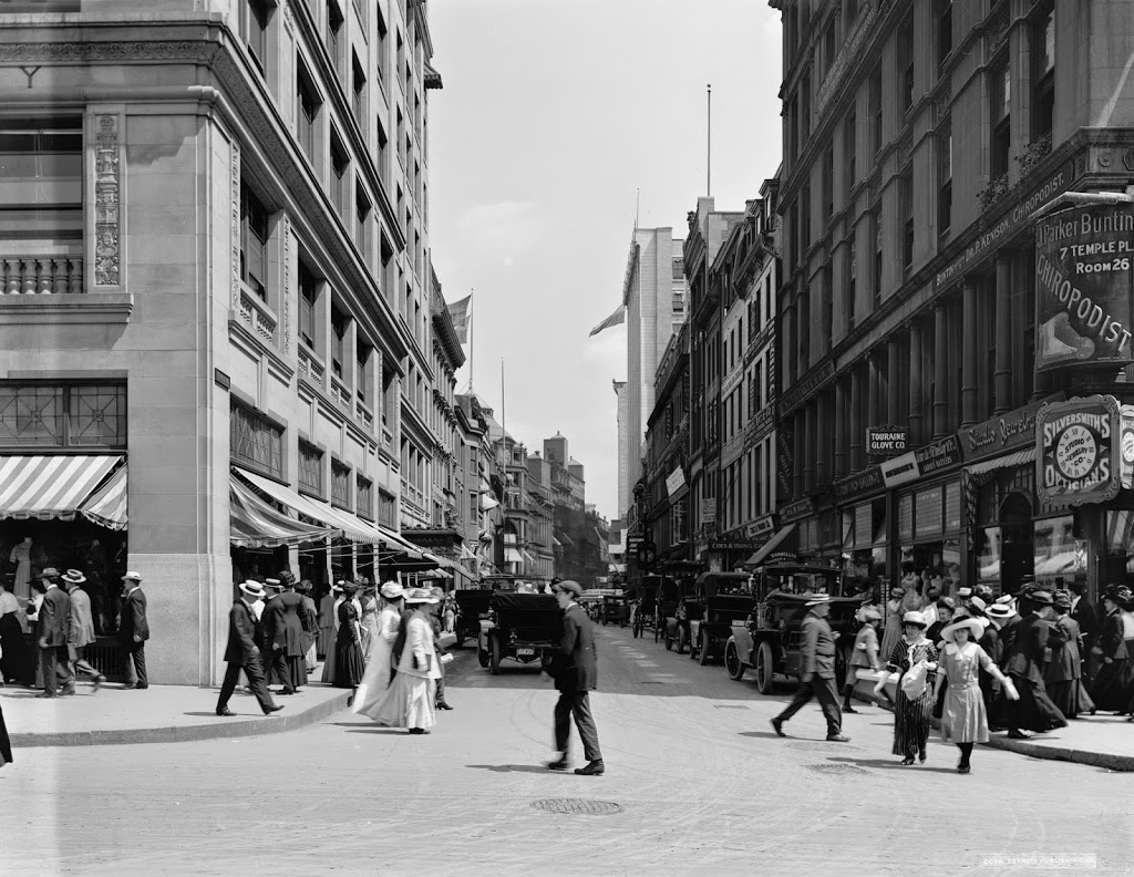
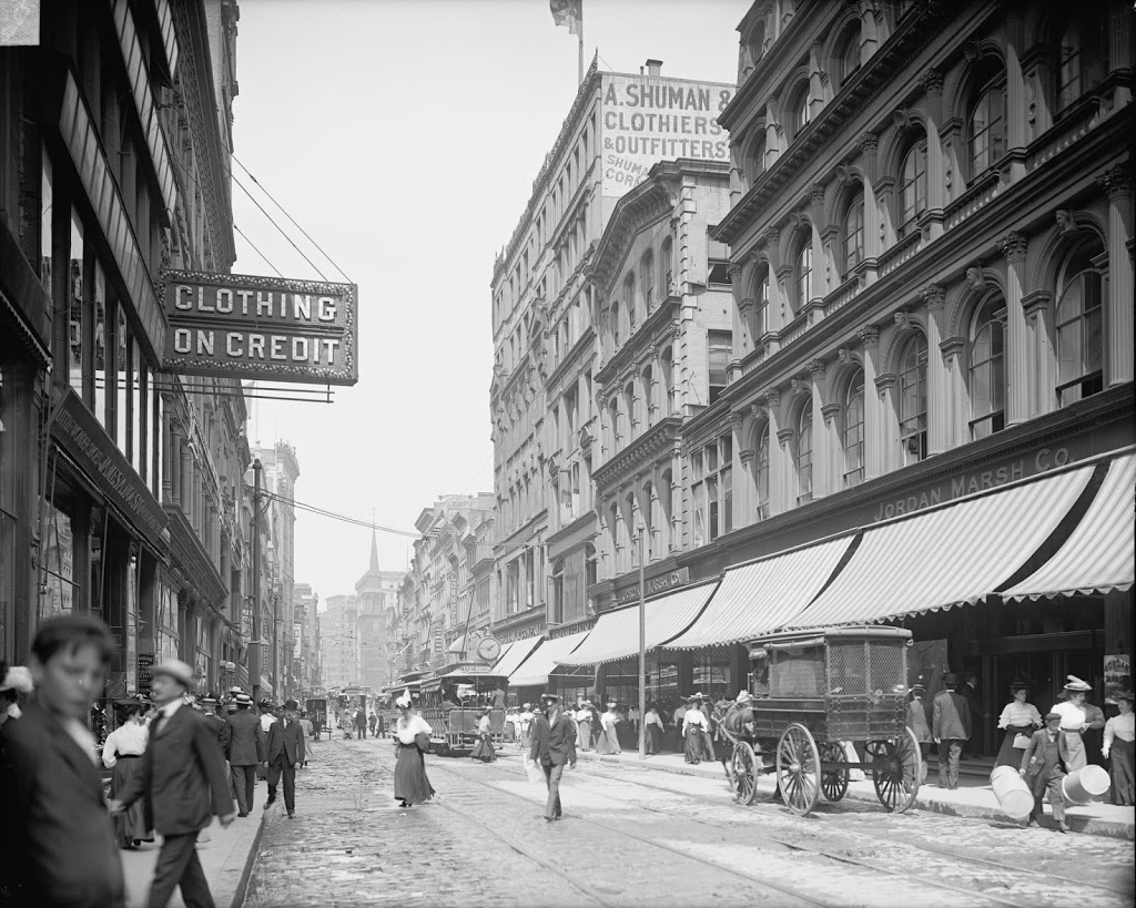
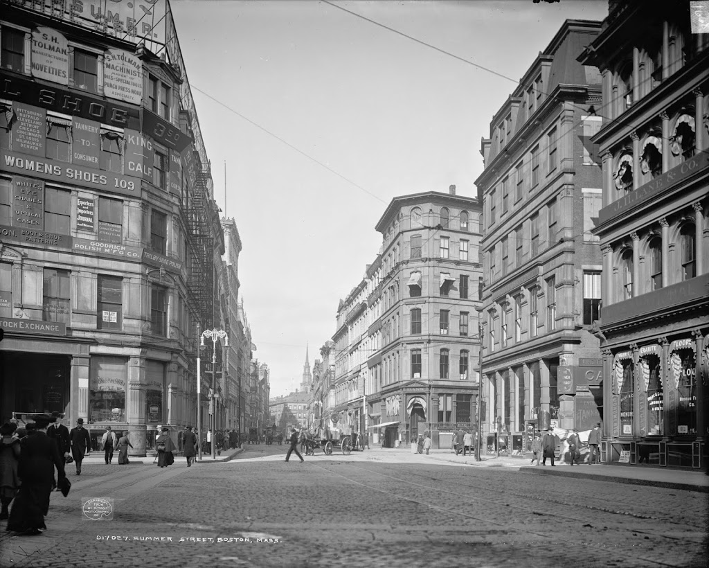
Looking up Summer Street from Lincoln Street, around 1904. Image courtesy of the Library of Congress, Detroit Publishing Company Collection.

261_1904c-loc

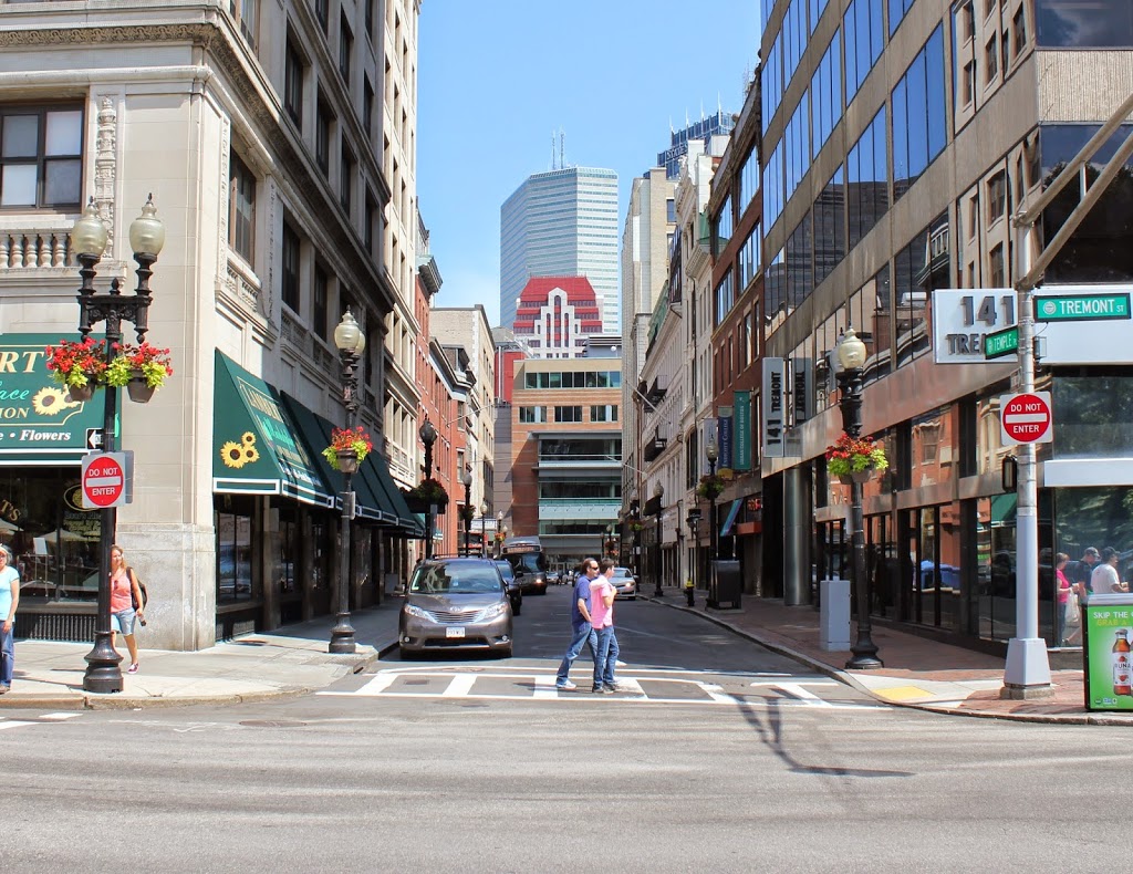
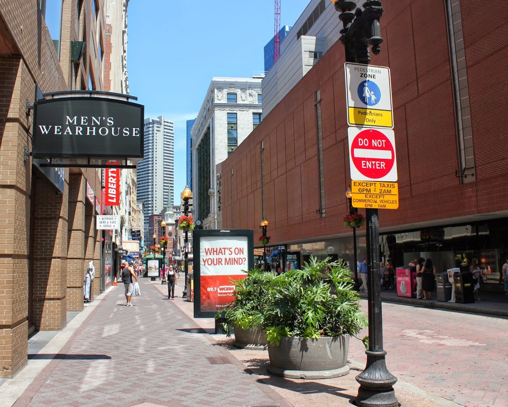
The same view in 2014:

261_2014

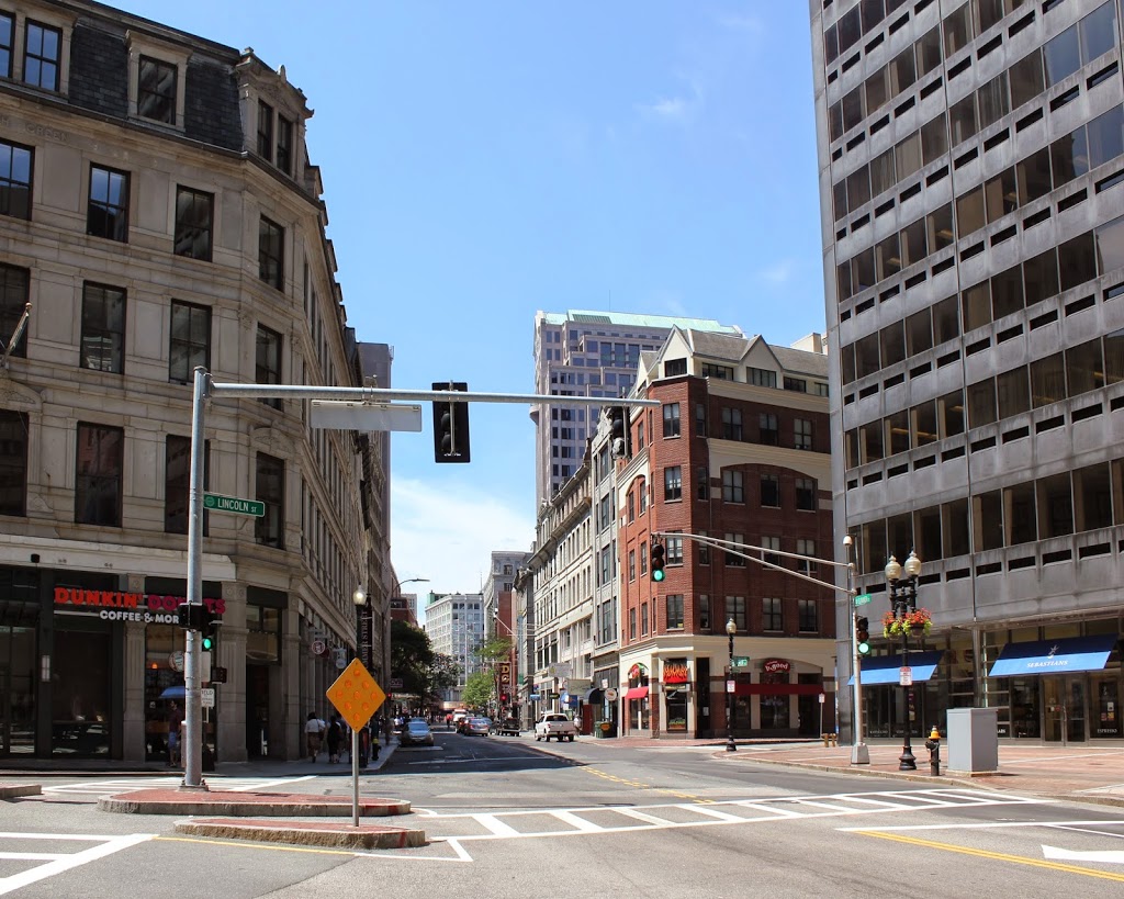
Although this is part of Boston’s Financial District, this part of Summer Street doesn’t look too dramatically different from 110 years ago.  Several of the older buildings are still recognizable, with the most noticeable being the one on the far left.  Known as the Church Green, it is named after the New South Church that once stood on the site.  It was demolished in 1868, and replaced by a bank building.  That building burned just a few years later in the 1872 fire, and the present-day building was completed in 1873.  In the 1904 photo, it advertised a number of shoe-related services, including shoe polish, womens shoes, and boot and shoe patterns.  Today, the first floor has a Dunkin Donuts and a Chipotle.

Temple Place from Tremont Street, Boston

Looking up Temple Place from Tremont Street, facing away from Boston Common.  Photo taken between 1910 and 1916, courtesy of the Library of Congress, Detroit Publishing Company Collection.

258_1910-1920c-loc

The scene in 2014:

258_2014

This area was a major shopping center around the turn of the last century, and it still is today.  Temple Place doesn’t look all that different, with many of the same buildings still there.  However, the street has since been truncated at Washington Street (the next block down), with Macy’s and other retail stores occupying the area where the street (actually called Avon Street on the other side of Washington) used to be.  The building on the far left, the R.H. Stearns Building, is essentially unchanged, although it has different tenants now.  The R.H. Stearns department store occupied the building from its completion in 1908 until 1977, when the company closed.

Milk Street, Boston

Looking down Milk Street, just past Old South Meeting House, around 1911. Image courtesy of the Library of Congress, Detroit Publishing Company Collection.

The same street in 2014:

The Library of Congress estimates that the first photo was taken between 1910 and 1920, but the license plate on the car appears to be dated 1911, which would, assuming the driver’s registration was current, place the photo around that time.  It captures a scene, frozen in time, not long before some major world events began to happen.  At the time, the Titanic was still under construction, the czar still ruled in Russia (for the next few years), and World War I was just a couple years away.  Automobiles such as the one in the photo were still a fairly new concept, and although none are seen in the photo, horse-drawn carriages were still a common sight around Boston.

The world has dramatically changed since the first photo was taken, but the street scene here isn’t completely altered – several buildings are still there, including the one on the far left, and the one just over a block down the street on the right.  Based on their architectural styles, they were probably brand-new in 1911, but today they don’t look all that different from the outside.

Washington Street, Boston (2)

Another view looking up Washington Street, taken from the corner of Temple Place, around 1906. Image courtesy of the Library of Congress, Detroit Publishing Company Collection.

256_1906c-loc

The scene in 2014:

256_2014

This view of Washington Street was taken a couple blocks back from the one in this post, and shows some of the drastic changes in the Downtown Crossing area.  In this area, Washington Street is closed to most traffic, allowing pedestrians easy access to the stores on both sides of the street.  It’s one of the few cases where the “now” photo actually has less traffic than the “then” photo.

Today, Downtown Crossing is still a major shopping district, but almost all of the buildings in the 2014 photo are new – probably the only easily recognizable building in both photos is Old South Meeting House, which is three long blocks down the road.

Washington Street, Boston (1)

Looking up Washington Street from near Franklin Street, toward Old South Meeting House, around 1906. Image courtesy of the Library of Congress, Detroit Publishing Company Collection.

255_1906c-loc

Washington Street in 2014:

255_2014

These two photos were taken just a block away from the ones in this post.  This particular view illustrates some of the changes that Washington Street has seen over the past century.  Long before even the first photo was taken, Washington Street was once the only way in or out of Boston by land (hence, “one if by land, two if by sea,” with the land part referring to passing through here).  However, subsequent landfill in the 19th century expanded Boston’s land area, and allowed for other routes in and out.

Today, this section of Washington Street is closed to most traffic, and is at the center of the Downtown Crossing shopping district.  In that sense, not much has changed – 100 years ago, this area was also a major commercial district, although not many of the buildings survive today.  The most prominent is the Old South Meeting House, which has stood at the corner of Washington and Milk Streets since 1729.  A few other buildings on the right-hand side, both in front of and behind the church, still exist today, but everything in the foreground has significantly changed.

State Street, Boston

The view looking up State Street from Chatham Street, in 1875. Photo courtesy of Boston Public Library.

253_1875-bpl

The same view, around 1905. Photo courtesy of Library of Congress, Detroit Publishing Company Collection.

253_1905c-loc

State Street in 2014:

253_2014

These three views show the progression of high-rise buildings in Boston’s Financial District, with the 1875 photo showing mostly 4-5 story brick buildings, followed by taller buildings in the turn-of-the-century photo, and finally the modern steel and glass skyscrapers in the 2014 photo.  One constant in all of the photos, though, is the Old State House, which predates even the first photo by over 150 years (consider that – in the 1875 photo, the building was closer in time to the present day than to the year it was built).  It’s remarkable to be able to see it in all three photos, though, because the views clearly show the colonial-era building steadily becoming dwarfed by its surroundings.

Another building (possibly the only other one) visible in all three photos is the Western Union Telegraph Company building (the one with the company’s name painted on the side in the photo).  It was brand-new in the 1875 photo, having been built approximately a year earlier, and it stood out among its neighbors.  Today, it’s still there, although extensively modified and barely noticeable, and is probably the shortest building on either side of State Street in this view.