Worcester Common, Worcester, Mass (2)

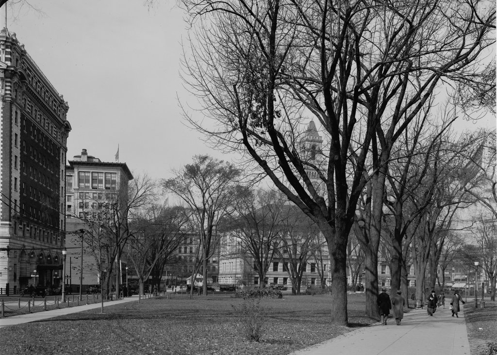
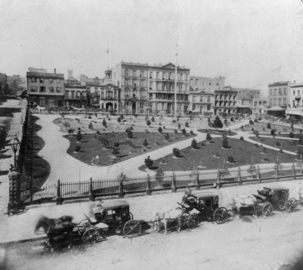
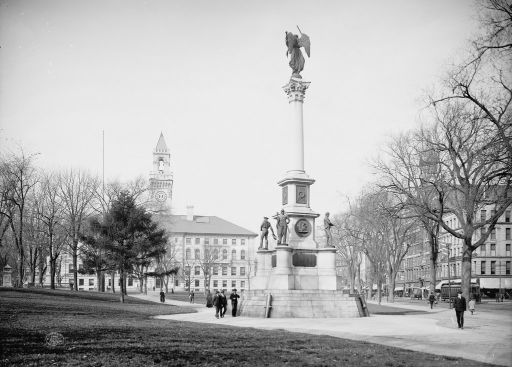
Another view of the Worcester Common, taken looking west from the corner of Church and Front Streets, around 1906. Image courtesy of the Library of Congress, Detroit Publishing Company Collection.
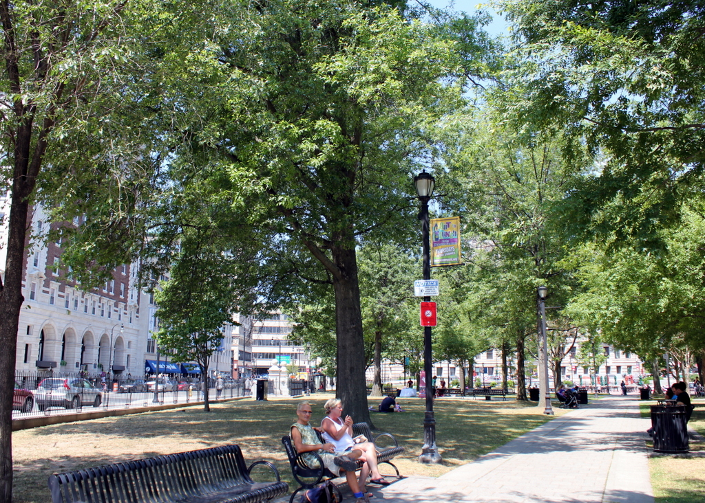
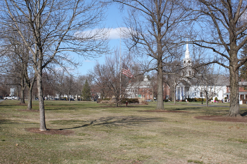
1024_1906c-loc

The Common in 2016:

1024_2016
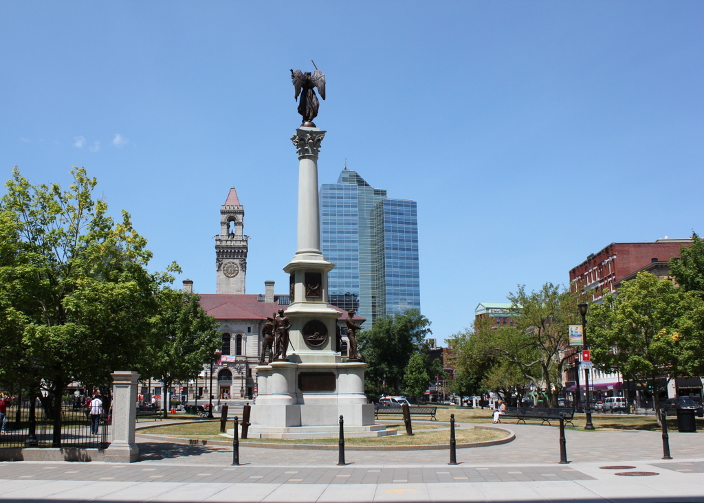
Taken from the northeast corner of the Common, on the other end of Church Street from an earlier post, this view shows the Soldiers’ Monument in the center, with City Hall to the left and Front Street to the right. The monument is the oldest feature in the first photo; it was dedicated in 1874 in honor of Worcester’s fallen soldiers and sailors of the Civil War, and was designed by prominent sculptor Randolph Rogers.

Along with the monument, several other buildings remain from the first photo, including the 1898 City Hall. On the far right, partially hidden by trees, are two 19th century commercial buildings. Both were designed by Fuller & Delano, a Worcester-based firm that was responsible for many other significant buildings in the city. The tall red brick building is the Chase Building, which was built in 1886 and, although the top floors were later altered, it is still standing. To the right of it, at the corner of Commercial Street, is the Ransom C. Taylor Block, built around 1897.

Today, the only particularly obvious change to this scene is the Worcester Plaza building in the distance. Originally built as the Worcester County National Bank Tower, it was completed in 1974, and is tied for the record of the tallest building in the city.

Worcester Common, Worcester, Mass

The Worcester Common, seen facing west from the corner of Franklin and Church Streets, around 1914-1920. Image courtesy of the Library of Congress, Detroit Publishing Company Collection.

1022_1910-1920-loc

The Common in 2016:

1022_2016
Today, Worcester is the second-largest city in New England, and the Common has been at the center of the city ever since it was a small colonial settlement in the 17th century. Set aside in 1669, more than 50 years before Worcester was formally incorporated as a town, the Common was originally used as a training ground for the militia, burial ground, and the site of the meetinghouse. It was once much larger, but as the city has grown up around it, this common land has steadily shrunk to its current dimensions, and at one point in the 19th century even had railroad tracks running across it.

The first photo was taken shortly after the completion of several prominent buildings along the Common, which are still standing today. These buildings, designed in the popular Classical Revival style of the turn of the 20th century, include the 1913 Bancroft Hotel on the left, the 1915 Park Building to the right of it, and the 1898 City Hall, which is mostly hidden by trees in the distance on the right. Along with the Common itself, all three of these buildings are now listed on the National Register of Historic Places.

Fort Gilbert Monument, West Brookfield, Mass

The Fort Gilbert Monument at the corner of North Main and Winter Streets in West Brookfield, around 1902-1927. Image courtesy of the Longmeadow Historical Society, Emerson Collection.

956_1902-1927 lhs

The monument in 2016:

956_2016
The town of Brookfield, which originally included present-day North, East, and West Brookfield, was first settled by Europeans in 1660 as the town of Quaboag. At the time, it was in a very isolated location in central Massachusetts, some 25 miles from the towns in the Connecticut River valley and twice as far from Boston and the other towns along the coast. Because of this, it was very vulnerable to an Indian attack, which occurred in 1675 during King Philip’s War. The town was destroyed and abandoned, with many of the settlers moving back to where they had previously lived.

Over a decade later, settlers returned, and this time they came better prepared for potential raids. They built four forts, including Fort Gilbert here in the western part of the town. It included barracks for soldiers and, if necessary during a raid, to house the families of the town, and it was surrounded by a stockade. The fort was still standing during the French and Indian War, although it was far removed from any battles, and some of its remains were still visible well into the 19th century.

Today, any evidence of the fort is long gone, but the site is marked with this simple monument, which was put here around 1900. It is located in a small park next to the West Brookfield Elementary School, on North Main Street just west of the town common.

Town Green, Longmeadow, Mass

Facing north on the Town Green in Longmeadow, on July 5, 1903. Image courtesy of the Longmeadow Historical Society, Emerson Collection.

946_1903-07-05 longhs

The Green in 2016:

946_2016
Longmeadow’s Town Green is a historic district on the National Register of Historic Places, and it is surrounded by a number of buildings dating back to the 18th and 19th centuries. There have been some changes since the first photo was taken, particularly to the church and its parsonage. The church, surprisingly, is the same one from the first photo, just with some significant alterations, and the parsonage is the same building, just in a different location. It is located in about the center of the 1903 photo, just north of Williams Street, but it was moved to the other side of the church around 1921, where it is visible on the far right in the 2016 photo. The large Colonial Revial-style Community House, which was built on the old site of the parsonage in 1921, is the newest building in this scene and the only one that does not appear in the 1903 photo.

Lost New England Goes West: Portsmouth Square, San Francisco (2)

Facing west across Portsmouth Square from Kearny Street in San Francisco, around 1866. Image courtesy of the Library of Congress, Lawrence & Houseworth Collection.

892_1866c loc

The scene in 2015:

892_2015
This earlier post shows Portsmouth Square in 1851, facing the north side of the square. Here, this first photo shows the west side of the square about 15 years later, after it had become a landscaped park. Anything from the first photo that was still standing 40 years later was destroyed in the 1906 earthquake; the photo in this earlier post shows the square, facing the opposite direction, in the aftermath of the disaster, when the square was covered in tents for displaced residents. Today, nothing is left from the original photo except for the square itself, which is still a public park and is located within the city’s Chinatown neighborhood.

This post is part of a series of photos that I took in California this past winter. Click here to see the other posts in the “Lost New England Goes West” series.

Lost New England Goes West: Union Square, San Francisco

Union Square, seen from the corner of Post and Stockton Streets shortly after the April 18, 1906 earthquake. Image courtesy of the Library of Congress, Detroit Publishing Company Collection.

869_1906c loc

Union Square in 2015:

869_2015
Today, Union Square is one of the premier shopping areas in San Francisco, but 110 years ago it was, like the rest of the city, covered in earthquake debris and surrounded by burned-out buildings. The most prominent building in the first photo is the St. Francis Hotel, on the right side of the scene. Completed only two years earlier, the building survived the earthquake itself with minimal damage, but a combination of damaged firefighting infrastructure and poor city leadership allowed fires to spread throughout much of the city. The hotel was completely gutted by the fire, as the first photo shows, but it remained structurally sound. Soon after the photo was taken, a temporary hotel was built in the middle of the square, where it housed guests until the burned-out hotel reopened a year and a half later. Now known as the Westin St. Francis, it has been expanded several times, and today it still stands overlooking Union Square.

Another Union Square landmark from the first photo is the Dewey Monument, located in the center of the square. It was designed by sculptor Robert Aitken, whose later works included the pediment atop the US Supreme Court Building, and it was dedicated in 1903 by Theodore Roosevelt, in honor of Spanish-American War hero Admiral George Dewey and recently-assassinated President William McKinley. The 85-foot tall monument survived both the earthquake and the subsequent fires, and it is still standing in Union Square today, although it is now partially hidden by the palm trees around it.

This post is part of a series of photos that I took in California this past winter. Click here to see the other posts in the “Lost New England Goes West” series.