Old Man of the Mountain, Franconia, New Hampshire

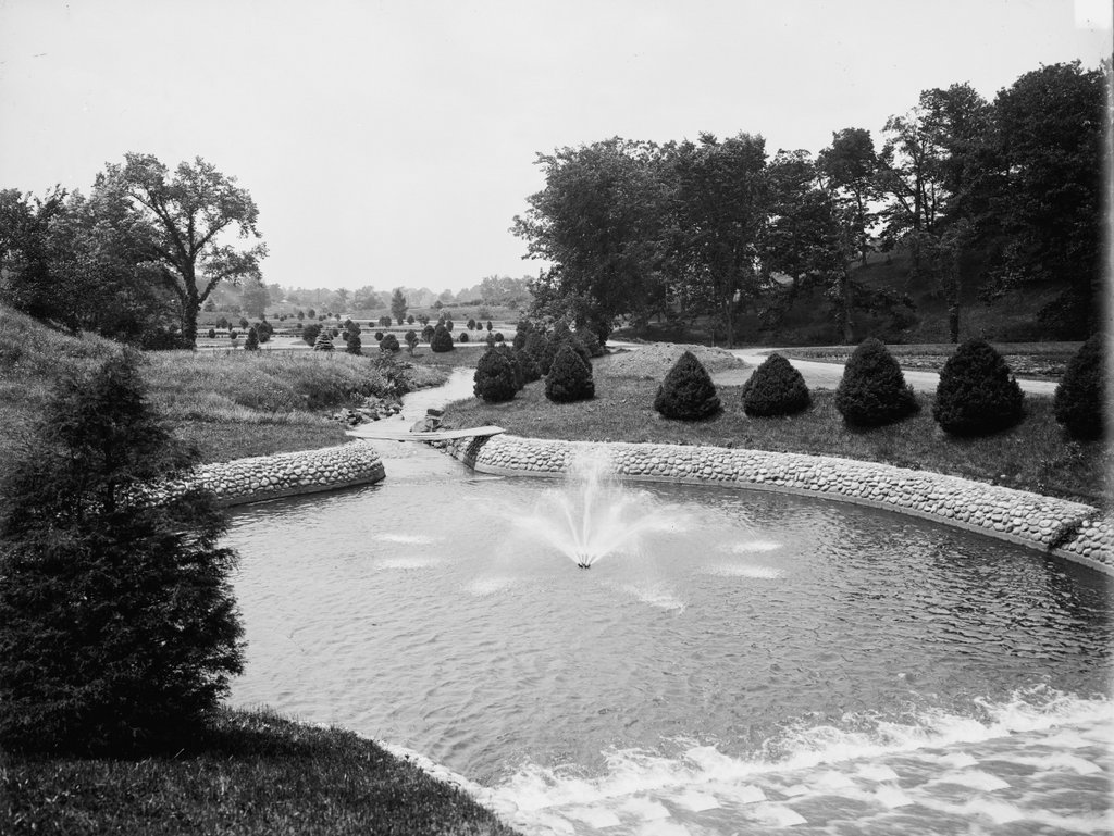
The Old Man of the Mountain, seen from Profile Lake at the base of Cannon Mountain, around 1890-1901. Image courtesy of the Library of Congress, Detroit Publishing Company Collection.
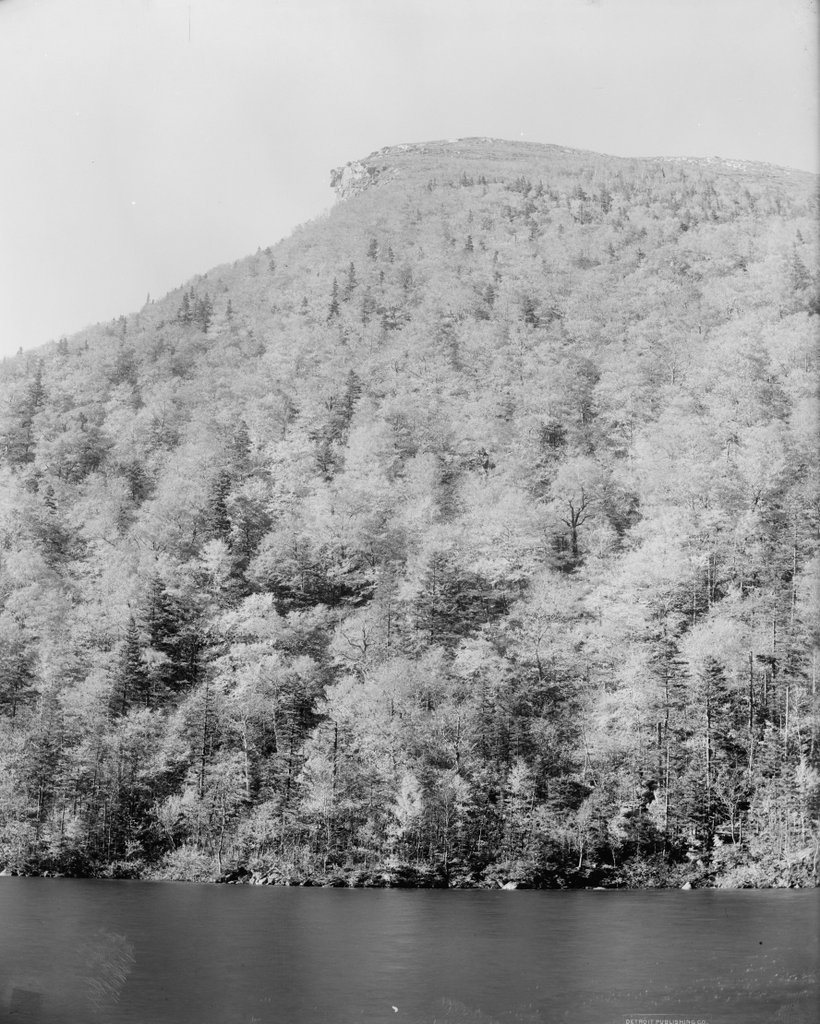
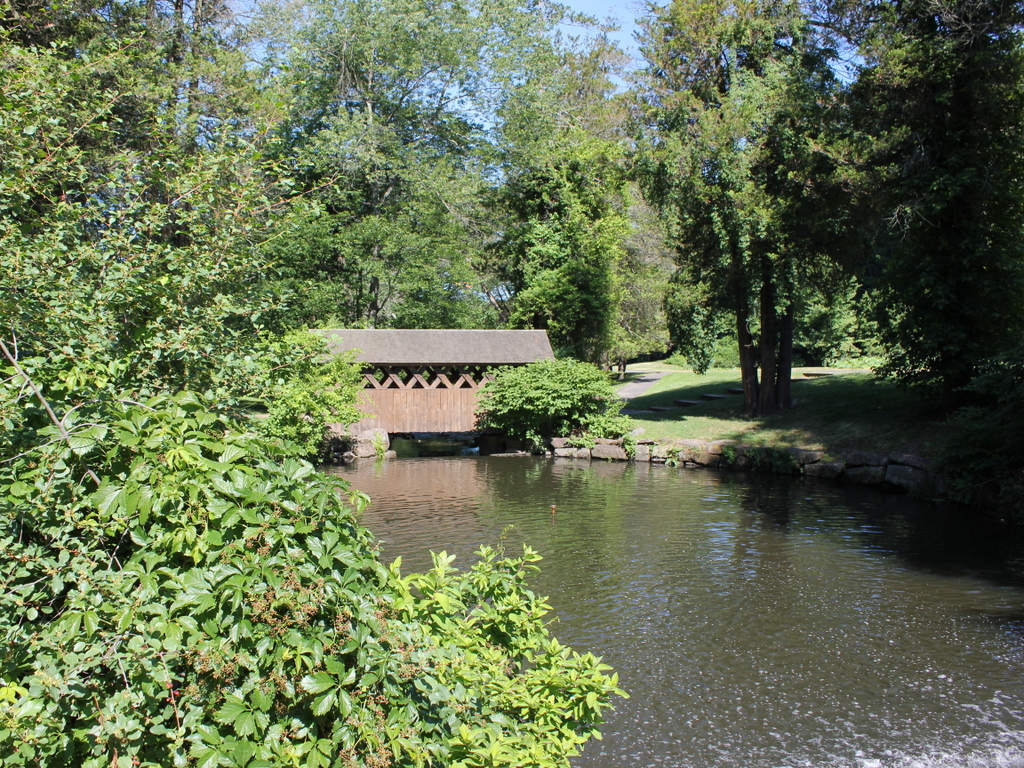
The scene in 2018:

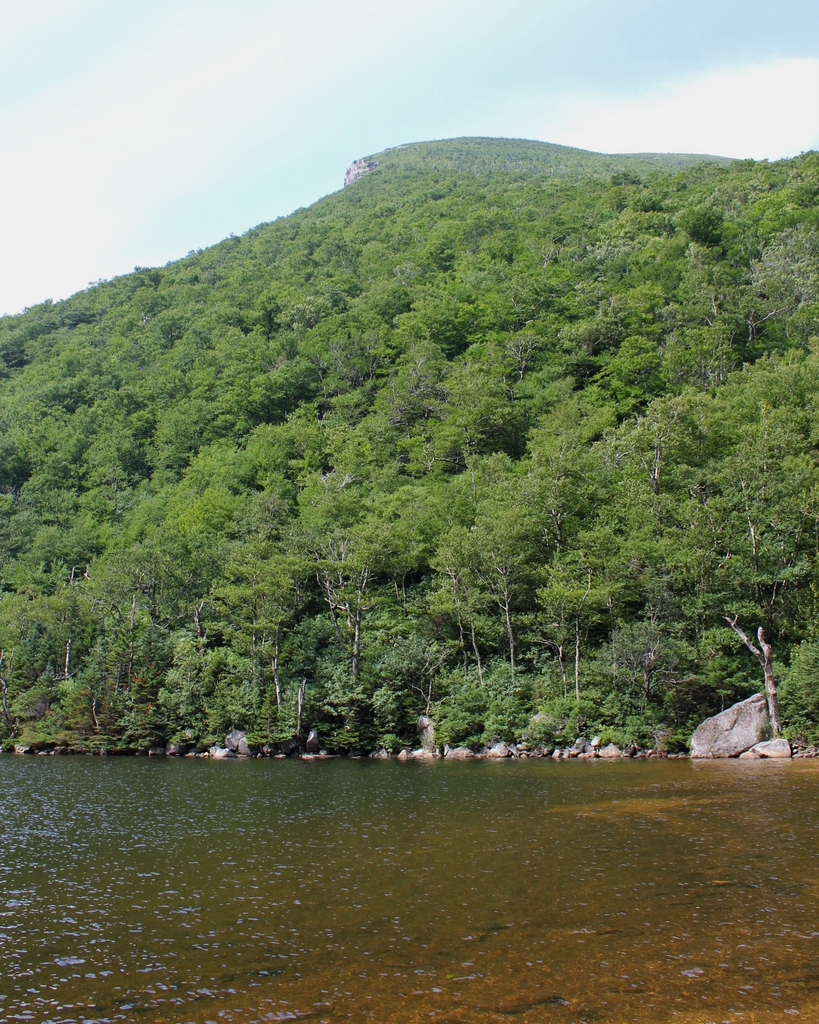
The Old Man of the Mountain was previously featured on this blog many years ago, in a post that showed a closeup of the rock formation, before and after its collapse. Unlike that view, however, this scene here shows not just the rock formation, but also its surroundings, including the east side of Cannon Mountain and Profile Lake at its base. This is, more or less, the view that most visitors would see of the Old Man from the ground, without the aid of binoculars or telephoto lenses.

The iconic granite profile was formed at some point after the last ice age, as a result of erosion at the top of the cliff. It stood 1,200 feet above the surface of Profile Lake, and it was on the side of Cannon Mountain, which rises a total of 4,080 feet above sea level. Cannon Mountain forms the western side of Franconia Notch, an important mountain pass through the White Mountains, and by the early 19th century the Old Man of the Mountain had become a notable landmark for travelers passing through here.

The first recorded mention of the rock formation came in 1805, when a pair of surveyors observed it from near this location. As the story goes, they arrived here at dusk and camped along the shore of the lake. When they awoke in the morning, one of the surveyors looked up from the lake to discover the sun shining on the east-facing cliff, illuminating the stone profile.

Over the next few decades, the Old Man of the Mountain drew the attention of writers and other prominent people. New Hampshire native Daniel Webster famously declared, regarding the rock formation, that “God Almighty had hung a sign out to show that here He makes men.” Although originally from Massachusetts, poet John Greenleaf Whittier wrote extensively about the White Mountains, and he made reference to the Old Man of the Mountain in his 1850 poem, “The Hill-Top,” which includes the following lines:

Beyond them, like a sun-rimmed cloud,
     The great Notch mountains shone,
Watched over by the solemn-browed
     And awful face of stone!

Also in 1850, Nathaniel Hawthorne published a short story, “The Great Stone Face.” It was one of several stories that Hawthorne set in the White Mountains, and it included the following description of the formation:

The Great Stone Face, then, was a work of Nature in her mood of majestic playfulness, formed on the perpendicular side of a mountain by some immense rocks, which had been thrown together in such a position as, when viewed at a proper distance, precisely to resemble the features of the human countenance. It seemed as if an enormous giant, or a Titan, had sculptured his own likeness on the precipice. There was the broad arch of the forehead, a hundred feet in height; the nose, with its long bridge; and the vast lips, which, if they could have spoken, would have rolled their thunder accents from one end of the valley to the other.

In time, the Old Man of the Mountain became probably the most recognizable symbol of New Hampshire. Its rugged features paired well with the state’s “Live free or die” motto, and over the years it has appeared on everything from license plates to state highway signs to the 2000 New Hampshire state quarter. It has also appeared in countless paintings, postcards, photographs, and other illustrations over the years. The first photo was one of these, having been taken around the late 19th century by the Detroit Publishing Company, which produced postcards of landmarks across the country.

For more than a century after the first photo was taken, this scene remained essentially unchanged. However, as early as the 1870s, geologists has begun expressing concerns that the same forces of erosion that created the Old Man of the Mountain might soon destroy it. The many cycles of freezing and thawing had caused large cracks to form within the rocks, leading the state to secure it with chains in the 1920s. Then, in 1958, the formation was further reinforced with cement and steel rods. However, these measures ultimately proved to be only temporary solutions, because it finally collapsed on May 3, 2003, nearly 200 years after it was discovered here by the surveyors.

Today, with the exception of the loss of the rock formation, the rest of this scene still looks the same as it did when the first photo was taken. In fact, it is largely the same as it would have appeared in 1805, when the surveying team first spotted the Old Man of the Mountain from near this location. This area is now part of the Franconia Notch State Park, and it is surrounded by the much larger White Mountain National Forest, which preserves most of the land here in New England’s highest mountain range.

First Methodist Church, Westfield, Mass

The First Methodist Church on Court Street, seen from Park Square in Westfield around 1892. Image from Picturesque Hampden (1892).

The scene in 2018:

The origins of Westfield’s Methodist church date back to 1794, when the first Methodist services were held in a village in the southwest corner of the town that came to be known as Mundale. The first Methodist church in the center of Westfield was constructed on Main Street in 1833, and it was followed a decade later by a new building at the northwest corner of Elm and School Streets. This one was used by the church for the next 33 years, and it actually still stands today, albeit in an almost unrecognizable condition.

In 1875, the church began construction on a new, much larger building, which was located on the south side of Court Street, just west of Park Square. The cornerstone was laid on June 3 of that year, in a ceremony that featured remarks by at least four former pastors of the church, including Jefferson Hascall, who had begun his pastorate here in Westfield back in 1829. Another was Mark Trafton, who had served as pastor for several different stints in the 1840s and early 1850s before being elected to a single term in Congress in 1854, as a member of the Know-Nothing Party.

According to an account that was published in the Springfield Republican, Trafton’s speech “was interrupted by a half-crazy woman, who wanted all to know “that Jesus didn’t order the building of that church, and Moses was the one to whom the stones were given.” However, she was escorted away by the police, and the ceremony continued. Trafton was followed by the singing of a hymn, and then a box was placed under the cornerstone. It contained newspapers, church member and donor lists, and other documents for posterity. The current pastor of the church, Dr. John Hanson Twombly, then said a few words before laying the cornerstone. Twombly had been pastor of the church more than two decades earlier, from 1851 to 1853, but he returned to Westfield in 1874, after having served as president of the University of Wisconsin for the previous three years.

The church took about 10 months to complete, and it was dedicated on April 4, 1876. Unlike its wooden, Greek Revival predecessor, this church building was constructed of brick, and it featured an ornate High Victorian Gothic-style exterior. As was typical for this style of church, its front façade was asymmetrical, with a shorter tower on the left side and a taller one on the right. It was built at a cost of $80,000, although it does not seem clear as to whether this was just for the building itself, or the furnishings as well. In either case, these furnishings included a new organ, which was presented to the church by the young people’s society, who purchased it for $7,000, or about $170,000 today.

Dr. Twombly was still the pastor of the church when this building was completed, and he gave brief remarks at the dedication ceremony. However, the keynote speaker of the day was Bishop Matthew Simpson of Philadelphia. He had risen to prominence during the Civil War, giving pro-Union speeches and even serving as a friend and advisor to Abraham Lincoln. He gave a eulogy at Lincoln’s funeral in Springfield, Illinois, and three years later he officiated the wedding of the president’s son, Robert Todd Lincoln. Here in Westfield, the well-known clergyman spoke for almost two hours to a crowd of about 1,500 people, and the Republican noted that his topics included “the progress and growing power of Christianity,” and that “he believed in building costly churches, and said that one church like the one he stood in did more for good morals than a dozen jails ,or a hundred policemen.”

The first photo shows the church about 15 years later, in the early 1890s. In the foreground of the photo is Park Square, and in the distance on the left side is the Morgan Block, a commercial building that was constructed in the late 1810s. In front of this building, and visible in between the trees of the first photo, is Westfield’s Civil War monument, which was dedicated in 1871 in memory of the 66 Westfield residents who died during the war. Further to the right, in the center of the photo, both the Morgan Block and the monument are dwarfed by the Methodist church, which would stand here as a prominent landmark in downtown Westfield for many years.

The church building remained in use for nearly a century, but it was ultimately demolished in 1967, and a new church was completed on this site a year later. The new building is much shorter than its predecessor, and its modernist architecture bears no resemblance to the Gothic style of the old building, but its design did incorporate several salvaged elements, including chandeliers and a window. Because of its shorter height, the church is barely visible from this angle in the present-day scene. Only the large cross atop the church is noticeable, and it can be seen just to the right of the Morgan Block, which remains largely unaltered since the first photo was taken some 125 years earlier.

Civil War Monument, Westfield, Mass

The Civil War monument at Park Square in Westfield, around 1892. Image from Picturesque Hampden (1892).

The scene in 2018:

Westfield’s Civil War monument is located here at the southwest corner of Park Square, on a traffic island at the end of Court Street. It was an early work by noted sculptor Melzar Hunt Mosman, a native of Chicopee, Massachusetts. He was a Civil War veteran, and he went on to have a successful career, specializing in Civil War monuments during the late 19th century. This statue here in Westfield was dedicated on May 31, 1871, and it memorialized the 66 Westfield residents who died in the war. The model for the soldier atop the monument was Captain Andrew Campbell of Westfield, with whom Mosman had served in the 46th Regiment during the war.

The keynote speaker at the dedication ceremony was General Hugh Judson Kilpatrick, a Civil War officer from New Jersey who had recently returned from a four-year stint as the U. S. Minister to Chile. In his speech, he praised the bravery and dedication of the soldiers from Massachusetts. He reminded the audience of the righteousness of the Union cause, while also denouncing the treason and atrocities of the Confederacy. In particular, he rebuked former Confederate President Jefferson Davis, declaring him to be “the arch-traitor who long since should have passed from a scaffold to an unhallowed grave.” At this point, the audience interrupted his speech with applause, and after he finished his thoughts on Davis, they responded with “great cheering,” according to the Springfield Republican account of the speech.

Aside from General Kilpatrick, the ceremony also included short speeches from Lieutenant Governor Joseph Tucker and three Civil War officers from Massachusetts: Brigadier General Henry Shaw Briggs of Pittsfield, Brevet Brigadier General William Sever Lincoln of Worcester, and Colonel Joseph B. Parsons of Northampton. Reverend Henry Hopkins, a Civil War chaplain who served as pastor of the Second Congregational Church in Westfield, gave the opening prayer and also read a poem. The ceremony was presided over by District Attorney Edward Bates Gillett, who made brief opening remarks and later introduced Mosman to the crowd after the statue was unveiled.

The first photo was taken about 20 years later, at a time when the Civil War was still within the living memory of many Westfield residents. It shows the view of the statue from the north, and in the background of the photo is the Morgan Block. This brick commercial building was already old by this point, having been constructed around the late 1810s by Major Archippus Morgan. He ran a general store here, while also renting space in the building to other retail tenants. Later in the 19th century, the building briefly served as the first home of the Westfield YMCA, and over the years it was used by a variety of other businesses, eventually becoming commercial offices in the first half of the 20th century.

Today, more than 125 years after the first photo was taken, remarkably little has changed in this scene. The monument has remained a landmark here in downtown Westfield, with few changes aside from the shrubbery at the base and the blue-green patina on the bronze surfaces. The Morgan Block is also still standing in the background. It has seen minor exterior alterations, including the addition of a dormer window on the left side and a bay window on the first floor of the right side, but overall it stands as a rare surviving example of an early 19th century commercial block here in Westfield.

Forest Park Fountain, Springfield, Mass

A fountain in Forest Park, around 1905. Image courtesy of the Library of Congress, Detroit Publishing Company Collection.

The scene in 2018:

Forest Park was established in 1884, when Orrick H. Greenleaf donated around 65 acres of land on the south side of Sumner Avenue. Other benefactors soon gave adjoining parcels to the city, but the single largest gift came in 1890, when ice skate manufacturer Everett H. Barney gave nearly 175 acres of what is now the western end of Forest Park. This gift included his home, Pecousic Villa, and its well-landscaped grounds, which featured aquatic gardens, ponds, and the meandering Pecousic Brook. Barney’s only stipulation was that he and his wife would be allowed to live in the house for the rest of their lives, with the city taking possession of it after their deaths.

The first photo shows a view of this section of the park, facing west from the top of a dam on the Pecousic Brook. At the foot of the dam is a small pool lined with stones, with a fountain in the center. Beyond the pool, the brook flows under a simple plank bridge, before rounding a curve to skirt past the aquatic gardens, which are visible in the upper left center of the photo. To the right is a steep hill leading up to a broad plateau, and there is a similar one just out of view on the left, forming a narrow valley for the brook to flow through.

Today, nearly 115 years since the first photo was taken, Forest Park has seen some major changes, but it remains the largest park in the city, and one of its most popular recreation areas. Further upstream of here, there are several more dams and ponds that have been constructed since the early 20th century, but the course of the brook remains largely the same in this scene. The dam is still here, as is the pool, although the perimeter now consists of large rocks, as opposed to the small, round stones of the first photo. However, perhaps the most noticeable change to this scene is the covered pedestrian bridge in the center of the 2018 photo, on the same spot where the plank bridge had once crossed the brook.

Lafayette Statue, Washington, DC

The Major General Marquis Gilbert de Lafayette statue in Lafayette Square, opposite the White House in Washington, D.C., around 1900-1906. Image courtesy of the Library of Congress, Detroit Publishing Company Collection.

The statue in 2018:

Lafayette Square has been parkland since Washington, D.C. was laid out in the 1790s, but it did not receive its current name until 1824, when it was dedicated in honor of the Marquis de Lafayette. It is located directly to the north of the White House, on the other side of Pennsylvania Avenue, and during the 19th century the other streets around the square became one of Washington’s most desirable residential areas.

The first statue in the square was, ironically, not of Lafayette. Instead, it was an equestrian statue of Andrew Jackson, which was dedicated in 1853 in the center of the park. This statue of Lafayette, located in the southeast corner of the square, was not added until 1891. Officially titled Major General Marquis Gilbert de Lafayette, the 36-foot statue was the work of French sculptor Alexandre Falguière. Lafayette stands atop the pedestal, but the monument also includes figures of four other French military leaders of the American Revolution: Comte d’Estaing and Comte de Grasse on the right, and Comte de Rochambeau and the Chevalier Duportail on the left side. In the center, looking up at Lafayette, is a female figure representing America.

The first photo was taken within about 10 to 15 years after the Lafayette statue was dedicated. Around this time, it was joined by three more statues, with one on each of the other three corners of the square. Like the Lafayette statue, these all honored prominent foreign leaders of the American Revolution, starting with Rochambeau in 1902 and followed by statues of Thaddeus Kosciuszko and Friedrich Wilhelm von Steuben in 1910.

In more than a century since the first photo was taken, the area surrounding Lafayette Square has undergone significant changes. Many early 19th century townhouses are still standing, but they are no longer used as private residences, and they are now joined by more recent government buildings. However, the square itself is not much different from its early 20th century appearance, and all five statues still stand here, including the Lafayette one that is shown here. These statues are now part of the Lafayette Square Historic District, which was designated as a National Historic Landmark in 1970.

Washington Monument and Reflecting Pool, Washington, DC (3)

The view of the Washington Monument and the Reflecting Pool, seen from the steps of the Lincoln Memorial on August 20, 1925. Image courtesy of the Library of Congress, National Photo Company Collection.

The scene in 2018:

These photos show nearly the same view as the ones in the previous post, but they were taken from the opposite side of the Lincoln Memorial steps. As discussed in that post, very little has changed in this scene in nearly a century since the first photo was taken. Both the Reflecting Pool and the Washington Monument remain iconic features of Washington, along with the Capitol, the Library of Congress, and the Smithsonian Castle further in the distance. However, there have been a few changes on the left side of the Reflecting Pool, where the Main Navy and Munitions Buildings once stood. Intended to be only temporary, these buildings were constructed as military offices during World War I, but they remained here until 1970, when they were finally demolished to create Constitution Gardens on the site.