Fifth Avenue from 59th Street, New York City

The view looking south on Fifth Avenue from the corner of West 59th Street, at the southeast corner of Central Park in New York, around 1904. Image courtesy of the Library of Congress, Detroit Publishing Company Collection.

The scene in 2019:

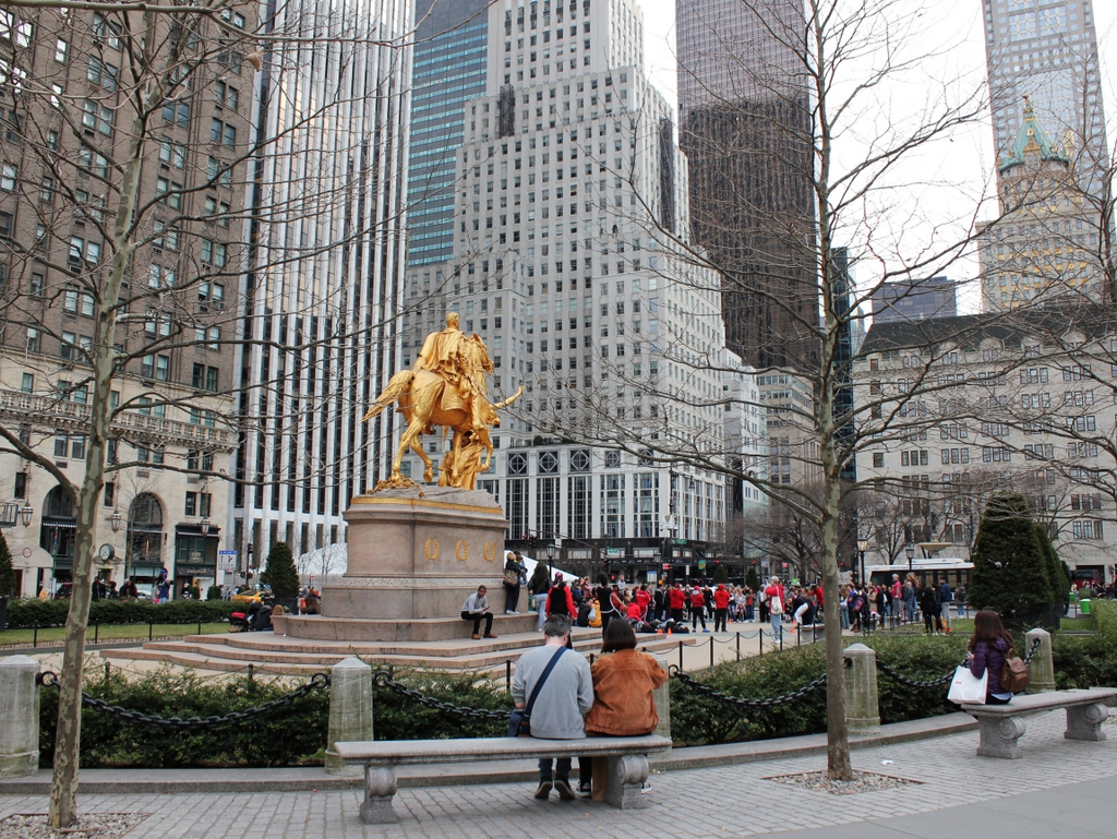
These photos show the view looking down Fifth Avenue from what is now Grand Army Plaza, at the southeast corner of Central Park. The first one was taken around 1904, at a time when this section of Fifth Avenue was undergoing a transition from an affluent residential neighborhood to a busy commercial center. As a result, the photo shows a mix of both private homes and turn-of-the-century skyscrapers along this part of the street.

The most dominant feature in the foreground of this scene is the statue William Tecumseh Sherman, which was installed in 1903. It was designed by prominent sculptor Augustus Saint-Gaudens, and it commemorates the famous Civil War general who spent his later years in New York City. Beyond the monument, on the far left side of the photo, is the Hotel Netherland, which was built in 1893 at the northeast corner of Fifth Avenue and East 59th Street. To the right of it is the Hotel Savoy, which was built in 1892, and further to the right, in the center of the scene, is the much smaller Bolkenhayn apartment building. This was also built around the same time, and one of its early guests was a young Winston Churchill, who stayed here in the apartment of Congressman William Bourke Cockran during a visit to New York in 1895.

To the right of the Bolkenhayn, on the block between East 57th and East 58th Streets, is Marble Row. This block of eight marble townhouses was built in 1869, and over the years it was home to a number of wealthy residents. Mary Mason Jones, daughter of the noted early 19th century businessman John Mason, originally owned all eight homes, and she lived in the southernmost one, at the corner of East 57th Street on the right side of the building. This house was later the home of businessman Hermann Oelrichs and his wife Theresa, who also owned the famous Rosecliff mansion in Newport. Other wealthy residents of the townhouses included merchant William E. Iselin and businessman Solomon R. Guggenheim, the founder of the Guggenheim Museum in New York. Many of these homes were still private residences when the first photo was taken, but at least one—the one on the left side of the building at the corner of East 58th Street—had been converted to commercial use, having been occupied by the Plaza Bank since the early 1890s.

Beyond Marble Row are more upscale 19th century homes. On the other side of East 57th Street is the home of Collis P. Huntington, a railroad executive who was involved in the construction of the First Transcontinental Railroad as part of the Central Pacific Railroad. He built this granite house in the early 1890s, and he died in 1900, although his widow Arabella was still living here when the first photo was taken. There are more homes further in the distance past this house, but they are dwarfed by the 20-story St. Regis Hotel, which was completed in 1904 at the corner of Fifth Avenue and East 55th Street.

On the far right side of the first photo is the home of Cornelius Vanderbilt II. The original portion of this house was built in 1883, at the corner of West 57th Street, but a decade later it was expanded along the entire length of the block to West 58th Street, making it the largest private home ever built in New York City. Vanderbilt was the grandson of family patriarch Cornelius Vanderbilt, and he was also the largest beneficiary of the family fortune upon the death of his father in 1885, receiving nearly $70 million. He spent a good portion of his wealth on lavish homes, including this one in New York and The Breakers in Newport. He died in 1899, but his widow Alice continued to live in these houses for several more decades.

Today, more than a century later, there is almost nothing left here from the first photo, aside from the Sherman statue in the foreground. The Hotel Netherland was demolished in 1926, and a year later it was replaced by the Sherry-Netherland, which still stands on the site. Also during the mid-1920s, the neighboring Hotel Savoy and the Bolkenhayn were demolished, after having been acquired by the owner of the nearby Plaza Hotel. The site was rebuilt with a new hotel, the Savoy-Plaza Hotel, which opened in 1927. This building was, in turn, demolished in 1965 to build the 50-story General Motors Building, visible just to the left of the statue in the present-day photo.

Further in the distance, the townhouses of Marble Row were demolished piecemeal during the early 20th century. The last surviving remnant, the corner house on the right side, stood here until around 1930, and today the majority of this block is occupied by the Art Deco-style Squibb Building, built in 1930 at 745 Fifth Avenue. Both the Huntington and Vanderbilt mansions were similarly demolished in the late 1920s, and their lost are now home to the flagship stores of Tiffany & Co. and Bergdorf Goodman, respectively. Further down Fifth Avenue, the other 19th century mansions from the first photo are also long gone, and much of this land is now the site of the 58-story Trump Tower, visible in the center-right of the present-day photo. Overall, the only surviving building from the first photo is the St. Regis. However, while it was very prominent in that photo, it is now hidden from view in this scene by the modern skyscrapers that surround it.

Forest Park Lily Ponds, Springfield, Mass

The lily ponds in Forest Park in Springfield, around 1907. Image courtesy of the Library of Congress, Detroit Publishing Company Collection.

The scene in 2018:

Forest Park is the largest public park in Springfield, encompassing 735 acres of land in the southwestern corner of the city. The origins of the park date back to 1884, and over the years it has been steadily expanded through various donations and land purchases. One of the most significant of these donors was Everett H. Barney, a local ice skate manufacturer who owned much of what is now the western section of the park. He built his house, Pecousic Villa, on the property in 1883, and he subsequently landscaped the grounds with ponds, fountains, a waterfall, bridges, and a network of paths.

Barney had intended to construct a house here for his only child, George. However, George died in 1889, and Barney instead built a mausoleum for his son on the site of what would have been his house. With no other heirs, Barney donated his entire estate to the city, including the house and the meticulously-maintained grounds. His only stipulation was that he and his wife Eliza would be able to reside in the house for the rest of their lives, and they went on to live here until her death in 1905 and his in 1916.

The first photo was taken sometime around 1907, showing the lily ponds that Barney had constructed. It was taken from the path between the lily ponds and the Pecousic Brook, and the view faces north, with Pecousic Villa just out of view on the far left side, on the other side of the hill. Unlike the other sections of Forest Park, which were left in more or less a natural state, this scene was mostly artificial, and the plan was not necessarily admired by all. For example, in 1901 the Springfield Republican published a lengthy commentary on the park, in which it lamented that “Not all the changes of recent years have been for the better.” The article went on to explain:

Everyone must admire the enthusiasm with which Mr. Barney has cultivated the extensive grounds which he has generously added to the park, and criticism of the results would be a most ungrateful task, yet it must be clear from the principles which have been indicated, that a somewhat difficult problem is raised by the conflicting ideals which have been pursued. The rare beauty of the lotus and lily ponds is undeniable, but the general scheme of the park and that of Mr. Barney’s very valuable addition are incongruous. In the park the effort has been to keep as much of nature as is possible in a city park. Mr. Barney’s plan, carried out with diligent personal attention through many years, has involved a design which, though not conventional, is at least artificial.

This criticism notwithstanding, Forest Park proved to be a popular recreation area, with most visitors evidently remaining unfazed by the inconsistencies between the more natural eastern half of the park and the carefully-manicured areas here in the western half. One of the city’s other newspapers, the Springfield Union, praised Barney for his landscaping work in his obituary in 1916, writing:

Forest Park is Springfield’s great breathing ground, and a trip there always includes a visit to “Barney’s front yard.” There he showed his passionate love for nature and that he was an expert horticulturalist. He planted there rare shrubs and trees from Europe, Egypt, China, Japan and India, and there he planned and maintained lily ponds containing nearly all varieties of lilies. There, too, he maintained a lotus pond. Mr. Barney’s nature was a restless, untiring one, and he changed his lawns and flower gardens frequently. His taste ran strongly to mathematical arrangement of flower beds and shrubs, and one is constantly startled by coming suddenly on a stone deer or other piece of statuary.

Today, more than a century after the first photo was taken, Forest Park has undergone some significant changes, including the demolition of the Barney house in the late 1950s to make way for Interstate 91. However, many other scenes in the park, including this one, have remained largely the same. Forest Park is actually much more forested now than it was when it acquired its name, and there are far more trees in the present-day photo, including in the foreground and on the distant hillside. Overall, though, Barney’s lily ponds still look as they did when he first laid them out in the late 19th century, and much of his other landscaping work remains intact after having been enjoyed by many generations of Springfield residents.


Willey House, Hart’s Location, New Hampshire (3)

The view looking north in Crawford Notch in the White Mountains, with the Willey House in the distance on the left, around the 1860s or 1870s. Image courtesy of the New York Public Library.

The scene in 2018:

These photos show the view looking north in Crawford Notch, a long, narrow valley through the heart of the White Mountains. For many years, it was the only east-west route through the mountain range, and since the late 18th century it has been a vital transportation corridor. As explained in more detail in an earlier post, the first road through the notch was opened in 1774, and over the years it was steadily improved, eventually becoming part of the Tenth New Hampshire Turnpike in 1806.

To serve these travelers in the midst of the northern New Hampshire wilderness, a series of inns were opened in and around the notch. The first building within the notch itself was a house that was constructed in 1793. Later known as the Willey House, it stood in the left-center of the first photo, where the peak of its gabled roof is barely visible beyond a much larger three-story hotel that was constructed in 1845.

The house served as both a residence and a small inn, and it had several different owners in the early 19th century before being acquired by Samuel Willey in 1825. It was an isolated location in the middle of the notch, several miles away from the nearest neighbor, but Willey moved here in the fall of 1825, along with his wife Polly and their five young children. He spent much of the fall improving the property and preparing it for the long, cold northern New England winter, and the result was a modest but comfortable place for travelers to stop for food, drink, or shelter.

As the Willeys would soon discover, though, the house’s location at the base of a steep cliff made it susceptible to landslides. One occurred in June 1826, and it narrowly missed the house. Then, two months later, another one occurred during a heavy rainstorm on the night of August 28. This time, the house was completely encircled by the debris, although the house itself survived unscathed thanks to a low ledge just above it, which split the flow into two channels.

Unfortunately, though, the Willey family attempted to flee the house in the midst of the storm, evidently fearing that the house would be destroyed. However, in the darkness they unknowingly ran directly into the path of the slide, and all seven were killed, along with two hired hands who lived here with them. Searchers subsequently found six of the bodies, some of them badly mangled, but three of the Willey children were never recovered.

The sudden deaths of nine people, more than half of whom were children under the age of 13, quickly gained national attention. This helped to spur tourism to the White Mountains, and over the next few years many curious visitors came to Crawford Notch to see the Willey House, the aftermath of the landslide, and the surrounding wilderness. The story also became the subject of a now-lost painting by noted artist Thomas Cole, and a short story, “The Ambitious Guest,” by Nathaniel Hawthorne.

By the mid-19th century, the area was a popular destination thanks in large part to the publicity generated by the Willey disaster, and there were many hotels in the vicinity of Crawford Notch. These included the Willey House itself, which had been purchased by Horace Fabyan in 1845. He constructed a new, much larger hotel building adjacent to the old house, and it can be seen on the left side of the first photo. Both buildings stood here until nearly the end of the 19th century, but they were ultimately destroyed by a fire in September 1899.

Today, the site of the house and hotel is now the visitor center and park headquarters for the Crawford Notch State Park. There is little evidence of the buildings that once stood here, although the location of the Willey House is now marked by a small stone monument. The road has also changed significantly since the first photo was taken some 150 years ago, and the narrow dirt path is now U.S. Route 302. Overall, the only thing from the first photo that has not changed is the surrounding landscape, which has been preserved as part of the state park. This includes the most prominent feature in both photos, the 2,804-foot Mount Willard, which dominates the background of the scene and marks the northern end of Crawford Notch.

Crawford House, Carroll, New Hampshire

The Crawford House at Crawford Notch in the White Mountains of New Hampshire, seen from across Saco Lake, around 1891-1910. Image courtesy of the Library of Congress, Detroit Publishing Company Collection.

The scene in 2018:

The first photo shows the Crawford House, one of the many large hotels that were built in the White Mountains during the second half of the 19th century. It stood just to the north of the gates of Crawford Notch, one of the most important mountain passes in the region. The location of the hotel was near the high point of the notch, at the divide that separates the watersheds of the Ammonoosuc and Saco Rivers. In the foreground of this scene is Saco Lake, which forms the headwaters of the Saco River. From here, the river flows southeast through Crawford Notch before emptying into the Atlantic Ocean just south of Portland, Maine. Less than a half mile to the north of here, on the other side of the hotel, is Ammonoosuc Lake, which ultimately drains into the Connecticut River and then to Long Island Sound.

This site was an ideal location for a hotel. At the time, this road was the only east-west route through the mountains, and this area to the north of Crawford Notch was relatively broad and flat, unlike the long, narrow valley to the south of here. The first hotel in this immediate vicinity was the Notch House, which was built in 1828 by Ethan Allen Crawford. He was the son of Abel Crawford, the first white settler to live near the notch, and his family operated several taverns in the area. Ethan’s brother Thomas became the manager here at the Notch House, and he ran it until 1852, two years before it was destroyed by a fire.

The Notch House was located near the spot where these two photos were taken, but around 1850 Thomas Crawford began construction of a new hotel nearby, on the site of the hotel in the first photo. However, he ran into financial problems before it was completed, and he had to sell the property in the early 1850s. The new owner finished the hotel, which became known as the Crawford House, but, like the Notch House, it fell victim to fire, burning on April 30, 1859.

Such fires were not uncommon in large resort hotels of this period, which were generally made almost entirely of wood and lacked effective fire suppression systems. Despite this setback, though, the hotel was quickly rebuilt. The work began on May 10, 1859 and it was completed in just two months, with the hotel holding a celebratory dinner here on July 13. This new Crawford House, which was still standing when the first photo was taken, was three stories high and originally measured about 200 feet in length, with two wings that extended back about the same distance. Overall, it was much larger than the old building on the site, and a July 1859 article in the Boston Evening Transcript declared it to be the largest hotel in the state.

Another New England newspaper, the Independent Democrat of Concord, New Hampshire, published a letter around the same time that the hotel opened. The letter described a journey through the White Mountains, and it paid particular attention to the new Crawford House. The writer commented on how quickly the hotel was built, and also provided a glowing description of its interior, writing:

It is not too much to say that the “New Crawford house” is an advance upon any other at the Mountains. Its dining hall is of magnificent proportions, measuring 85 feet by 40, and 14 feet high. The principal parlor is 60 feet by 40. The general reception room is large and airy; while the sleeping rooms, of which there are some 120, are large, high, and thoroughly ventilated, leaving nothing, in these respects, to be desired. Then, the whole house is to be furnished in the most elegant and substantial style, and the whole is to be lighted with gas.

Guests at the Crawford House could enjoy a variety of outdoor activities. There were short hikes to places such as Ripley Falls, Arethusa Falls, and the summit of nearby Mount Willard, and for the more ambitious there was the Crawford Path, which led 8.5 miles to the summit of Mount Washington. This trail, which began here at the Crawford House, was created by Abel and Ethan Crawford in 1819, and it was eventually incorporated into the Appalachian Trail, making it probably the oldest active hiking trail in the country today. Guests could hike these trails on their own, but the hotel also had ponies that they could ride, along with experienced guides to accompany them.

In 1870, the Crawford House was purchased by brothers Asa T. and Oscar F. Barron. At the time, they also operated the nearby Twin Mountain House and Fabyan House, and their hotel empire would subsequently include the Mount Pleasant House and the Summit House, which was located at the top of Mount Washington. Oscar died here at the Crawford House in 1879, and Asa died eight years later, but the Barron family would continue to run these hotels for many years.

For the first two decades of its existence, the Crawford House was not directly served by railroads, but in 1875 the Portland & Ogdensburg Railroad opened through Crawford Notch, making the hotel far more accessible to visitors. At the time, it was the only hotel in the vicinity of the notch, and it received a glowing review in the 1887 Chisholm’s White-Mountain Guide-Book, which included the following description:

[T]his is a good hotel of the first class, 1,900 feet above the sea, with broad and almost interminable piazzas, cool and airy halls, post-office, telegraph-office, livery-stable, bowling-alley, gaslights; environs which the landscape-gardener has justly approved; and a dining-room where even Epicurus or Uncle Sam Ward need not famish….

Near the front of the house is the pretty little Saco Lake, the cradle of the Saco River, and so far widened and deepened by art as to give a reason for being for the boats which float on its crystal tide. The rugged forest between the lake and the overhanging mountain has been combed and brushed and perfumed, and otherwise adorned for a summer pleasaunce, so that it has won the happily suggestive name of Idlewild.

In 1888, not long after this description was published, the rail line through the notch was acquired by the Maine Central Railroad. Three years later, the railroad built a new station here at the Crawford House, which is visible on the left side of this scene. It was built of wood, and it featured an ornate Queen Anne-style design, complete with a small tower on one corner of the building. Most hotel guests and other visitors to Crawford Notch would have arrived here by way of the station, and the building also served as the local freight house and post office.

By the time the first photo was taken at the turn of the 20th century, the Crawford House was owned by the firm of Barron, Merrill, & Barron. This partnership was comprised of Asa Barron’s sons, Oscar G. and William A. Barron, along with Cardenio H. Merrill, and the trio also ran the other Barron hotels here in the White Mountains. Merrill died a few years later in 1908 at the age of 68, and Oscar in 1913 at 62, but William continued to operate the hotel until 1947, when he retired and sold the property. He died in 1964 at the age of 96, only a week after the death of his son, William A. Barron Jr., who had served as a brigadier general in the Army during World War II and as chairman of the board of Gillette after the war.

The Crawford House outlasted most of the other 19th century grand hotels in the White Mountains, but it ultimately closed in 1975, nearly 120 years after the building was constructed. It was destroyed by a fire two years later, on November 20, 1977, and the property was subsequently acquired by the Appalachian Mountain Club, which constructed the Highland Center on the site. This building, which serves as a lodge and an educational center, stands in the center of the 2018 photo. Today, the only surviving building from the first photo is the railroad station on the left. It was added to the National Register of Historic Places in 1982, and it remains in use as a railroad station, serving as the northern terminus for most tourist excursion trains on the Conway Scenic Railroad.

Crawford Notch, Hart’s Location, New Hampshire (2)

The view looking north through Crawford Notch in the White Mountains of New Hampshire, around 1900. Image courtesy of the Library of Congress, Detroit Publishing Company Collection.

The scene in 2018:

As discussed in greater detail in the previous post, Crawford Notch is one of the major mountain passes through the White Mountains region. It was first discovered by European settlers in 1771, and a road was built through here a few years later. However, the notch was already known to Native Americans long before then, and they had a trail that passed through here.

Crawford Notch is several miles in length, consisting of a narrow valley through the mountains, but its narrowest point is here at the northern end of the valley, near the divide between the watersheds of the Ammonoosuc and Saco Rivers. This spot, with steep rock ledges on either side, became known as the gates of the notch, and it was originally just a little over 20 feet in width. Over the years, though, it has been steadily widened, as a result of improvements to the road and the construction of a railroad through here in 1875.

The first photo was taken around the turn of the 20th century, at the start of the automobile era, but the road through the notch still looked very primitive at the time. Despite its appearance, though, this road served as a vital corridor through the mountains. Prior to the construction of the Kancamagus Highway in the 1960s, it was the only east-west road in the White Mountains, linking northern Vermont with the coastal region of southern Maine.

In addition, Crawford Notch also provided tourists with access to the White Mountains region, and many began arriving here during the first half of the 19th century. In fact, the notch itself is named for the Crawford family, who ran several different hotels in the vicinity of Crawford Notch during this period. They also blazed a trail, later known as the Crawford Path, from the notch to the summit of Mount Washington, and provided guided tours for visitors. This trail is still in use today, as the oldest segment of the modern-day Appalachian Trail.

Probably the most famous hotel here at the notch was the Crawford House, which is visible in the distance of the first photo. This property had previously been owned by the Crawford family, and in 1850 Tom Crawford began construction on the hotel. However, he soon ran into financial problems, and he had to sell the unfinished hotel. It was subsequently completed by a different owner, although the building was destroyed by a fire only a few years later, in 1859. The Crawford House was rebuilt later in 1859, though, and this second hotel building was still standing when the first photo was taken.

Today, more than a century after the first photo, Crawford Notch remains an important route through the mountains, although this scene here at the gates of the notch has undergone some significant changes. The narrow road from the first photo, with its wagon tracks visible in the dirt, is now the much wider U.S. Route 302. Further in the distance, the Crawford House is gone. It stood here for many years, but the hotel ultimately closed in 1975 and the building burned two years later. The site of the hotel is now the Highland Center, a lodge and educational center that is run by the Appalachian Mountain Club. The only surviving building from the first photo is the railroad station, which is barely visible in front of the left side of the hotel. It was built in 1891, and today it is still in use, serving as the northern terminus for most trains on the Conway Scenic Railroad.

Crawford Notch, Hart’s Location, New Hampshire

The view looking northwest through Crawford Notch in the White Mountains of New Hampshire, around 1860-1875. Image courtesy of the New York Public Library.

The same view around 1907. Image courtesy of the Library of Congress, Detroit Publishing Company Collection.

The scene in 2018:

Crawford Notch is an important mountain pass within the White Mountains of New Hampshire. Until the completion of the Kancamagus Highway in the 1960s, it was the only east-west route through the mountain range, and over the years it has served as a major link between northern Vermont and the coastal region of southern Maine. The notch consists of a narrow valley that is several miles in length, but the actual mountain pass is here at the northern end of this valley, at a gap in the mountains that was originally barely 20 feet wide. This spot came to be known as the gate of the notch, because of the high rocks that stand on either side of the pass.

The highest point of Crawford Notch is just to the north beyond the gates, in the distance of this scene. At 1,900 feet in elevation, it forms the divide between the Ammonoosuc River, which flows west to the Connecticut River and then to Long Island Sound, and the Saco River, which flows east through Crawford Notch and then to Maine, where it empties into the Atlantic Ocean just south of Portland. To the northeast of here is the Presidential Range, which begins here at the Notch and reaches its highest point, Mount Washington, about 6.5 miles from here. In the opposite direction, to the southwest of the notch, is the Peimgewasset Wilderness, the largest wilderness area in the state.

The first recorded discovery of Crawford Notch occurred in 1771, when Timothy Nash and Benjamin Sawyer came across it while hunting. As the story goes, Nash had become lost while tracking a moose. He climbed a tree in order to get his bearings, and in the process he sighted the gates here at the northern end of the notch. The notch had long been known to Native Americans, but Nash and Sawyer were evidently the first Europeans to find it, and within a few years there was a rough road through here.

The notch was ultimately named in honor of the Crawford family, who became the first permanent settlers of the area. Around 1790, Abel Crawford built a house a little further to the north of here, where he remained for several years before selling it to his father-in-law, Eleazer Rosebrook. Crawford then moved to the southern end of the notch, around the site of the present-day town of Hart’s Location.

Both he and Rosebrook operated inns for travelers, and Crawford helped to pioneer tourism to the White Mountains region. After Rosebrook’s death in 1817, Abel’s son Ethan Allen Crawford inherited the property here at the notch. Two years later, the Crawfords constructed an 8.5-mile trail from the notch to the summit of Mount Washington, and provided guided trips for visitors. Now known as the Crawford Path, it is considered to be the oldest continuously-used hiking trail in the country, and it has been incorporated into the Appalachian Trail.

One early visitor to this region was Timothy Dwight IV, a prominent author and theologian who served as president of Yale from 1795 to 1817. He came to the Notch on at least two separate occasions, and provided a description of it in his book Travels in New England and New York. In this particular visit, he approached the notch from the north, facing the opposite direction of these photos, and he wrote:

The entrance of the chasm is formed by two rocks, standing perpendicularly at the distance of twenty-two feet from each other: one about twenty feet in height, the other about twelve. Half of the space is occupied by the brook, mentioned as the head stream of the Saco; the other half by the road. The stream is lost, and invisible, beneath a mass of fragments, partly blown out of the road, and partly thrown down by some great convulsion.

When we entered the Notch we were struck with the wild and solemn appearance of every thing before us. The scale, on which all objects in view were formed, was the scale of grandeur only. The rocks, rude and ragged in a manner rarely paralleled, were fashioned and piled on each other by a hand, operating only in the boldest and most irregular manner. As we advanced, these appearances increased rapidly. Huge masses of granite, of every abrupt form, and hoary with a moss which seemed a product of ages, recalling to the mind the “Saxum vetustum” of Virgil, speedily rose to a mountainous height. Before us, the view widened fast to the south-east. Behind us, it closed almost instantaneously; and presented nothing to the eye but an impassable barrier of mountains.

The first photo was taken more than a half century after Dwight wrote this account, but the notch still had much of the same rugged appearance that he would have seen. The road had been improved somewhat over the years, starting in 1806, when the Tenth New Hampshire Turnpike opened through the notch. By the late 1820s, the road was suitable for stagecoaches, but when the first photo was taken around the 1860s or 1870s, this section of the road still looked like a narrow dirt path through the wilderness.

Aside from the road, the only sign of civilization in the first photo is the Crawford House, which is barely visible in the distant center. The original Crawford House was built here in the early 1850s, but it burned in 1859. The hotel was quickly rebuilt on the same site, reopening later in 1859. This new building can be seen in both the first and second photos, and it stood here until it too was destroyed by a fire in 1977. The site of the hotel is now the Highland Center, a lodge and education center operated by the Appalachian Mountain Club.

Perhaps the most dramatic change in this scene occurred shortly after the first photo was taken, when a railroad was constructed through here. The first railroad across the continent had been completed in 1869, and by this point there was even a cog railway to the summit of nearby Mount Washington. However, it would take several more years for railroad engineers to conquer Crawford Notch. The project required several long trestles and deep rock cuts, along with the widening of the gap here at the gates of the notch. The grade of the railroad was also a challenge, with northbound trains having to ascend 1,623 feet in just 30 miles, but the Portland & Ogdensburg Railroad was ultimately completed through the notch in 1875.

In addition to improving transportation through northern New England, the railroad also provided passenger service to the heart of the White Mountains, making it easier for tourists to visit the region. Several of the grand hotels along the route even had their own stations, including the Crawford House, whose station is barely visible in the distance on the right side of the tracks in the second photo. This particular station building had been constructed in 1891, several years after the Maine Central Railroad acquired the Portland & Ogdensburg, and it is still standing today as the only surviving structure from the second photo.

In more than a century since the second photo was taken, the road through the notch has been widened and straightened. It has come a long way since the dirt path of the first photo, and it is now designated as U.S. Route 302, which runs from Portland, Maine to Montpelier, Vermont. Today, it remains as important a route through the White Mountains as it had been when the first road was constructed through here in the 18th century. In that sense, the road has actually outlived the railroad, which was abandoned by Maine Central’s successors, Guilford Transportation, in 1983. However, this section of railroad was ultimately acquired by the Conway Scenic Railroad, which operates excursion trains for tourists. The railroad also owns the station here in the distance, and it serves as the northern terminus for most of its trains.

Today, the White Mountains are still a popular tourist destination, and Crawford Notch is still a major focal point within the region. Most of the notch is within the town of Hart’s Location (population 41 as of 2010), but the northern border of the town is here at the gates of the notch, so the buildings in the distance are actually within the town of Carroll. The land on the Carroll side of the border is still privately owned, but the Hart’s Location side is part of the 5,775-acre Crawford Notch State Park. This park is, in turn, mostly surrounded by the much larger White Mountains National Forest, which covers more than 750,000 acres in New Hampshire and Maine.