Crawford Street Bridge, Providence, RI

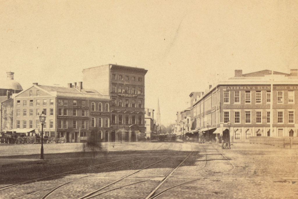
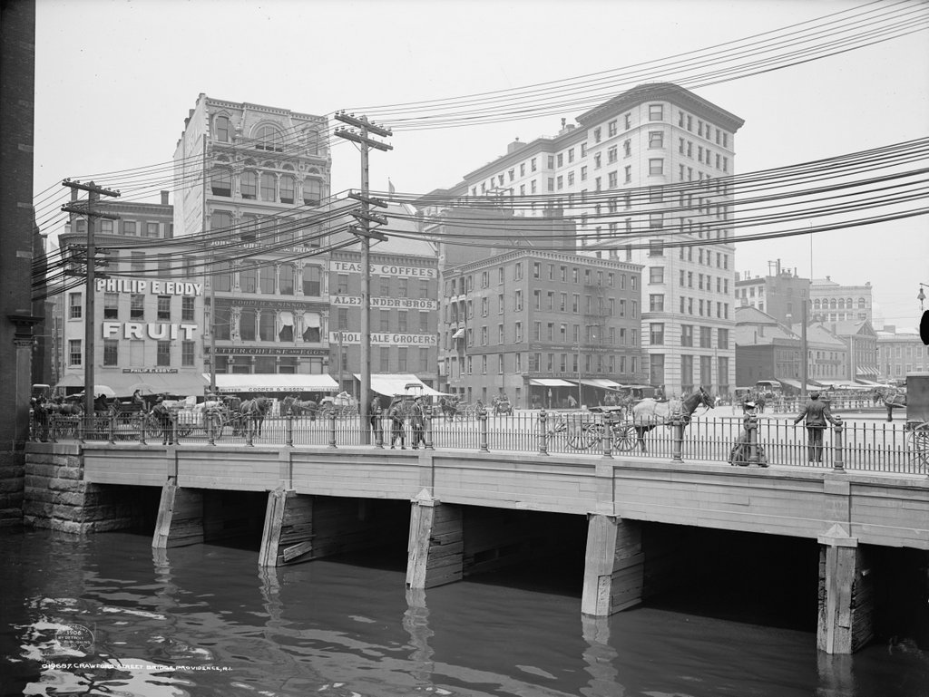
Looking across the Providence River toward downtown Providence, with the Crawford Street Bridge in the foreground, around 1906. Image courtesy of the Library of Congress, Detroit Publishing Company Collection.
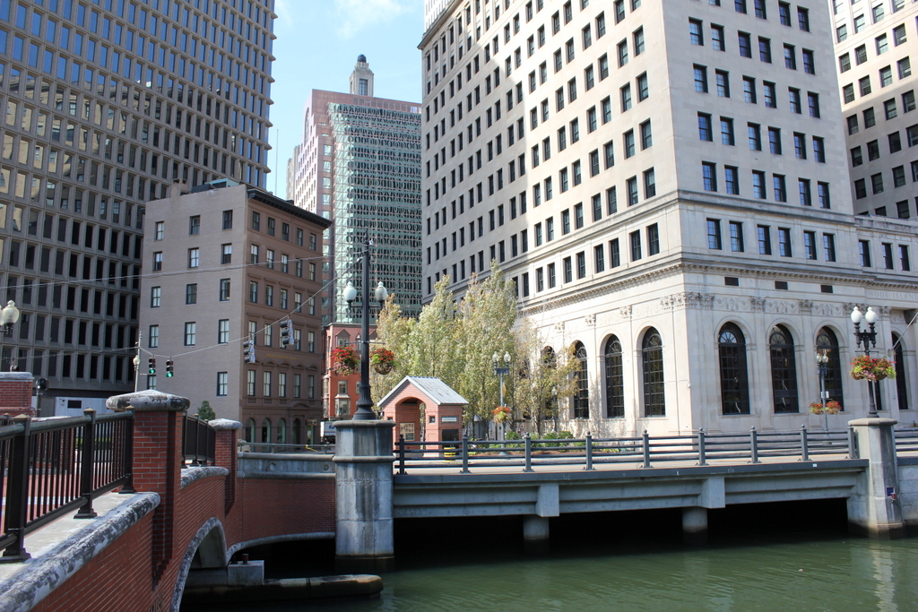
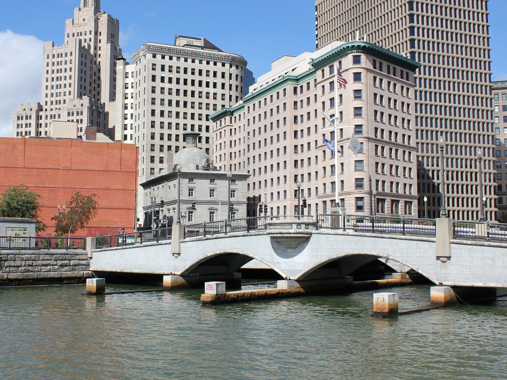
1061_1906c-loc

The scene in 2016:

1061_2016
This is probably one of the rare instances when the “now” photo of a city actually looks better than the “then” photo. The first shows a growing city with a mix of new and old buildings, with a skyline that is marred by overhead wires in the foreground. The Providence River was little more than an open sewer, carrying human waste as well as industrial pollution from factories further upstream. By the early 20th century, the river was largely covered by the Crawford Street Bridge, whose southern end is visible in this photo. It eventually earned a spot in the Guinness Book of World Records as the world’s widest bridge, extending upstream for about 1,150 feet, or nearly a quarter mile. This bridge largely hid the river from view in downtown Providence, which was probably all well and good considering that the smell of sewage in the river reportedly caused some people – perhaps Victorian women in tightly-laced corsets – to faint from it.

Most of the buildings in the first photo date to the mid-19th century, but perhaps the newest at the time was the Banigan Building, the tall building on the right side of the photo. It was built in 1896 as the city’s first skyscraper, and was owned by and named for businessman Joseph Banigan. Born to a poor family in Ireland in 1839, Banigan and his family came to the United States in the 1840s during the Potato Famine. Here, he became the archetypical rags-to-riches 19th century industrialist, eventually owning a successful rubber company along with other business interests, including this building.

The Banigan Building is still standing in the present-day scene, and it is joined by several other historic buildings. Just to the left of it is the old Customshouse, which was completed in 1857. It was obviously there when the first photo was taken, but was hidden by other buildings at the time. Two taller historic skyscrapers stand just beyond the Customshouse. Immediately behind it is the Turk’s Head Building, which was the tallest skyscraper in the city when completed in 1913, and to the left is the Bank of America Building. This Art Deco skyscraper was completed in 1928, and at 428 feet high it has been the tallest building in Rhode Island ever since.

Aside from the skyline, the most significant change to this scene has been the Providence River itself. The massive Crawford Street Bridge, its world record notwithstanding, was demolished in the late 1980s, reintroducing the city to the long-hidden river as part of an urban revitalization project. Today, the river is spanned by a series of smaller, more ornate bridges. The river itself is much cleaner than it was a century ago, and now offers gondola rides along with being the focal point of Providence’s regular WaterFire events.

Westminster Street, Providence, RI

Looking southwest on Westminster Street from the bridge over the Providence River, in 1865. Image courtesy of the New York Public Library.

1060_1865-nypl

The scene in 2016:

1060_2016
One of the main commercial streets in downtown Providence is Westminster Street, which begins here at the College Street Bridge and continues southwest through downtown Providence and toward the Federal Hill neighborhood. When the first photo was taken, this area consisted primarily of low-rise brick commercial buildings, some of which dated as far back as the early 19th century. The oldest was probably the Union Bank Building on the left, which dated back to 1816. Just to the right of it is Merchants Bank Building, completed in 1857, and on the other side of Westminster Street is part of the large Washington Building, which was built in 1843. Also partially visible in this scene is the 1857 Customhouse, whose dome can be seen in the distance on the far left.

Today, this streetscape has completely changed. Only the Merchants Bank Building remains, now seeming oddly out of place. It has actually gained an additional floor in the intervening years, but despite this it is still completely dwarfed by modern skyscrapers, being literally overshadowed by its neighbor to the left. The Union Bank Building is long gone, as is the Washington Building, which died a slow death in the late 19th and early 20th centuries. It was partially demolished around 1889 to build a Romanesque building for the Rhode Island Hospital Trust Company. Both this new structure and the remainders of the old one were demolished by 1919, when a new, much larger building was completed for the company on the same site. This building is still standing, dominating the right side of the 2016 photo, but it is now owned by the Rhode Island School of Design as part of their campus. The only other survivor from the first photo is the Customhouse building. It is hidden behind modern buildings, but is still standing on Weybosset Street and is in use as a courthouse.

Rhode Island Normal School, Providence, RI

The Rhode Island Normal School, seen from Francis Street in Providence, around 1906. Image courtesy of the Library of Congress, Detroit Publishing Company Collection.

1059_1906c-loc

The scene in 2016:

1059_2016
The building in the first photo was once the home of the Rhode Island Normal School, a teacher preparatory college that has since become Rhode Island College. The school was established in 1854, and was housed in several different buildings in the city until 1898, when the building in the first photo opened. Here, it enjoyed a prominent location just south of the Rhode Island State House, with a large lawn on the Francis Street side of the building.

During its time here, the school steadily grew. In 1920, it became the Rhode Island College of Education, offering bachelor’s and master’s degrees for the first time. By the 1950s, though, there were talks of merging the school into the University of Rhode Island. However, the school remained independent, and in 1958 they moved to a new campus in the outskirts of the city. A year later, with the school expanding beyond just education degrees, the name was changed to simply Rhode Island College.

After the college moved to its current campus, the old 1898 building remained here in downtown Providence for many more years. It was finally demolished in the late 1990s to build Providence Place, the large shopping mall that stands on the site today. I don’t known whether it was deliberate or not, but the Nordstrom section of the building appears to pay homage to the design of the old Normal School, with its yellow brick exterior and the similar-looking cornice with dentils at the top of the building.

Rhode Island State House, Providence, RI

The south side of the Rhode Island State House in Providence, around 1906. Image courtesy of the Library of Congress, Detroit Publishing Company Collection.

1058_1906c-loc

The scene in 2016:

1058_2016
Rhode Island is known for having the smallest land area of any US state, but despite its diminutive size, it had an unusual state capital arrangement for many years, with the legislature alternating sessions between the five county courthouses, effectively giving the state five capital cities. While much larger states managed to make do with just one capital city, this practice continued until 1854, when the rotation was reduced to just two, Providence and Newport. Having joint capitals was not unique to Rhode Island – neighboring Connecticut did the same for many years – but Rhode Island continued the practice until 1900.

At this point, when the legislature was in Providence, they were still meeting in the small colonial-era courthouse on Benefit Street. It hardly compared to the far grander capitol buildings other New England states such as Connecticut and Massachusetts, so in 1895 construction began on the present-day Rhode Island State House. It was built on Smith Hill, a hill that overlooks downtown Providence on the other side of the Woonasquatucket River. Its architecture resembles the US Capitol Building, with wings on either side for the two legislative houses and a large rotunda in the center, and it was designed by the prominent firm of McKim, Mead and White in their distinctive Classical Revival style.

The Rhode Island legislature began meeting in the new building in 1901, although it was not completed until 1904, after nearly a decade of construction. Today, the area around the State House has seen some dramatic changes. Interstate 95 now passes just west of here, and just to the east is the Northeast Corridor, the busiest passenger rail line in the country. To the southwest is Providence Place, a large shopping mall with adjacent parking garages. However, here on the State House grounds, very little has changed. The grounds retain a park-like atmosphere, and the historic building itself is still the seat of Rhode Island’s state government.

View from Citadel Hill, Halifax, Nova Scotia

The view looking east toward downtown Halifax from Citadel Hill, around 1900-1917. Image courtesy of the Library of Congress.

1056_1900-1917c-loc

The view in 2016:

1056_2016
It isn’t in New England, or even in the United States, but Halifax has long had close ties with New England, especially Boston. It is the closest major North American port to Europe, and as such it is the last stop for outgoing ships from Boston, and the first for incoming ships. This scene here shows part of the city’s massive harbor, which has been of strategic importance over the years. After the British occupation of Boston ended in 1776, their fleet took refuge here in Halifax while preparing for an assault on New York City, and many years later the harbor was used as a gathering place for eastbound Atlantic convoys in both world wars.

Through all of this, the strategically-valuable harbor has been protected by Fort George, a series of fortifications atop Citadel Hill. The hill stands just west of downtown Halifax, offering sweeping views of the city and harbor, and making it the ideal location for a fort to command the harbor and its approaches. The photos here were taken near the top of the hill, near the outer walls of the fort. On the left is one of Halifax’s oldest landmarks, the Town Clock, which was built at the foot of the hill. It faces down Carmichael Street, which leads to the Grand Parade three blocks down the hill, where City Hall and St. Paul’s Anglican Church are located.

The date of the first photo is somewhat unclear, but it was taken sometime soon before 1917, when Halifax experienced one of the deadliest disasters in history. Known as the Halifax Explosion, it occurred on December 6, 1917, when the harbor was filled with ships heading to and from Europe during World War I. Two such ships were the Norwegian SS Imo, which collided with French ammunition ship SS Mont-Blanc. The latter caught fire, and after about 20 minutes its cargo of high explosives detonated.

The Mont-Blanc was essentially vaporized, and the blast wave leveled much of the northern part of the city, to the left and out of view in the photos here. A few earlier posts, here and here, show scenes from the aftermath of the explosion, which killed nearly 2,000 people, injured around 9,000 others, and damaged or destroyed around 12,000 houses. The main commercial center of Halifax, seen in this view from Citadel Hill, escaped serious damage. Essentially every window in the city was shattered by the explosion, but most of the buildings in the first photo would have survived the disaster.

Despite being spared from serious damage, there is very little that is still recognizable from the first photo a century later. There are a number of 19th century buildings scattered throughout this section of the city, but the only one that is readily visible in both photos is the clock tower itself, which remains a prominent city landmark.

Today, Halifax remains an important port. It is the largest city in Canada’s Maritime provinces, and its downtown has been built up with skyscrapers, partially obscuring the view of the harbor from Citadel Hill. The shoreline across the harbor in Dartmouth has also changed dramatically in the past 100 years. In 1911, the community had a population of just over 5,000, but today it has over 67,000 people, and is a major suburb of Halifax as well as a commercial center in its own right.

First Congregational Church, West Springfield, Mass

The First Congregational Church on Park Street in West Springfield, around 1912. Image from Picturesque Springfield and West Springfield (1912).

1055_1912c-picturesquespfld

The church in 2016:

1055_2016
In the 18th and early 19th centuries, few issues caused as much controversy in some New England towns as the location of the meetinghouse. West Springfield experienced this in 1802, owing in part to its unusual geography. This area along the common has long been the social and commercial center of the town, but geographically it is located in the southeastern corner of the present-day borders. In the days when everyone in town was expected to attend the same church, this was an inconvenient location for the farmers who lived in the northern and western parts of the town, so when a new meetinghouse was proposed at the turn of the 19th century, it caused considerable debate.

The result was a compromise of sorts. Rather than favoring those in the town center or the farmers in the outskirts, a site was chosen that was equally inconvenient for all, on Elm Street opposite Kings Highway. Located nearly a mile north of the center, on a hill overlooking the Connecticut River, this meetinghouse was completed in 1802. Its construction costs were paid by John Ashley, a farmer in the northern part of the town who stipulated that the First Congregational Church needed to remain there for at least 100 years.

Hamstrung by Ashley’s conditions, the church could do little but count down the years, but nothing prevented town residents from forming a new church society, Park Street Congregational Church, which they established in 1870. Two years later, their brick Gothic-style church opened here on Park Street, providing a new, more elegant building in a prominent location for the residents of downtown West Springfield.

Architecturally, the new building was part of a trend in post-Civil War New England, which eschewed the more traditional plain white church buildings of previous generations. The actual design was copied from Springfield’s Church of the Unity, which had been completed three years earlier. The Church of the Unity was the first major commission of Henry Hobson Richardson, who later became one of the most influential American architects of the 19th century. His works inspired many imitations, perhaps the first of which was this church here in West Springfield. Although it hardly compares to the architectural grandeur of the Church of the Unity, this scaled-down brick copy shows the influence that, even as a young architect, Richardson’s works had on his contemporaries.

The Church of the Unity was demolished in the early 1960s and its site is now a parking lot opposite the Springfield Public Library, but the Park Street Congregational Church is still standing today, just with a different name. In 1909, with the century-old limitations now expired, the First Congregational Church was able to move from its old meetinghouse, and they merged with the Park Street church here in this building, where they remain today. The old 1802 meetinghouse, although no longer used as a church, is also still standing on Elm Street, providing West Springfield with two historic church buildings that represent two very different 19th century architectural styles.