Crawford House, Carroll, New Hampshire

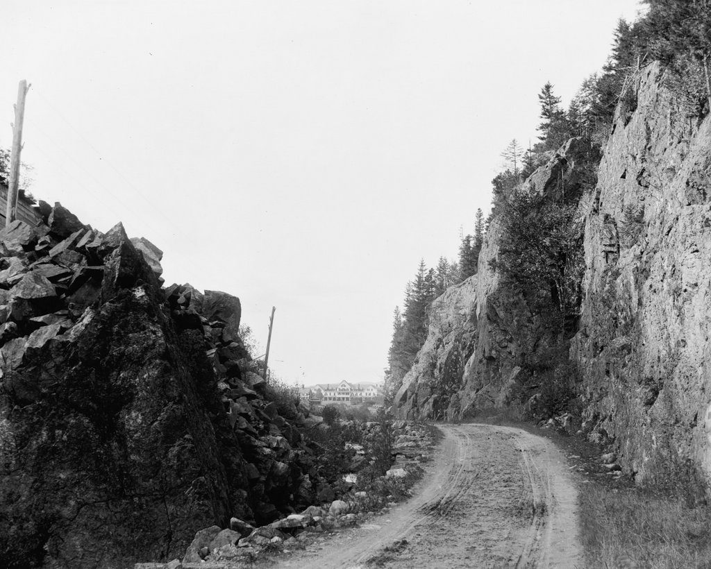
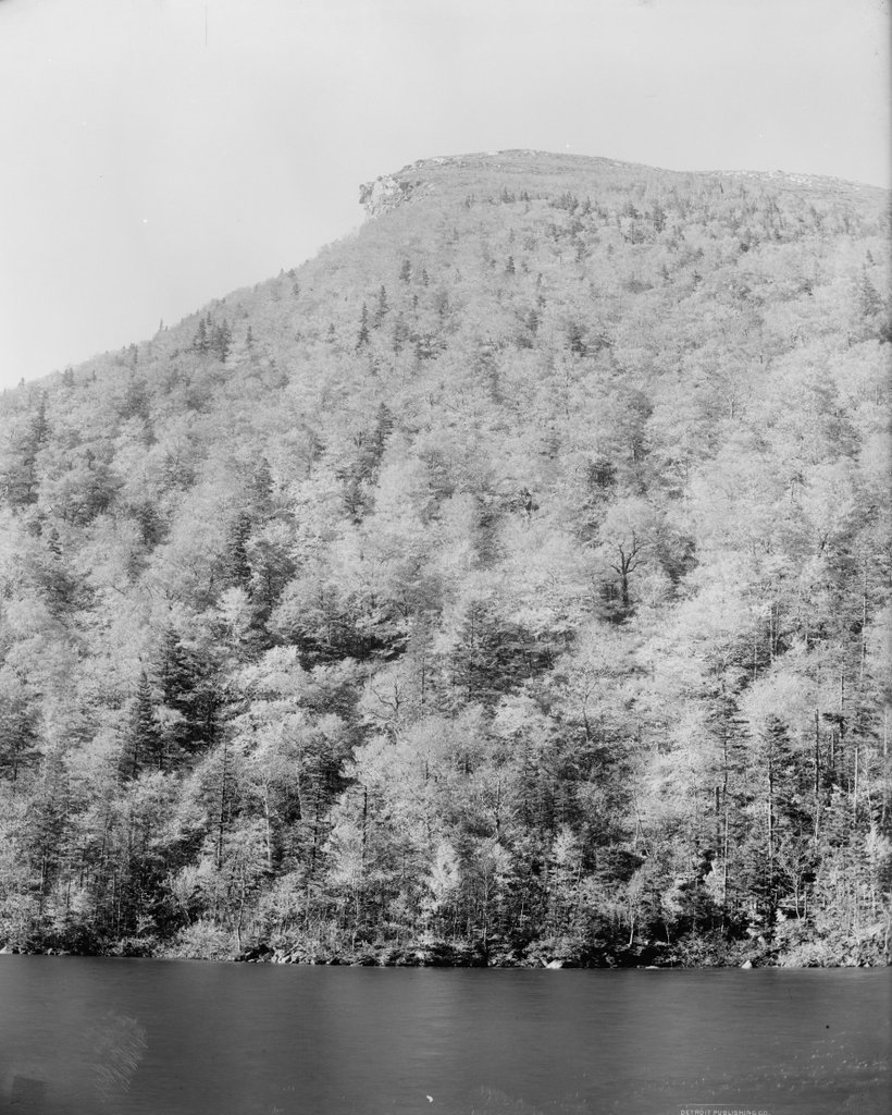
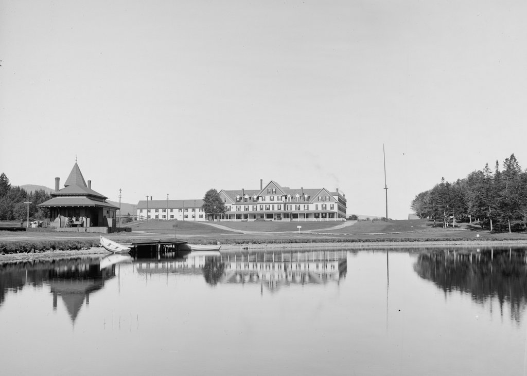
The Crawford House at Crawford Notch in the White Mountains of New Hampshire, seen from across Saco Lake, around 1891-1910. Image courtesy of the Library of Congress, Detroit Publishing Company Collection.
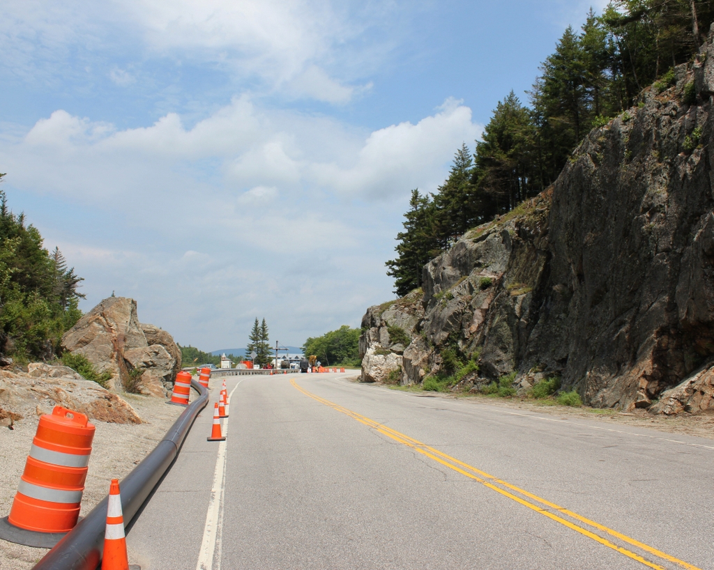
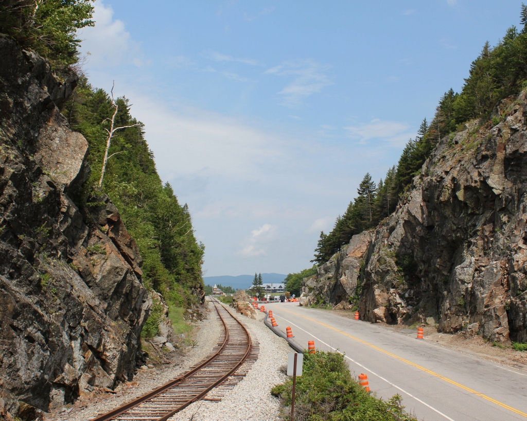
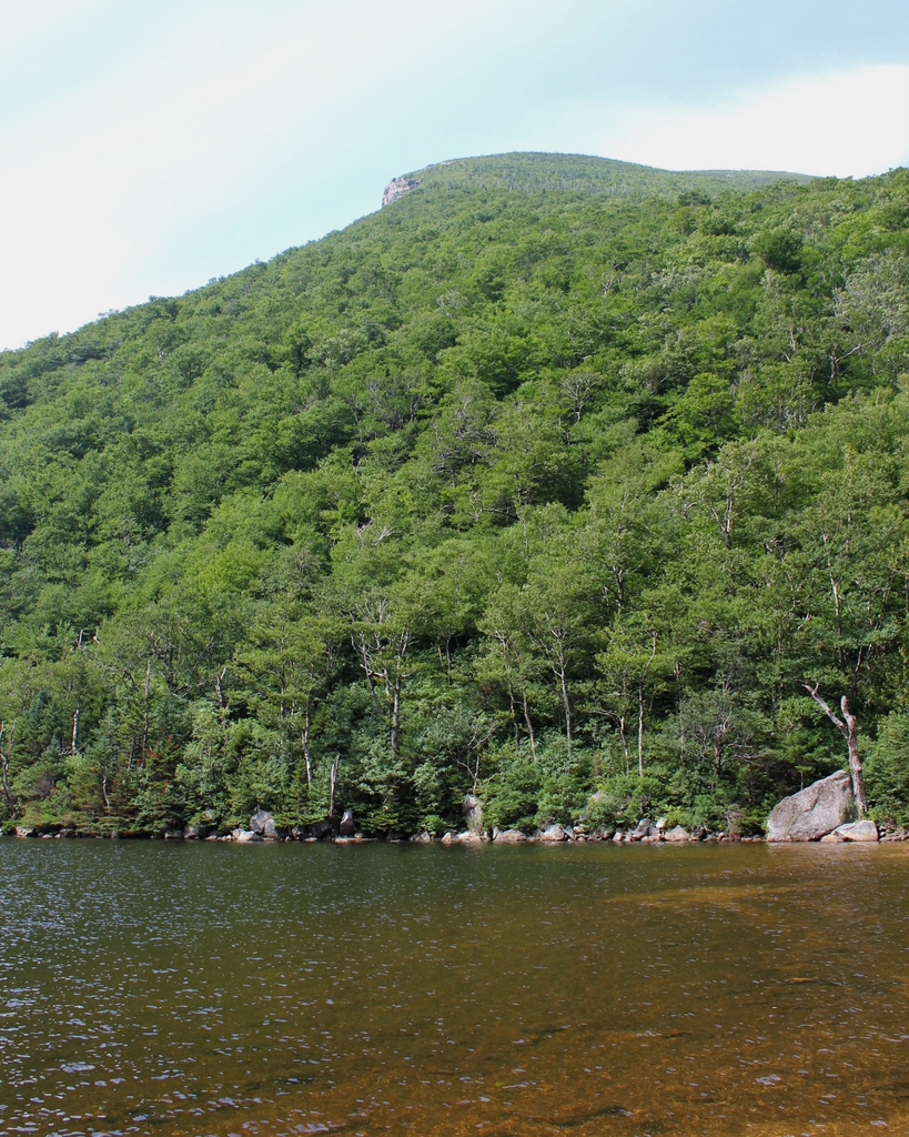
The scene in 2018:

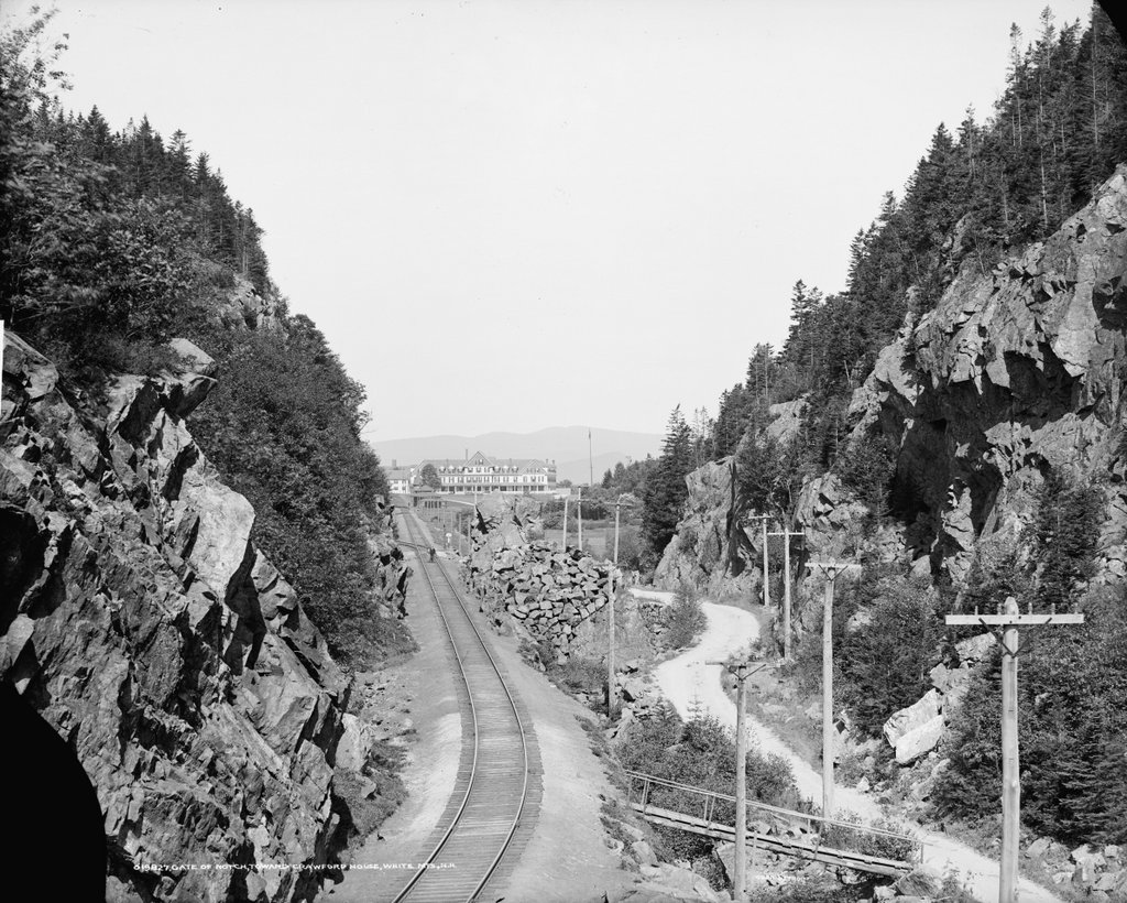
The first photo shows the Crawford House, one of the many large hotels that were built in the White Mountains during the second half of the 19th century. It stood just to the north of the gates of Crawford Notch, one of the most important mountain passes in the region. The location of the hotel was near the high point of the notch, at the divide that separates the watersheds of the Ammonoosuc and Saco Rivers. In the foreground of this scene is Saco Lake, which forms the headwaters of the Saco River. From here, the river flows southeast through Crawford Notch before emptying into the Atlantic Ocean just south of Portland, Maine. Less than a half mile to the north of here, on the other side of the hotel, is Ammonoosuc Lake, which ultimately drains into the Connecticut River and then to Long Island Sound.

This site was an ideal location for a hotel. At the time, this road was the only east-west route through the mountains, and this area to the north of Crawford Notch was relatively broad and flat, unlike the long, narrow valley to the south of here. The first hotel in this immediate vicinity was the Notch House, which was built in 1828 by Ethan Allen Crawford. He was the son of Abel Crawford, the first white settler to live near the notch, and his family operated several taverns in the area. Ethan’s brother Thomas became the manager here at the Notch House, and he ran it until 1852, two years before it was destroyed by a fire.

The Notch House was located near the spot where these two photos were taken, but around 1850 Thomas Crawford began construction of a new hotel nearby, on the site of the hotel in the first photo. However, he ran into financial problems before it was completed, and he had to sell the property in the early 1850s. The new owner finished the hotel, which became known as the Crawford House, but, like the Notch House, it fell victim to fire, burning on April 30, 1859.

Such fires were not uncommon in large resort hotels of this period, which were generally made almost entirely of wood and lacked effective fire suppression systems. Despite this setback, though, the hotel was quickly rebuilt. The work began on May 10, 1859 and it was completed in just two months, with the hotel holding a celebratory dinner here on July 13. This new Crawford House, which was still standing when the first photo was taken, was three stories high and originally measured about 200 feet in length, with two wings that extended back about the same distance. Overall, it was much larger than the old building on the site, and a July 1859 article in the Boston Evening Transcript declared it to be the largest hotel in the state.

Another New England newspaper, the Independent Democrat of Concord, New Hampshire, published a letter around the same time that the hotel opened. The letter described a journey through the White Mountains, and it paid particular attention to the new Crawford House. The writer commented on how quickly the hotel was built, and also provided a glowing description of its interior, writing:

It is not too much to say that the “New Crawford house” is an advance upon any other at the Mountains. Its dining hall is of magnificent proportions, measuring 85 feet by 40, and 14 feet high. The principal parlor is 60 feet by 40. The general reception room is large and airy; while the sleeping rooms, of which there are some 120, are large, high, and thoroughly ventilated, leaving nothing, in these respects, to be desired. Then, the whole house is to be furnished in the most elegant and substantial style, and the whole is to be lighted with gas.

Guests at the Crawford House could enjoy a variety of outdoor activities. There were short hikes to places such as Ripley Falls, Arethusa Falls, and the summit of nearby Mount Willard, and for the more ambitious there was the Crawford Path, which led 8.5 miles to the summit of Mount Washington. This trail, which began here at the Crawford House, was created by Abel and Ethan Crawford in 1819, and it was eventually incorporated into the Appalachian Trail, making it probably the oldest active hiking trail in the country today. Guests could hike these trails on their own, but the hotel also had ponies that they could ride, along with experienced guides to accompany them.

In 1870, the Crawford House was purchased by brothers Asa T. and Oscar F. Barron. At the time, they also operated the nearby Twin Mountain House and Fabyan House, and their hotel empire would subsequently include the Mount Pleasant House and the Summit House, which was located at the top of Mount Washington. Oscar died here at the Crawford House in 1879, and Asa died eight years later, but the Barron family would continue to run these hotels for many years.

For the first two decades of its existence, the Crawford House was not directly served by railroads, but in 1875 the Portland & Ogdensburg Railroad opened through Crawford Notch, making the hotel far more accessible to visitors. At the time, it was the only hotel in the vicinity of the notch, and it received a glowing review in the 1887 Chisholm’s White-Mountain Guide-Book, which included the following description:

[T]his is a good hotel of the first class, 1,900 feet above the sea, with broad and almost interminable piazzas, cool and airy halls, post-office, telegraph-office, livery-stable, bowling-alley, gaslights; environs which the landscape-gardener has justly approved; and a dining-room where even Epicurus or Uncle Sam Ward need not famish….

Near the front of the house is the pretty little Saco Lake, the cradle of the Saco River, and so far widened and deepened by art as to give a reason for being for the boats which float on its crystal tide. The rugged forest between the lake and the overhanging mountain has been combed and brushed and perfumed, and otherwise adorned for a summer pleasaunce, so that it has won the happily suggestive name of Idlewild.

In 1888, not long after this description was published, the rail line through the notch was acquired by the Maine Central Railroad. Three years later, the railroad built a new station here at the Crawford House, which is visible on the left side of this scene. It was built of wood, and it featured an ornate Queen Anne-style design, complete with a small tower on one corner of the building. Most hotel guests and other visitors to Crawford Notch would have arrived here by way of the station, and the building also served as the local freight house and post office.

By the time the first photo was taken at the turn of the 20th century, the Crawford House was owned by the firm of Barron, Merrill, & Barron. This partnership was comprised of Asa Barron’s sons, Oscar G. and William A. Barron, along with Cardenio H. Merrill, and the trio also ran the other Barron hotels here in the White Mountains. Merrill died a few years later in 1908 at the age of 68, and Oscar in 1913 at 62, but William continued to operate the hotel until 1947, when he retired and sold the property. He died in 1964 at the age of 96, only a week after the death of his son, William A. Barron Jr., who had served as a brigadier general in the Army during World War II and as chairman of the board of Gillette after the war.

The Crawford House outlasted most of the other 19th century grand hotels in the White Mountains, but it ultimately closed in 1975, nearly 120 years after the building was constructed. It was destroyed by a fire two years later, on November 20, 1977, and the property was subsequently acquired by the Appalachian Mountain Club, which constructed the Highland Center on the site. This building, which serves as a lodge and an educational center, stands in the center of the 2018 photo. Today, the only surviving building from the first photo is the railroad station on the left. It was added to the National Register of Historic Places in 1982, and it remains in use as a railroad station, serving as the northern terminus for most tourist excursion trains on the Conway Scenic Railroad.

Crawford Notch, Hart’s Location, New Hampshire (2)

The view looking north through Crawford Notch in the White Mountains of New Hampshire, around 1900. Image courtesy of the Library of Congress, Detroit Publishing Company Collection.

The scene in 2018:

As discussed in greater detail in the previous post, Crawford Notch is one of the major mountain passes through the White Mountains region. It was first discovered by European settlers in 1771, and a road was built through here a few years later. However, the notch was already known to Native Americans long before then, and they had a trail that passed through here.

Crawford Notch is several miles in length, consisting of a narrow valley through the mountains, but its narrowest point is here at the northern end of the valley, near the divide between the watersheds of the Ammonoosuc and Saco Rivers. This spot, with steep rock ledges on either side, became known as the gates of the notch, and it was originally just a little over 20 feet in width. Over the years, though, it has been steadily widened, as a result of improvements to the road and the construction of a railroad through here in 1875.

The first photo was taken around the turn of the 20th century, at the start of the automobile era, but the road through the notch still looked very primitive at the time. Despite its appearance, though, this road served as a vital corridor through the mountains. Prior to the construction of the Kancamagus Highway in the 1960s, it was the only east-west road in the White Mountains, linking northern Vermont with the coastal region of southern Maine.

In addition, Crawford Notch also provided tourists with access to the White Mountains region, and many began arriving here during the first half of the 19th century. In fact, the notch itself is named for the Crawford family, who ran several different hotels in the vicinity of Crawford Notch during this period. They also blazed a trail, later known as the Crawford Path, from the notch to the summit of Mount Washington, and provided guided tours for visitors. This trail is still in use today, as the oldest segment of the modern-day Appalachian Trail.

Probably the most famous hotel here at the notch was the Crawford House, which is visible in the distance of the first photo. This property had previously been owned by the Crawford family, and in 1850 Tom Crawford began construction on the hotel. However, he soon ran into financial problems, and he had to sell the unfinished hotel. It was subsequently completed by a different owner, although the building was destroyed by a fire only a few years later, in 1859. The Crawford House was rebuilt later in 1859, though, and this second hotel building was still standing when the first photo was taken.

Today, more than a century after the first photo, Crawford Notch remains an important route through the mountains, although this scene here at the gates of the notch has undergone some significant changes. The narrow road from the first photo, with its wagon tracks visible in the dirt, is now the much wider U.S. Route 302. Further in the distance, the Crawford House is gone. It stood here for many years, but the hotel ultimately closed in 1975 and the building burned two years later. The site of the hotel is now the Highland Center, a lodge and educational center that is run by the Appalachian Mountain Club. The only surviving building from the first photo is the railroad station, which is barely visible in front of the left side of the hotel. It was built in 1891, and today it is still in use, serving as the northern terminus for most trains on the Conway Scenic Railroad.

Crawford Notch, Hart’s Location, New Hampshire

The view looking northwest through Crawford Notch in the White Mountains of New Hampshire, around 1860-1875. Image courtesy of the New York Public Library.

The same view around 1907. Image courtesy of the Library of Congress, Detroit Publishing Company Collection.

The scene in 2018:

Crawford Notch is an important mountain pass within the White Mountains of New Hampshire. Until the completion of the Kancamagus Highway in the 1960s, it was the only east-west route through the mountain range, and over the years it has served as a major link between northern Vermont and the coastal region of southern Maine. The notch consists of a narrow valley that is several miles in length, but the actual mountain pass is here at the northern end of this valley, at a gap in the mountains that was originally barely 20 feet wide. This spot came to be known as the gate of the notch, because of the high rocks that stand on either side of the pass.

The highest point of Crawford Notch is just to the north beyond the gates, in the distance of this scene. At 1,900 feet in elevation, it forms the divide between the Ammonoosuc River, which flows west to the Connecticut River and then to Long Island Sound, and the Saco River, which flows east through Crawford Notch and then to Maine, where it empties into the Atlantic Ocean just south of Portland. To the northeast of here is the Presidential Range, which begins here at the Notch and reaches its highest point, Mount Washington, about 6.5 miles from here. In the opposite direction, to the southwest of the notch, is the Peimgewasset Wilderness, the largest wilderness area in the state.

The first recorded discovery of Crawford Notch occurred in 1771, when Timothy Nash and Benjamin Sawyer came across it while hunting. As the story goes, Nash had become lost while tracking a moose. He climbed a tree in order to get his bearings, and in the process he sighted the gates here at the northern end of the notch. The notch had long been known to Native Americans, but Nash and Sawyer were evidently the first Europeans to find it, and within a few years there was a rough road through here.

The notch was ultimately named in honor of the Crawford family, who became the first permanent settlers of the area. Around 1790, Abel Crawford built a house a little further to the north of here, where he remained for several years before selling it to his father-in-law, Eleazer Rosebrook. Crawford then moved to the southern end of the notch, around the site of the present-day town of Hart’s Location.

Both he and Rosebrook operated inns for travelers, and Crawford helped to pioneer tourism to the White Mountains region. After Rosebrook’s death in 1817, Abel’s son Ethan Allen Crawford inherited the property here at the notch. Two years later, the Crawfords constructed an 8.5-mile trail from the notch to the summit of Mount Washington, and provided guided trips for visitors. Now known as the Crawford Path, it is considered to be the oldest continuously-used hiking trail in the country, and it has been incorporated into the Appalachian Trail.

One early visitor to this region was Timothy Dwight IV, a prominent author and theologian who served as president of Yale from 1795 to 1817. He came to the Notch on at least two separate occasions, and provided a description of it in his book Travels in New England and New York. In this particular visit, he approached the notch from the north, facing the opposite direction of these photos, and he wrote:

The entrance of the chasm is formed by two rocks, standing perpendicularly at the distance of twenty-two feet from each other: one about twenty feet in height, the other about twelve. Half of the space is occupied by the brook, mentioned as the head stream of the Saco; the other half by the road. The stream is lost, and invisible, beneath a mass of fragments, partly blown out of the road, and partly thrown down by some great convulsion.

When we entered the Notch we were struck with the wild and solemn appearance of every thing before us. The scale, on which all objects in view were formed, was the scale of grandeur only. The rocks, rude and ragged in a manner rarely paralleled, were fashioned and piled on each other by a hand, operating only in the boldest and most irregular manner. As we advanced, these appearances increased rapidly. Huge masses of granite, of every abrupt form, and hoary with a moss which seemed a product of ages, recalling to the mind the “Saxum vetustum” of Virgil, speedily rose to a mountainous height. Before us, the view widened fast to the south-east. Behind us, it closed almost instantaneously; and presented nothing to the eye but an impassable barrier of mountains.

The first photo was taken more than a half century after Dwight wrote this account, but the notch still had much of the same rugged appearance that he would have seen. The road had been improved somewhat over the years, starting in 1806, when the Tenth New Hampshire Turnpike opened through the notch. By the late 1820s, the road was suitable for stagecoaches, but when the first photo was taken around the 1860s or 1870s, this section of the road still looked like a narrow dirt path through the wilderness.

Aside from the road, the only sign of civilization in the first photo is the Crawford House, which is barely visible in the distant center. The original Crawford House was built here in the early 1850s, but it burned in 1859. The hotel was quickly rebuilt on the same site, reopening later in 1859. This new building can be seen in both the first and second photos, and it stood here until it too was destroyed by a fire in 1977. The site of the hotel is now the Highland Center, a lodge and education center operated by the Appalachian Mountain Club.

Perhaps the most dramatic change in this scene occurred shortly after the first photo was taken, when a railroad was constructed through here. The first railroad across the continent had been completed in 1869, and by this point there was even a cog railway to the summit of nearby Mount Washington. However, it would take several more years for railroad engineers to conquer Crawford Notch. The project required several long trestles and deep rock cuts, along with the widening of the gap here at the gates of the notch. The grade of the railroad was also a challenge, with northbound trains having to ascend 1,623 feet in just 30 miles, but the Portland & Ogdensburg Railroad was ultimately completed through the notch in 1875.

In addition to improving transportation through northern New England, the railroad also provided passenger service to the heart of the White Mountains, making it easier for tourists to visit the region. Several of the grand hotels along the route even had their own stations, including the Crawford House, whose station is barely visible in the distance on the right side of the tracks in the second photo. This particular station building had been constructed in 1891, several years after the Maine Central Railroad acquired the Portland & Ogdensburg, and it is still standing today as the only surviving structure from the second photo.

In more than a century since the second photo was taken, the road through the notch has been widened and straightened. It has come a long way since the dirt path of the first photo, and it is now designated as U.S. Route 302, which runs from Portland, Maine to Montpelier, Vermont. Today, it remains as important a route through the White Mountains as it had been when the first road was constructed through here in the 18th century. In that sense, the road has actually outlived the railroad, which was abandoned by Maine Central’s successors, Guilford Transportation, in 1983. However, this section of railroad was ultimately acquired by the Conway Scenic Railroad, which operates excursion trains for tourists. The railroad also owns the station here in the distance, and it serves as the northern terminus for most of its trains.

Today, the White Mountains are still a popular tourist destination, and Crawford Notch is still a major focal point within the region. Most of the notch is within the town of Hart’s Location (population 41 as of 2010), but the northern border of the town is here at the gates of the notch, so the buildings in the distance are actually within the town of Carroll. The land on the Carroll side of the border is still privately owned, but the Hart’s Location side is part of the 5,775-acre Crawford Notch State Park. This park is, in turn, mostly surrounded by the much larger White Mountains National Forest, which covers more than 750,000 acres in New Hampshire and Maine.

Old Man of the Mountain, Franconia, New Hampshire

The Old Man of the Mountain, seen from Profile Lake at the base of Cannon Mountain, around 1890-1901. Image courtesy of the Library of Congress, Detroit Publishing Company Collection.

The scene in 2018:

The Old Man of the Mountain was previously featured on this blog many years ago, in a post that showed a closeup of the rock formation, before and after its collapse. Unlike that view, however, this scene here shows not just the rock formation, but also its surroundings, including the east side of Cannon Mountain and Profile Lake at its base. This is, more or less, the view that most visitors would see of the Old Man from the ground, without the aid of binoculars or telephoto lenses.

The iconic granite profile was formed at some point after the last ice age, as a result of erosion at the top of the cliff. It stood 1,200 feet above the surface of Profile Lake, and it was on the side of Cannon Mountain, which rises a total of 4,080 feet above sea level. Cannon Mountain forms the western side of Franconia Notch, an important mountain pass through the White Mountains, and by the early 19th century the Old Man of the Mountain had become a notable landmark for travelers passing through here.

The first recorded mention of the rock formation came in 1805, when a pair of surveyors observed it from near this location. As the story goes, they arrived here at dusk and camped along the shore of the lake. When they awoke in the morning, one of the surveyors looked up from the lake to discover the sun shining on the east-facing cliff, illuminating the stone profile.

Over the next few decades, the Old Man of the Mountain drew the attention of writers and other prominent people. New Hampshire native Daniel Webster famously declared, regarding the rock formation, that “God Almighty had hung a sign out to show that here He makes men.” Although originally from Massachusetts, poet John Greenleaf Whittier wrote extensively about the White Mountains, and he made reference to the Old Man of the Mountain in his 1850 poem, “The Hill-Top,” which includes the following lines:

Beyond them, like a sun-rimmed cloud,
     The great Notch mountains shone,
Watched over by the solemn-browed
     And awful face of stone!

Also in 1850, Nathaniel Hawthorne published a short story, “The Great Stone Face.” It was one of several stories that Hawthorne set in the White Mountains, and it included the following description of the formation:

The Great Stone Face, then, was a work of Nature in her mood of majestic playfulness, formed on the perpendicular side of a mountain by some immense rocks, which had been thrown together in such a position as, when viewed at a proper distance, precisely to resemble the features of the human countenance. It seemed as if an enormous giant, or a Titan, had sculptured his own likeness on the precipice. There was the broad arch of the forehead, a hundred feet in height; the nose, with its long bridge; and the vast lips, which, if they could have spoken, would have rolled their thunder accents from one end of the valley to the other.

In time, the Old Man of the Mountain became probably the most recognizable symbol of New Hampshire. Its rugged features paired well with the state’s “Live free or die” motto, and over the years it has appeared on everything from license plates to state highway signs to the 2000 New Hampshire state quarter. It has also appeared in countless paintings, postcards, photographs, and other illustrations over the years. The first photo was one of these, having been taken around the late 19th century by the Detroit Publishing Company, which produced postcards of landmarks across the country.

For more than a century after the first photo was taken, this scene remained essentially unchanged. However, as early as the 1870s, geologists has begun expressing concerns that the same forces of erosion that created the Old Man of the Mountain might soon destroy it. The many cycles of freezing and thawing had caused large cracks to form within the rocks, leading the state to secure it with chains in the 1920s. Then, in 1958, the formation was further reinforced with cement and steel rods. However, these measures ultimately proved to be only temporary solutions, because it finally collapsed on May 3, 2003, nearly 200 years after it was discovered here by the surveyors.

Today, with the exception of the loss of the rock formation, the rest of this scene still looks the same as it did when the first photo was taken. In fact, it is largely the same as it would have appeared in 1805, when the surveying team first spotted the Old Man of the Mountain from near this location. This area is now part of the Franconia Notch State Park, and it is surrounded by the much larger White Mountain National Forest, which preserves most of the land here in New England’s highest mountain range.

Calvin Coolidge House, Northampton, Mass

The house at 19-21 Massasoit Street in Northampton, around 1915-1920. Image courtesy of the Library of Congress, George Grantham Bain Collection.

The scene in 2018:

Throughout American history, there have been plenty of presidents who have come from humble beginnings, but few of them lived quite as modestly, both before and after their presidencies, as Calvin Coolidge. He was president throughout most of the Roaring Twenties, yet he had far more in common with his Puritan ancestors than with any characters in an F. Scott Fitzgerald novel. In many ways, he was the archetypal frugal Yankee, and one of the most visible examples of this was his choice of a residence here in Northampton. Rather than owning a home, he spent nearly 25 years renting the left side of this duplex, and it was here that he rose in the political ranks from a state legislator to president of the United States.

This two-family home was built around 1901, in a residential development about a mile to the northwest of downtown Northampton. Most of the other nearby houses were built around the same time, and they were generally single-family homes occupied by middle class residents. Calvin and Grace Coolidge moved in several years later, in August 1906, less than a year after they were married and only a few weeks before the birth of their first child, John. They occupied the left side of the house, at 21 Massasoit Street, for which they paid $27 per month for seven rooms and 2,100 square feet of living space.

Although he spent most of his life in Northampton, Calvin Coolidge was a native of Vermont, where he grew up in the family home in Plymouth. However, he came to Massachusetts for college, attending Amherst College and graduating in 1895. From there, he moved to nearby Northampton, the county seat, and began studying law as an apprentice in the firm of Hammond & Field. He was admitted to the bar in 1897, and soon began practicing law while also getting involved in local politics. He served on the city council, was subsequently appointed city solicitor, and then became Clerk of Courts of Hampshire County, where he worked in the old county courthouse.

Coolidge married his wife Grace in October 1905, when he was 33 and she was 26. Two months later, he suffered the only electoral defeat of his career, when he lost a race for school committee. However, the following year he was elected to the Massachusetts House of Representatives, only a few months after moving here to Massasoit Street. He was reelected to the legislature in 1907, but he declined to run for a third term in 1908. This was motivated in part by the birth of his second son, Calvin Coolidge, Jr., in April of that year. Returning to Northampton meant that he could devote his full attention to his law practice, in order to pay for the added expenses of a second child.

However, Coolidge did not stay out of politics for long. In the fall of 1909, he ran for mayor of Northampton, winning by a margin of just 107 votes. He went on to serve two one-year terms in city hall from 1910 to 1911, where he applied his own personal frugality to the city budget. He reduced the city’s debt while also lowering taxes, yet he also managed to increase teachers’ salaries, improve the roads, and make the police and fire departments more efficient. Coolidge’s cost-saving measures included blocking a proposed new city hall, which would have replaced the old building that had stood since 1850. As it turned out, this proved to be a sensible move, because the old building remains in use as city hall more than a century later.

In 1912, Coolidge returned to the State House, this time as a state senator. This began his meteoric rise in state politics, from mayor of a small city to governor of Massachusetts in just seven years. He served four years in the state senate, including the last two years as senate president, and in the fall of 1915 he became the Republican nominee for lieutenant governor. His running mate, Samuel W. McCall, had narrowly lost the gubernatorial race to David I. Walsh a year earlier, but McCall and Coolidge won in 1915. In an early sign of Coolidge’s popularity, he won the lieutenant governor’s race by over 52,000 votes, while McCall was elected governor by just 6,313 votes.

McCall and Coolidge were successfully reelected in 1916 and 1917. In 1918, McCall announced that he would not run for a fourth term, so Coolidge became the Republican nominee for governor. He defeated his Democratic challenger, businessman Richard H. Long, by over 17,000 votes, and he was inaugurated as governor on January 2, 1919. He would go on to win reelection in the fall of 1919, this time defeating Long by a commanding margin of 125,000 votes.

As was the case here in Northampton, Coolidge’s time as governor was marked by fiscal conservativism. The best example of this came in September 1919, when the Boston Police Department threatened to strike. At the time, the city’s police department was directly controlled by the governor, not the mayor, and Coolidge threatened to fire any striking officers. About three-quarters of the police force went on strike anyway, and Coolidge followed through with his threat, famously declaring, “There is no right to strike against the public safety by anyone, anywhere, any time.” The strike caused a temporary increase in crime and violence in Boston, but the National Guard soon restored order while the city hired and trained new officers.

The police strike earned Coolidge national attention. In the days before the strike, many feared that, if the Boston police offers were successful in their strike, it would inspire similar actions across the country, leading to local governments being essentially extorted by their own police. By taking a hard stance against the strikers, and by emphasizing the need for law and order, Coolidge became a hero to many, and he was seen as a rising star within the Republican Party. The strike also contributed to Coolidge’s overwhelming victory in the 1919 election, earning him more than 60% of the statewide vote.

As a result, Coolidge was viewed as a presidential contender in 1920. Warren Harding was ultimately chosen as the party’s nominee at the Republican National Convention in June, but Coolidge was selected as the vice presidential candidate. It was the first election after the passage of the 19th Amendment gave women the right to vote, and both Harding and Coolidge had been supporters of women’s suffrage. Women voted overwhelmingly for the Republican ticket, resulting in a landslide victory for Harding and Coolidge, who carried 37 states and won over 60% of the popular vote.

Upon becoming vice president, Coolidge and his family moved to Washington, where they lived at the Willard Hotel. However, they would maintain this house as their Northampton residence, throughout Coolidge’s time in Washington. His vice presidency was relatively uneventful for nearly two and a half years, but this all changed when Warren Harding died suddenly on August 2, 1923. Coolidge was visiting his father in Vermont at the time, and he was awakened early in the morning and informed that he had become president. The elder Coolidge, who was a justice of the peace, administered the oath of office to his son in the parlor of his house, and then Calvin Coolidge’s first act as president was to go back to bed.

Coolidge easily won reelection in 1924, winning 35 states and 382 electoral votes in a three-way race between Democrat John W. Davis and Progressive Robert M. La Follette. As was the case in Northampton and in Boston, Coolidge sought to cut taxes and lower spending while also reducing the national debt. He held a laissez-faire attitude toward the economy, and his presidency saw widespread growth and prosperity during what came to be known as the Roaring Twenties. However, his economic policies are sometimes criticized for the role that they may have played in the stock market crash of 1929, which occurred less than eight months after he left office.

Coolidge did not run for reelection in 1928, instead endorsing the candidacy of his commerce secretary, Herbert Hoover. He and Grace left the White House in March 1929, and they returned here to their home on Massasoit Street. The 1930 census listed Coolidge’s occupation simply as “retired,” and at the time they were paying $40 per month in rent, equivalent to about $620 today. They lived alone except for one servant, Alice Reckahn, who had been with the family since 1916 and had cared for the house while the Coolidges were in Washington.

It was certainly a modest home for an ex-president, but this did not seem to bother him. In his autobiography, published in 1929, Coolidge explained why he had lived here for so long, writing:

We liked the house where our children came to us and the neighbors who were so kind. When we could have had a more pretentious home we still clung to it. So long as I lived there, I could be independent and serve the public without ever thinking that I could not maintain my position if I lost my office. I always made my living practicing law up to the time I became Governor, without being dependent on any official salary. This left me free to make my own decisions in accordance with what I thought was the public good. We lived where we
did that I might better serve the people.

However, the location of the house proved to be a problem during Coolidge’s retirement. By this point, he was a prominent public figure, and his house offered little privacy from the many curious people who came down Massasoit Street to see the house. Author Claude M. Fuess, in his 1940 biography Calvin Coolidge, The Man From Vermont, provided the following description of the situation:

But Massasoit Street was sought by a continuous procession of sightseers; indeed Dr. Plummer [Frederic W. Plummer, principal of Northampton High School, who had lived in the unit on the right since about 1918], who still occupied the other side of the house, estimated that, in May, an automobile passed on the average every six seconds, and later in the summer the street was sometimes blocked with cars. The Coolidges did their best to lead a normal life. Mrs. Reckahn continued to act as housekeeper, and the flower garden was turned into a runway for the dogs brought from Washington. The ex-President tried to sit on the porch in the evening as he used to do. But whenever he appeared in public a crowd was sure to gather, and the unceasing demonstrations of popularity wore on his nerves. The house was altogether too near the street, and he soon found his conspicuous position highly distasteful.

As a result, in 1930 the Coolidges purchased a house at 16 Hampton Terrace, located just to the south of downtown Northampton. It was known as The Beeches, and it was situated on a large lot, at the end of a long driveway. From the street, the house was almost entirely hidden by trees, offering a much greater degree of privacy than they had been able to enjoy here on Massasoit Street. Calvin Coolidge lived there for the rest of his life, and he died there in 1933 at the age of 60. Grace remained at The Beeches for several more years, but by the late 1930s she had moved to a house at 11 Ward Avenue, which stands less than a half mile away from their former home here on Massasoit Street.

The first photo shows the Massasoit Street house at some point during the late 1910s, probably when Coolidge was either lieutenant governor or governor. A century later, there have been a few changes, including the removal of the shutters and the balustrade over the porch on the right side, and the addition of a downspout on the front of the house. Overall, though, the exterior remains essentially the same as it did when Calvin Coolidge moved in here as a small-town attorney in 1906, and today it remains in use as a private residence. In 1976, the house was added to the National Register of Historic Places, but the only visible sign of its historical significance is a small plaque on the front porch, which identifies it as having been the home of Calvin Coolidge.

The Elms, Newport, Rhode Island (2)

The garden on the south side of The Elms in Newport, in 1914. Image taken by Frances Benjamin Johnston, courtesy of the Library of Congress, Johnston Collection.

The scene in 2018:

As in the previous post, the first photo here was taken by noted photographer Frances Benjamin Johnston. Her specialties included photographs of gardens, and many of these – including this photo – were hand colored on lantern slides, for Johnston to use in her various lectures. This photo is one of several that she took here at The Elms in Newport, and is shows the meticulously-landscaped garden on the south side of the house. At the time, Newport was still one of the most desirable summer resorts in the country, and The Elms had been built 13 years earlier by coal tycoon Edward Julius Berwind.

The family spent many summers here, and after Edward’s wife Sarah died in 1922, he continued to visit here, accompanied by his sister Julia. She inherited the property after his death in 1936, and it remained her summer home for the rest of her life, until her death in 1961 at the age of 96. Up until this  point, the house was still staffed by an army of 40 servants, long after most of the other massive Gilded Age mansions in Newport had been either demolished, converted to other uses, or preserved as museums. By the early 1960s, such homes had long since fallen out of fashion, and no other members of the Berwind family were interested in taking on the expense of maintaining a 48-room, 60,000-square-foot summer house.

As a result, the house was nearly demolished in 1962 in order to construct a shopping center here on the site. However, several weeks before it was to be demolished, The Elms was instead purchased by the Preservation Society of Newport County and opened as a museum. Both the house and the grounds have been preserved, and it is now one of many historic Newport properties maintained by the Preservation Society. This particular garden scene is not completely identical to its early 20th century appearance, particularly with the lack of hedges in the foreground, but the statue in the distance is still there, as are the ones on the patio to the left. Overall, the scene is still easily recognizable from the first photo, despite more than a century since Johnston captured this view in the first photo.