Mount Washington Hotel, Carroll, New Hampshire

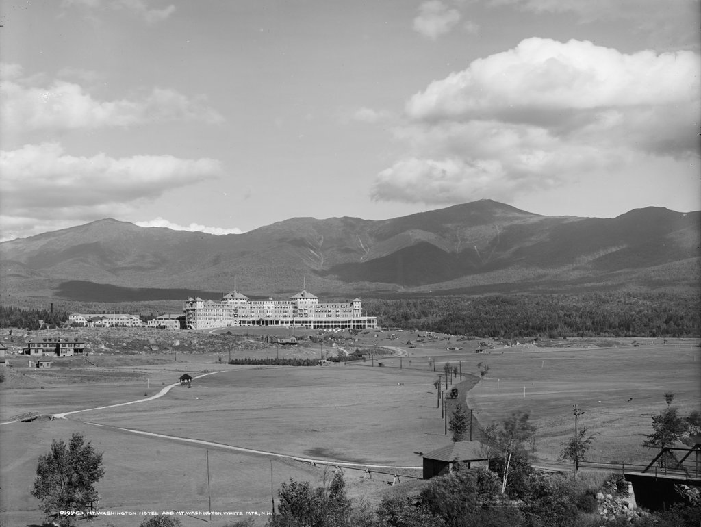
The Mount Washington Hotel, with its namesake mountain behind it in the distance, around 1906. Image courtesy of the Library of Congress, Detroit Publishing Company Collection.

The scene in 2020:

The White Mountains became a popular tourist destination during the second half of the 19th century, and the region featured a number of grand hotels. However, few could match the Mount Washington Hotel, which was built here in the Bretton Woods area of Carroll, New Hampshire between 1900 and 1902. It was owned by Joseph Stickney, a coal tycoon who had been involved in White Mountain hotels since 1881, when he purchased the Mount Pleasant House. Located approximately where these two photos were taken, the Mount Pleasant House started small, but it was subsequently expanded under Stickney’s ownership and became a prosperous hotel.

Around the turn of the century, Stickney decided to build an even larger hotel across the street from the Mount Pleasant House. He hired noted New York architect Charles Alling Gifford, who designed this Spanish Renaissance-style building, as shown in these two photos. It has a Y-shaped footprint, and its most distinctive exterior features are the two large octagonal towers. The hotel was completed in 1902 at a cost of about $2 million, and it formally opened on July 31, with a ball that was attended by dignitaries such as Chester B. Jordan, the governor of New Hampshire.

Upon completion, the hotel had 352 rooms and could accommodate around 600 guests. A night’s stay cost $20, which was a substantial amount of money at the time, and it included the room and three meals. Writing about a month before it opened, the Boston Herald declared it to be “one of the largest and most perfectly appointed resort hotels not only in New England, but in the summer resort world.” The article continued with the following description of the hotel:

It will contain, besides the ordinary accommodations for the comfort of guests, many novel and attractive features. The music room is 115 by 73 feet in size, with a spacious stage at one end to be used for amateur theatricals, and the rotunda, which is 135 by 103 feet, is the largest in any hotel in New England. The octagonal dining room in the northwest wing is 84 by 84 feet, and will seat 500 people. On two sides are spacious galleries, which can be utilized for the orchestra. Every suite has a private bath, and the chambers are all very large.

On the ground floor are the indoor amusements, including billiard rooms, ping-pong tables, golf club quarters, gun room, clubroom, bicycle room, shuffle boards, a large play room for children, and a mammoth swimming pool filled with water from the Ammonoosuc River, and tempered by steam jets to the right warmth. The floor of the pool is tiled, and adjoining are dressing and toilet rooms, with facilities for Turkish baths.

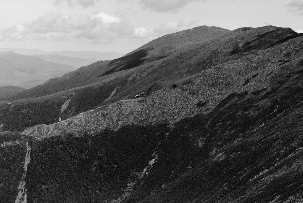
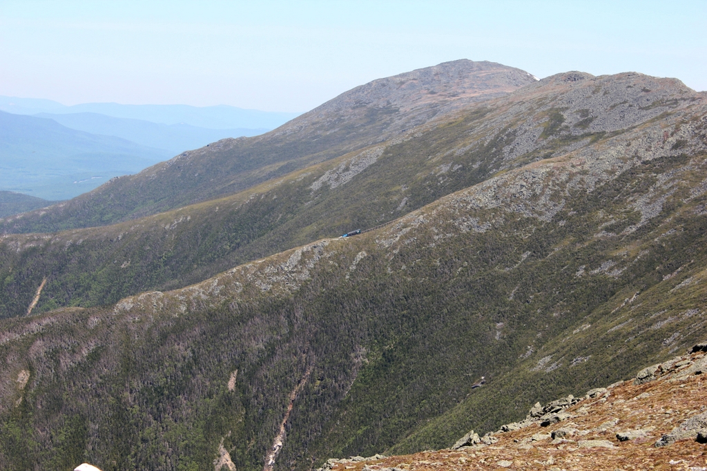
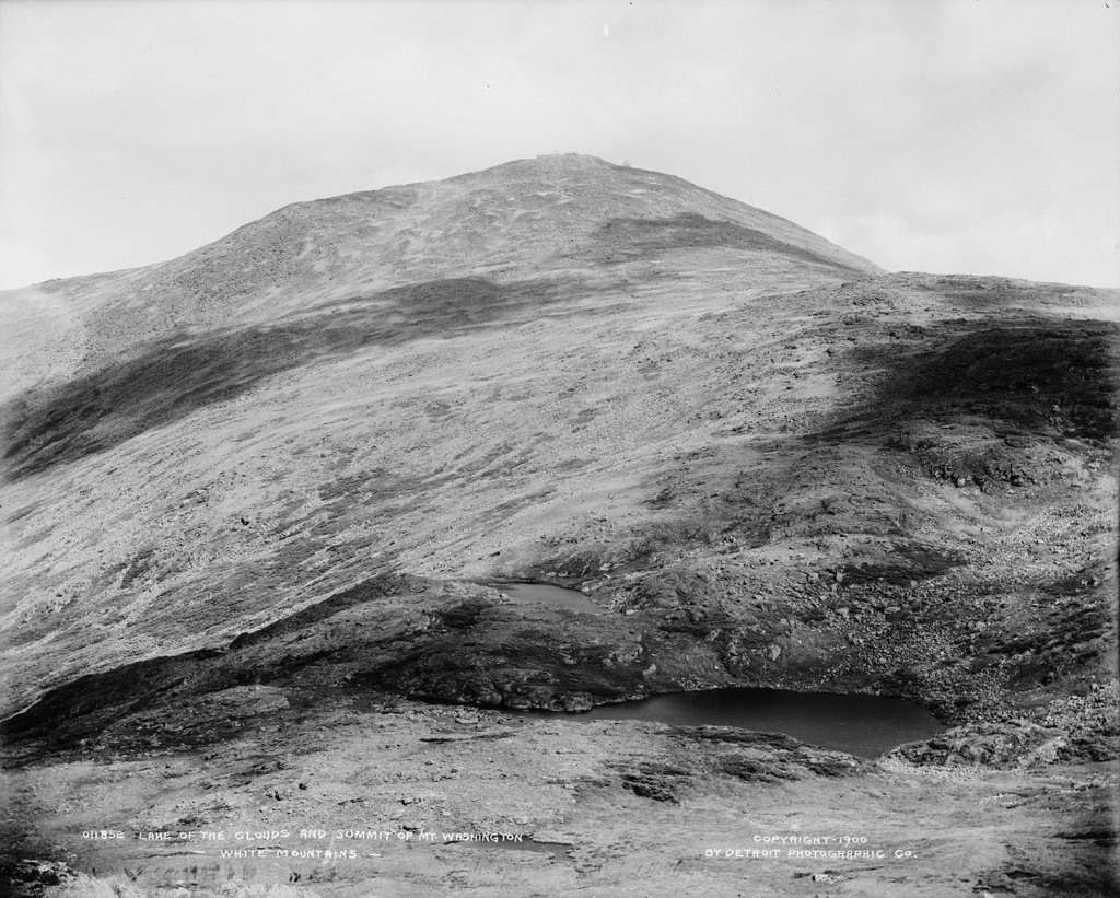
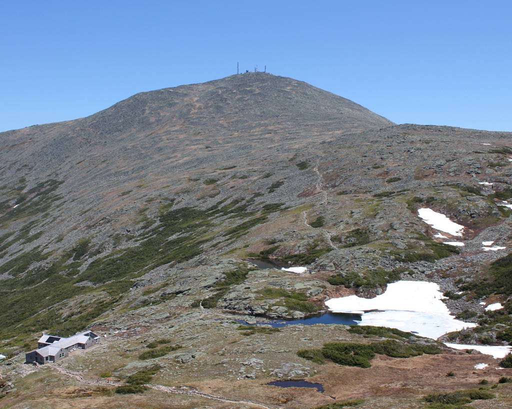
The first photo was taken only a few years after the Mount Washington Hotel opened. It shows the building and grounds from the main road, about a half mile away. In the foreground is the bridge over the Ammonoosuc River and the long driveway to the hotel. In the distance is the hotel’s namesake mountain, Mount Washington, which stands beyond and to the right of the hotel. The summit is about seven miles east of the hotel, and about 4,600 feet higher in elevation. Rising 6,288 feet above sea level, it is the highest mountain in the northeastern United States, and it is flanked by other peaks in the Presidential Range, including Mount Jefferson on the far left and Mount Monroe on the far right.

The Mount Washington Hotel was a popular resort destination throughout the early 20th century, drawing prominent guests such as Woodrow Wilson, Warren Harding, Winston Churchill, Thomas Edison, Mary Pickford, and Babe Ruth. However, the most famous gathering here occurred in July 1944, in the midst of World War II, when 730 delegates from 44 Allied nations met at the Mount Washington Hotel. Known as the Bretton Woods Conference, this meeting was held in anticipation of the end of the war, in order to establish international monetary policies for the postwar world.

The Bretton Woods Conference delegates included many of the world’s leading economists, including Harry Dexter White, John Maynard Keynes, and U.S. Secretary of the Treasury Henry Morgenthau Jr., who presided over the conference. Among the agreements reached here were the establishment of the International Monetary Fund and the World Bank, along with policies for currency exchange rates. The conference led to what became known as the Bretton Woods system, which remained the predominant international economic system until the early 1970s.

In the meantime, the mid-20th century was a difficult time for the grand 19th century hotels in the White Mountains. Many succumbed to fire, while others faced a slow, steady decline as the buildings aged and tourist preferences shifted. However, the Mount Washington Hotel managed to avoid the fate of nearly all its contemporaries, and it still stands here nearly 120 years after it opened.

Today, there have been few significant exterior changes to the hotel, and the scene still looks much the same as it did at the turn of the 20th century, although the trees are now much taller and partially hide the building from this spot. Now known as the Omni Mount Washington Resort, it remains one of the premier hotels in the region, and it stands as a rare surviving Gilded Age resort hotel here in New England. Because of its historic significance, particularly with regards to the Bretton Woods Convention, the hotel was added to the National Register of Historic Places in 1978, and it was designated as a National Historic Landmark in 1986.

Crawford Notch, Carroll, New Hampshire (2)

The view looking south toward Crawford Notch in New Hampshire, as painted by Thomas Cole in 1839. Image courtesy of the National Gallery of Art.

The scene in 1841, photographed by Dr. Samuel A. Bemis. Image courtesy of the Art Institute of Chicago.

The scene around 1890-1901. Image courtesy of the Library of Congress, Detroit Publishing Company Collection.

The scene in 2020:

This view is similar to the one in the previous post, although this one is a little further to the south, showing a closer view of the dramatic gap in the mountains at Crawford Notch. It is a view that has long captivated artists and photographers, as shown by the many different images here. This particular angle looks south through what are known as the gates of Crawford Notch, the narrowest point in the mountain pass. Barely 20 feet wide when discovered by European colonists in 1771, it has subsequently been widened to accommodate road and rail traffic, but it still retains much of the same appearance, with the steep cliffs on either side and the slopes of Mount Webster looming in the background. On the left side of the notch is an exposed rock formation known as Elephant Head, due to its somewhat vague resemblance to the head and upper trunk of an elephant.

The first image here is a painting of Crawford Notch by prominent landscape artist Thomas Cole. He is generally regarded as the founder of the Hudson River School, an artistic movement that emphasized the natural beauty of the American landscape. Cole typically used his artwork to convey the power of nature, and this painting features several of his common motifs, including gnarled trees, ominous storm clouds, and a small human figure that is barely noticeable amid the surrounding landscape. Perhaps the most foreboding element is the dense fog in the valley beyond the notch, giving a sense that the notch is a sort of passage to another world.

Thomas Cole made several visits to the White Mountains, including one in the summer of 1839, accompanied by fellow artist Asher Durand. While here, he sketched this view of Crawford Notch, and he painted this painting after returning to his home in Catskill, New York. Titled A View of the Mountain Pass Called the Notch of the White Mountains (Crawford Notch), it was commissioned by Rufus L. Lord, who paid Cole $500 for the finished work. It is now regarded as one of Cole’s finest American landscapes, and it is currently on display at the National Gallery of Art in Washington, D.C.

The second image here is a daguerreotype taken in 1841, just two years after Cole’s visit. It is the oldest photograph that I have featured on this blog, and among the earliest photographs to be taken in the United States, just a few years after Louis Daguerre invented the daguerreotype process. The photographer was Dr. Samuel A. Bemis, a Boston dentist who became one of the first photographer in the country. He began taking photographs in 1840, but evidently abandoned the hobby around 1843, leaving behind a relatively small number of photographs, most of which are poorly exposed. However, his works include the earliest photographic images of the White Mountains, many of which were taken in and around Crawford Notch.

This particular photograph shows nearly the same scene that Thomas Cole had painted two years earlier, although Bemis was a little closer to the notch than Cole was when he sketched the view. On the left side is the Notch House, which appears to be the same building shown in the distance on the left side of the painting. This inn was built in 1828 by Ethan Allen Crawford, and it was operated by his brother Thomas. From here, visitors could ascend to the summit of Mount Washington by way of the 8.5-mile Crawford Path, which Ethan Allen Crawford and his father Abel had cut in 1819.

In 1845, a few years after the photo was taken, the Notch House was expanded with a new addition. The attic was also converted into rooms, giving the inn a capacity of 75 guests. Then, around 1850 Thomas Crawford decided to build a new hotel nearby, just a little to the north of here. However, he ran into financial trouble and ended up having to sell the partially-completed hotel in December 1850. The hotel was finished under the new ownership, and it was named the Crawford House, with Joseph L. Gibbs as its manager. With this new, modern hotel nearby, the old Notch House quickly faded into obscurity. It was used occasionally for overflow accommodations, but it was ultimately destroyed by a fire in June 1854.

The Crawford House ultimately suffered a similar fate when it burned in 1859, but it was quickly rebuilt on the same site and stood there for well over a century, until it too was destroyed by fire in 1977. By the time the third image was taken of Crawford Notch in the 1890s, it was a popular resort destination. The hotel was located about a quarter mile behind where this photo was taken, so it is not visible in this scene, but there are other signs of changes here in the 1890s photo, particularly the railroad. In the 1841 image, the Notch House would have been accessible only by stagecoach, but in 1875 the Portland & Ogdensburg Railroad opened through the notch, making it much easier for tourists to visit the area.

Today, nearly two centuries after Thomas Cole painted Crawford Notch, the foreground of this scene has undergone substantial changes. Cole himself hinted at some of these impending changes with the cleared ground and tree stumps, but he probably did not anticipate that a railroad would one day be built through here, or that the rough stagecoach road would eventually become the modern US Route 302. However, despite these changes, the surrounding landscape has remained nearly unchanged. Cole did embellish parts of the scene, including the prominence of Mount Webster and the narrowness of the notch, but overall the landscape is still instantly recognizable from the painting, and Crawford Notch remains one of the most impressive natural features in the White Mountains.

Crawford Notch, Carroll, New Hampshire

The view looking south toward Crawford Notch from the Crawford House in Carroll, New Hampshire, around 1900. Image courtesy of the Library of Congress, Detroit Publishing Company Collection.

The scene in 2020:

As explained in an earlier post that shows the view from the opposite direction, Crawford Notch is an important mountain pass that, for many years, was the only east-west route through the White Mountains. The notch, which was originally barely 20 feet wide, was unknown to European colonists until 1771, when two settlers discovered it while hunting. It soon became a major transportation corridor, beginning with a rough road that was later upgraded for stagecoach travel. By the late 19th century, a railroad also ran through the notch, as shown by the tracks and station building in both photos.

Like most mountain passes, Crawford Notch forms the divide between two major rivers. In the foreground of this scene is Saco Lake, the headwaters of the Saco River. From here, the river runs through the gap in the mountains, which is known as the “gates” of Crawford Notch. The river then flows through a narrow, steep-sided gorge for several miles, and it ultimately flows through Maine and into the Atlantic Ocean a little south of Portland. On the other side of the divide is the Crawford Brook, which rises just behind where these photos were taken and flows into the Ammonoosuc River. The Ammonoosuc River then flows into the Connecticut River, which eventually reaches the ocean in Long Island Sound.

These two photos show perhaps the most dramatic view of Crawford Notch, looking south from right about the point where the two watersheds divide. From here, the relatively broad, flat valley on the north side of the notch narrows to a small opening that is flanked by steep cliffs on either side. Just to the left of the notch is a rock formation known as Elephant Head, and on the right is the eastern slope of Mount Willard. However, the most prominent landscape feature here is Mount Webster, which forms an impressive backdrop to the scene. At 3,911 feet in elevation, its summit rises two thousand feet above the floor of Crawford Notch, and it forms the southern end of the Presidential Range.

Given the amount of traffic that was funneled through Crawford Notch, the area was the site of several hotels and inns in the early 19th century. Perhaps the most famous of these was the Willey House, located about three miles south of here. In 1826, the occupants of the inn were killed in a landslide, after they fled the house in the middle of the night in an effort to escape the falling rocks and mud. Ironically, the building itself was unharmed by the landslide, and the tragic event was subsequently immortalized in paintings and literary works.

Many accounts of the tragedy made it a moral lesson about the untamed power of nature, yet it did little to dissuade visitors to Crawford Notch. If anything, it seemed to have the opposite effect, and by the mid-19th century the area was no longer simply a convenient transportation corridor; it had become a destination in its own right. Among those who benefitted from this was the Crawford family, for whom the notch is named. In 1828, just two years after the landslide, Ethan Allen Crawford built the Notch House here at the gates of Crawford Notch, and his brother Thomas subsequently ran it for many years. From here, the Crawfords offered guided tours to the summit of Mount Washington via the 8.5-mile Crawford Path, which Ethan Allen Crawford and his father Abel had cut in 1819.

The original Notch House was located in the distance of this scene, close to the actual notch. However, in the early 1850s Thomas Crawford began construction on a new hotel just to the north, located where these two photos were taken. He ran into financial difficulties and had to sell the half-finished hotel, but it was completed under new ownership. However, the building was destroyed by a fire in 1859, and was subsequently rebuilt and reopened later in the year. Known as the Crawford House, it became a popular tourist destination throughout much of the 19th and 20th centuries. It ultimately closed in 1975, and burned two years later.

When the Crawford House opened, there was no rail service through Crawford Notch. However, this changed in 1875, when the Portland & Ogdensburg Railroad opened here. This railroad was subsequently acquired by the Maine Central Railroad in 1888, and in 1891 the new owners built a Queen Anne-style station here at the Crawford House, which is visible in the foreground of both photos. The first photo shows a locomotive at the station, Maine Central No. 101, a 4-4-0 steam locomotive that was built in 1889 and scrapped in 1916.

Today, around 120 years after the first photo was taken, relatively little has changed in this scene. Right behind where the photos were taken, the Crawford House is long gone, and it is now the site of the Appalachian Mountain Club’s Highland Center. However, the view south toward the notch looks much the same as it did in 1900, including the historic railroad station, Saco Lake, and the surrounding landscape. Most of the land within Crawford Notch is now part of the Crawford Notch State Park, which was established in 1913, and the surrounding land on the mountains is part of the White Mountain National Forest, which was established in 1918.

Mount Jefferson from Mount Monroe, New Hampshire

Mount Jefferson and the northern Presidential Range from near the summit of Mount Monroe, around 1900. Image courtesy of the Library of Congress, Detroit Publishing Company Collection.

The scene in 2020:

The first photo here was taken from the same spot, and perhaps even on the same day, as the one in the previous post. However, while that photo shows the summit of Mount Washington from Mount Monroe, this view looks a little further to the west, showing the western side of Mount Washington with Mount Jefferson further in the distance. As was the case with the previous post, I took the 2020 photo without having first seen the 1900 one. I took the photos during a hike along the southern Presidential Range from Crawford Notch to Mount Monroe, and later discovered that several of the photos lined up perfectly with ones that were taken around 1900 by the Detroit Publishing Company. In this particular view, perhaps the most remarkable similarity is that both photos show a Mount Washington Cog Railway train in the exact same location, right in the center of the photo.

The highest mountain visible in this scene is Mount Jefferson, which is a little over three miles away from here. At 5,712 feet, it is the third-highest peak in the northeastern United States, after the nearby Mount Washington and Mount Adams. Along with Mount Madison and Mount Monroe, these comprise the five highest peaks in the region, and they are named in honor of the first five presidents, with the elevation rank corresponding to the order in which they served as president. However, Madison and Monroe are very close in elevation, and subsequent surveys discovered that Monroe is actually slightly higher, despite being named for the fifth president.

Aside from Mount Jefferson, the most visible landscape feature here is Ammonoosuc Ravine, a large glacial cirque in the foreground that forms the western slope of Mount Washington. Further in the distance is Burt Ravine, a somewhat smaller cirque to the northwest of Mount Washington. In between these two ravines is a ridgeline that runs diagonally across this scene. The steep slopes of this ridge, combined with the heavy precipitation here, makes it prone to landslides, and both photos show the scars of large slides here on the southern side of the ridge.

Both photos also show the Mount Washington Cog Railway, which runs along this ridge between Ammonoosuc and Burt Ravines. Completed in 1869, this three-mile railroad was a major engineering feat, with trains rising about 3,500 feet in elevation from the base station to the summit. This was far too steep for conventional trains, so the railway’s founder, Sylvester Marsh, developed a rack-and-pinion system with a gear on the locomotive that engaged a rack in the center of the track. This allowed the gear to pull the train up the mountain, and then safely lower it in a controlled descent on the return trip.

The Mount Washington Cog Railway was the first of its kind in the world, and it today it is the world’s second-steepest railroad. The single steepest part of the route is a trestle known as Jacob’s ladder, with a maximum grade of more than 37%. This trestle is visible in the center of both photos, and coincidentally both photos show a train at the same spot at the base of the trestle. As was the case more than a century ago, the trains still climb and descend with the locomotive always on the downhill side of the train and a single passenger coach facing uphill. The only difference is the type of locomotive; for most of the railroad’s history it operated steam locomotives, but it now primarily uses biodiesel locomotives, which are more environmentally friendly and less expensive to run.

Overall, the type of locomotive on the trestle is essentially the only difference between these two photos. Although the summit of Mount Washington has been heavily developed with over the years with many buildings and other structures, the rest of the Presidential Range has remained largely unchanged, with few signs of human activity aside from hiking trails. Most of the range, along with much of the surrounding land, is now protected as part of the White Mountain National Forest, which was established in 1918 and has grown to over 750,000 acres of land in New Hampshire and Maine.

Mount Washington from Mount Monroe, New Hampshire

The summit of Mount Washington, seen looking north from Mount Monroe in the Presidential Range of the White Mountains, around 1900. Image courtesy of the Library of Congress, Detroit Publishing Company Collection.

The view in 2020:

Rising 6,288 feet above sea level, Mount Washington is the highest peak in the northeastern United States. It stands at the center of the Presidential Range, a north-south oriented mountain range that forms a massive ridgeline of bare rocks and alpine vegetation. The range is infamous for its harsh and unpredictable weather, particularly at the summit of Mount Washington, which for many years held the world record for fastest surface wind speed ever recorded, at 231 miles per hour. Hypothermia is a year-round threat to hikers, and although there is no permanent ice cap, pockets of snow can linger well into the summer, as shown in the 2020 photo, which was taken on June 18.

Aside from Mount Washington, most of the other peaks in the range are also named for presidents. The five highest peaks are named after the first five presidents, in order of elevation, so that Mount Adams is the second-highest and Jefferson the third-highest. However, Mount Monroe, where these photos were taken from, is actually the fourth-highest, but it was named for the fifth president because of a surveying error. Monroe is the southernmost of these five major peaks; to the south are several lower peaks in the Presidential Range, including Mount Eisenhower and Mount Pierce.

Mount Washington’s high elevation and inhospitable climate have long attracted visitors to the summit. The first recorded ascent occurred in 1642, when Darby Field climbed the mountain accompanied by two Native American guides. Governor John Winthrop recorded the event in his diary, referring to the mountain as “the white hill,” since the mountain’s eventual namesake would not be born for another 90 years. Field’s exact route is uncertain, but he evidently approached it from the south, as Winthrop mentions two ponds along the way, which were likely the Lakes of the Clouds shown here in this scene. Aside from helping determine Field’s route, the mention of the lakes also helps to verify his ascent, since he would not have known about them unless he actually climbed at least this far.

The mountain was only occasionally climbed during the rest of the 17th and 18th centuries, but this began to change in the early 19th century. In 1819, local residents Abel and Ethan Allen Crawford cut an 8.5-mile path from Crawford Notch to the summit of Mount Washington, following the ridgeline of the southern Presidential Range. The trail passed through this scene just to the East of the summit of Mount Monroe, and most of it is still in use today as part of the Appalachian Trail, making it the oldest continuously-maintained hiking trail in the country. Ethan Allen Crawford built a cabin, and later a hotel, at the base of the trail, and he also acted as a guide for hiking groups setting out from Crawford Notch. The Crawford family later improved the trail for use as a bridle path, and by the 1840s visitors could ride to the top of the mountain on horseback.

The first building at the summit was a small hotel that opened in 1852. It was joined a year later by the rival Tip Top House, which still stands atop the mountain today. At the time, the only ways to get to the top were by foot or by horseback, but this would soon change. The Mount Washington Carriage Road opened in 1861, bringing visitors up the east side of the mountain, and the Mount Washington Cog Railway followed eight years later on the western slopes of the mountain. These two routes helped to spur more development, and by the time the first photo was taken around 1900 the summit was crowded with buildings, including the Tip Top House, a weather observatory, and the massive Summit House hotel, which could accommodate 150 guests. The summit even had its own daily newspaper, Among the Clouds, which was published during the summer months from 1877 to 1917.

By the late 19th century it was easier than ever to reach the summit, but many visitors chose to test their abilities by hiking up the mountain. However, because of the mountain’s notorious and often unpredictable weather, this sometimes led to tragic consequences for unprepared or unlucky hikers. The first known fatality in the Presidential Range was Frederick Strickland, who began his hike on October 19, 1849, when the mountain was already covered in deep snow. He climbed via the Crawford Notch, and he would have passed through this scene on his way up the mountain. Strickland made it to the top, becoming the first known hiker to do so in winter conditions, but he ultimately succumbed to hypothermia while descending the western side of the mountain. His body was discovered well below the tree line, near where the present-day Jewell Trail crosses Clay Brook.

One of the most famous tragedies on the mountain occurred on June 30, 1900, when William Buckingham Curtis and Alan Ormsbee both died of hypothermia while ascending the mountain. Both men were experienced outdoorsmen, and Curtis was renowned as an athlete and promoter of amateur athletics. As with Frederick Strickland a half century earlier, they hiked up the Crawford Path from Crawford Notch. Their goal was to attend the Appalachian Mountain Club meeting at the summit, but they faced harsh conditions along the way, including dense fog, sleet, and high winds. They climbed to the summit of Pleasant Dome (now Mount Eisenhower), and they were last seen alive soon after by a descending group that warned them of the deteriorating conditions ahead.

The first photo was probably taken within a year or two of Curtis’s and Ormsbee’s deaths, and it shows the section of the mountain where their journey came to an end. It is unclear as to whether they took the Crawford Path to the east of Mount Monroe, or if they took  the loop trail over the summit, but just to the north of Monroe they took shelter in a dense stand of stunted spruce trees. For unknown reasons, they subsequently left this shelter, and Curtis’s body was discovered a short distance beyond the trees, somewhere near the foreground on the far right side of these two photos. Ormsbee managed to continue up the mountain, but he ultimately died just a few hundred feet short of the summit.

In the aftermath of this tragedy, the Appalachian Mountain Club built a small shelter here in the area between Mount Monroe and Mount Washington, near the spot where Curtis died. It was completed in 1901, and was large enough for about six to eight people, yet uncomfortable enough to discourage use for anything other than an emergency situation. However, hikers nonetheless used the shelter for regular camping, and in 1915 it was replaced by the Lakes of the Clouds Hut, which was built a little lower on the slope on the far left side of the scene. Far more than just serving as an emergency shelter, this hit was staffed by the AMC, and provided overnight accommodations along with meals for hikers.

Today, around 120 years after the first photo was taken, Mount Washington remains a popular destination, accessible either by train, by car, or by foot. The Lakes of the Clouds Hut has been expanded several times over the years, and it now has bunk space for 90 hikers. The hut is located at the convergence of several major trails, including the Crawford Path, which still follows essentially the same route that the Crawford family laid out more than two centuries ago. The only significant change to the path is here between Mount Monroe and Mount Washington, where it was rerouted to access the hut, and to eliminate unnecessary switchbacks.

Overall, this scene has changed very little since the first photo was taken, aside from the construction of the hut. The surrounding land is now protected as part of the 750,000-acre White Mountain National Forest, which was established in 1918. The Presidential Range is a particularly important part of this national forest, as it features a number of rare alpine plants, including the Robbins’ cinquefoil, an extremely rare flower that can only be found here on the slopes of Mount Monroe. Because of the fragile nature of many of these plant species, combined with the thousands of people who climb Mount Washington each year, one of the present-day challenges here is balancing conservation with recreation in order to ensure that this view continues to remain unchanged for the next 120 years and beyond.

U.S. Post Office and Courthouse, Rock Hill, South Carolina

The U.S. Post Office and Courthouse at the corner of East Main and Caldwell Streets in Rock Hill, on March 6, 1933. Image courtesy of the National Archives.

The scene in 2020:

The city of Rock Hill experienced dramatic population growth during the late 19th and early 20th centuries, increasing from under a thousand in 1880 to over 11,000 by 1930. A new post office was built in Rock Hill in 1906, but within just a few decades the city had outgrown this space, requiring the construction of a new federal building. Work began on this building in the summer of 1931, and it was completed less than a year and a half later, in November 1932.

The first photo was taken a few months later, showing the view of the building from the southwest. At the time, the post office was located on the ground floor, with the federal district courtroom on the second floor. Further in the distance of this scene, on the right side of the two photos, is the First Baptist Church, which was built in 1920 and features a similar Classical Revival design with a yellow brick exterior. The third historic building in this scene is the Andrew Jackson Hotel, which opened in 1926 and is barely visible beyond the church on the far right.

Today, nearly 90 years after the first photo was taken, Rock Hill has continued to increase in population. The city’s postal needs ultimately outgrew this building after just a few decades, and in 1971 the post office moved to a new, larger facility. The old building was subsequently sold to the city of Rock Hill, and it is now known as the Gettys Art Center. The old courtroom is now a performing arts venue, and the rest of the building houses office and studio space for local artists and organizations. Despite these changes, though, this scene has remained essentially unchanged since the 1930s, and all three buildings here are part of the Rock Hill Downtown Historic District, which was added to the National Register of Historic Places in 1991.