Fifth Avenue from 33rd Street, New York City

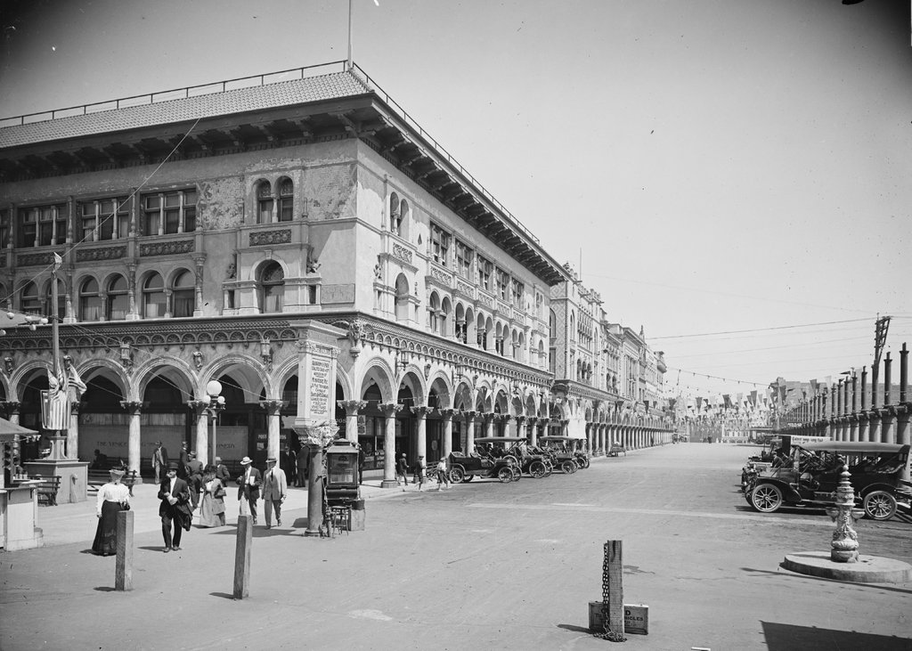
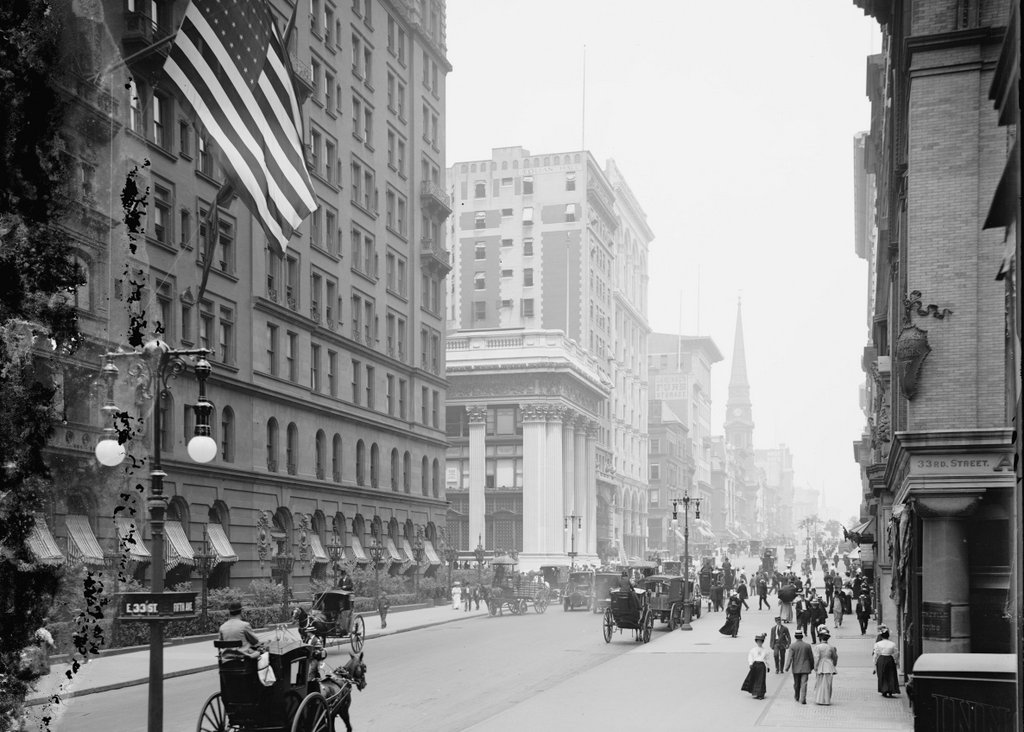
Looking north on Fifth Avenue from 33rd Street, around 1905-1920. Image courtesy of the Library of Congress, Detroit Publishing Company Collection.

917_1905-1920 loc

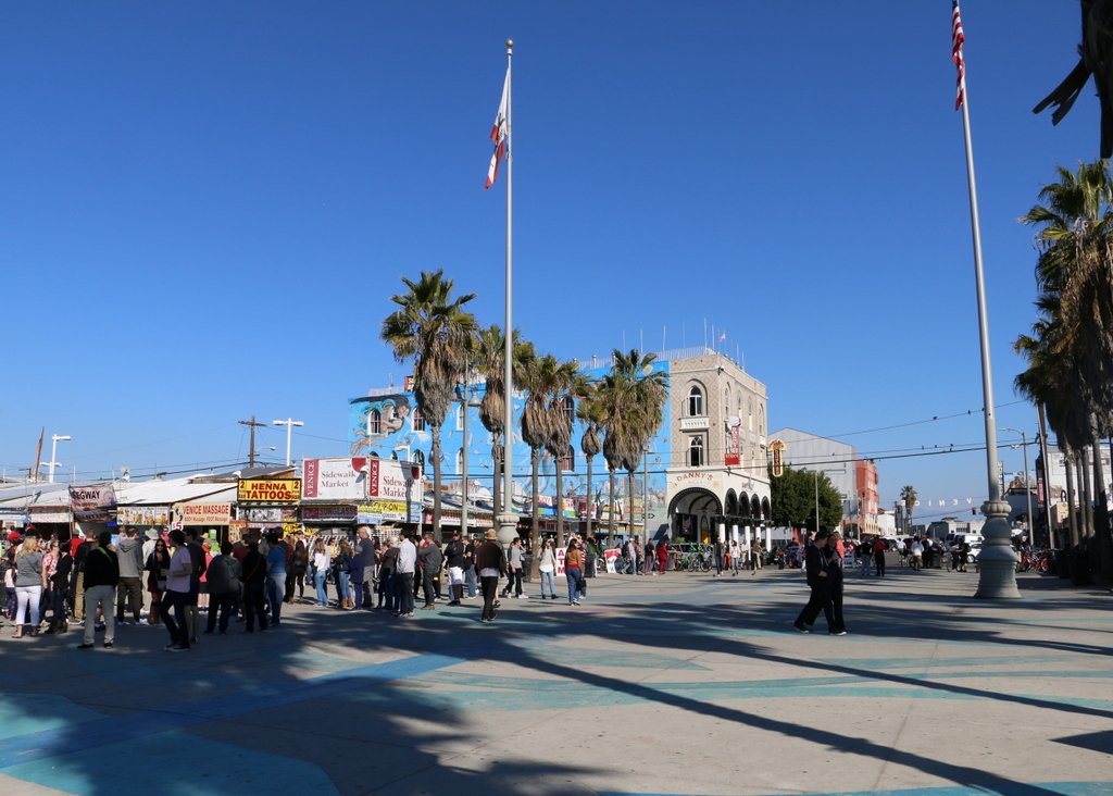
Fifth Avenue in 2016:

917_2016
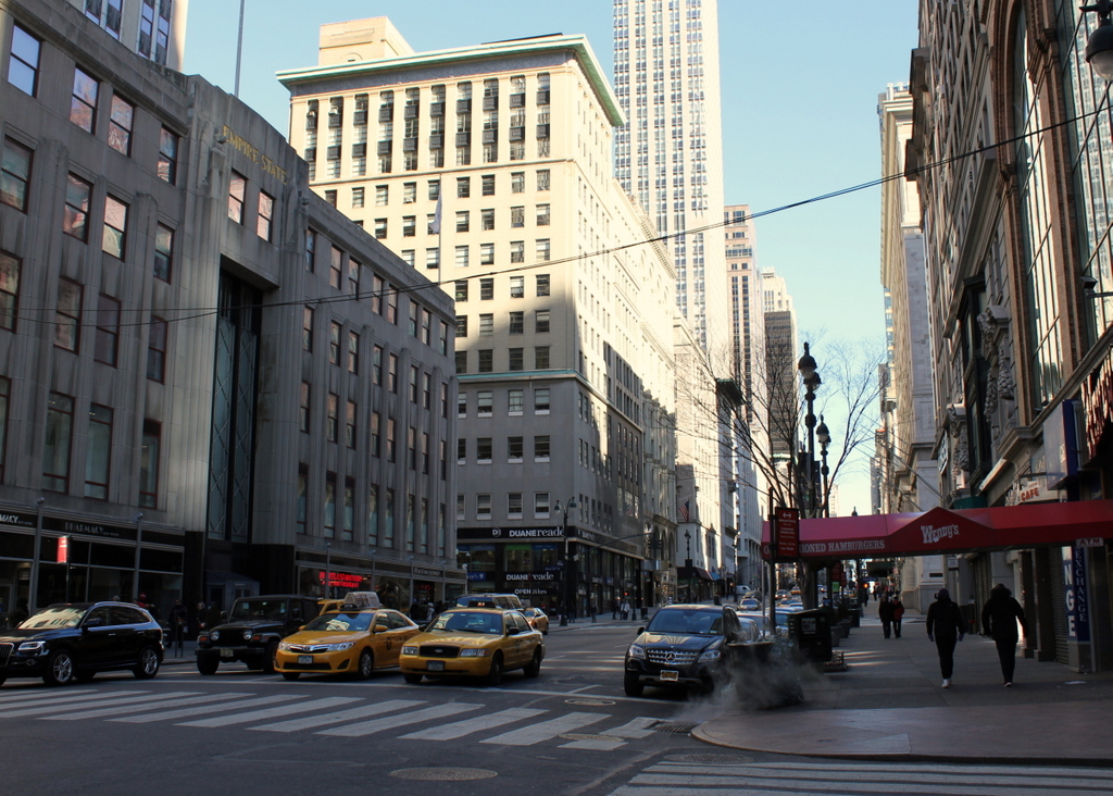
Notice the extremely wide sidewalks in the first photo. Fifth Avenue was originally designed to have a 40-foot roadway with 30-foot sidewalks on either side, but this changed in 1908, shortly after the first photo was taken. To accommodate the growing automobile traffic on the street, it was widened to 55 feet, and the wide sidewalks were trimmed down. Despite over a century of change, though, there are a remarkable number of buildings that have survived from the first photo, especially on the left side. When the first photo was taken, this section of Fifth Avenue had just recently become a major commercial area, and as a result most of the buildings were new at the time.

Perhaps most surprising from the first photo is that the Knickerbocker Trust Company Building – the short building with columns in the center of the photo – is technically still standing, although it has long since been altered way beyond recognition. It was built in 1904 at the corner of Fifth Avenue and 34th Street as the headquarters of one of the nation’s largest banks, but soon after the bank inadvertently played a major role in causing the Panic of 1907. This banking crisis occurred around the time that the first photo was taken, after the Knickerbocker president, Charles T. Barney, attempted to corner the market in copper using the bank’s money. The plan failed, and in the days before FDIC-insured deposits, account holders rushed to the bank to withdraw their money as other banks announced that they would no longer accept checks from Knickerbocker accounts. Ultimately, the bank survived, although Barney was forced to resign and he committed suicide soon after. As for the building, it was significantly changed in 1921 with the addition of ten stories on top of it, and in 1958 the facade was altered to its current appearance, removing any exterior elements from the original structure.

Despite the number of surviving buildings from the first photo, there are several notable ones that have since been demolished. In the distance, at the corner of 37th Street, is the steeple of Brick Presbyterian Church, which was built in 1858 when this area was still largely residential, and it stood there until 1937. Probably the most famous building from the first photo, though, is the Waldorf-Astoria Hotel, on the left side in between 33rd and 34th Streets. This massive hotel is only partially visible in this view, and it stood here until 1929, when it was demolished to build the Empire State Building, which now stands on the site.

Lost New England Goes West: Venice, California

Looking east on Windward Avenue in Venice, around 1912. Image courtesy of the Library of Congress, Detroit Publishing Company Collection.

912_1900-1915 loc

The scene in 2015:

912_2015
Venice was founded in 1905 as a beach resort town just west of Los Angeles. Its developer, tobacco company owner Abbott Kinney, envisioned it as the “Venice of America,” complete with canals, gondolas, and Venetian-style architecture. Among the architectural features in the first photo are the arcades, or arches, along all of the buildings here on Windward Avenue. The building on the left at the corner is the Hotel St. Mark, which was built in 1905, and beyond it are a number of other matching buildings. On the right side, many of the buildings are not yet completed, with a row of columns marking where arches would eventually be built.

When the first photo was taken, Venice had already become a popular tourist destination. The white sign in front of the hotel advertises some of the city’s attractions, including the aquarium on the pier (admission 10 cents), the scenic railway, gondolas and boats on the canals, and the Venice Plunge, which was a heated indoor salt-water pool on one of the piers.

The city was successful in attracting tourists, but politically it was unable to support itself, so in 1926 the residents voted to be annexed by Los Angeles. This brought some major changes, which included filling in most of the canals and building roads on top of them. Venice’s decline continued during and after the Great Depression, and by the 1950s it was in serious decay. The piers were demolished by the 1960s, as were many of the historic buildings here along Windward Avenue and elsewhere in Venice.

Today, Venice is known for its unique countercultural aspects, including artists, street performers, and an inordinate number of medicinal marijuana dispensaries. A number of small shops now occupy the space where the Hotel St. Mark once stood, but a few of the buildings from the first photo still remain, including the one in the center of the photo and another further down Windward Avenue. Over the years, Venice has been used as a filming location for many movies and television shows, several of which feature this particular view here. The opening scene of Orson Welles’s 1958 film Touch of Evil shows the St. Mark a few years before its demolition, and a 2003 episode of Gilmore Girls includes several scenes from this section of Windward Avenue.

This post is part of a series of photos that I took in California this past winter. Click here to see the other posts in the “Lost New England Goes West” series.

Lost New England Goes West: Farmers Market, Los Angeles

The Farmers Market at the corner of 3rd Street and Fairfax Avenue in Los Angeles, around 1953. Image courtesy of the University of Southern California Libraries and the California Historical Society.

911_1953c usc

The view in 2015:

911_2015
The Farmers Market in Los Angeles opened in 1934, and since then it has become a major landmark in the city. Originally, it consisted of a few farmers who parked their trucks here on the property and sold produce, but over the years it grew into a permanent facility as seen in these two photos. The property was owned by Earl Gilmore, the son of Los Angeles oil magnate Arthur F. Gilmore, who also built the nearby Gilmore Stadium and Gilmore Field in the 1930s. The light towers of Gilmore Field can be seen in the distance on the left side of the first photo; it was home to the Hollywood Stars minor league baseball team from 1939 until 1957, and was demolished in 1958 after the Dodgers moved to Los Angeles and brought Major League Baseball to the West Coast.

Because of its proximity to Hollywood, the Farmers Market has attracted its share of celebrities. Around the time that the first photo was taken, stars such as Marilyn Monroe and Ava Gardner as well as Dwight D. Eisenhower all made appearances here, and this trend has continued over the years. Today, the market’s exterior appearance has not changed significantly since the first photo. With a variety of restaurants and other vendors, it is a popular tourist destination, and is in many ways comparable to the much older Quincy Market in Boston.

This post is part of a series of photos that I took in California this past winter. Click here to see the other posts in the “Lost New England Goes West” series.

Lost New England Goes West: Dupont Street, San Francisco

Looking north on Dupont Street (now Grant Avenue) in San Francisco, sometime in the 1850s. Image courtesy of the Library of Congress, Historic American Buildings Survey Collection.

898_1850-1860c loc

Grant Avenue in 2015:

898_2015
This street has been at the heart of San Francisco’s Chinatown neighborhood since the first photo was taken over 150 years ago. Originally named Dupont Street, it soon became a red light district, notorious for its opium dens, brothels, and gang violence. In the background of the first photo is Old Saint Mary’s Cathedral, which opened in 1854 and, as a warning to would-be patrons of the neighborhood, has an inscription below the clock that reads, “Son, Observe the Time and Fly from Evil.”

The 1906 earthquake destroyed the entire street along with the rest of Chinatown, leaving only the burned-out shell of the church still standing from this scene. The disaster gave the city the opportunity to clean up the seedy establishments in the area, and to reflect this change the street was even renamed, to Grant Avenue. The buildings in the foreground of the 2015 scene were probably built in the immediate aftermath of the earthquake, and the old church is partially visible in the distance. The street is still a popular destination in San Francisco, though not for the same reasons in the 19th century; instead of brothels and opium dens, Grant Avenue of today is lined with Chinese restaurants and shops that sell gifts, souvenirs, and jewelry.

Lost New England Goes West: Palace Hotel, San Francisco (3)

The Palace Hotel in San Francisco, seen from the corner of Market, Kearny, and Geary Streets in San Francisco, probably on April 15, 1906. Image courtesy of the Library of Congress.

896_1906c loc


The new Palace Hotel, around 1910-1920. Image courtesy of the Library of Congress, Bain Collection.

896_1910-1920c loc

The hotel in 2015:

896_2015
The first photo here shows the original Palace Hotel as it appeared shortly before it was destroyed in the 1906 earthquake. The caption reads “The Palace April 15. Copyright 1906 Pillsbury Picture Co.”, so it appears to have been taken on April 15, 1906, just three days before the disaster. The hotel had been a San Francisco landmark since its completion in 1875, and as explained in an earlier post it had been specifically designed to withstand both earthquakes and fire. However, while its thick walls survived the earthquake itself, the building was gutted by the subsequent fires, as seen in the first photo of this earlier post, which was taken as the building burned. Yet another previous post, taken from almost the same spot as this April 15 scene, shows the burned-out remains of the hotel and other buildings along Market Street.

Three years later, the hotel was rebuilt on the same site, as seen in the second photo, and it retained its status as one of the city’s premier hotels. Several years after the second photo was taken, President Warren G. Harding died in an eighth-floor suite on this side of the building. He was visiting the city during a tour of the west coast, arriving on July 29, 1923. His health had been rapidly deteriorating amid a busy schedule, and he spent several days in the hotel before his sudden death from an apparent heart attack on August 2.

Today, not much has changed in the “new” Palace Hotel’s exterior appearance. It remains a prominent San Francisco hotel, and the buildings on either side of it are also still standing from the second photo. Market Street is as busy as it was in the early 1900s, and trolleys still run down the middle of the street as they did a century ago. Part of the “F” line of the Muni system, it runs historic streetcars, a few of which date back to the era the second photo was taken. The one in this particular 2015 scene is a PCC streetcar that was built in 1948, making it still far closer in age to the first two photos than to the present-day.

This post is part of a series of photos that I took in California this past winter. Click here to see the other posts in the “Lost New England Goes West” series.

Lost New England Goes West: Stockton Street, San Francisco (2)

Looking north on Stockton Street from Market Street in San Francisco, in the early 1860s. Image courtesy of the Library of Congress, Lawrence & Houseworth Collection.

895_1866c loc

The scene in 2015:

895_2015
The southern end of Stockton Street is here at Market Street, which has been the commercial center of San Francisco since it was first laid out a few years before the first photo was taken. The photo was possibly taken in 1860, because the scene in the foreground appears to show the construction of the Market Street Railway, a horse-drawn trolley system that opened here in 1860. Today, the trolley system is still in place, although this line now operates historic electric streetcars rather than their horse-drawn predecessors.

Today, this section of San Francisco in the vicinity of Union Square is a major shopping district. Nothing is left from the original photo; most of the small two and three story buildings were probably gone before the turn of the 20th century, and anything that would have been left would have been destroyed in the 1906 earthquake. The two photos do have at least one thing in common, though – as in the 1860s view, the 2015 scene also shows a major public transit program in the works. As of 2016, San Francisco is building the Central Subway here, underneath Fourth Street and Stockton Street. The city does not have much in the way of true rapid transit lines, and this subway, which is scheduled to be completed in 2018, will provide much-needed service to the South of Market and Chinatown neighborhoods.

This post is part of a series of photos that I took in California this past winter. Click here to see the other posts in the “Lost New England Goes West” series.