Carew Manufacturing Company, South Hadley, Mass

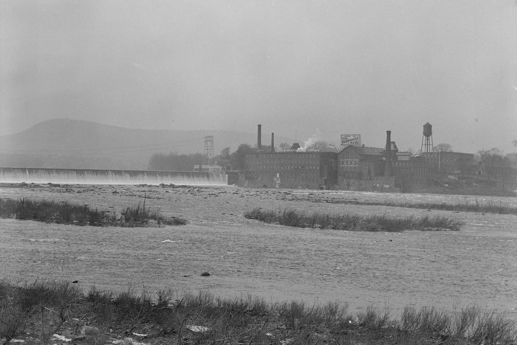
The Hadley Falls Dam and the Carew Manufacturing Company, as seen from the Route 116 bridge over the Connecticut River on the border of Holyoke and South Hadley, in 1936. Image taken by Lewis Hine, courtesy of the U. S. National Archives.
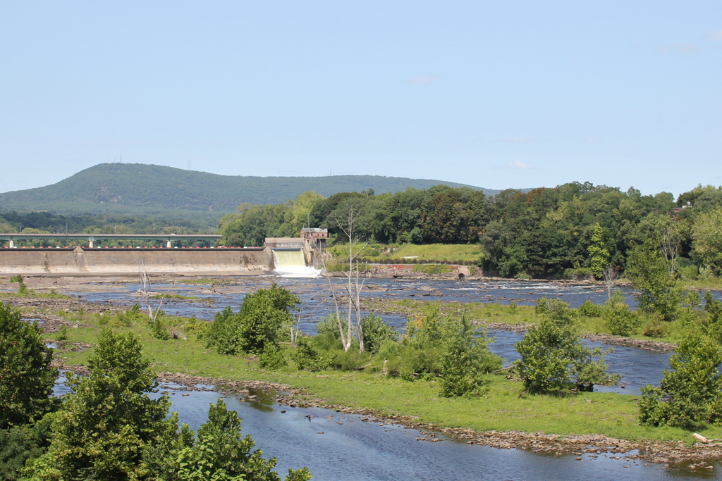
The scene in 2017:

At over 400 miles in length, the Connecticut River is, by far, the longest river in New England, and flows north to south through the region, from the border of Canada all the way to Long Island Sound. It passes over a number of rapids and waterfalls during its course, the largest of which is here on the border of Holyoke and South Hadley, Massachusetts, with a drop of 58 feet. This is also the last major waterfall on the river, and throughout the colonial era it was a major obstacle to river navigation, requiring a costly 2.5-mile portage around the falls.

This problem was partially solved in 1795, when a canal opened on the South Hadley side of the river. It was located on the other side of where the mill buildings stood in the first photo, and it was the first navigable canal in the country, predating longer and more famous ones like the Erie Canal by several decades. However, by the middle of the 19th century, railroads had replaced canals as the most important form of inland transportation, and the South Hadley Canal ultimately closed in 1862.

With the decline of river transportation, along with the rise of industry, this waterfall began to be seen as a major asset, rather than as an obstacle. Industrial development began in the early 19th century, with mills on the South Hadley side, but the most dramatic change to this area came in the the middle of the century. The west side of the river, once a part of West Springfield, was incorporated as Holyoke in 1850, and was developed into a major industrial center. This included the construction of a dam across the river, an extensive power canal system through Holyoke, and a number of large factory complexes.

As a result, Holyoke’s industrial development quickly outpaced that of its older neighbor on the other side of the river. However, South Hadley continued to operate several factories of its own, including two paper mills on the right side of the dam. The one closest to the dam was the Carew Manufacturing Company, and was established in 1848. Its original factory burned in 1873, but it was subsequently replaced by the brick building in the first photo, and produced writing paper for many years. Just to the right of the Carew factory was the Hampshire Paper Company, which was built in the early 1860s and produced the well-known Old Hampshire Bond writing paper.

The first photo was taken in 1936, by prominent photographer and social reformer Lewis Hine. It was in the midst of the Great Depression at the time, and Hine was traveling around the country documenting its effects. He made a visit to Holyoke, where he photographed many of the mills, and he wrote the following caption about this scene:

Mt. Holyoke, Massachusetts – Scenes. The dam: The Connecticut River: the old and famous Hampshire bond manufacturing plant, recently bought by its neighbor, Carew Manufacturing. Also an old and independent mill; founder paternalistic enough to build a church which still stands, enough local feeling to employ from South Hadley because on the Hadley side of the River – Carew Manufacturing Company, 1936

As Hine mentioned in his description, the Hampshire Paper Company closed in 1935, and the property was acquired by the Carew Manufacturing Company. However, the old Hampshire mill was later owned by Stevens Paper Mills, Inc., and it stood here until it was demolished around 1970. In the meantime, the Carew mill was purchased by Texon in 1948, and it produced a variety of goods until it closed in 1986. The property was later sold to Holyoke Gas & Electric, but the historic mill stood vacant for many years before finally being demolished around 2012.

Today, all of the mills from the first photo are gone, but otherwise the scene is still easily recognizable from the first photo. The dam, which was completed in 1900, is still there, and it still provides hydroelectric power for the city of Holyoke. Further in the distance, Mount Tom still forms the backdrop of this scene, although it now features a number of broadcast transmitters atop the 1,202-foot summit. These are hardly visible in the 2017 photo, though, and the only other addition to this scene is the Joseph E. Muller Bridge, which carries U. S. Route 202 across the river just upstream of the dam.

School of the Immaculate Conception of Notre Dame, Holyoke, Mass

The former School of the Immaculate Conception of Notre Dame, on Chestnut Street opposite Hampden Park in Holyoke, around 1892. Image from Picturesque Hampden (1892).

The scene in 2017:

Holyoke grew into a major industrial center during the second half of the 19th century, and the jobs in the mills attracted large numbers of immigrants, particularly the Irish and French Canadians. Most of these immigrants were Catholic, in a region that had previously been almost entirely Protestant, and they soon set about establishing Catholic churches and other religious institutions. The first of these churches was St. Jerome’s, which was established in 1856. Two years later, the parish constructed a church building that still stands at the corner of Hampden and Chestnut Streets, just out of view to the right of this scene.

In 1869, St. Jerome’s Parish opened its first parochial school, the School of the Immaculate Conception of Notre Dame. It was originally an all-girls school, and was located in a wood-frame building that was moved to this site. That same year, the Convent of Notre Dame was completed just to the right of the school. It housed the nuns who taught at the school, and can be seen in the center-right of both photos, with its central tower and Second-Empire style architecture. Then, in 1872, the St. Jerome’s Institute was established as a school for boys, and was located on the other side of Hampden Street, at the corner of Elm Street.

The original Immaculate Conception building was replaced in 1883 by a much more substantial brick school building, which stands on the left side of both photos. It was designed by architect Donat R. Baribault, with an Italianate-style design that included a symmetrical front facade and a tower above the main entrance. By 1890, around the time that the first photo was taken, it had an enrollment of about 550 girls, and the principal of the school was also the sister superior at the adjacent Convent of Notre Dame.

The Immaculate Conception School later became the St. Jerome High School, and in 1963 it merged with several other parish high schools in the city to form Holyoke Catholic High School. The old 1883 school building became part of the Holyoke Catholic campus, and remained in use until 2002, when the school relocated to Granby. Holyoke Catholic has since merged with Cathedral High School in Springfield, and the consolidated school has been known as Pope Francis High School since 2016.

Today, most of the historic 19th buildings from the St. Jerome’s Parish are still standing, including the former Holyoke Catholic buildings. Although they were boarded up for more than a decade after the school moved to Granby, the buildings have since been converted into the Chestnut Park Apartments. This work was completed in 2015, and now there is hardly any difference between these two photos, which were taken 125 years apart. The buildings are now part of the Hampden Park Historic District, which was added to the National Register of Historic Places in 2012.

North Bridge, Salem, Mass

Looking north across the bridge over the North River in Salem, around 1895-1905. Image courtesy of the Boston Public Library.

The scene in 2017:

More than a century before the first photo was taken, this scene on North Street in Salem was the site of Leslie’s Retreat, a confrontation that is said to have been the first armed resistance to British rule in the American colonies. The event occurred on February 26, 1775, less than two months before the more famous battles at Lexington and Concord, and was the result of a British effort to seize cannons that were stored in a blacksmith’s shop on the north side of the river.

On that day, some 240 British soldiers, under the command of Lieutenant Colonel Alexander Leslie, landed in Marblehead and subsequently marched through Salem on their way to the North Bridge. However, by the time they arrived at the south side of the river, the town’s militia had already assembled here, and the drawbridge span had been raised to obstruct their path. Colonel Leslie demanded that it be lowered, and even threatened to open fire if it was not, but the militia stood their ground, their ranks swelled by a growing crowd that shouted insults at the British soldiers.

At one point during the long standoff, the British made an attempt to seize several boats in the river. However, the locals noticed this, and began smashing the bottoms of the boats before the British could reach them. During the ensuing struggle, the soldiers threatened the men with bayonets, but one Salem man, Joseph Whicher, opened his shirt and dared them to stab him. One soldier obliged, lightly pricking him in the chest with his bayonet. It was enough to draw blood, making it arguably the first American blood spilled during the Revolution.

As dusk approached, Leslie realized that the situation was hopeless. He finally reached a compromise with the militia, and was allowed to cross the bridge if he agreed to proceed no further than the blacksmith shop. Everyone on both sides knew that the cannons were long gone by this point, having been removed to a more secure location, but the deal allowed Leslie to save face by technically carrying out his orders. He duly performed a cursory search of the blacksmith shop, found no cannons, and then he and his men marched back to their ship in Marblehead, escorted by local militiamen from all of the surrounding towns.

Although little-known today, this confrontation was an important test of American resolve, and also demonstrated the colonists’ ability to summon large numbers of militiamen at short notice. These same factors were present, on a much larger and bloodier scale, less than two months later, when the British made a similar move to seize military supplies in Concord. Coincidentally, the subsequent battle in Concord also occurred at a bridge known as the North Bridge, and it is that one, as opposed to the North Bridge here in Salem, that has been immortalized as “the rude bridge that arched the flood” where the embattled farmer “fired the shot heard round the world.”

By the time the first photo was taken, the scene had changed significantly from its 18th century appearance. Salem was no longer the prosperous seaport that it had been in the years immediately after the American Revolution, and much of this area along the North River had been developed for industrial use. A few of these industries are visible on the right side of the photo, including the Locke Brothers company, which produced steam fittings in the large three-story building near the foreground. In front of this building is a one-story building that housed the offices of the Collins Brothers coal company, and the coal shed is partially visible on the far right side of the photo.

Today, this scene is essentially unrecognizable from the first photo. Not only are most of the 19th century buildings gone, but the road itself has been completely rebuilt. The river, once been an impassable barrier for the British soldiers, is now hardly even noticeable for modern drivers. However, there are several buildings that appear to survive from the first photo, including one that was likely standing during the events of February 26, 1775. Located at 98 North Street, directly opposite Mason Street, this three-story gambrel-roofed house is barely visible in the distance of both photos, at the point where the road curves out of view. It is now heavily modified from its original appearance, with a storefront occupying part of the ground floor, but it was probably built between 1750 and 1770, making it old enough to have been here when the Leslie’s Retreat occurred.

Dwight L. Moody Gravesite, Northfield, Mass

The graves of Dwight and Emma Moody, at Round Top on the campus of the former Northfield School, around 1910. Image from All About Northfield (1910).

The scene in 2017:

As discussed in the previous post, the 19th century evangelist Dwight L. Moody was born here in Northfield, in a farmhouse that still stands just to the south of here, at the corner of Moody Street and Highland Avenue. Moody lived in Northfield until 1854, when, as a teenager, he moved to Boston and worked in his uncle’s boot and shoe store. He would not return to live permanently in Northfield until 1876, by which point he had become a world-renowned evangelist. He and his wife Emma subsequently purchased a house at the foot of this hill, on Main Street, and they lived there for the rest of their lives. During that time, Moody established the Northfield Seminary for Young Ladies, a private school for girls that was located on a campus behind his house.

Dwight L. Moody died on December 22, 1899, and was buried, in accordance with his wishes, on this knoll, known as Round Top. Located just 300 yards to the north of his birthplace, this spot provides dramatic views of the Connecticut River Valley and the rolling hills of the surrounding countryside. Northfield is located at the tri-point of Massachusetts, New Hampshire, and Vermont, so all three of these states are visible from the hill, although it is the Green Mountains of Vermont that dominate the background of this particular scene. Moody was buried here on December 26, and his grave was marked with a headstone that reads “He that doeth the will of God abideth forever.” His wife Emma died four years later, in 1903, and was buried beside her husband on the right side of the photo, with an inscription on her headstone that reads “His servants shall serve him, and they shall reign for ever and ever.”

In 1912, only a few years after the first photo was taken, the Northfield Seminary acquired a one-quarter ownership of the gravesite, with Moody’s heirs owning the remaining three quarters. The school later merged with the nearby Mount Hermon School for Boys, which had also been founded by Moody, and became the Northfield Mount Herman School. Both campuses continued to be used for many years, but in 2005 the Northfield campus was closed, and most of the property was sold. However, the school still retains its ownership interest in the plot here on Round Top, and very little has changed in this scene more than a century after the first photo was taken.

James Fisk, Jr. Monument, Brattleboro, Vermont

The gravesite of James Fisk, Jr., in Prospect Hill Cemetery on South Main Street in Brattleboro, around 1872-1885. Image courtesy of the New York Public Library.

The scene in 2017:

This ornate marble obelisk marks the final resting place of James Fisk, Jr., a Vermont native who became a prominent Wall Street financier and, in the process, one of the most notorious of the Gilded Age robber barons. Fisk was born in 1835 in Pownal, Vermont, and was the son of James Fisk, Sr., a peddler who sold silk dressed and other high-end dry goods. The family moved to Brattleboro in 1843, and in 1849 the elder James opened the Revere House, which became a successful hotel at the corner of Main and Elliot Street. James, Jr. was about 15 at the time, and he lived in the hotel with his father, his stepmother Love, and his half-sister Mary.

For some time, the younger James worked as a waiter at the Revere House, but in 1850 he quite literally ran away with the circus, joining Van Amburgh’s Mammoth Circus and Menagerie. His flamboyant, outgoing personality was perfectly suited for the circus, although he primarily performed menial tasks like taking ticket, feeding animals, setting up tents, and cleaning cages. However, his time with the circus gave him valuable business experience. When he returned to Brattleboro a few years later, at the age of 18, he joined his father’s peddling business, where he applied some of the techniques he had learned with the circus, including traveling in brightly-colored wagons and wearing fancy clothing.

Fisk’s success as a peddler led to him being hired as a salesman for the Boston-based dry goods firm of Jordan Marsh & Company. However, his career remained unremarkable until the start of the Civil War. In 1861, he traveled to Washington, D.C., where his personality and business skills helped win him lucrative government contracts to provide textiles for army uniforms. He became a wealthy man, largely because of these contracts, but he also profited from the war in less scrupulous ways, including smuggling cotton from the south and selling Confederate bonds to European speculators.

Near the end of the war, Fisk became a stockbroker, and in 1866 he established his own brokerage firm of Fisk & Belden. He worked closely with Daniel Drew and Jay Gould, two of the most ruthless business tycoons of their era. Fisk followed in their ways, teaming up with them to gain control of the Erie Railroad and prevent Cornelius Vanderbilt from adding it to his railroad empire. To do so, the trio issued fraudulent shares of the company, which Vanderbilt purchased in large quantities. He lost a considerable amount of money in the process – over $100 million in today’s dollars – and, despite the fraud, Drew, Fisk, and Gould were able to retain control after bribing the New York state legislature to legalize the fraudulent shares.

A few years later, in 1869, Fisk and Gould would attempt an even more ambitious scheme to corner the gold market. They managed to drive the price as high as $160 per ounce before President Ulysses S. Grant ordered Treasury Secretary George S. Boutwell to release $4 million in treasury gold. The price of gold quickly plummeted, breaking their corner on the market. Fisk and Gould managed to avoid serious financial losses, but many investors were ruined, and the scheme triggered a nationwide economic panic.

Aside from his questionable business practices, Fisk’s personal life also had its share of scandal. He had married his wife, Lucy Moore, in 1854, not long after he left the circus. They remained married even after his rapid ascent from dry goods peddler to Wall Street tycoon, but she spent most of her time in Boston rather than with Fisk in New York. During this time, Fisk had a mistress, the actress Josie Mansfield, whom he housed in a brownstone on 23rd Street in New York. However, after a few years she fell in love with one of Fisk’s business partners, Edward Stiles Stokes, and she began threatening Fisk with blackmail. Fisk refused to pay, and the love triangle eventually led to Stokes shooting Fisk on the staircase of the Grand Central Hotel, in January 6, 1872. Fisk died the following day, at the age of 36, although not before identifying Stokes as the shooter.

Fisk’s body lay in state on January 8, at the Grand Opera House, where around 20,000 mourners came to pay their respects. On Wall Street, Fisk has been a ruthless businessman, but the poor and working-class of New York admired him for his charity work, and many saw him as the typification of the American Dream: a circus laborer and country peddler who rose to greatness through hard work and determination. That night, his body was returned to Brattleboro, where around 5,000 people – equivalent to the town’s entire population at the time – were on hand when the funeral train arrived at almost midnight. His funeral was held the next morning at the Revere House, and then his body was brought here to Prospect Hill Cemetery for burial.

At the time of his death, Fisk’s estate was valued at just under $1 million, or about $20 million today. Of this, $25,000 was spent on a marble obelisk here at his gravesite. It was designed by prominent sculptor Larkin Mead, a Brattleboro native whose other works of this era included Abraham Lincoln’s tomb in Springfield, Illinois. His design for Fisk’s monument included a bas-relief portrait of Fisk in the center, surrounded on all four corners by partially nude female figures. Each figure symbolized trade and commerce in some way, with one representing railroads, another steamships, a third the stage, and the fourth finance.

The first photo was probably taken soon after the monument was installed, because at this point it did not yet include Fisk’s dates of birth or death. His widow, Lucy, outlived him by 40 years, and she was interned here after her death in 1912. Her inscription was added to the base of the monument, and over the years other members of the family were buried here in this plot, as shown by the many gravestones in the present-day photo.

Overall, though, the monument has not aged well. No longer the brilliant white of the first photo, its marble has been weathered and blackened by nearly 150 years of New England’s climate. Along with this, the bas-relief of Fisk was removed in the early 2000s, leaving a faint shadow in the oval. Souvenir hunters have also caused damage over the years, with Fisk’s admirers occasionally chipping off pieces of the marble. However, as one of Fisk’s friends noted many years later, in an excerpt published by Jay Gould biographer Edward J. Renehan, Jr., these visitors “have made the monument more fitted to commemorate Jim’s career – striking from many aspects, picturesque, but blemished.”

Soldiers’ Monument, Brattleboro, Vermont

The Civil War monument and bandstand on the town common in Brattleboro, around 1905. Image courtesy of the Library of Congress, Detroit Publishing Company Collection.

The scene in 2017:

Civil War monuments are a near-ubiquitous feature of almost every town common across the country, and Brattleboro is no exception. Dedicated in 1887, the Brattleboro Soldiers’ Monument has a granite base, with bronze plaques on all four sides and an eight-foot-tall bronze infantryman on top. As indicated on one of the plaques, the monument was to commemorate “the loyalty and patriotism of the men of Brattleboro, who fought for liberty and the union in the great rebellion of 1861-1865.” According to the plaque, the town had a total of 381 residents who served in the war, 31 of whom died.

The monument was built at a cost of $6,000, and the June 17, 1887 dedication ceremony drew a number of dignitaries here to the common. It was presided over by Frederick Holbrook, a Brattleboro native who served as governor for the first two years of the war, and whose father once lived in a house across the street from the common. The dedication speech was given by James R. Tanner, a Civil War veteran who had lost both of his legs at the Second Battle of Bull Run. Tanner was the stenographer who had been summoned to Abraham Lincoln’s deathbed in order to record eyewitness testimonies from the assassination, and he later went on to become Commander-in-Chief of the Grand Army of the Republic, serving from 1905 to 1906. Aside from Holbrook and Tanner, other dignitaries included Governor Ebenezer J. Ormsbee, and Brattleboro resident Colonel George W. Hooker, who was later awarded the Medal of Honor for single-handedly capturing 116 Confederate soldiers during the Battle of Crampton’s Gap in 1862.

The dedication ceremony drew about 5,000 people to the common, but an even larger crowd – estimated at 8,000 – gathered here on September 1, 1902, when Theodore Roosevelt gave a speech during a presidential tour of Vermont. This took place only a few years before the first photo was taken, and Roosevelt spoke from the bandstand in the center of the photo, just to the right of the monument. The president was accompanied by a number of notable Vermonters, including Frederick Holbrook, then-Governor William W. Stickney, federal judge Hoyt H. Wheeler, and U.S. Attorney James L. Martin, whom Roosevelt would later appoint as Wheeler’s successor on the bench. Roosevelt was escorted here from the train station, spoke from the bandstand for about 15 minutes, and was presented with a bouquet of roses. He was then escorted back to the station, and from there he traveled south across the border to Northfield, Massachusetts, where he spent the night at the Northfield Hotel.

Today, more than a century after the first photo was taken, this scene has not significantly changed. The old bandstand was evidently replaced at some point, and a different gazebo now stands on the site. Along with this, the cannon and shot are now gone, and its approximate location is now a picnic table. Otherwise, though, this site continues to be used as the town common, and the Soldiers’ Monument still stands here, now accompanied by a second memorial to the Brattleboro residents who were killed in World War I, World War II, the Korean War, and the Vietnam War.