Halfway House, Mt. Washington, NH

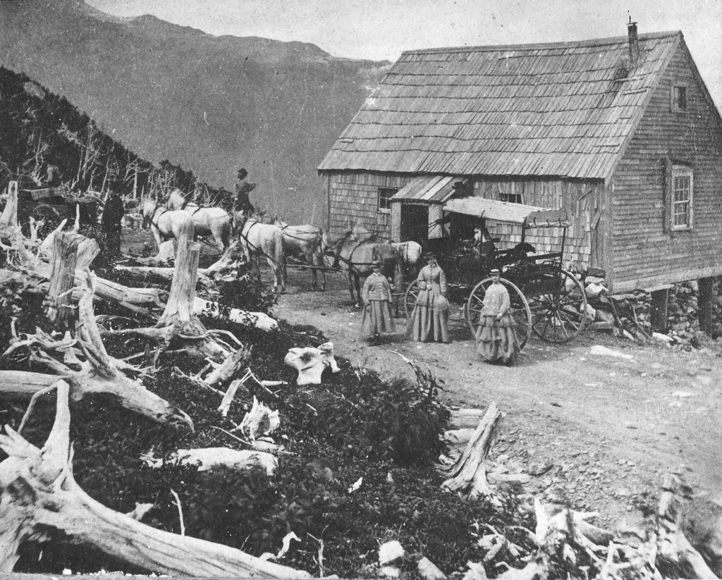
The Halfway House on the Mount Washington Carriage Road in New Hampshire, around the 1870s. Image courtesy of the Mount Washington Auto Road.
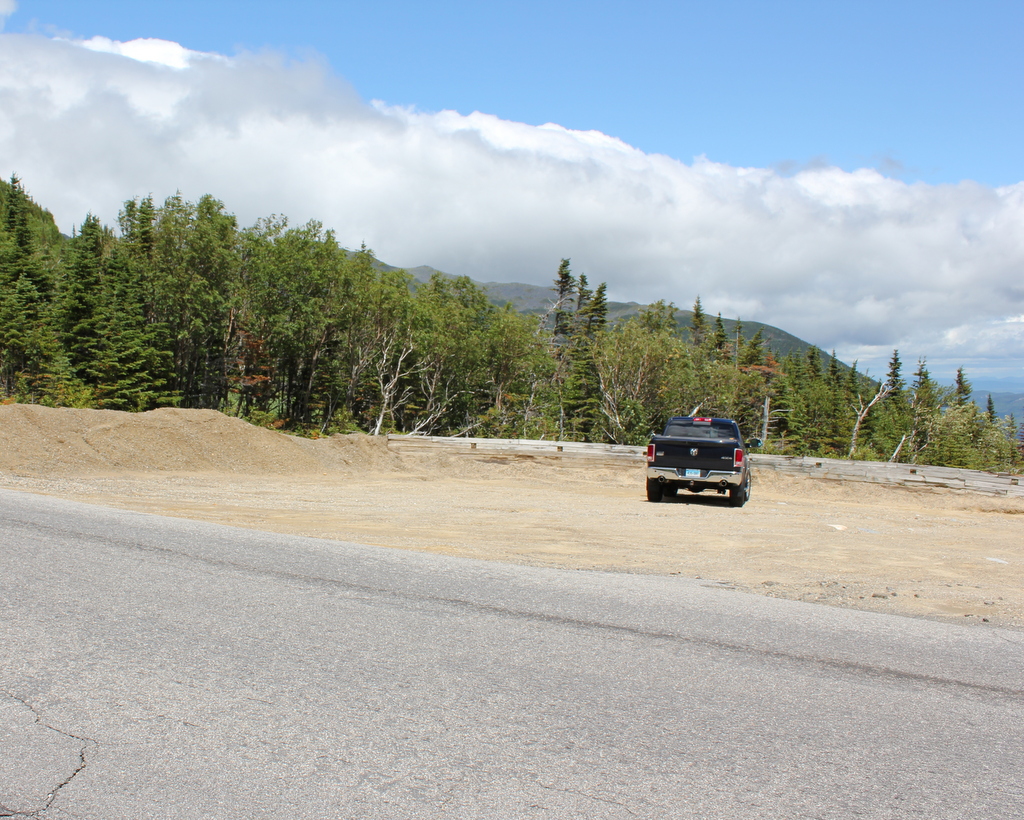
971_1870sc mwar

The scene in 2016:

971_2016
Mount Washington is the tallest peak in the northeastern United States, and it has been a popular tourist destination since the mid-19th century. By the end of the 1860s, the mountain had a hotel at the summit, along with both a cog railway and a carriage road to bring visitors to the top. The nearly eight-mile long carriage road opened in 1861, and this small building along the side of the road served an important purpose for early travelers. Known as the Halfway House, it was located about four miles up the road, hence the name, and it was used as a toll house. It was also a good resting place during the four-hour carriage ride up the mountain, and when necessary its location just below the treeline made it a refuge from the unpredictable and often dangerous weather in the alpine zone.

The building in the first photo was later replaced with a more substantial two-story structure. This one served the same purpose as the original, but over time it suffered from vandalism because of its isolated location, and it was finally destroyed by a fire in 1984. Today, the carriage road is now the Mount Washington Auto Road, and aside from cars replacing horses, not much has changed about the road, which still follows the same route that was laid out in the 1850s. The drive to the summit now takes about 30 minutes, and while the Halfway House no longer stands here, the site is still used as a stopping place. It is no longer necessary to rest horses here, but the climb is still taxing for cars, so the site here is used by drivers heading up the mountain to cool their radiators, and by those heading down to cool their brakes.

Old Burying Ground, Cambridge, Mass

The Old Burying Ground in Cambridge, across from Harvard Yard, around 1899. Image courtesy of the Library of Congress, Detroit Publishing Company Collection.

960_1899c loc

The cemetery in 2016:

960_2016
Cambridge was first settled in 1631, just a year after Boston, at a location a little further up the Charles River from Boston. Originally given the creative name of Newe Towne, the settlement centered around the Harvard Square area, and this was the town’s only cemetery for nearly 200 years. The first burials here date back  to around 1635, but headstones were not common at the time, so the oldest one still standing is dated 1653.

Most of the headstones here are from the late 17th and 18th centuries, with very few after the early 19th century. Because it was the town’s only cemetery, the burials here represent people from all classes and walks of life. Some of the prominent citizens have more elaborate monuments, such as the table stone in the foreground, which marks the grave of Colonel John Vassall, who died in 1747.

Today, the historic gravestone remains essentially unchanged since the first photo was taken some 117 years ago. In the background is Christ Church, one of two churches that borders the cemetery on either end. It was built in 1760, and although partially hidden by trees in the 2016 scene, it is still standing as one of the few surviving works of prominent colonial architect Peter Harrison.

Fort Gilbert Monument, West Brookfield, Mass

The Fort Gilbert Monument at the corner of North Main and Winter Streets in West Brookfield, around 1902-1927. Image courtesy of the Longmeadow Historical Society, Emerson Collection.

956_1902-1927 lhs

The monument in 2016:

956_2016
The town of Brookfield, which originally included present-day North, East, and West Brookfield, was first settled by Europeans in 1660 as the town of Quaboag. At the time, it was in a very isolated location in central Massachusetts, some 25 miles from the towns in the Connecticut River valley and twice as far from Boston and the other towns along the coast. Because of this, it was very vulnerable to an Indian attack, which occurred in 1675 during King Philip’s War. The town was destroyed and abandoned, with many of the settlers moving back to where they had previously lived.

Over a decade later, settlers returned, and this time they came better prepared for potential raids. They built four forts, including Fort Gilbert here in the western part of the town. It included barracks for soldiers and, if necessary during a raid, to house the families of the town, and it was surrounded by a stockade. The fort was still standing during the French and Indian War, although it was far removed from any battles, and some of its remains were still visible well into the 19th century.

Today, any evidence of the fort is long gone, but the site is marked with this simple monument, which was put here around 1900. It is located in a small park next to the West Brookfield Elementary School, on North Main Street just west of the town common.

Town Green, Longmeadow, Mass

Facing north on the Town Green in Longmeadow, on July 5, 1903. Image courtesy of the Longmeadow Historical Society, Emerson Collection.

946_1903-07-05 longhs

The Green in 2016:

946_2016
Longmeadow’s Town Green is a historic district on the National Register of Historic Places, and it is surrounded by a number of buildings dating back to the 18th and 19th centuries. There have been some changes since the first photo was taken, particularly to the church and its parsonage. The church, surprisingly, is the same one from the first photo, just with some significant alterations, and the parsonage is the same building, just in a different location. It is located in about the center of the 1903 photo, just north of Williams Street, but it was moved to the other side of the church around 1921, where it is visible on the far right in the 2016 photo. The large Colonial Revial-style Community House, which was built on the old site of the parsonage in 1921, is the newest building in this scene and the only one that does not appear in the 1903 photo.

Columbus Circle, New York City

Looking north at Columbus Circle, with the statue of Christopher Columbus in the foreground, around 1900. Image courtesy of the Library of Congress, Detroit Publishing Company Collection.

935_1900c loc

Columbus Circle in 2016:

935_2016
Not much has remained the same at Columbus Circle since the first photo was taken; even the configuration of the circle itself has seen some dramatic changes. The one constant in both photos, though, is the Christopher Columbus monument in the center of the circle. It was designed by sculptor Gaetano Russo and dedicated in 1892 in honor of the 400th anniversary of Columbus’s voyage. When the first photo was taken, it was easily the most prominent landmark in the scene, but today it has a backdrop of high-rise buildings along Broadway and Eighth Avenue, including the Trump International Hotel and Tower, located directly behind the monument in the 2016 photo.

Lost New England Goes West: Santa Monica, California (2)

Another view looking north from the pier in Santa Monica, around 1910-1930. Image courtesy of the University of Southern California Libraries and the California Historical Society.

914_1910-1930c usc

The view in 2015:

914_2015
Like the view in the previous post, these two photos show some of the changes that have happened along the beach in Santa Monica over the years. The most prominent building in the first photo here is the Windermere Hotel, visible in the upper center of the photo. It was built in 1909 and was demolished in 1962 to build Pacific Plaza, the tall apartment building that stands on the site today. Just to the left of it in the 2015 view is the Georgian Hotel, which was built in 1933 by the owners of the Windermere, probably only a few years after the first photo was taken.

This post is the last in a series of photos that I took in California this past winter. Click here to see the other posts in the “Lost New England Goes West” series.