Washington Square North and Mall Street, Salem, Mass

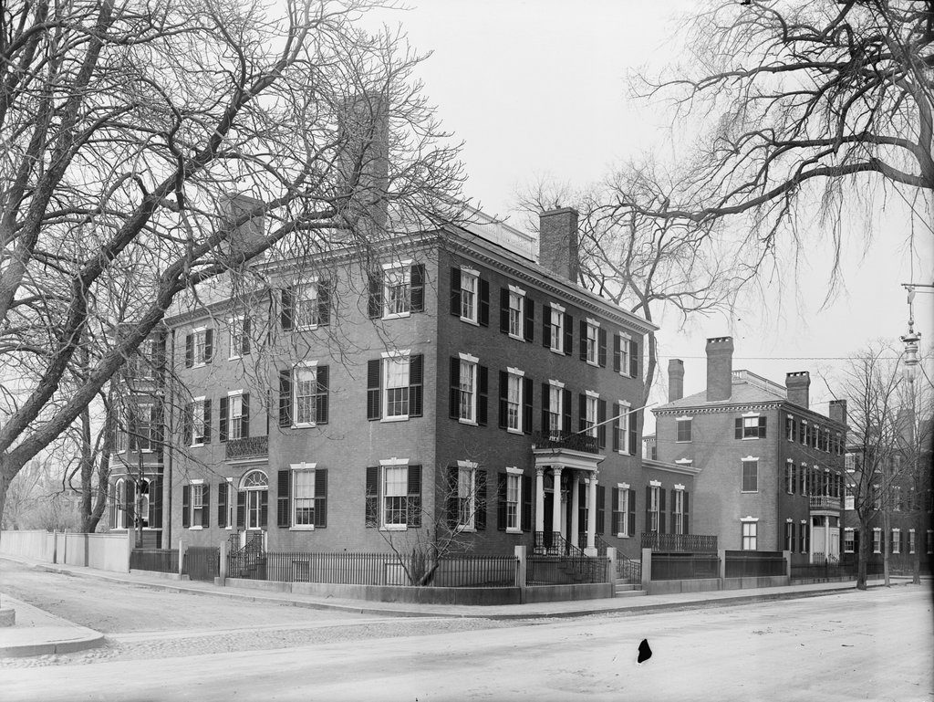
The northeast corner of Washington Square North and Mall Street in Salem, around 1910. Image courtesy of the Library of Congress, Detroit Publishing Company Collection.
The scene in 2017:
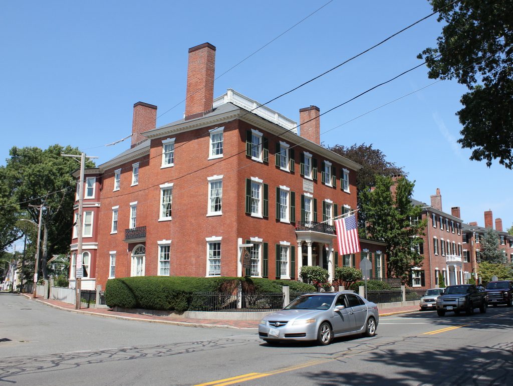
This scene shows a row of three elegant Federal-style brick homes that were built along the north side of the Salem Common in the early 19th century. The houses were originally owned by three wealthy merchants, each of whom married a daughter from the prominent Story family. Starting in the foreground, at the corner of Mall Street, 29 Washington Square North was built in 1818-19 as the home of John Forrester and his wife, Charlotte Story. Beyond it, house number 31 was built in 1811 for Stephen White and his wife Harriet Story, and furthest in the distance is house number 33, which was also built around 1811 and was the home of Joseph White, Jr. and his wife Eliza Story.

Charlotte, Harriet, and Eliza were all daughters of Dr. Elisha Story, a noted physician who had been a member of the Sons of Liberty and had participated in the Boston Tea Party. He became an army surgeon after the start of the American Revolution, including seeing combat at the Battle of Bunker Hill, and after his service in the Continental Army he practiced medicine for the rest of his life. He had eight children – one of whom died soon after birth – with his first wife Ruth, and eleven with his second wife Mehitable, including the three sisters who lived in these houses. Another child from this second marriage was Joseph Story, a lawyer who went on to serve on the U. S. Supreme Court from 1812 to 1845.

In 1810, Charlotte Story married John Forrester, who was the son of prominent merchant Simon Forrester and the first cousin of author Nathaniel Hawthorne. John received a substantial inheritance after his father’s death in 1817, and he soon began building the house in the foreground of the scene. The old house on this site – itself a fine mansion – was relocated to 91 Federal Street, where it still stands today, and construction of the new house was underway by June 1818. It was nearly finished by September of the following year, when prominent local pastor William Bentley described it in his diary, writing:

Capt. John Forrester is now preparing the front of his house on the north side of the Common, with a southern front. He has the best situation. Everything is well done about this house which will soon be ready for him. It comes nigher in its appearance to our usual style of building in brick, but probably is not behind in any of the materials or workmanship upon the plan he has adopted.

John and Charlotte Forrester moved into the house in December 1819, along with their five children. They would go on to have five more children, and they lived here in this house until 1834. By this point, John had suffered a significant reversal of his fortune, with business failures that forced the family to sell the house and move into decidedly more humble quarters around the corner at 9 Oliver Street. John died three years later, but Charlotte outlived him by 30 years, living in Salem until her death in 1867.

In the meantime, the house just beyond the Forrester house was, for many years, the home of Charlotte’s sister Harriet and her husband Stephen White. They were married in 1808, and moved into this house upon its completion three years later, where they raised their four children. Stephen White was a prominent merchant who was also involved in politics. He held a number of elected offices throughout the 1820s, including serving in the state House of Representatives in 1821 and 1828; the state Senate in 1825, 1826, and 1830; the Governor’s Council in 1824; and as a presidential electors in 1828. He was also a personal friend of Daniel Webster, and his daughter Caroline later married Webster’s son Fletcher. Aside from Webster’s other prominent visitors to this house included President James Monroe, who attended a reception here on July 11, 1817. Reverend Bentley also described this event in his diary, writing:

[I]n the evening [Monroe] was at Capt. Stephen White’s & there was received by a very brilliant assembly of Ladies, who were attended by The gentlemen of the Town. As this would probably be the last interview, it collected more than any former one but with less comfort from over stowing. The President however may have done too much as he hardly had time to breathe. But the question was everywhere, have you seen him? And this eager curiosity it would have been cruel to indulge & even gratify. I presented him the Gold headed walking Cane of the late Gen. Knox, Sec. of War, & the very elegant Tobacco box of Silver, with a wrought China top, received from China.

Stephen White lived in this house on Washington Square North throughout the 1820s. His wife Harriet died in 1827 at the age of 40, and around 1831 he moved to Boston. By this point Salem had already peaked in its prosperity as a major port, and it would continue to decline throughout the 19th century, while Boston enjoyed steadily growing wealth and population. White sold his Salem mansion in 1831 for $7,000 – only about $160,000 in today’s dollars – and lived in Boston until his death a decade later in 1841, at the age of 54.

The house furthest in the distance of both photos, at 33 Washington Square North, was built around 1811, the same year as Stephen White’s house, and was even constructed by the same builder, Joshua Upham. It was originally the home of Stephen White’s older brother, Joseph White Jr., and his wife Eliza Story, who was the older sister of Stephen’s wife Harriet. Joseph was a merchant, and he was named after his uncle, Joseph White, Sr., a wealthy merchant who was the victim of an infamous 1830 murder in Salem. However, the younger Joseph did not live long enough to see this happen; he died in 1816, only a few years after his house was completed, leaving his widow Eliza and three young daughters. She lived here in this house until 1831, when she sold the property and joined her brother-in-law Stephen in moving to Boston.

Overall, despite their wealth and prominence, the Forrester and White families’ ownership of these houses was marked by catastrophic business failure and untimely deaths. However, the houses would continue to be home to some notable Salem residents of the mid and late 19th century, including Colonel George Peabody, who purchased John Forrester’s house in the foreground in 1834. He was about 30 years old at the time, and was the son of wealthy Salem merchant Joseph Peabody. He would go on to have a successful business career as well, including serving as president of the Salem Bank and the Eastern Railroad. Along with this, he was a colonel in the militia, and served several terms as a city alderman. Peabody lived here until his death in 1892, and during this time he had several prominent visitors to the house, including poets Henry Wadsworth Longfellow and James Russell Lowell, biologist and geologist Louis Agassiz, and Civil War General George McClellan.

By the time the first photo was taken around 1910, the Forrester-Peabody House was used as the home of the Salem Club, a private men’s club. Around the 1920s, it became the Bertram Home for Aged Men, as indicated by the panel that is now located above the second floor window in the present-day scene. The house was renovated in 1990, becoming an assisted living facility, and it is still in use today as the John Bertram House. However, despite these many changes in use, the exterior of the house has remained well-preserved in more than a century since the first photo was taken, and the only notable change is the panel on the front facade.

Just beyond this house, Stephen White’s former house changed hands several times in the mid-19 century. Merchant John W. Rogers lived here from 1831 to 1844, followed by another merchant, Thomas P. Pingree, who lived here from 1844 to 1858 before selling it to attorney Nathaniel Lord. It would remain in his family for the next 90 years, until it was finally sold in 1948. However, like its neighbors, this house is also well-preserved today, with no significant differences between the two photos.

The house of Joseph White, Jr., on the far right of both photos, was owned by the prominent Silsbee family from 1831 until the early 1880s, and its residents included merchant and banker Benjamin H. Silsbee, who was the president of the Merchants’ National Bank in Salem. Later in the 1880s, the house became the parsonage for the Tabernacle Congregational Church. Its pastor at the time was DeWitt S. Clark, a native of Chicopee, Massachusetts who began his ministry at the Salem church in 1878. His father had been the longtime pastor of the First Congregational Church in Chicopee, and DeWitt Clark had a similar tenure here in Salem. He was still serving as pastor when the first photo was taken around 1910, and that year’s census shows him living here with his wife Emma and their four children. Reverend Clark died in 1916, but his family later purchased the house and continued living here for many years, eventually selling the property in 1969.

Today, almost two centuries after William Bentley described the finishing touches on the Forrester House in his diary, this scene has hardly changed. Although no longer inhabited by prosperous merchant families, these three houses are among the many fine early 19th century homes that still stand in Salem,and serve as reminders of the city’s golden age as one of the wealthiest communities in the country. All three houses, along with the rest of the surrounding neighborhood, are now part of the Salem Common Historic District, which was added to the National Register of Historic Places in 1976.

North Bridge, Salem, Mass

Looking north across the bridge over the North River in Salem, around 1895-1905. Image courtesy of the Boston Public Library.

The scene in 2017:

More than a century before the first photo was taken, this scene on North Street in Salem was the site of Leslie’s Retreat, a confrontation that is said to have been the first armed resistance to British rule in the American colonies. The event occurred on February 26, 1775, less than two months before the more famous battles at Lexington and Concord, and was the result of a British effort to seize cannons that were stored in a blacksmith’s shop on the north side of the river.

On that day, some 240 British soldiers, under the command of Lieutenant Colonel Alexander Leslie, landed in Marblehead and subsequently marched through Salem on their way to the North Bridge. However, by the time they arrived at the south side of the river, the town’s militia had already assembled here, and the drawbridge span had been raised to obstruct their path. Colonel Leslie demanded that it be lowered, and even threatened to open fire if it was not, but the militia stood their ground, their ranks swelled by a growing crowd that shouted insults at the British soldiers.

At one point during the long standoff, the British made an attempt to seize several boats in the river. However, the locals noticed this, and began smashing the bottoms of the boats before the British could reach them. During the ensuing struggle, the soldiers threatened the men with bayonets, but one Salem man, Joseph Whicher, opened his shirt and dared them to stab him. One soldier obliged, lightly pricking him in the chest with his bayonet. It was enough to draw blood, making it arguably the first American blood spilled during the Revolution.

As dusk approached, Leslie realized that the situation was hopeless. He finally reached a compromise with the militia, and was allowed to cross the bridge if he agreed to proceed no further than the blacksmith shop. Everyone on both sides knew that the cannons were long gone by this point, having been removed to a more secure location, but the deal allowed Leslie to save face by technically carrying out his orders. He duly performed a cursory search of the blacksmith shop, found no cannons, and then he and his men marched back to their ship in Marblehead, escorted by local militiamen from all of the surrounding towns.

Although little-known today, this confrontation was an important test of American resolve, and also demonstrated the colonists’ ability to summon large numbers of militiamen at short notice. These same factors were present, on a much larger and bloodier scale, less than two months later, when the British made a similar move to seize military supplies in Concord. Coincidentally, the subsequent battle in Concord also occurred at a bridge known as the North Bridge, and it is that one, as opposed to the North Bridge here in Salem, that has been immortalized as “the rude bridge that arched the flood” where the embattled farmer “fired the shot heard round the world.”

By the time the first photo was taken, the scene had changed significantly from its 18th century appearance. Salem was no longer the prosperous seaport that it had been in the years immediately after the American Revolution, and much of this area along the North River had been developed for industrial use. A few of these industries are visible on the right side of the photo, including the Locke Brothers company, which produced steam fittings in the large three-story building near the foreground. In front of this building is a one-story building that housed the offices of the Collins Brothers coal company, and the coal shed is partially visible on the far right side of the photo.

Today, this scene is essentially unrecognizable from the first photo. Not only are most of the 19th century buildings gone, but the road itself has been completely rebuilt. The river, once been an impassable barrier for the British soldiers, is now hardly even noticeable for modern drivers. However, there are several buildings that appear to survive from the first photo, including one that was likely standing during the events of February 26, 1775. Located at 98 North Street, directly opposite Mason Street, this three-story gambrel-roofed house is barely visible in the distance of both photos, at the point where the road curves out of view. It is now heavily modified from its original appearance, with a storefront occupying part of the ground floor, but it was probably built between 1750 and 1770, making it old enough to have been here when the Leslie’s Retreat occurred.

Washington Street, Salem, Mass

Looking north on Washington Street from the corner of Essex Street in the center of Salem, around 1906. Image courtesy of the Library of Congress, Detroit Publishing Company Collection.

The scene in 2017:

One of the great features of Salem is its remarkably well-preserved downtown area, with hundreds of historic buildings that date as far back as the 17th century. Here in the center of the city, both Washington Street and Essex Street are lined with historic commercial blocks, although this particular view of Washington Street does not have very many buildings that survive from the first photo. In fact, the only building that is easily identifiable in both photos is the Neal and Newhall Building on the far right. This was built in 1892 at the northeast corner of the intersection, and is still standing with few significant changes except for the ground floor storefront and the balustrade atop the roof.

The other buildings beyond the Neal and Newhall Building on the right side of the street are still standing from the first photo, although it is hard to tell from this angle. These include, starting in the foreground, the Newhall Annex (c.1902), City Hall (1837), and the Kinsman Block (c.1882). However, on the more visible left side of the street, not much remains from the first photo. In the distance, near the center of the photo, is the Tabernacle Congregational Church, which was built in 1854 and demolished in 1922 to build the current church building on the site. Next to the church, barely visible at the base of the steeple, is the Odell Block, which was built in 1890. This three-story brick commercial block is the only building on the left side of the first photo that has survived largely unaltered.

The only other building on the left side of the street that apparently still stands today is the one on the left side, with the American flag flying above it in the first photo. This was the home of the William G. Webber dry goods business, and the signs on the building advertise for other tenants such as the New York Life Insurance Company and the Merchants National Bank. It was known as the Endicott Building, and its National Register of Historic Places listing indicates that it was built in 1885 and remodeled in 1911. However, the first photo shows a date of 1872, which suggests that it was actually a little older. The 1911 renovations apparently altered most of the original exterior, though, and the building went through even more dramatic changes in recent years, adding several stories to the top of the original building, and today there are no visible remnants from its original turn-of-the-century appearance.

Belcher Memorial Fountain, Northfield, Mass

The Belcher Memorial Fountain, at the corner of Warwick Road and Main Street in Northfield, around 1910. Image from All About Northfield (1910).

The scene in 2017:

The first photo was taken within about a year of the installation of the Belcher Memorial Fountain, which was originally placed in the center of Warwick Road, at the corner of Main Street. The 16-foot-tall, 27.5-ton granite fountain was given to the town as a bequest from Mary and Eliza Belcher. The two elderly sisters never married, and were the last living members of the Belcher family in Northfield. They both died in 1907, seven months apart from each other, leaving money to the town to build a fountain here in the center of town, which was dedicated on September 14, 1909.

Aside from the fountain, the first photo shows two buildings in the background on Main Street. On the left is the Unitarian Church, which was built in 1871 to replace an earlier church building that had burned. It was the work of noted Worcester architect Elbridge Boyden, and features a Gothic Revival-style that was popular for churches of the era. Contrasting with the ornate style of the church is the modest Webster Block on the right. This two-story, wood-frame commercial building was built in the late 1800s, and housed a variety of businesses over the years, including a drugstore, a grocery store, a shoe store, and the village post office.

Today, this scene has not changed significantly. Both the church and the Webster Block are still standing, and neither have had any major alterations. The only real change between the two photos is the fountain itself, which was moved a short distance to the south of here in 1960 and now stands next to the town hall. Although originally intended to provide water for horses, as the first photo shows, this purpose became obsolete as cars replaced horse-drawn vehicles. The fountain likely became a hazard to vehicles, since it sat in the middle of the intersection, and it was subsequently replaced with a small traffic island marked by a flashing light.

Chapin Street, Brattleboro, Vermont

Looking east on Chapin Street, from the corner of Oak Street in Brattleboro, around 1894. Image from Picturesque Brattleboro (1894).

The scene in 2017:

Chapin Street was developed in the mid-1880s, less than a decade before the first photo was taken. The street, which runs one block from Oak Street to Linden Street, was built through land that had once belonged to Dr. Charles Chapin, who lived in a house at the end of the road on Linden Street. Chapin was a Harvard-educated physician, but he was also a businessman who served as a state legislator, a U.S. Marshal, and a director of the Vermont Mutual Insurance Company and the Vermont Valley Railroad. He lived here until his death in 1875, and his wife Sophia died five years later.

Soon after Sophia’s death, the property was sold and subdivided. The old house survived, and still stands today, but the rest of the land became building lots for new houses. The new street was named in honor of Chapin, and was developed around the same time as Williston Street, which runs parallel to Chapin Street on land once owned by merchant Nathan B. Williston. Both streets featured ornate, Queen Anne-style homes, most of which were completed by the time the first photo was taken in the early 1890s. A streetcar line was also built on the street in the 1890s, although this apparently happened after the first photo was taken.

The first photo shows a few people walking along an otherwise quiet residential street. In the foreground, three women walk arm-in-arm along the sidewalk, while a man walks further in the distance. On the left side of the street, a boy appears to be sitting on some sort of a bicycle, and far in the distance a pair of horses are harnessed to a wagon. In the distance, beyond the newly-built homes, is the northern slope of Mount Wantastiquet, which forms a scenic backdrop for much of downtown Brattleboro.

Today, most of the houses are hidden by trees from this view, but all of the ones from the first photo appear to still be standing. Chapin Street remains a well-preserved example of a late 19th century middle class neighborhood, and the houses still retain their decorative exterior designs with multi-colored paint schemes. The street itself has changed somewhat over the years, though. The trolley tracks have come and gone, the street has been widened and paved, and the sidewalk on the left is gone, but overall the scene is still easily recognizable from the first photo.

Flat Street, Brattleboro, Vermont

Looking east on Flat Street in Brattleboro, around 1894. Image from Picturesque Brattleboro (1894).

The scene in 2017:

During the second half of the 19th century, Brattleboro became an important manufacturing center, thanks in large part to the water power provided by the fast-moving Whetstone Brook. Much of the town’s industrial development was centered along this brook, including here on Flat Street, which runs along its northern banks. At the time that the first photo was taken, the properties on both sides of the street were owned by George E. Crowell, a prosperous businessman who lived in a large mansion to the northwest of here, at the corner of High and Green Streets. The right side of the street included a cabinet shop, which appears to have been the building on the far right. Further beyond this building, out of view in the first photo, was a carriage shop as well as the Brattleboro Jelly Company, which produced cider jelly and cucumber pickles.

The most visible building in the first photo was the six-story Carpenter Organ Company building. Built around the mid-1860s for the Brattleboro Melodeon Company, this factory was purchased about 20 years later by the Carpenter Organ Company, which still occupied the building when the first photo was taken. At the time, organ manufacturing was a major part of Brattleboro’s economy, and Carpenter was one of several such companies in the town. George Crowell was one of the owners of this company, but he sold his interest in 1914. By then, pump organs were falling out of fashion, and the company only remained in business for a few more years, closing around 1917.

Today, there is nothing remaining in this scene from the first photo, except for Flat Street itself. The old Carpenter Organ building is long gone, as are all of the other industrial buildings on either side of the street. Like most of the other old New England mill towns, there is very little manufacturing left in Brattleboro, and it has been many decades since any organs were produced in the town. The site of the Carpenter factory is now a parking garage, disguised to make its exterior resemble an old brick mill. On the other side of the street, parking lots are now located where the cabinet shop, carriage shop, and jelly company used to be, although at least one of the historic factory buildings on Flat Street – the C. F. Church building – has since been converted into commercial use, and is located just out of view to the right of the 2017 photo.