School Street, Boston

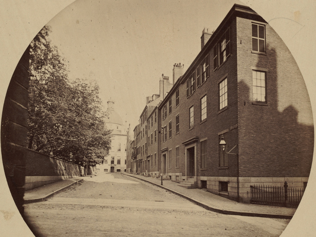
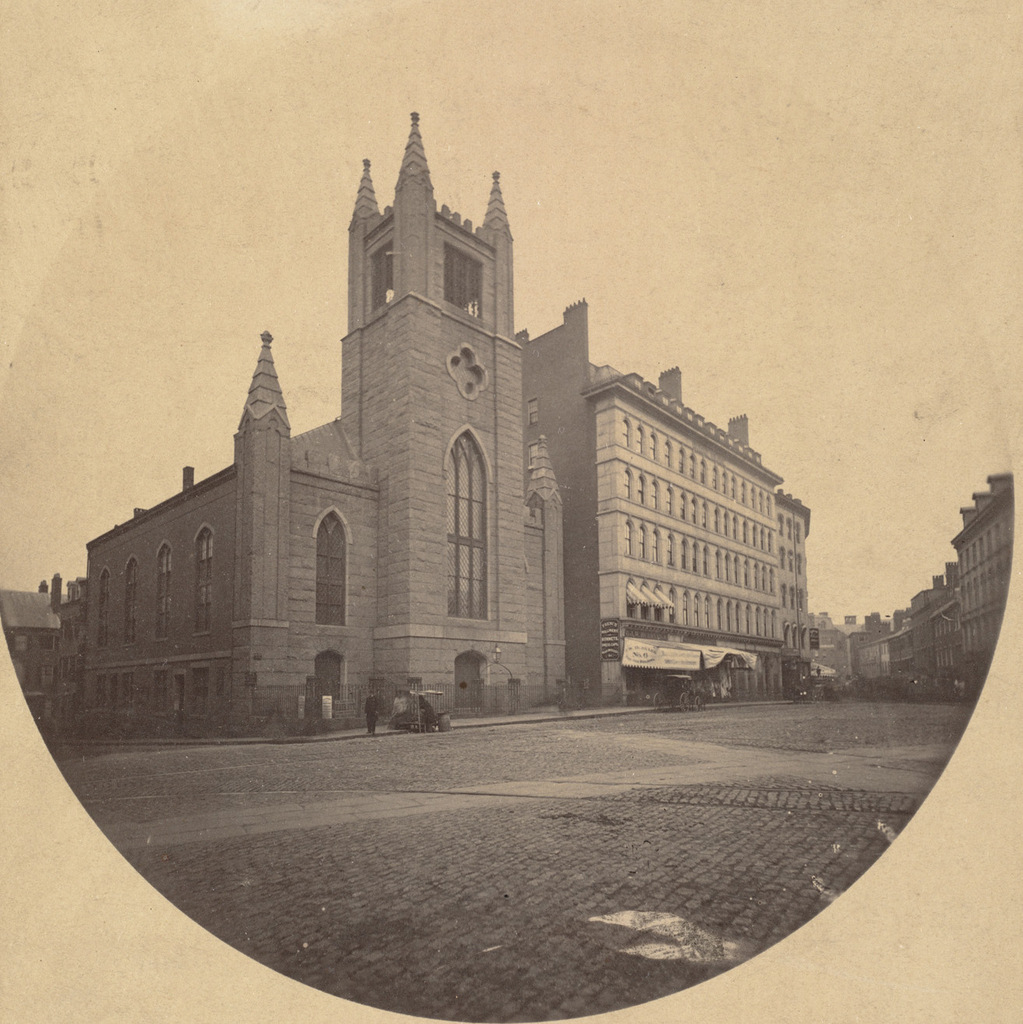
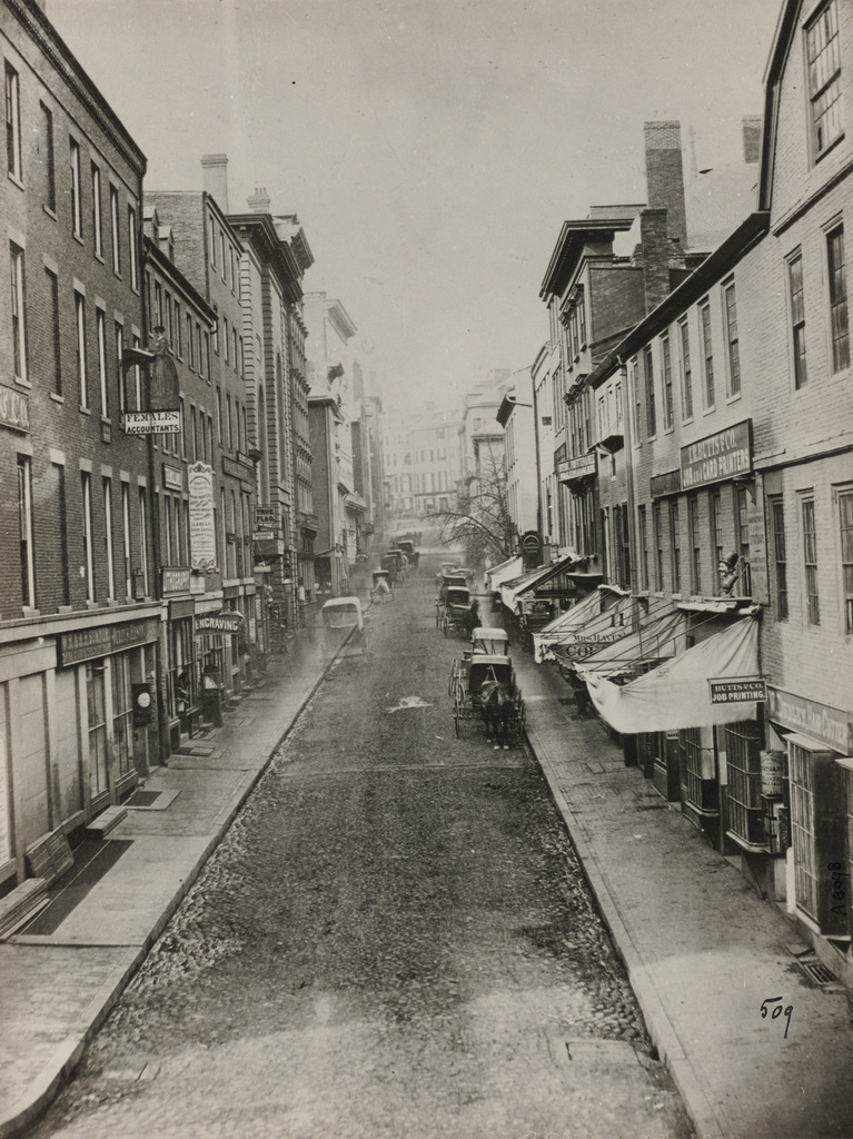
Looking up School Street from Washington Street in Boston, around 1860. Image courtesy of the Boston Public Library.

832_1860c bpl

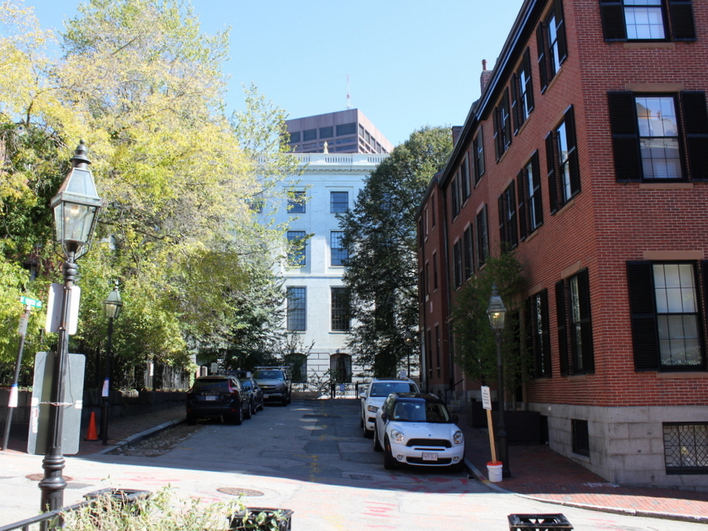
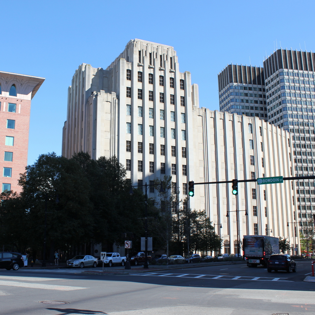
School Street in 2015:

832_2015
School Street is only a couple hundred yards long, yet this narrow downtown street has been home to a number of historic sites. The entire street is part of the Freedom Trail, and notable sites along here include King’s Chapel at the Tremont Street end and the Old Corner Bookstore on the right, here at the Washington Street end. In between, opposite Province Street, were two generations of Boston City Hall buildings, built on the former site of the Boston Latin School. The street is named for this school, which was here from 1704 to 1748, and during that time educated future Founding Fathers such as Benjamin Franklin, John Hancock, Samuel Adams, and Robert Treat Paine. Another School Street landmark, which has long since been demolished, was the original Parker House hotel, which was built in 1855 and is barely visible in the distance on the left side, on the site of the present Omni Parker House. A couple notable guests who visited the hotel not long after the first photo was taken included John Wilkes Booth, who stayed here eight days before assassinating Abraham Lincoln, and Charles Dickens, who lived here for five months in 1867-1868 during his tour of the United States.

The School Street that Charles Dickens would have seen was a narrow, busy street, and today not much has changed in that regard. In fact, the 1860 scene was probably busier than it appears. There are no pedestrians visible, which was probably due to the photographer using a long shutter speed, but in all likelihood there were plenty of people walking around at the time. None of the buildings are still standing from the first photo, though, except for the barely-visible King’s Chapel in the distance and the Old Corner Bookstore on the far right. The original part of the bookstore was built in 1712, and it was expanded up School Street in 1828 with the construction of the two three-story brick buildings on the right.

Mount Vernon Place, Boston

Mount Vernon Place, seen from Joy Street in Boston around 1860. Image taken by Josiah Johnson Hawes, courtesy of the Boston Public Library.

829_1860 bpl

Mount Vernon Place in 2105:

829_2015
Mount Vernon Place is a short street in Boston’s Beacon Hill neighborhood, located just west of the Massachusetts State House. It was once a full block long, and was developed in the 1830s on land that had once been owned by John Hancock and his family. As the 1860 photo shows, the street had a small park on the left side and eight townhouses on the right, and at the end of the street was the State House. The five houses closest to the State House were demolished in the 1910s when the building was expanded, and today only the three in the foreground survive. These three were built around 1833-1834, and have been largely unaltered on the exterior since then. They are among the many historic early 19th century townhouses that have become a defining feature of Beacon Hill, and they form a part of the Beacon Hill Historic District on the National Register of Historic Places.

Beacon Hill Reservoir, Boston

The reservoir atop Beacon Hill in Boston, around 1860. Image taken by Josiah Johnson Hawes, courtesy of the Boston Public Library.

828_1860 bpl

The scene in 2015:

828_2015
Long before the Wachusett and Quabbin Reservoirs, Boston’s municipal water supply was Lake Cochituate, a reservoir in Natick, Framingham, and Wayland. The project began in 1845, and it included not only creating the artificial lake, but also building a 14-mile long aqueduct that fed this stone reservoir atop Beacon Hill, just behind the Massachusetts State House. From here, the water was distributed throughout the city, using the hill’s elevation to carry the water downhill through the pipes. It occupied the majority of the block between Hancock, Derne, Temple, and Mt. Vernon Streets, and it had a capacity of over 2.6 million gallons.

The structure’s cornerstone laying ceremony in 1847 included a time capsule, which contained several publications and two silver plates, perhaps in the hope that, like the great Roman aqueducts in Europe, this public water supply structure would last for thousands of years. However, as it turned out, it lasted for less than 40. It closed by about 1880, and around three years later it was demolished to build a large expansion of the Massachusetts State House, which now occupies the site where this reservoir once stood.

Bowdoin Square Baptist Church, Boston

The Bowdoin Square Baptist Church in Boston, around 1860. Image taken by Josiah Johnson Hawes, courtesy of the Boston Public Library.

825_1860c bpl

Bowdoin Square in 2015:

825_2015
This scene shows Bowdoin Square facing the opposite direction from the one in the previous post, facing east on Cambridge Street toward Government Center. The most prominent building in the first photo is the Bowdoin Square Baptist Church, a Gothic Revival style church that was built in 1840. Its design is very similar to several other churches that were built in Boston around the same time, including the old Trinity Church on Summer Street and the nearby Bowdoin Street Congregational Church, which is still standing today as the Saint John the Evangelist Mission Church.

The church here at Bowdoin Square gained some notoriety in 1885, when the congregation split after the pastor, William W. Downs, was found in what was alleged to be a “compromising position” with a woman from his church. The scandal was well-publicized in newspapers across the country, and the church split into two factions, with one supporting his removal and the other believing his claims that he was the victim of a conspiracy. He was eventually dismissed from his position, and the church closed, but he maintained his innocence and several years later won a lawsuit against his accusers, with the jury awarding him $10,000 in damages.

Following the Downs scandal, the church became the Bowdoin Square Baptist Tabernacle, and it was extensively remodeled on the exterior and interior in 1898. However, the church sold the building in 1916 to the New England Telephone and Telegraph Company. Around 1930, they demolished the church and the neighboring Coolidge Building to the right, in order to build their new Boston headquarters, which is still standing in the 2015 photo. None of the other buildings remain from the 1860 photo, either; most of this section of Boston was demolished in the 1950s and 1960s as part of the West End and Government Center urban renewal projects.

Scollay Square, Boston

Scollay Square, looking north from the corner of Tremont and Court Streets, sometime in the 1860s. Image courtesy of the Boston Public Library.

823_1860-1869c bpl

Scollay Square on August 26, 1897. Image courtesy of the City of Boston Archives.

823_1897_08_26 coba

Scollay Square around 1942. Image courtesy of the Boston Public Library, Leslie Jones Collection.

823_1942c bpl

The scene in 2015:

823_2015
These four photos reveal the dramatic transformations that have occurred at Boston’s Scollay Square over the past 150 years. The square once included a long, narrow row of buildings in the middle, which appear on city maps as early as the 1720s. The construction date for the building in the first photo is unknown, but it was once at the southern end of this row, and in 1795 it was purchased by William Scollay, a real estate developer for whom the square would eventually be named. By the time the first photo was taken, all of the other buildings in the middle of the square had been demolished, and Scollay’s building was taken down soon after, around 1870.

The second photo shows a very different scene. Some of the buildings along the square are still standing, but the Scollay Building is gone, as are the horse-drawn trolleys from the first photo. Instead, they have been replaced by electric trolleys, like the one shown in the photo. However, these would not last long, at least not on the surface. The second photo was taken only about a week before the Tremont Street Subway opened, and the photo shows some of the construction activity as the workers prepared the Scollay Square station for its opening day on September 3. The station itself is not visible, but its ornate entrance can be seen in this post, which shows the scene from a slightly different angle.

Scollay Square had long been a major commercial center in the city, but by the time the third photo was taken in the 1940s, it had seen a dramatic decline. Many of the old buildings were still standing, but the businesses had become seedier. The 1942 photo shows a number of bars, liquor stores, cheap restaurants, and burlesque theaters, and the area was particularly popular among sailors on leave from the Boston Navy Yard and college students from the many nearby schools. One prominent hotel and theater in both the second and third photos was the Crawford House on the far right. It was built in 1865 and underwent several renovations, including one in 1926 that completely altered the front. The building burned in 1948, and all but the first two floors were demolished a few years later.

By the 1950s, the area was being targeted for urban renewal. Looking to replace the area with something more respectable, the Boston Redevelopment Authority demolished over a thousand buildings in the vicinity to build the Government Center complex, which includes the Center Plaza to the left, the John F. Kennedy Federal Building in the center, and the Boston City Hall, just out of view to the right. The old Scollay Square subway station was also extensively renovated and renamed Government Center. When the last photo was taken, the station was undergoing a another renovation, so if there is one thing that the second and fourth photos have in common, it is subway station construction.

Devonshire and Water Streets, Boston

The northwest corner of Devonshire and Water Streets in Boston, around 1860. Image courtesy of the Boston Public Library.

821_1860c bpl

The scene in 2015:

821_2015
Based on its architecture, the building in the first photo was probably built sometime around the 1820s to the 1840s, and by the 1860s when the photo was taken it appears to have been a place for all things paper. According to the signs, the tenant on the left was a job printing company, which was a collective term for a printer who made small items such as tickets, cards, letterheads, and other such documents. To the right was Peter C. Jones’s wholesale paper business, which he operated in Boston for many years. He had four sons, so I don’t know which one was the “& Son” that is mentioned on the sign, but it certainly was not his son Peter, Jr., who moved to Hawaii in 1857 and became a prominent businessman and politician both before and after the kingdom was acquired by the United States.

I don’t know exactly when this building was demolished. The great Boston Fire of 1872 hit this area 12 years later, but according to maps of the disaster, the fire stopped just across the street from here. If this building was still standing at that point, it probably survived the fire, but it was certainly gone by 1908, when the present-day Lawrence Building was built on the site. When completed, it housed the Federal Trust Company commercial bank on the ground floor, and professional offices such as lawyers, investment brokers, and real estate agents. Today, the historic building is still standing here at the corner of Devonshire and Water Streets.