Crawford Notch, Hart’s Location, New Hampshire

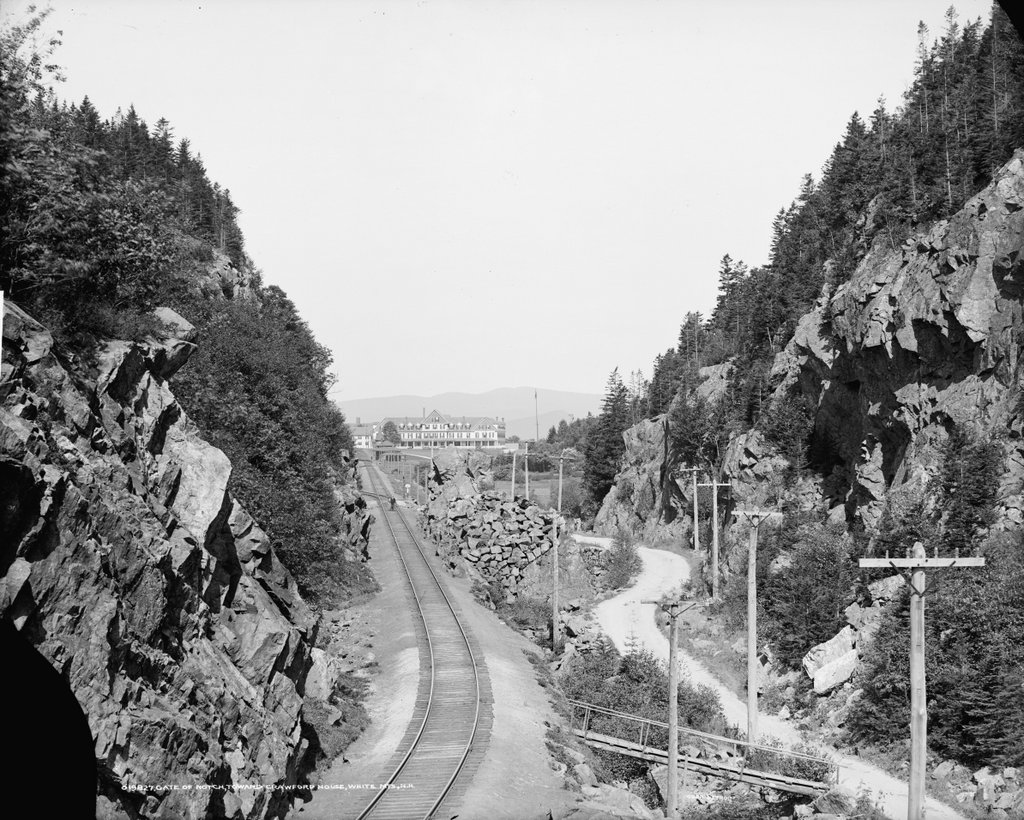
The view looking northwest through Crawford Notch in the White Mountains of New Hampshire, around 1860-1875. Image courtesy of the New York Public Library.

The same view around 1907. Image courtesy of the Library of Congress, Detroit Publishing Company Collection.

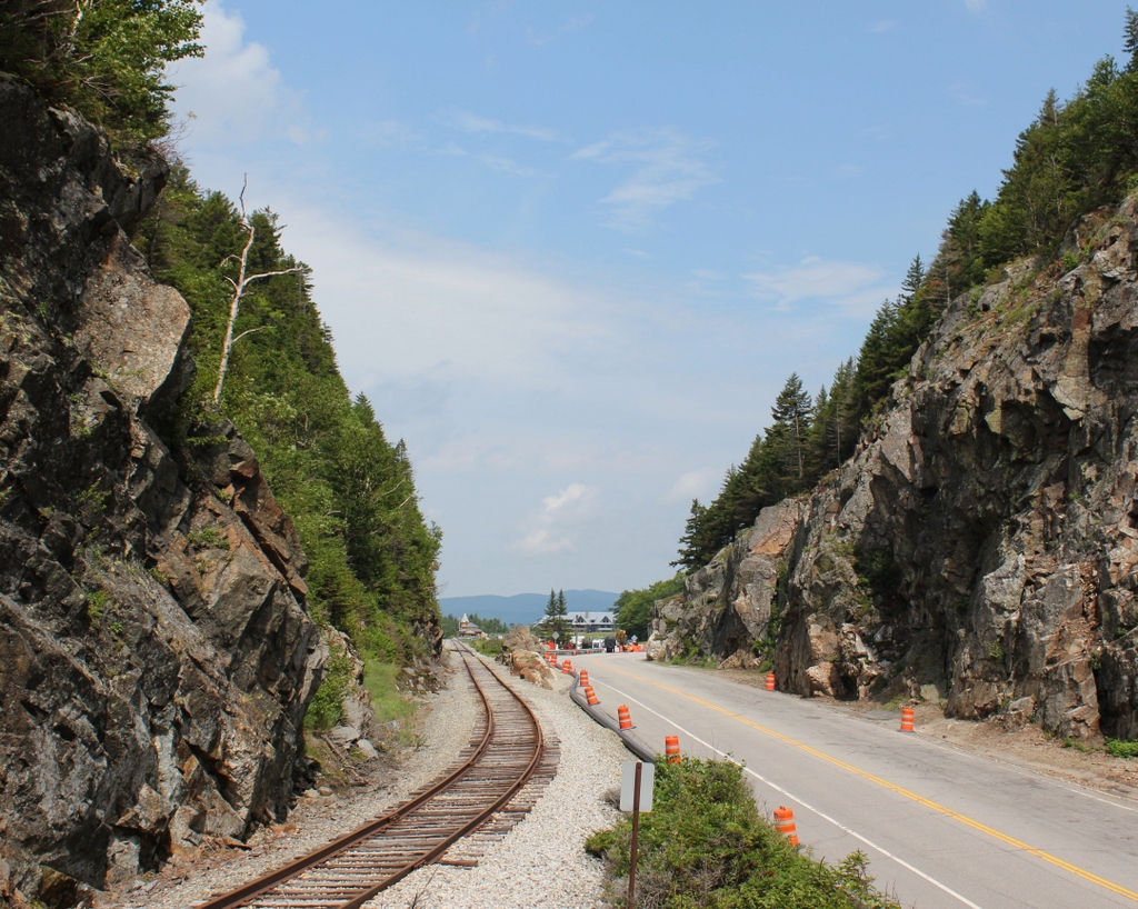
The scene in 2018:

Crawford Notch is an important mountain pass within the White Mountains of New Hampshire. Until the completion of the Kancamagus Highway in the 1960s, it was the only east-west route through the mountain range, and over the years it has served as a major link between northern Vermont and the coastal region of southern Maine. The notch consists of a narrow valley that is several miles in length, but the actual mountain pass is here at the northern end of this valley, at a gap in the mountains that was originally barely 20 feet wide. This spot came to be known as the gate of the notch, because of the high rocks that stand on either side of the pass.

The highest point of Crawford Notch is just to the north beyond the gates, in the distance of this scene. At 1,900 feet in elevation, it forms the divide between the Ammonoosuc River, which flows west to the Connecticut River and then to Long Island Sound, and the Saco River, which flows east through Crawford Notch and then to Maine, where it empties into the Atlantic Ocean just south of Portland. To the northeast of here is the Presidential Range, which begins here at the Notch and reaches its highest point, Mount Washington, about 6.5 miles from here. In the opposite direction, to the southwest of the notch, is the Peimgewasset Wilderness, the largest wilderness area in the state.

The first recorded discovery of Crawford Notch occurred in 1771, when Timothy Nash and Benjamin Sawyer came across it while hunting. As the story goes, Nash had become lost while tracking a moose. He climbed a tree in order to get his bearings, and in the process he sighted the gates here at the northern end of the notch. The notch had long been known to Native Americans, but Nash and Sawyer were evidently the first Europeans to find it, and within a few years there was a rough road through here.

The notch was ultimately named in honor of the Crawford family, who became the first permanent settlers of the area. Around 1790, Abel Crawford built a house a little further to the north of here, where he remained for several years before selling it to his father-in-law, Eleazer Rosebrook. Crawford then moved to the southern end of the notch, around the site of the present-day town of Hart’s Location.

Both he and Rosebrook operated inns for travelers, and Crawford helped to pioneer tourism to the White Mountains region. After Rosebrook’s death in 1817, Abel’s son Ethan Allen Crawford inherited the property here at the notch. Two years later, the Crawfords constructed an 8.5-mile trail from the notch to the summit of Mount Washington, and provided guided trips for visitors. Now known as the Crawford Path, it is considered to be the oldest continuously-used hiking trail in the country, and it has been incorporated into the Appalachian Trail.

One early visitor to this region was Timothy Dwight IV, a prominent author and theologian who served as president of Yale from 1795 to 1817. He came to the Notch on at least two separate occasions, and provided a description of it in his book Travels in New England and New York. In this particular visit, he approached the notch from the north, facing the opposite direction of these photos, and he wrote:

The entrance of the chasm is formed by two rocks, standing perpendicularly at the distance of twenty-two feet from each other: one about twenty feet in height, the other about twelve. Half of the space is occupied by the brook, mentioned as the head stream of the Saco; the other half by the road. The stream is lost, and invisible, beneath a mass of fragments, partly blown out of the road, and partly thrown down by some great convulsion.

When we entered the Notch we were struck with the wild and solemn appearance of every thing before us. The scale, on which all objects in view were formed, was the scale of grandeur only. The rocks, rude and ragged in a manner rarely paralleled, were fashioned and piled on each other by a hand, operating only in the boldest and most irregular manner. As we advanced, these appearances increased rapidly. Huge masses of granite, of every abrupt form, and hoary with a moss which seemed a product of ages, recalling to the mind the “Saxum vetustum” of Virgil, speedily rose to a mountainous height. Before us, the view widened fast to the south-east. Behind us, it closed almost instantaneously; and presented nothing to the eye but an impassable barrier of mountains.

The first photo was taken more than a half century after Dwight wrote this account, but the notch still had much of the same rugged appearance that he would have seen. The road had been improved somewhat over the years, starting in 1806, when the Tenth New Hampshire Turnpike opened through the notch. By the late 1820s, the road was suitable for stagecoaches, but when the first photo was taken around the 1860s or 1870s, this section of the road still looked like a narrow dirt path through the wilderness.

Aside from the road, the only sign of civilization in the first photo is the Crawford House, which is barely visible in the distant center. The original Crawford House was built here in the early 1850s, but it burned in 1859. The hotel was quickly rebuilt on the same site, reopening later in 1859. This new building can be seen in both the first and second photos, and it stood here until it too was destroyed by a fire in 1977. The site of the hotel is now the Highland Center, a lodge and education center operated by the Appalachian Mountain Club.

Perhaps the most dramatic change in this scene occurred shortly after the first photo was taken, when a railroad was constructed through here. The first railroad across the continent had been completed in 1869, and by this point there was even a cog railway to the summit of nearby Mount Washington. However, it would take several more years for railroad engineers to conquer Crawford Notch. The project required several long trestles and deep rock cuts, along with the widening of the gap here at the gates of the notch. The grade of the railroad was also a challenge, with northbound trains having to ascend 1,623 feet in just 30 miles, but the Portland & Ogdensburg Railroad was ultimately completed through the notch in 1875.

In addition to improving transportation through northern New England, the railroad also provided passenger service to the heart of the White Mountains, making it easier for tourists to visit the region. Several of the grand hotels along the route even had their own stations, including the Crawford House, whose station is barely visible in the distance on the right side of the tracks in the second photo. This particular station building had been constructed in 1891, several years after the Maine Central Railroad acquired the Portland & Ogdensburg, and it is still standing today as the only surviving structure from the second photo.

In more than a century since the second photo was taken, the road through the notch has been widened and straightened. It has come a long way since the dirt path of the first photo, and it is now designated as U.S. Route 302, which runs from Portland, Maine to Montpelier, Vermont. Today, it remains as important a route through the White Mountains as it had been when the first road was constructed through here in the 18th century. In that sense, the road has actually outlived the railroad, which was abandoned by Maine Central’s successors, Guilford Transportation, in 1983. However, this section of railroad was ultimately acquired by the Conway Scenic Railroad, which operates excursion trains for tourists. The railroad also owns the station here in the distance, and it serves as the northern terminus for most of its trains.

Today, the White Mountains are still a popular tourist destination, and Crawford Notch is still a major focal point within the region. Most of the notch is within the town of Hart’s Location (population 41 as of 2010), but the northern border of the town is here at the gates of the notch, so the buildings in the distance are actually within the town of Carroll. The land on the Carroll side of the border is still privately owned, but the Hart’s Location side is part of the 5,775-acre Crawford Notch State Park. This park is, in turn, mostly surrounded by the much larger White Mountains National Forest, which covers more than 750,000 acres in New Hampshire and Maine.

Woronoco House, Westfield, Mass

The Woronoco House on Elm Street in Westfield, around the 1860s. Image from Picturesque Hampden (1892).

The scene in 2018:

The Woronoco House was an important hotel here in Westfield throughout much of the 1800s. It was built at some point early in the century, and it stood on the west side of Park Square in downtown Westfield. It was brick, three stories in height, with a distinctive two-story porch here on the Elm Street side. The hotel could accommodate between 80 to 100 guests, and the building also included a tavern, in addition to a barber shop that was marked by a tall striped pole on the left side of the first photo.

The hotel was a stagecoach stop in the years before the railroad, and it also served as a gathering place for locals, ranging from the farmers who lived in the villages on the outskirts of town, to the wealthy cigar and whip manufacturers who dominated the local economy of the mid-19th century. During this time, the Woronoco House also saw a number of notable guests from out of town. These included author Bayard Taylor, Senator Charles Sumner, zoologist and anthropologist Paul Du Chaillu, abolitionist Wendell Phillips, New-York Tribune editor Horace Greeley, Governor John A. Andrew, and politician Edward Everett, who served variously as governor, senator, ambassador to the United Kingdom, and secretary of state.

In 1871, the Woronoco House property was sold for $25,000, and the new owners soon made significant changes to the building. The original structure was evidently retained, but the exterior was completely reconstructed, including the removal of the porches. At some point, probably as part of this renovation, a fourth floor was added to the hotel, and the original gable roof was replaced by a flat roof. Upon completion, the hotel reopened as the Wilmarth House, but it was renamed again in 1886, becoming the Park Square Hotel.

The hotel remained in use well into the 20th century. It underwent another renovation in 1914, and was subsequently rebranded the New Park Square Hotel. However, the building was completely destroyed by an early-morning fire on December 7, 1942. It was one of several catastrophic fires in downtown Westfield during the mid-20th century, and it took firefighters some 13 hours to extinguish the blaze.

There were 35 guests in the hotel at the time of the fire, some of whom appear to have been long-term residents. Four of them were survivors of the fatal 1936 Van Deusen Inn fire, which had killed seven people, but everyone safely escaped from the New Park Square Hotel. One of the survivors of both fires was Minnie Hutchinson, who was carried out of the building by Deputy Chief Joseph Guinasso. Coincidentally, he was the same firefighter who had rescued her from the Van Deusen six years earlier.

The hotel proved to be a total loss, but firefighters were able to prevent the fire from spreading. Aside from minor smoke and water damage, the buildings on either side of the hotel survived largely unscathed. Today, the site of the hotel is now a parking lot, but these two neighboring buildings are still standing. On the left is the former Westfield Cooperative Bank, and on the right is the Snow and Hays Block. This building dates back to 1813, and was probably built around the same time as the Woronoco House, although it has been significantly altered over the years. As shown in the first photo, it was once four stories in height, but it was trimmed down to two stories in the 1940s. However, it survives as the only remnant from the first photo, and it is one of the oldest commercial buildings in downtown Westfield.

Congress Hall, Philadelphia, Pennsylvania

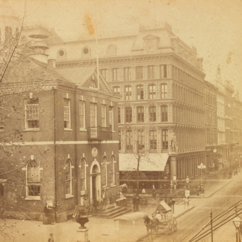
The view looking west on Chestnut Street, toward the corner of 6th Street in Philadelphia, around the late 1860s or 1870s. Image courtesy of the New York Public Library.

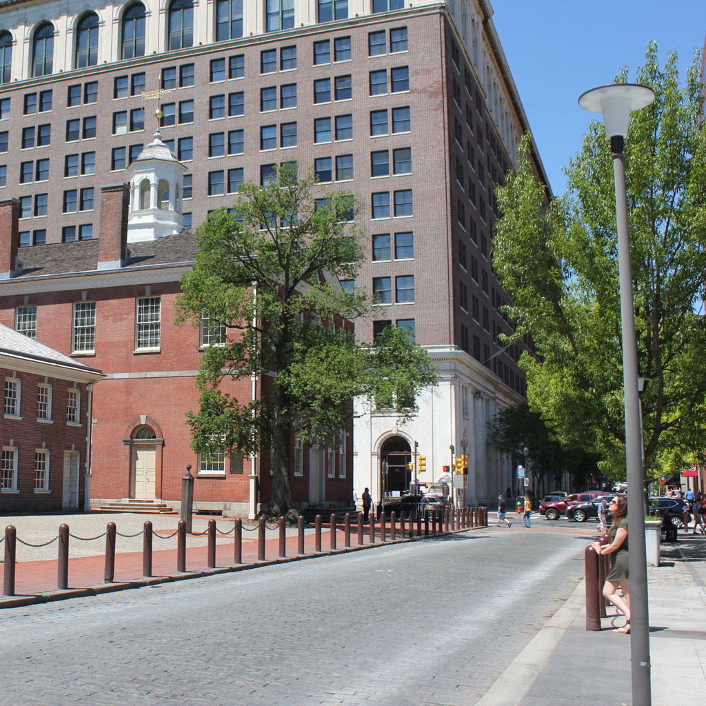
The scene in 2018:

The building on the left side of this scene is Congress Hall, which stands just to the west of Independence Hall on Chestnut Street in Philadelphia. Although smaller and less well-known than its neighbor, this building played an important role in the early history of the United States government, housing Congress for ten years from 1790 until 1800, when the national capital moved to Washington, D.C.

Philadelphia had been the de facto capital city throughout the American Revolution, with the Continental Congress meeting in Independence Hall from 1775 until 1783. However, Congress fled the city in 1783, after being threatened by a mob of soldiers who were demanding payment for their wartime service, and it subsequently met in Princeton, Annapolis, and Trenton, before eventually moving to New York City in 1785. New York served as the capital for the next five years, but Pennsylvania’s inability to protect Congress from rioters had convinced the federal government that it needed a capital city that was not within any state.

In 1790, Congress passed the Residence Act, which established Washington, D.C. as the permanent national capital, but designated Philadelphia as a temporary capital for the remainder of the 18th century. The building here on the left side had been completed a year earlier, in 1789, and it was originally intended as the Philadelphia County Courthouse. It was the work of architect Samuel Lewis, and its brick exterior reflected Federal-style architecture, which was popular during this period, particularly for public buildings. On the interior, the entire ground floor was occupied by the House of Representatives chamber, while the second floor housed the smaller Senate chamber, along with several other rooms.

Congress convened here for the first time on December 6, 1790, and the building went on to serve as the national capitol for the next decade. These were important formative years in the nation’s history, and Congress Hall was the site of many historic events. George Washington’s second inauguration was held here in 1793, in the Senate chamber on the second floor, and it was here that he gave his inaugural address. At just 135 words in length, it remains the shortest inaugural address in presidential history. John Adams was also inaugurated in this building four years later, although the ceremony was held downstairs in the House chamber, and it featured a much longer address by Adams.

During its time in this building, Congress passed a number of important pieces of legislation. The First Bank of the United States, the Post Office, the United States Mint, and the Navy were all established here, and the states of Vermont, Kentucky, and Tennessee were admitted to the Union here, becoming the first states added to the country after the original thirteen. The 1791 liquor tax, which incited the Whiskey Rebellion, was passed here, as were the similarly controversial Alien and Sedition Acts of 1798. Several treaties were also ratified by the Senate here, including the Treaty of Madrid, the Jay Treaty, and the Treaty of Tripoli. In addition, the Bill of Rights, which had been submitted to the states in 1789, was ratified by the requisite number of states in 1791, and was formally added to the Constitution here at Congress Hall.

This building was last used by Congress on May 14, 1800, and six months later Congress convened in Washington, D.C. for the first time. Here in Philadelphia, Congress Hall reverted to its originally intended use as a county courthouse, and the nearby Supreme Court building – which was completed in 1791 with an exterior that was nearly identical to Congress Hall – became the Philadelphia City Hall. Both buildings were subsequently threatened with demolition in the late 19th century, but this was never carried out, and Congress Hall was restored between 1895 and 1913. Upon the completion of this project, the building was rededicated by President Woodrow Wilson, who gave a speech here on October 25, 1913.

Congress Hall was the oldest building in this scene when the first photo was taken, and it is also the only one that has survived to the present day. Just beyond it, on the other side of 6th Street, was a Second Empire-style commercial block that was completed in 1867 as the offices of the Public Ledger newspaper. This was demolished in 1920, and it was replaced by a new building for the newspaper, which spanned the entire length of the block. The Public Ledger has been defunct since 1942, but its former office building is still standing here in the background of this scene.

Today, Congress Hall is part of the Independence National Historical Park, which was established in 1948. From this angle, the exterior has not changed much since the first photo was taken some 150 years ago, although the interior is very different, thanks to the turn-of-the-century restoration project. The building is now open to the public, with National Park Service rangers providing free guided tours of both the first and second floors.

Mount Vernon, Virginia (2)

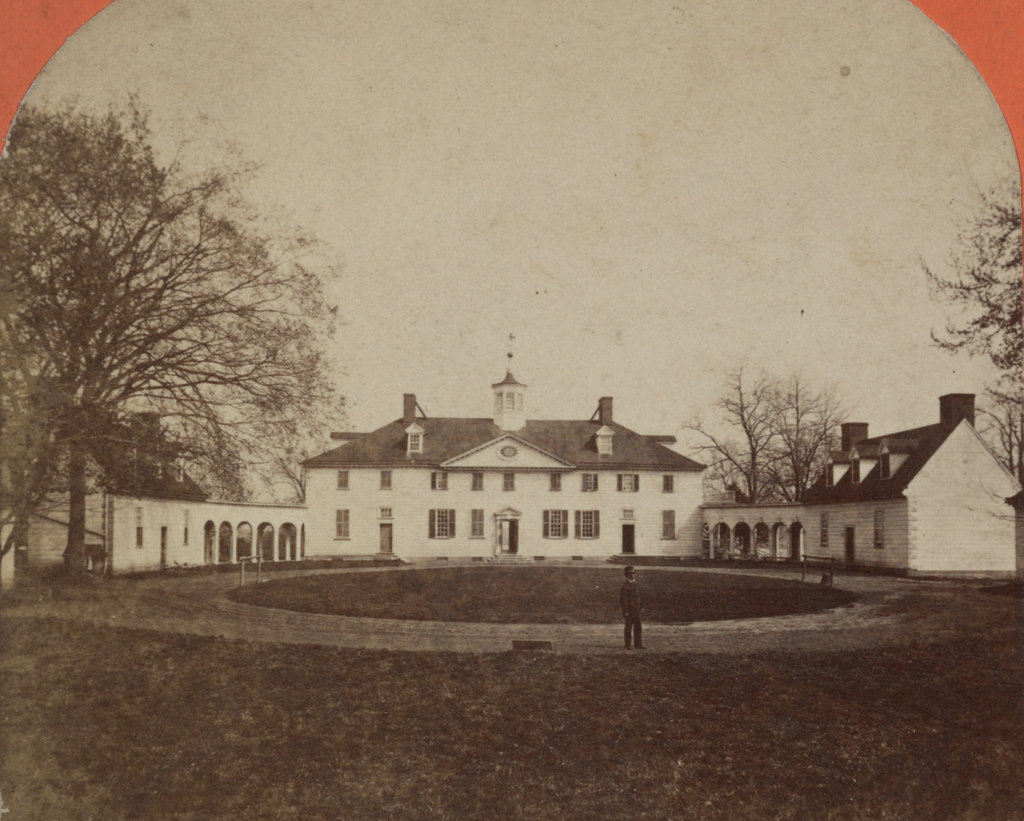
Another view of the Mount Vernon mansion, seen from the bowling green on the west side of the house, around the 1860s or 1870s. Image courtesy of the Library of Congress.

The mansion in 2018:

As discussed in the previous post, the Mount Vernon estate had been in the Washington family since 1674, when John Washington acquired the land. However, it was his grandson, Augustine Washington – the father of the future president – who constructed the original section of the mansion here on this site, in 1734. At the time, it was only one story, with a garret for the second floor, and it was comprised of what is now the four windows in the middle of the house.

George Washington’s older half brother, Lawrence Washington, later received the property from their father, and he lived here until his death in 1752. His widow, Anne, subsequently leased Mount Vernon to George Washington, starting in 1754. Four years later, he began the first expansion of the house, adding a full second floor with a garret above it. He gained ownership of the estate when Anne died in 1761, and in 1774 he embarked on an even more ambitious project, with two-story additions on both sides of the house.

The mid-1770s renovations also included two new outbuildings, which were connected to the house by colonnades, as shown in these photos. The building on the right was the kitchen, and it had three rooms on the first floor, along with a loft on the second floor. Like many kitchens of this period, it was separated from the main house as a fire safety measure. The building on the left was known as Servants Hall, and it had a design that matched that of the kitchen.. Although Washington did have slave quarters nearby, none of his slaves lived here. Instead, this building was used to house the servants – both black and white – of visitors to Mount Vernon.

George Washington lived here until his death in 1799, and Martha Washington died in 1802. They had no biological children together, so the estate went to his nephew, Bushrod Washington, who served for many years as a justice on the U. S. Supreme Court. The property was later inherited by Bushrod’s nephew, John Augustine Washington II, and then by John’s son, John Augustine Washington III.

Over the years, these later generations of the Washington family struggled to maintain the expensive estate, and in 1858 John Augustine Washington III sold it to the Mount Vernon Ladies’ Association. Under their ownership, the mansion was restored, and in 1860 it was opened to the public as one of the nation’s first historic tourist destinations. The first photo was probably taken within a decade or two after this, and it shows the house as it would have appeared to a Victorian-era visitor.

Today, some 150 years after this photo was taken, the Mount Vernon Ladies’ Association continues to operate the property as a museum. The mansion and the two outbuildings that are shown here have been well-maintained throughout this time, and there is hardly any difference between these two photos. Mount Vernon was designated as a National Historic Landmark in 1960, becoming one of the first places to be recognized as such, and it remains a popular tourist attraction, drawing around a million visitors each year.

Inauguration of Abraham Lincoln, Washington, DC

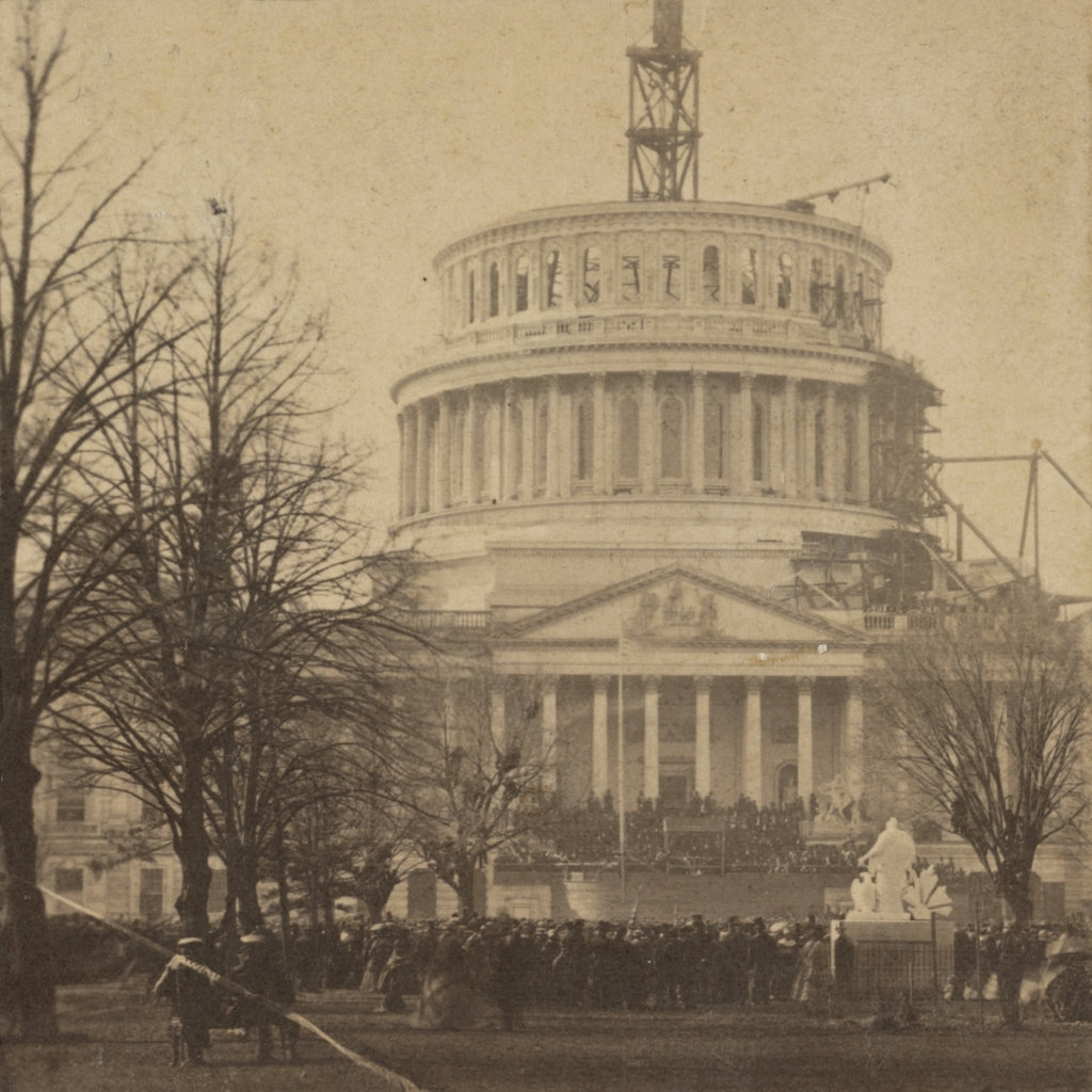
The east front of the United States Capitol, during the inauguration of Abraham Lincoln on March 4, 1861. Image courtesy of the Library of Congress.

The Capitol in 2018:

The first photo was taken around the same time as the one in a previous post, but this one shows the view from further back, with the entire unfinished Capitol dome in view, along with the crowd that had assembled for Lincoln’s first inauguration. It was the culmination of the highly-contentious 1860 presidential election, which saw the splintering of the Democratic Party into regional factions. Lincoln won the four-way race amid threats of secession from the south, and by the time he was inaugurated on March 4, 1861, seven southern states had followed through on their plans.

Because of this, there was a great deal of uncertainty on the day that the first photograph was taken. The start of the Civil War was just over a month away, and there were still plenty of questions about whether the South would be allowed to peacefully secede, or if the newly-inaugurated president would send an army to stop them. Appropriately enough, the backdrop to this event is the unfinished dome of the Capitol. Begun six years earlier, this new dome was still very much a work in progress during Lincoln’s inauguration, and it seemingly represented the as yet unfinished work of uniting the northern and southern regions of the nation.

The Capitol building itself is actually significantly older than this dome, though. Construction began in 1793, and the Senate and House wings were completed in 1800 and 1811, respectively. However, the building was burned in 1814, during the War of 1812, and its reconstruction was not ultimately finished until 1826. At the time, the building was topped by a low dome, which is visible in the first photo of another previous post. As the country grew, though, so did the Capitol building, and two new wings were added in the 1850s. As a result, the old dome looked out of proportion to the old building, so construction began on the current one in 1855.

During the early 19th century, the Capitol became the primary site of presidential inaugurations. At first, these ceremonies were held indoors, in either the Senate of House chambers, but in 1829 Andrew Jackson became the first president to be inaugurated here on the East Portico. This started a tradition that, with few exceptions, continued into the late 20th century. Jimmy Carter’s 1977 inauguration was the last to be held here on the East Portico, and since 1981 the ceremony has – with the exception of Ronald Reagan’s 1985 inauguration in the Rotunda – been held on the West Portico, on the side of the building facing the National Mall and the Washington Monument.

Four years to the day after the first photo was taken, Lincoln’s second inauguration would also be held here on the East Portico. By then, the exterior of the dome had been completed, and Lincoln’s goal of reuniting the nation had likewise been largely accomplished, with the end of the Civil War only weeks away. However, less than a week after Lee’s surrender, and only 42 days into his second term, Lincoln was assassinated by John Wilkes Booth, who had actually attended the second inauguration here, and had later claimed that he could have killed Lincoln during the event if he had wanted to.

Today, more than 150 years after the first photo was taken, the East Portico does not appear to have changed much. However, it actually underwent a major expansion starting in 1958, when a new portico was built 32 feet 6 inches in front of the old one. Aside from being built of marble, as opposed to the sandstone of the original walls, this new portico was essentially a duplicate. The old walls remain intact inside the building, although the original columns were removed and now stand in the National Arboretum. The 1958 renovations also involved the removal of two statues that once flanked the east steps. On the left, mostly hidden from view in the first photo, was Luigi Persico’s Discovery of America, and on the right was Horatio Greenough’s The Rescue. Both of these statues featured particularly unflattering depictions of Native Americans, and neither have been put on public display since then.

The other significant addition to this part of the Capitol occurred in the early 2000s, when the Capitol Visitor Center was constructed here. Consisting of 580,000 square feet of floor space on three floors, this massive expansion is almost entirely hidden from view in this scene, as it is located directly under the plaza in front of the East Portico. From this angle, the only visible signs of this underground complex are several skylights, including one on the far left side of the scene.

Ambrotype Saloon, Springfield, Mass

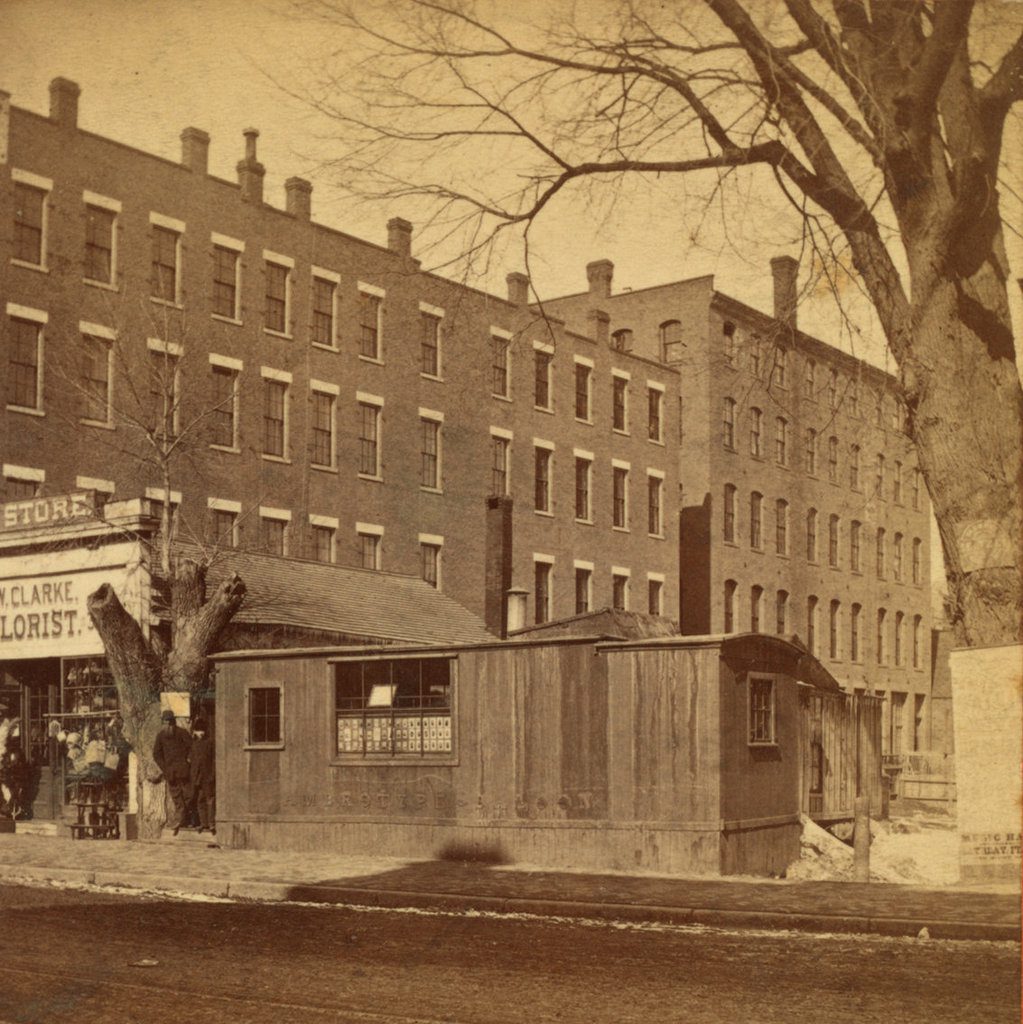
An ambrotype saloon on the east side of Main Street, between Bridge and Worthington Streets in Springfield, probably sometime in the 1870s. Image courtesy of the New York Public Library.

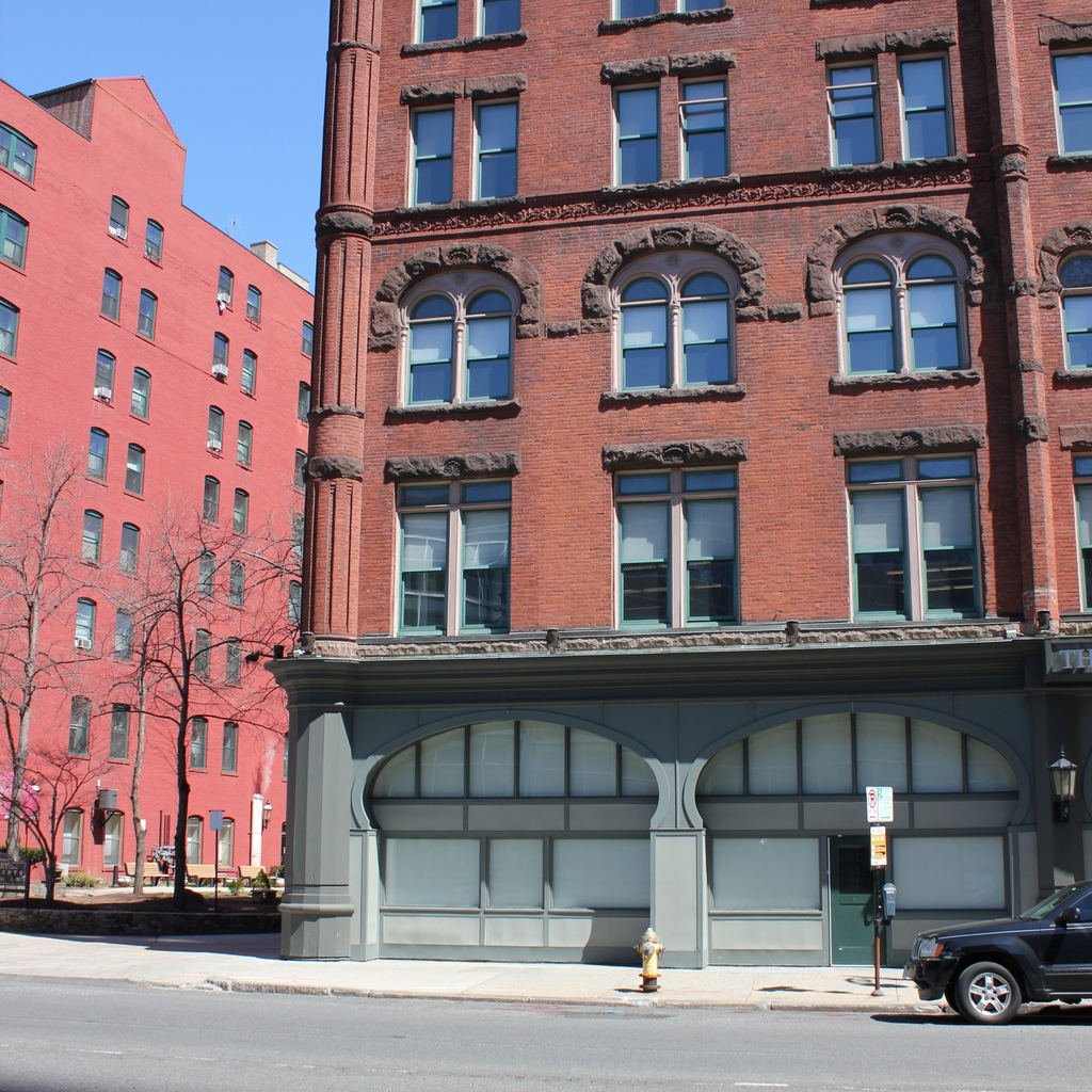
The scene in 2018:

The first photo depicts a small, trailer-like building that appears to have originally been a traveling photographic studio, as suggested by the words “Ambrotype Saloon,” which are barely visible on the side of the building. Common in the mid-19th century, during the early years of commercial photography, these horse-drawn studios – known as saloons – traveled across the countryside in search of business. They were often built by the photographers themselves, and they frequently served as both a workplace and living quarters for their nomadic owners.  A 1917 article in The Youth’s Companion, written by C. A. Stevens, provides the following description:

Those “saloons” were picturesque little structures, not much more than five feet wide by fifteen feet long; they were mounted on wheels. On each side was a little window, and overhead was a larger skylight; and a flight of three steps led up to a narrow door at the rear. The door opened into the “saloon” proper, where the camera and the visitor’s chair stood; forward of that was the cuddy under the skylight, in which the photographer did his developing.

During the heyday of these photographic saloons, the most popular types of images were daguerreotypes and ambrotypes. The daguerreotype was the first widespread form of photography, and it was common throughout the 1840s and 1850s before being superseded by the ambrotype, which was primarily used in the 1850s and early 1860s. With both of these techniques, each photograph was unique. Like Polaroid images a century later, the image was exposed directly onto the surface, so there were no negatives and no way to reproduce an image, aside from photographing it.

By the time the above photograph was taken in the 1870s, both the daguerreotype and ambrotype had long since been replaced by newer photographic processes. The traveling saloon was also becoming a thing of the past, and this particular one had evidently found a permanent home here on Main Street in Springfield. Its wheels were either gone or hidden behind wood paneling, and it appears to have been connected to a building in the rear of the lot.

According to the handwriting on the back, the building was, at the time, the studio of Warren S. Butler, a photographer who appears in city directories as early as 1872. This is likely the earliest possible date for the first photo, although the city directories do not provide a specific location for his studio until 1877, when he was listed here at this address. Despite the words on the side of the building, it is unlikely that Butler would have been producing ambrotypes here during the 1870s. Instead, his primary photographic medium would have been albumen prints such as cartes de visite and cabinet cards, both of which appear to be visible in the window. Unlike the earlier methods, these were made using negatives, which allowed photographers to produce multiple prints of the same image.

Aside from Butler’s appearance in city directories starting in 1872, there are several other clues that suggest the first photo was taken no earlier than the early 1870s. To the left of the studio is a florist shop that was run by Edmund W. Clarke, who, like Butler, does not appear in any directories until 1872. However, perhaps the most conclusive evidence is the presence of two large brick buildings in the background. Located on the southern side of Worthington Street, these buildings do not appear on the 1870 city map, and were likely constructed at some point in the 1870s.

Similarly, the latest possible date for the first photo is about 1886, the last time that Edmund W. Clarke’s florist shop appears at this address in the city directories. Butler is listed here as late as 1887, but both of these buildings were demolished by the end of that year, when this entire half of the block was cleared in order to build the Fuller Block. This five-story brick building was among the finest commercial blocks in the city when it was completed, and it still stands today, occupying a prominent location at the corner of Main and Bridge Streets.