East Court Street, Springfield Mass

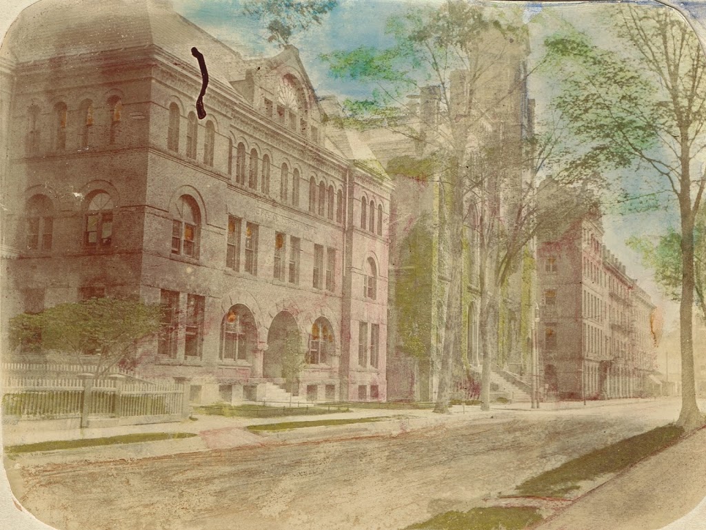
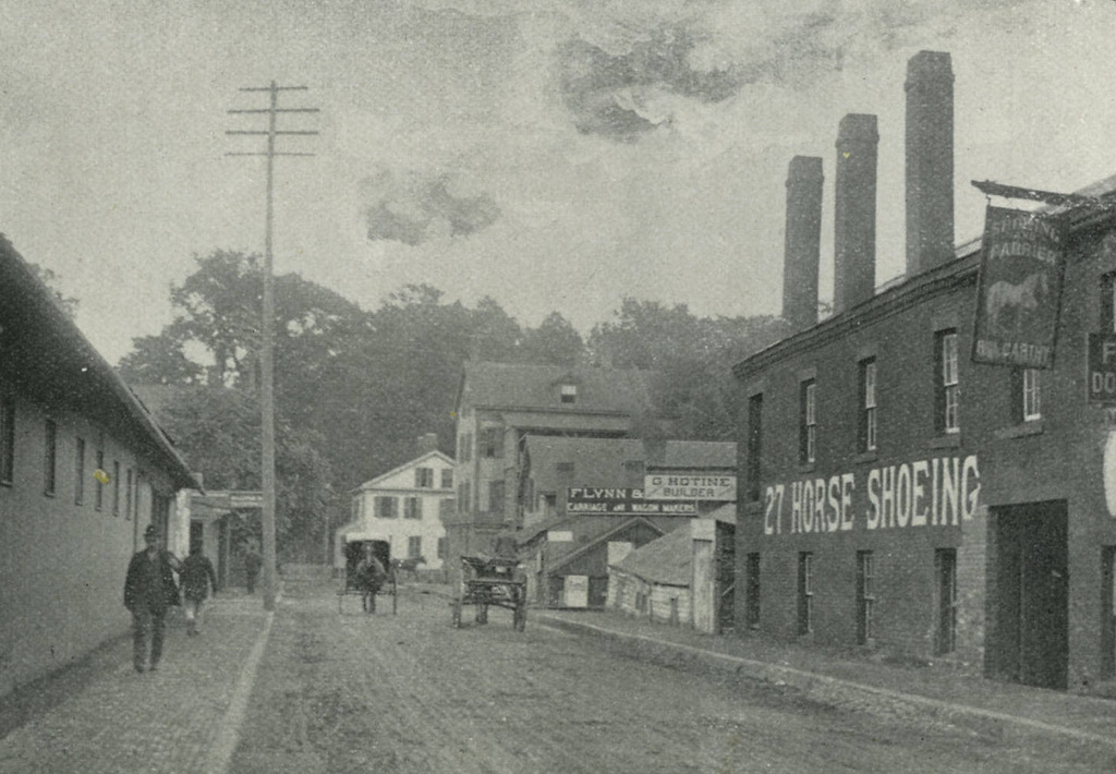
Looking east on East Court Street in Springfield, probably in the early 1890s. Photo from Picturesque Hampden (1892)

457_1892c picturesquehampden

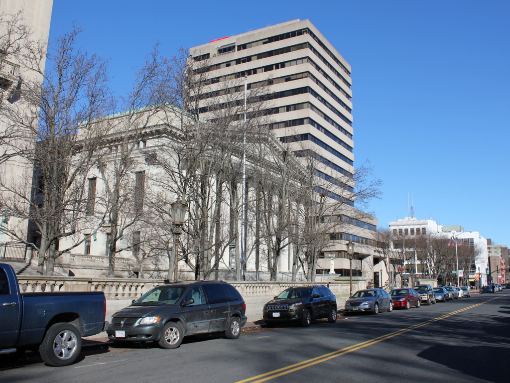
The street, now called Falcons Way, in 2015:

457_2015


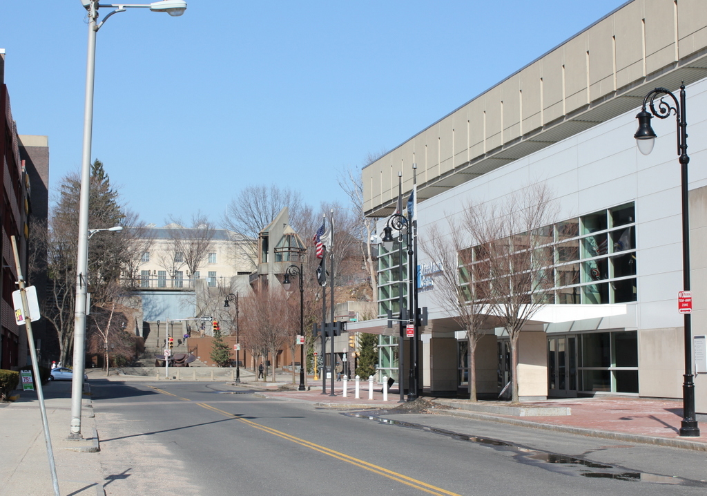
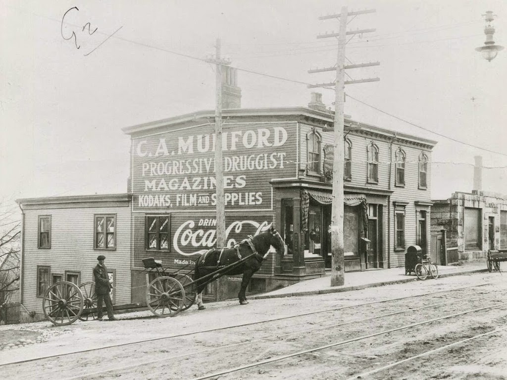
The land that the MassMutual Center now sits on was once the site of dozens of assorted buildings.  Along the busy and prominent Main and State Streets, one could find banks, publishers such as G & C Merriam (of Merriam-Webster Dictionary fame), and the elegant YMCA building.  However, along Dwight and East Court Streets sat less glamorous, more utilitarian buildings, including ancient colonial buildings being used as laundromats.  Here on East Court Street, most of the occupations themselves are as obsolete as the buildings that once housed them here – the signs reveal that one could procure services from wagon and carriage makers, horse shoers, and farriers (although I’m not sure what the distinction is between a horse shoer and a farrier).  Within just a couple decades, these industries would go the same way of blacksmiths and coopers, and by the 1970s all of the dozens of buildings in the four square block area would be demolished to make way for the MassMutual Center.

Court Street, Springfield, Mass

Court Street in Springfield, sometime before 1905. Photo from author’s collection.

444_1900c-2Bpersonalcollection

Court Street in 2014:

444_2014

I came across the first photo in a 3-for-$1 bin at an antique store, and despite the odd coloring it provides an interesting view along Court Street from around the turn of the last century.  It is an albumen print, mounted on thick paper, and evidently colorized after processing.  There are no identifying marks on the photo, and the only way I was able to figure out the location was because I recognized the old police station and City Hall as being in Springfield.  My guess is that it was probably taken sometime in the 1890s, but it could’ve been anytime before 1905, when the old City Hall burned down.

To the left of City Hall, in the foreground of the first photo, is the old police department headquarters, which was later demolished to make way for the Springfield Municipal Group.  The new City Hall, which was completed in 1913, is still there, on roughly the same spot that its predecessor stood in the first photo.  The site of the former police station is now the area between City Hall and Symphony Hall, where the campanile tower is.  In the background, One Financial Plaza building looms over City Hall, between City Hall Plaza and Main Street.  The only building in the present-day scene that would’ve even existed when the first photo was taken is the former Springfield Five Cents Savings Bank building at the corner of Main and Court Streets, although its Main Street facade has been altered beyond recognition.

Parsons Tavern, Springfield, Mass

Parsons Tavern on Court Street in Springfield, sometime in the late 1800s. Photo from Our County and Its People: A History of Hampden County, Massachusetts (1902).

Taverns

The scene in 2023:

When Springfield was settled by European colonists in 1636, it was at a strategic location along several different transportation routes.  As the years went by, the modes of transportation changed, but Springfield remained an important crossroads.  By the late 1700s, there were three major routes from New York to Boston, the northernmost of which went through Boston.  Although a less direct route than the other two, the Springfield route reportedly offered the best taverns, and in Springfield the best was Parsons Tavern.

The tavern was originally built on what is today the southeastern corner of Court Square, and was operated by Zenas Parsons.  During its time in operation, it hosted at least two presidents, the first of whom was George Washington in October, 1789.  Washington was on his way to Boston, and made a stop in Springfield to inspect the Armory.  He stayed overnight at Parsons Tavern, and wrote in his diary that “A Colo. Worthington, Colo. Williams (Adjutant General of the State of Massachusetts), Genl. Shepherd, Mr. Lyman and many other Gentleman sat an hour or two with me in the evening at Parson’s Tavern where I lodged and which is a good House.”  Years later, in 1817, President James Monroe also visited the tavern, not long before it was moved in order to make way for Court Square.

The tavern was relocated to Court Street around 1820, and it was eventually divided into a four-family apartment building. The top photo shows it in that location, probably sometime in the late 19th century. It stood here until 1897, when it was demolished. Today, the site of the building is a parking lot adjacent to the G.A.R. Hall, across East Columbus Avenue from Symphony Hall.

George Ashmun House, Springfield, Mass

The former home of Congressman George Ashmun, at 297 Union Street, Springfield Mass, around 1893. Photo from Sketches of the Old Inhabitants and Other Citizens of Old Springfield (1893)

382_1893c-2Bsketchesofoldinhabitants

The building around 1938-1939. Photo courtesy of the Springfield Preservation Trust.

382_1938-1939c-2Bspt

The location in 2015:

382_2015

The house in the first two photos is located at the corner of Union and School Streets, and was the home of lawyer and politician George Ashmun from 1838 to 1841.  Ashmun was first elected to the Massachusetts House of Representatives in 1833, at the age of 29.  He served there until 1837, then spent three years in the Massachusetts Senate before returning to the House and serving as Speaker in 1841.  He later represented the Sixth District of Massachusetts in Congress from 1845 to 1851.

However, his most significant political and historical moment came in 1860, when he served as the chairman of the Republican National Convention in Chicago.  Going into the convention, Senator William Seward had been the favorite to win the nomination, but in the end, the delegates chose Abraham Lincoln, a former colleague of Ashmun who served alongside him in the House.  As the chairman, he traveled to Springfield, Illinois, to inform Lincoln that he had received the nomination.

Ashmun worked with Lincoln throughout his presidency, meeting with him for the last time in the White House on the evening of April 14, 1865, shortly before Lincoln left to attend a play at Ford’s Theatre.  When they departed, President Lincoln promised to meet with him the next morning; this meeting obviously did not happen.

The house that Ashmun once lived in still stood at the corner of Union and School until around the mid 20th century; it was there when the WPA photo was taken in the late 1930s, but was probably demolished when the present-day school building was built in 1962.

Barrington Street, Halifax, Nova Scotia (2)

Another scene on Campbell Road (today’s Barrington Street) in Halifax, Nova Scotia, before the 1917 Halifax Explosion. Photo courtesy of the Nova Scotia Archives.

Canada

The scene in 2014:

353_2014

The first photo is undated, but the absolute earliest date would be 1888, although it is probably a little later than that, perhaps around 1900.  A few clues give it away, with one being fairly obvious: the Coca Cola advertisement on the side of the building.  Coca Cola was established in 1886, but it is unlikely that it would have made its way to Canada so quickly.  Perhaps less obvious of a clue is the bicycle leaning against the mailbox; this now-ubiquitous style of bicycle, known as the “safety bicycle” – because it was safer than a penny farthing – was not developed until the late 1880s.  Finally, the reference to “Kodaks” in the drugstore sign indicates that it must be 1888 or later, and probably later.  Kodak was founded in 1888, but the sign seems to indicate that people were already familiar with it by then, which suggests a somewhat later date.

These photos were taken from almost the same spot as the ones in this post, just from a slightly different angle, at the corner of Barrington and Young Streets.  As mentioned in the other post, this entire area would be leveled by the 1917 Halifax Explosion, and today the scene looks entirely different.  In the distance is the Angus L. MacDonald Bridge, one of two that cross the Narrows of Halifax Harbour, the same area where the explosion occurred.

Barrington Street, Halifax, Nova Scotia (1)

The view looking south on Campbell Road (today Barrington Street) sometime before the 1917 Halifax Explosion. Photo courtesy of the Nova Scotia Archives.

352_1860-1917-2Bnsarchives

The scene in 2014:

352_2014

It’s not in New England, but Halifax has historically had close ties with New England, particularly in the aftermath of the Halifax Explosion, when an ammunition ship exploded in the harbor on December 6, 1917, leveling much of the city and killing several thousand people.  This section of road was right near ground zero, and the buildings in the first photo, if they were still standing before the explosion, were certainly not standing afterward.  The first photo was probably taken around 1900, in what was at the time a mix of residential and commercial uses.  Today, the waterfront (left) side of the road is primarily industrial, with some commercial development to the right.  Overall, the c.1900 scene is entirely unrecognizable today.