Beacon Street from Arlington Street, Boston

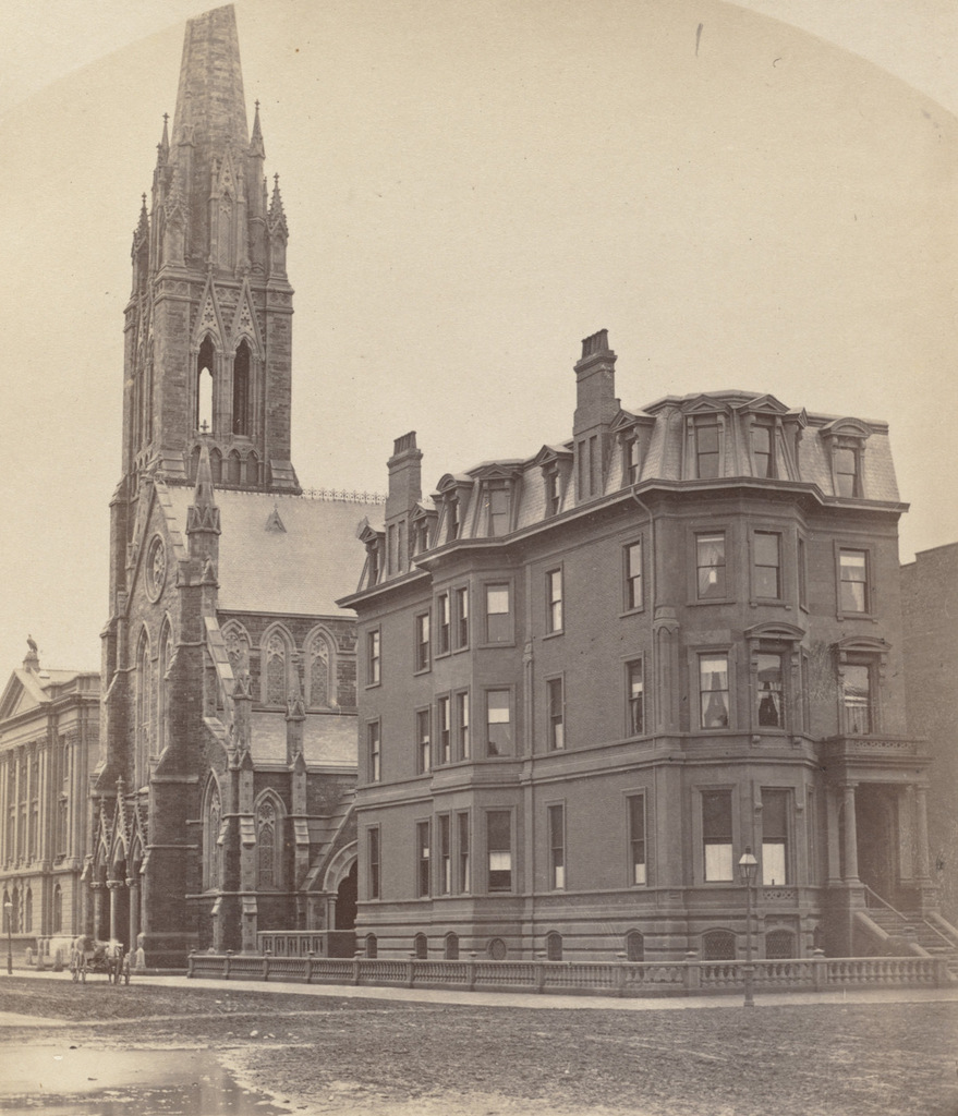
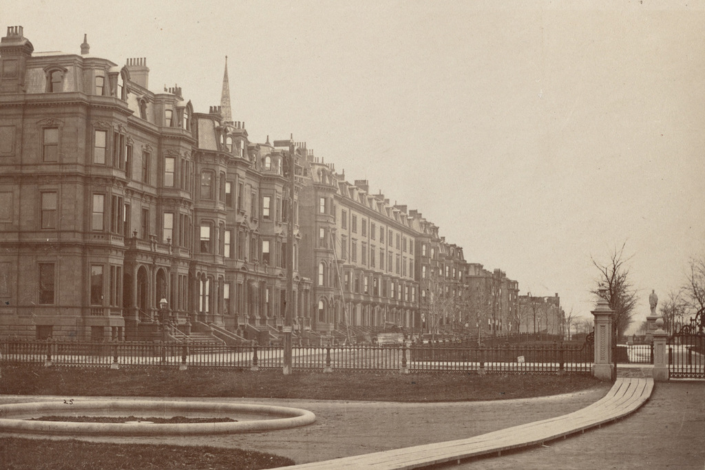
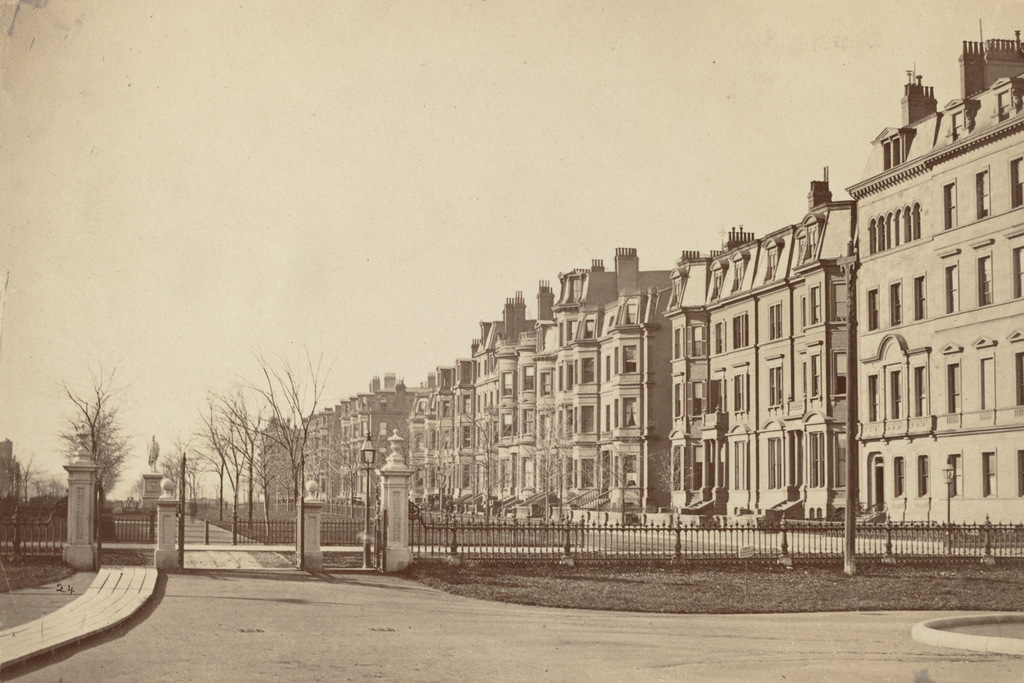
Looking west on Beacon Street from the corner of Arlington Street, in 1870. Image courtesy of the Boston Public Library.

812_1870 bpl

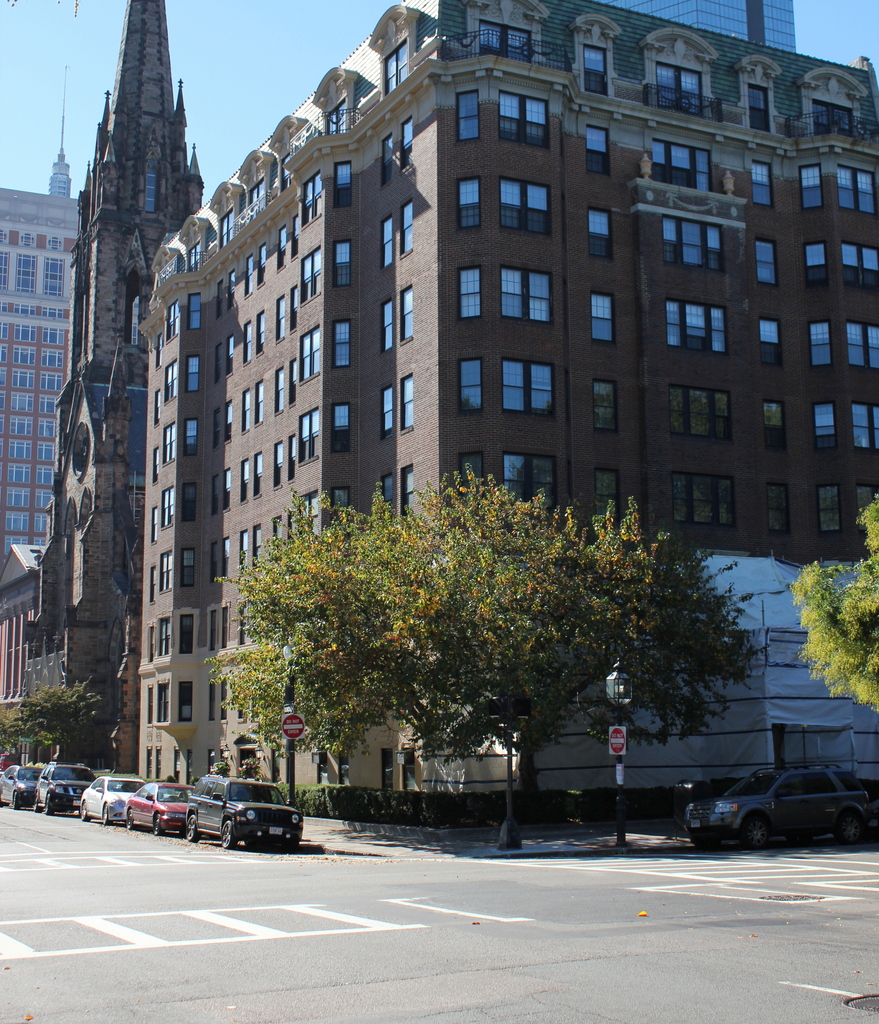
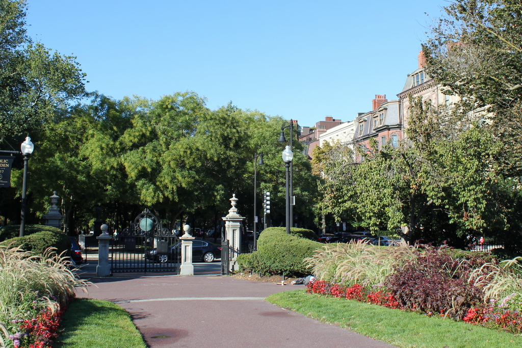
Beacon Street in 2015:

812_2015

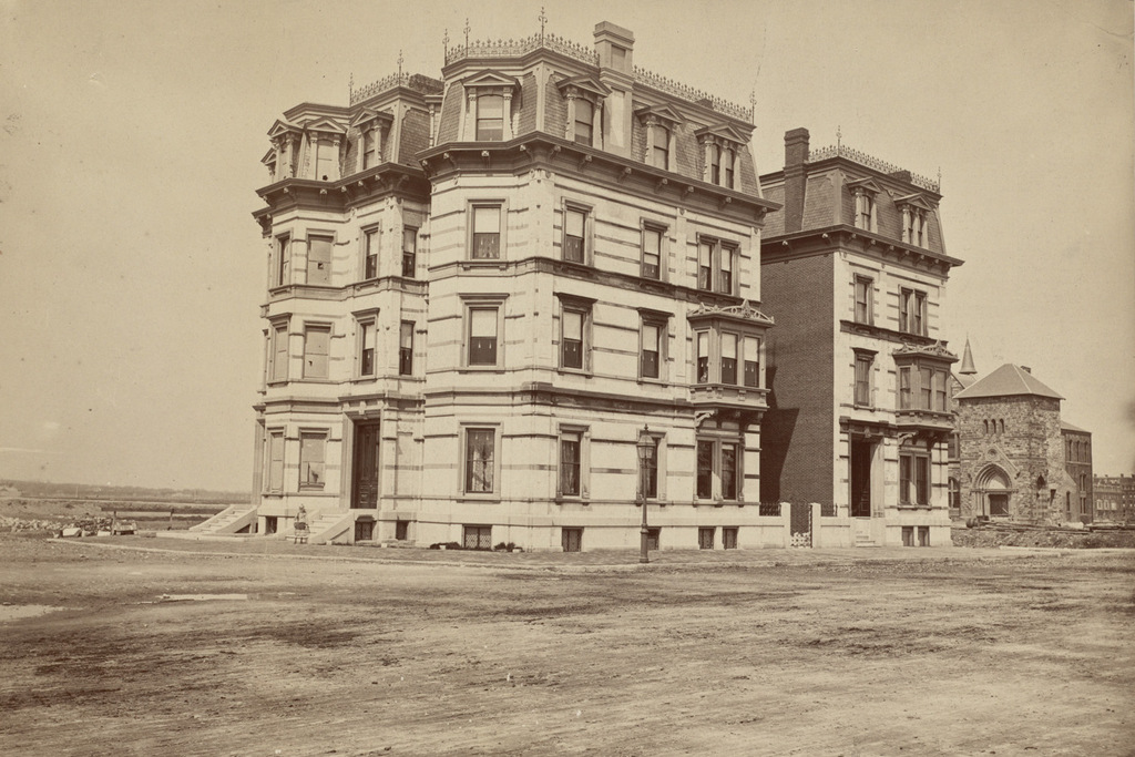
The houses on the right side of this scene are the oldest buildings in the Back Bay, dating back even before the large-scale landfill project had begun. The origins of Beacon Street date back to 1818, when construction began on a dam across the Back Bay, which at the time was a tidal marsh connected to the Charles River. The dam used the power of the tides to operate factories nearby, but it also had an added benefit of serving as a second route in and out of Boston, by extending Beacon Street across it.

The dam, which was completed in 1821, turned out to be a failure, and by the 1850s there were plans in the works to fill the Back Bay and expand Boston’s land area. The houses here on the right side of the street were built around 1856 on land that had already been filled; they can be seen in the distance in the first photo in this post, which was taken from the top of the State House in 1857. By the time the 1870 photo above was taken just 13 years later, the landfill project was well underway, and both sides of Beacon Street had been developed as far as Dartmouth Street, three blocks in the distance.

Nearly 150 years after the first photo was taken, many of the buildings from the first photo are still standing, including most of the 1850s houses to the right. The only major change in the foreground is the pair of houses on the far right, numbered 100-102 Beacon Street. Half of the building was demolished in 1924 to build the apartment building that stands there today. The other half at 102 Beacon is still standing, although it was altered beyond recognition in 1938, when it was converted into an 18-unit apartment building with a new facade. However, the next seven houses in a row, numbered 104-116 Beacon Street, also date back to around 1856. They are all virtually identical, and 160 years later all seven are still standing, essentially unchanged on the exterior. The use of the buildings has changed, though; today, all seven, along with the neighboring properties at 102 and 118 Beacon Street, are owned by Fisher College and are used for classrooms and dormitories.

For more information on the history of these houses, see the Back Bay Houses website.

50 Commonwealth Avenue, Boston

The house at the southwest corner of Commonwealth Avenue and Berkeley Street in Boston, sometime in the 1870s. Image courtesy of the Boston Public Library.

810_1870-1879c bpl

The scene in 2015:

810_2015
The house in the first photo was built around 1868, and for many years it was the home of dry goods merchant John Hogg. He and his wife Emma lived her from when it was built until around 1892, and the subsequent owners, Frank and Mary Going, operated it as a hotel called The Holland. Like many other hotels of the era, it functioned more as a boarding house than as a place for transient visitors, and it continued in this capacity until 1925, when it and the neighboring 52 Commonwealth were demolished. They were replaced with the current building,which has 40 apartments that were converted into condominiums in 1985.

Although the house from the first photo is no longer standing, the other two buildings beyond it have survived. The church is the Central Congregational Church, which was built in 1867 and is now the Church of the Covenant. Beyond the church is the distinctive facade of the former Museum of Natural History building at the corner of Berkeley and Newbury Streets. Built in 1863, it is among the oldest public buildings in the Back Bay, and after many years as the home of Bonwit Teller, it is now a Restoration Hardware gallery.

For more information on the history of the house at 50 Commonwealth Ave, please see this post on the Back Bay Houses website.

29-33 Commonwealth Avenue, Boston

The houses at 29-33 Commonwealth Avenue, just west of Berkeley Street, sometime in the 1870s. Image courtesy of the Boston Public Library.

809_1870-1879c bpl

The view in 2015:

809_2015
These three townhouses at the northwestern corner of Commonwealth Avenue and Berkeley Street were built around 1863, on land that had been recently filled in the Back Bay. The neighborhood was designed from the start as a wealthy, exclusive area; Boston had feared that its upper class would flee the crowded city for the suburbs, so the Back Bay project was intended to encourage rich Bostonians to remain in the city.

When the first photo was taken, all three of these homes were owned by wealthy families. To the left, 33 Commonwealth Avenue was the home of Charles H. Dalton, a merchant and businessman who served as the president of several different businesses. He also served as the treasurer of MIT, which was just a couple blocks away at the time, and as president of Massachusetts General Hospital. The house in the middle was owned by another businessman, Joseph Sawyer, who owned textile factories. Both men died shortly after the turn of the 20th century, and eventually the two buildings were converted into apartments. It is hard to see both in the 2015 photo, but they are still standing today, and have since been combined to create a 7-unit condominium building.

Unlike its neighbors to the left, the house at 29 Commonwealth Avenue did not even survive to the end of the 19th century. It was originally the home of textile mill owner Joshua Stetson, and after his death the house was sold to Elizabeth Bowditch in 1870. She was the widow of Nathaniel Ingersoll Bowditch, a lawyer who was the son of noted mathematician Nathaniel Bowditch, and she lived here until her death in 1892. The house was then sold and demolished, and replaced with a 9 story, 26 unit apartment building in 1894. It was completed before there were any height restrictions in the Back Bay, so it is substantially taller than most other 19th century buildings in the area. In the 1920s, its apartments were converted into offices, and it has remained an office building ever since.

The church to the right just behind 29 Commonwealth Avenue is the First Church of Boston. It was built in 1867 at the corner of Marlborough Street, and it was mostly destroyed in a fire in 1968. The steeple and parts of the facade were saved, though, and they were incorporated into the design of the current building.

For more information, visit the Back Bay Houses website, which has more details and photographs of 29 and 31-33 Commonwealth Avenue and the First Church in Boston.

Dartmouth Street and Huntington Avenue, Boston

The northwest corner of Dartmouth Street and Huntington Avenue in Boston, in 1873. Image courtesy of the Boston Public Library.

807_1873 bpl

The scene in 2015:

807_2015
Today, Copley Square is a major focal point of the Back Bay neighborhood, but in 1873 it was still very much a work in progress. Although the Boston Public Library’s McKim Building would come to be a defining feature of the square, its completion was still more than 20 years away. The house in the first photo was the western extent of the Back Bay development at the time; beyond it in the distance are empty lots and marshland soon to be filled in for the project. Aside from this house, the only other building visible in the scene is the New Old South Church, which was under construction to the right.

The church is still standing today, but the house would not last very long here. By the late 1880s, it was demolished to build the main branch of Boston Public Library. This architecturally prominent building would serve as a predecessor to many other grand urban libraries in the country, and today it is as much a museum as it is a library, with significant collections of rare books, manuscripts, artwork, and photographs, including the 1873 photo featured here.

Commonwealth Avenue, Boston (2)

The view along the south side of Commonwealth Avenue, looking west from the Boston Public Garden, sometime in the 1870s. Image courtesy of the Boston Public Library.

805_1870-1879c bpl

The view in 2015:

805_2015
These photos were taken from the same spot as the ones in the previous post, probably even on the same day. As with the other post, the 2015 view here is mostly obscured by the trees on the Commonwealth Avenue Mall, but beyond the trees many of the historic Victorian brownstones are still standing. Because the Back Bay project began here at Arlington Street and worked its way west, the houses at this end of Commonwealth Avenue are among the oldest in the neighborhood, dating mostly to the early to mid 1860s. The houses in the foreground have since been replaced with a high-rise building, but otherwise almost all of the ones between here and Berkeley Street are still standing, and today they make up part of the Back Bay Historic District on the National Register of Historic Places.

Commonwealth Avenue, Boston (1)

Looking west along the north side of Commonwealth Avenue from the Boston Public Garden, sometime in the 1870s. Image courtesy of the Boston Public Library.

804_1870-1879c bpl

The scene in 2015:

804_2015
From the start, the Back Bay was designed to be an upscale residential neighborhood, and these houses on the north side of Commonwealth Avenue typically commanded the highest prices. Here, the residents enjoyed the view of the broad Commonwealth Avenue Mall, and their southern-facing front windows gave them plenty of light. The work of filling the land and building homes began here at Arlington Street in the early 1860s, and as the years went on the development moved westward. By the early 1870s, Commonwealth Avenue reached as far as Exeter Street, four blocks from here. Most of the houses in the foreground of the first photo were built in the early to mid 1860s, when the block between Arlington and Berkeley Streets was developed. They represent the typical residential design for the Back Bay, with 3 to 4 story Victorian brownstones lining the streets that had to conform to strict building codes at the time.

Nearly 150 years after the first photo was taken, the strict building codes have paid off. The neighborhood retains its original 19th century residential appearance, and many of the houses from the first photo are still standing today. The trees, which were just saplings in the 1870s, now hide the view of most of the houses from here, but a few of the buildings are visible to the right, and are easily recognizable from the first photo.There have been some newer houses, like the light-colored one just to the right of the lamppost, but these have generally been in keeping with the original appearance of the neighborhood.