Milk Street, Boston (2)

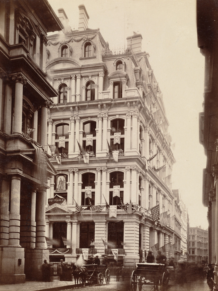
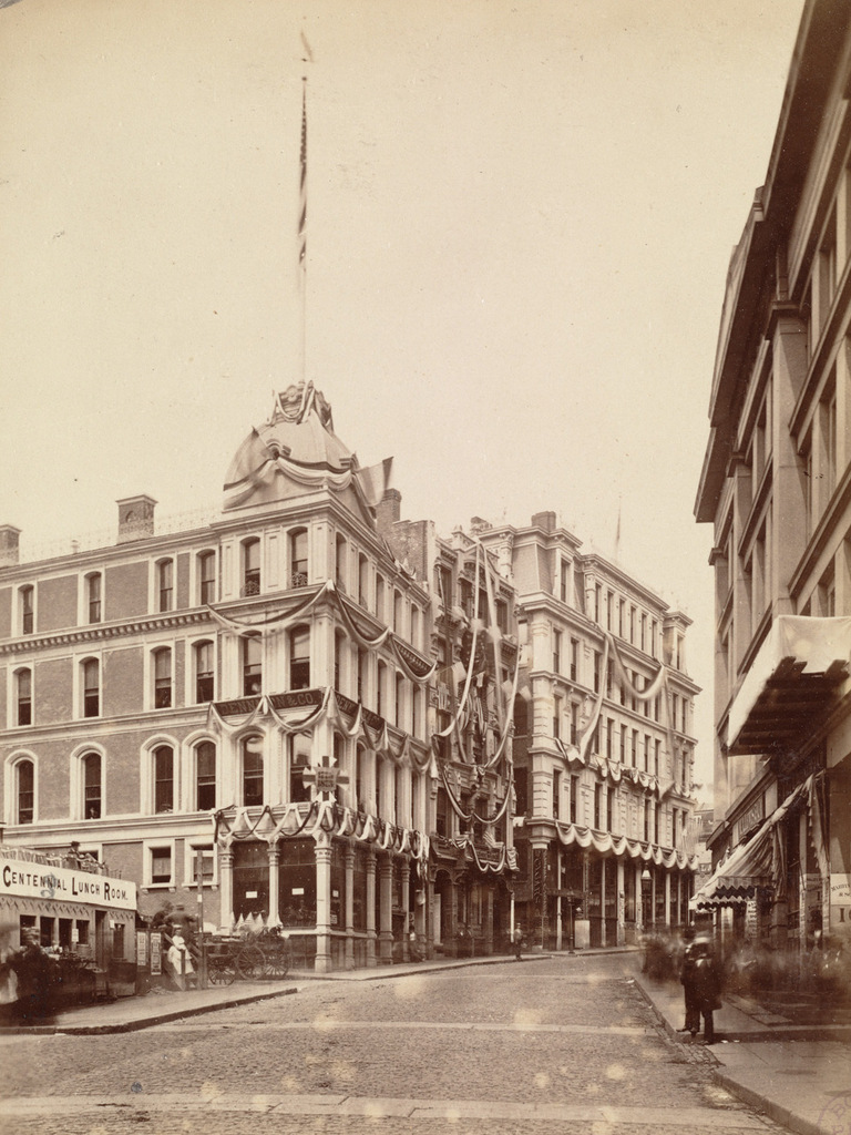
Looking west up Milk Street from Devonshire Street in Boston, on June 17, 1875. Image courtesy of the Boston Public Library.

819_1875-06-17 bpl

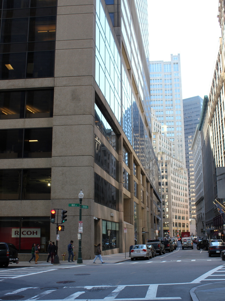
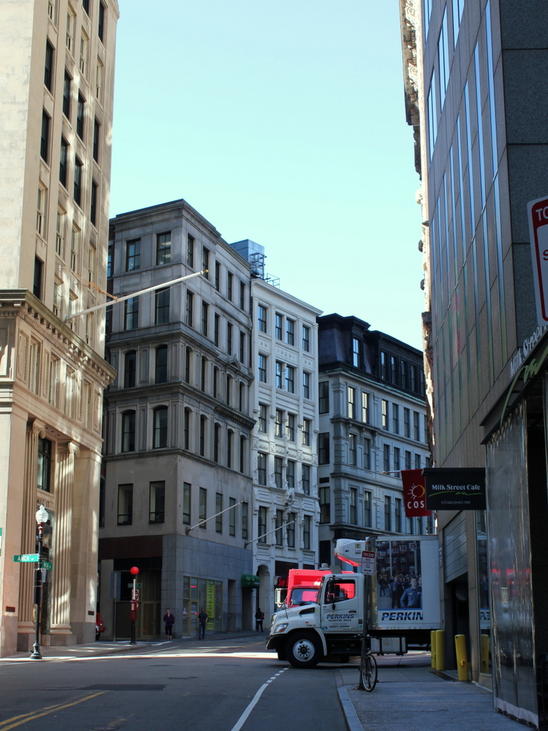
Milk Street in 2015:

819_2015
When the first photo was taken, the city was celebrating the 100th anniversary of the Battle of Bunker Hill, and these buildings on Milk Street were covered in patriotic bunting. All three of the buildings in the center of the photo were new; just three years earlier the area had been destroyed in the Great Boston Fire of 1872, as seen in the view looking down Milk Street in this post. However, the city soon rebuilt, and this area quickly became a major commercial center again.

All three of these buildings survive today, although with some alterations. The one on the left, at the corner of Milk and Hawkey Streets, is the Goddard Building. It was completed in 1873, and over the years it has been expanded, with two additional stories on top. The building to the right of it has also grown over the years. It was built on the site of Benjamin Franklin’s birthplace, and the decorative facade includes a bust of Franklin above the second story windows. The third building in the photo, on the right, was also built in 1873, at the corner of Milk and Washington Streets. It was originally the home of the Boston Transcript newspaper, which at the time was the largest circulating daily newspaper in New England. The newspaper has been defunct since 1941, but the historic building is still standing today.

Franklin Street, Boston (3)

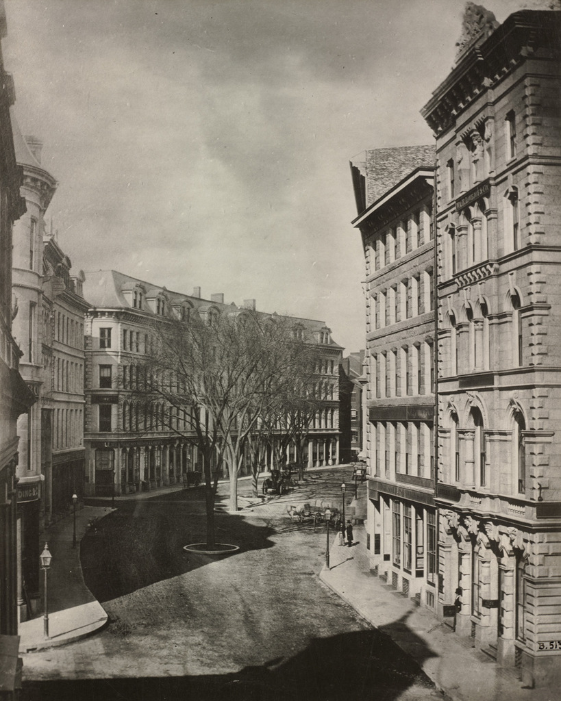
Looking west on Franklin Street from Devonshire Street in Boston, sometime in the late 1850s. Image courtesy of the Boston Public Library.

818_1857c bpl

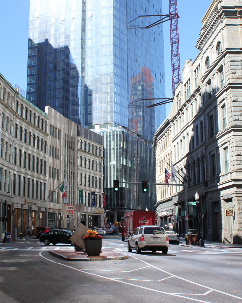
Franklin Street in 2015:

818_2015
This view of Franklin Street shows the former Tontine Crescent section of the street from the opposite direction of the photos in these posts here and here. When this area was developed by architect Charles Bulfinch in the 1790s, it was an upscale residential neighborhood. Just a few years before the first photo was taken, this curve was lined with elegant townhouses, but by the late 1850s nothing remained of Bulfinch’s design except for a few trees in the middle of the street and the curve of the street itself.

The new commercial buildings in the first photo represented Boston’s growth and development as a prominent city, but they would turn out to be short-lived. Just over a decade later, the entire area was destroyed in the Great Boston Fire of 1872. They were rebuilt within the next year or so with similar-looking buildings, and many are still standing today. The 2015 photo shows a number of these 1870s buildings, although the background is dominated by Boston’s newest skyscraper, the Millennium Tower, which was under construction in the first photo and is scheduled to be completed in the summer of 2016.

Boylston Market, Boston

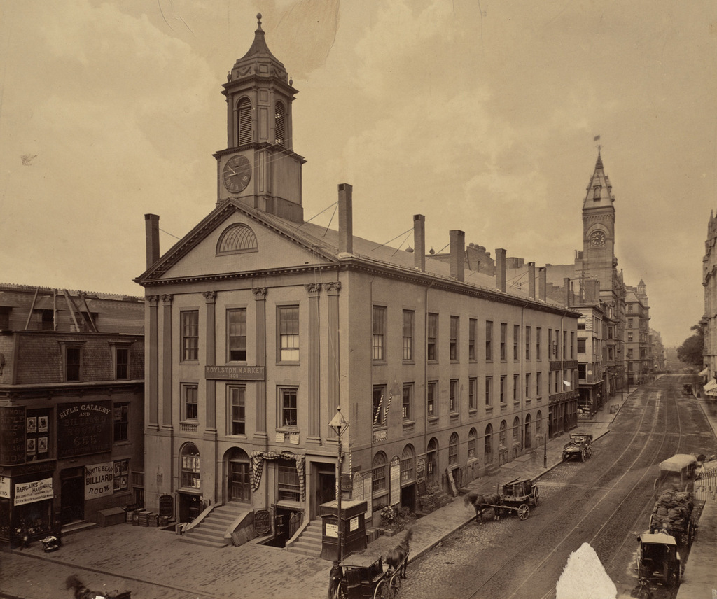
Boylston Market, at the corner of Boylston and Washington Streets in Boston, around 1870. Image courtesy of the Boston Public Library.

816_1870c bpl

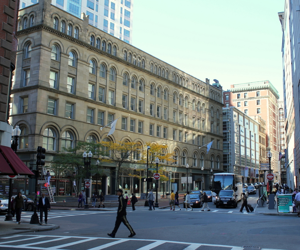
The scene in 2015:

816_2015
Boylston Market was built here in 1810, and it was designed by noted architect Charles Bulfinch. It functioned as a market on the first floor, and a meeting space and performance hall on the third floor, known as Boylston Hall. Both the building and the street were named for Ward Nicholas Boylston, a Boston philanthropist who gave substantial donations to Harvard in the early 19th century. Prior to its construction, the city’s primary marketplace was Faneuil Hall, which was a considerable distance away from here. At the time, this area was in the southern end of the city, and some of its residents, including future president John Quincy Adams, formed the Boylston Market Association to built the market here

Aside from its use as a marketplace, the building was also used by organizations such as the Handel and Hadyn Society, which held concerts in the third floor hall, and the New England Anti-Slavery Society, which held conventions in the same hall. In 1859, it was expanded, and in 1870 it was moved 11 feet south away from Boylston Street. This is presumably why the building to the left in the first photo, home of the White Bear Billiard Room, has a sign that reads “Building to be Torn Down.”

Although moving the large brick building was a significant undertaking, Boylston Market was demolished just 17 years later, in 1887. It was replaced by the Boylston Building, which served much the same function as its predecessor, with retail space on the first floor and warehouse and office space on the upper floors. As seen in the 2015 photo, it is still standing today, and it is listed on the National Register of Historic Places. There is at least one surviving element from the original building, though. The cupola was saved, and it now forms the steeple of the Calvary Methodist Church in the nearby town of Arlington.

Main Street, Lee, Mass

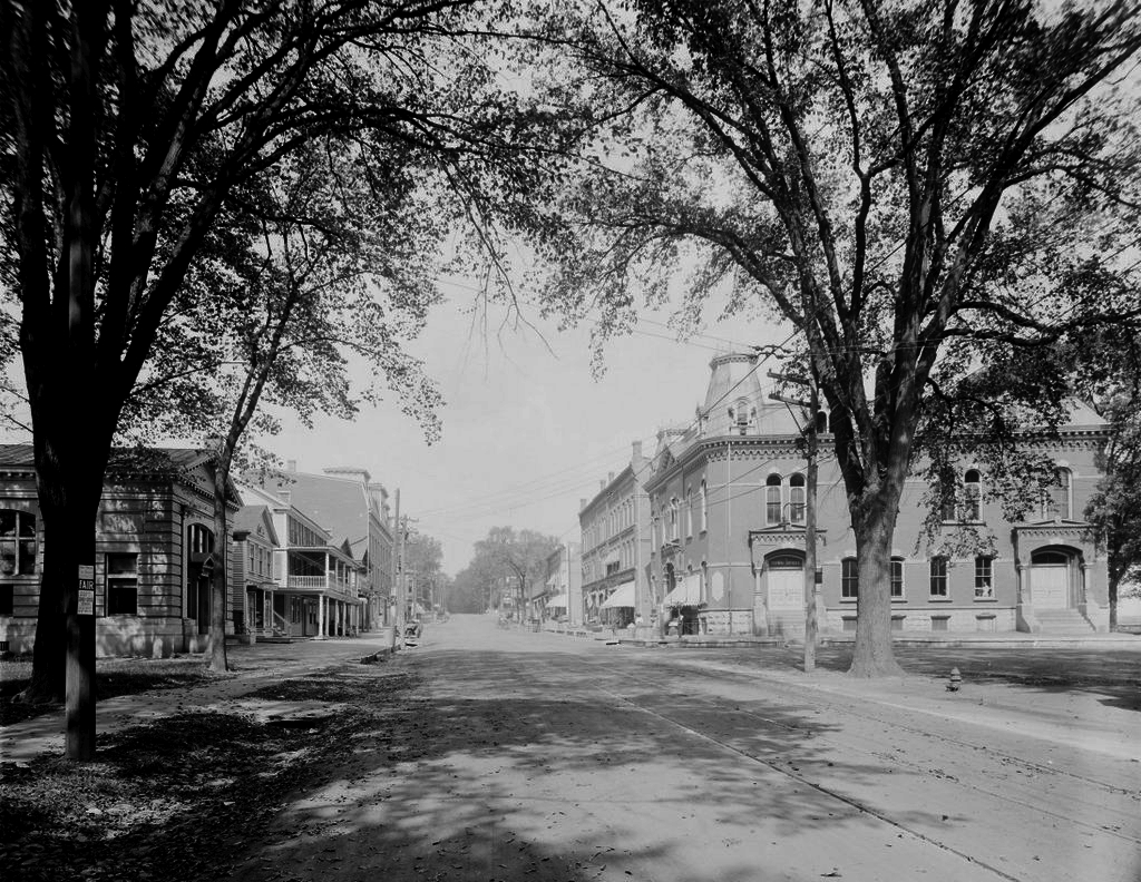
Looking north on Main Street from near Park Street in Lee, in 1911. Image courtesy of the Library of Congress, Detroit Publishing Company Collection.


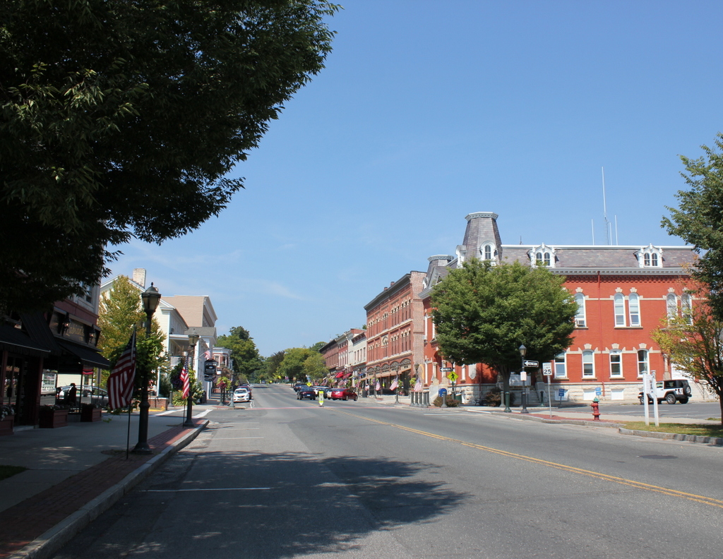
Main Street in 2015:

785_2015
The town of Lee is situated in the Berkshires region of Western Massachusetts, and in the 19th century it was a small but prominent industrial town. At its peak, the town had several dozen paper mills and several marble quarries, and the town’s prosperity was reflected in its downtown area here along Main Street. Most of the buildings in this scene date to the mid to late 19th century, including the historic Memorial Town Hall to the right. It was completed in 1874, and has housed the town offices ever since. Through the years, it has also taken on a variety of other uses, including a post office, Grand Army of the Republic hall, barber shop, movie theater, district court, and police station. In 1965, singer Arlo Guthrie faced littering charges in the courtroom here, an incident which later inspired his famous song “Alice’s Restaurant.” Today, in addition to the town offices, it is also the town police station, and although it has undergone renovations in 1912 and in 1990-1991, its exterior has remained well preserved for over 140 years.

Just beyond the Memorial Town Hall is the Baird and Benton Block, a three story commercial building that was built in 1875 by paper manufacturers Prentiss Baird and Charles and James Benton. It originally had a mansard roof like the neighboring Town Hall, but the roof was destroyed in a fire in the late 1800s. Aside from renovations to the first floor storefronts, the building’s appearance is similar to what it looked like in 1911, but the upper two floors were vacant from the 1950s until a renovation in 2012 that converted it into classroom and office space.

Most of the other commercial building in the scene date from the second half of the 19th century, but the oldest is the Morgan House, the wood-frame building with the two story porch on the left side of Main Street. It was built in 1817 by William Porter as a house, and in 1867 it was purchased by Edward Morgan, who enlarged the original building and turned it into the Morgan House inn. Over the years, its guests have included Ulysses S. Grant, Grover Cleveland, John F. Kennedy, and George Bernard Shaw, and today it is still operated as an inn and restaurant.

Overall, the only significant change to this scene is the Park Building, located on the far left where the Lee Savings Bank building stood in the 1911 photo. It was built just a few years later in 1914, and it is one of the newest buildings along this section of Main Street. The entire area is now part of the Lower Main Street Historic District on the National Register of Historic Places, and it is an excellent surviving example of a historic 19th century New England town center.

Washington Street, Boston

Looking north on Washington Street from School Street in Boston, around 1906. Image courtesy of the Library of Congress, Detroit Publishing Company Collection.

779_1906c loc

Washington Street in 2015:

779_2015
In the days before radio, television, and internet, the only major news source for most people was newspapers.  At the turn of the 20th century, large cities had many newspapers, which were often published twice daily.  However, for timelier updates, newspapers often posted breaking news, election results, and sports scores on bulletin boards outside of their offices.  In some cities, such as New York and here in Boston, many newspapers had offices in the same area, known as Newspaper Row.

Boston’s Newspaper Row was located along Washington Street, between Milk and State Streets, and at one point included up to 17 newspapers, including several in this scene.  On the far left of the first photo, partially blocked by the trolley car, is the Boston Post, and further down the street, the tall building to the left had been the home of the Boston Herald.  As the advertisement on the building indicates, the Herald had recently moved to a new location on Tremont Street.  Both the Post and the Herald buildings have since been demolished, and a parking garage now stands there.  The Post, which was established in 1831, was a major daily newspaper in New England until it closed in 1956.  The Herald, however, is still around today, 170 years after it was first published in 1846.

The large building in the distance in the left-center of the first photo was the home of the Boston Globe, the narrow building next to it was the Boston Advertiser, and the tall building in the center of the photo was the Boston Journal.  Of these three, the Globe was by far the newest of these newspapers, having been established in 1872.  The Advertiser, on the other hand, had been published since 1813 as the first daily newspaper in the city, and the Journal since 1833. However, the Globe ended up outliving both of them, as the Journal merged with the Herald in 1917, and the Advertiser was purchased by William Randolph Hearst the same year and was discontinued in 1929.  Both the Globe and the Advertiser buildings here have since been demolished, but the Journal building still stands as the only survivor of the five turn-of-the-century newspaper buildings in this scene.  The building opened in 1901, and was the home of the Journal until its merger with the Herald.  Since then, it has been used for other professional offices.

There are no longer any newspaper offices along this section of Washington Street; the Globe left in 1958, and it has been many years since Newspaper Row was the center of news information in the city.  It is also much less crowded; the first photo shows the narrow street filled with pedestrians, carriages, and trolleys, but within a few years the Washington Street Tunnel would be completed.  This subway tunnel eliminated some of the congestion by taking the trolleys off of the streets, and it formed the precursor to today’s Orange Line, which still runs under this section of Washington Street.

Despite the changes over the years, there have been several constants.  The Old Corner Bookstore, which is just out of view in the first photo but visible on the far left in the second one, is the oldest of them all.  It was built in 1712, and it is still standing as one of the oldest buildings in downtown Boston, and just beyond it is the Andrew Cunningham House, which was built a few years later around 1725.  Aside from these two colonial-era buildings, though, there are several other historic buildings in the scene.  On the far right is the Old South Building, a large office building that was completed shortly before the first photo was taken.  It wraps around the Old South Church between Washington and Milk Streets, and its Milk Street facade can be seen in this post.  The other prominent historic building here is the Winthrop Building, located just beyond the Old South Building at the corner of Washington and Water Streets.  A view of the long side of this building can be seen in the “now” photo of this post, which shows it from the Water Street side.  It was built in 1893 on a long, narrow, irregularly-shaped lot, and it was Boston’s first steel frame skyscraper.  It is still standing today, and is now on the National Register of Historic Places.

Chickering Hall, Boston

Chickering Hall on Huntington Avenue near Massachusetts Avenue in Boston, around 1901-1906. Image courtesy of the Library of Congress, Detroit Publishing Company Collection.

771_1900-1906 loc

The site in 2015:

771_2015
This section of Huntington Avenue is also known as “Avenue of the Arts,” and it is home to a number of theaters, as well as Northeastern University, the Massachusetts College of Art and Design, and the Museum of Fine Arts.  One of the early concert halls here was Chickering Hall, which was built in 1901 by Chickering & Sons, a Boston piano manufacturer.  The name didn’t last for long, though; it was sold in 1912 and became the St. James Theatre.  The new owners renovated the building and doubled the seating capacity from 800 to 1,600, and it was used for both vaudeville performances and early films.

In 1929, it was renamed the Uptown Theatre, and a large vertical neon sign and marquee were added to the front entrance.  It was primarily a second run movie theater for local college students, and it lasted until 1968, when it was demolished to build the Christian Science Center, which features the Mother Church and the religion’s administrative offices.  There is one landmark still standing in the first photo, though.  Horticultural Hall, located just to the left of Chickering Hall, was also built in 1901, and it is still standing today, at the corner of Huntington Avenue and Massachusetts Avenue.