New South Church, Boston

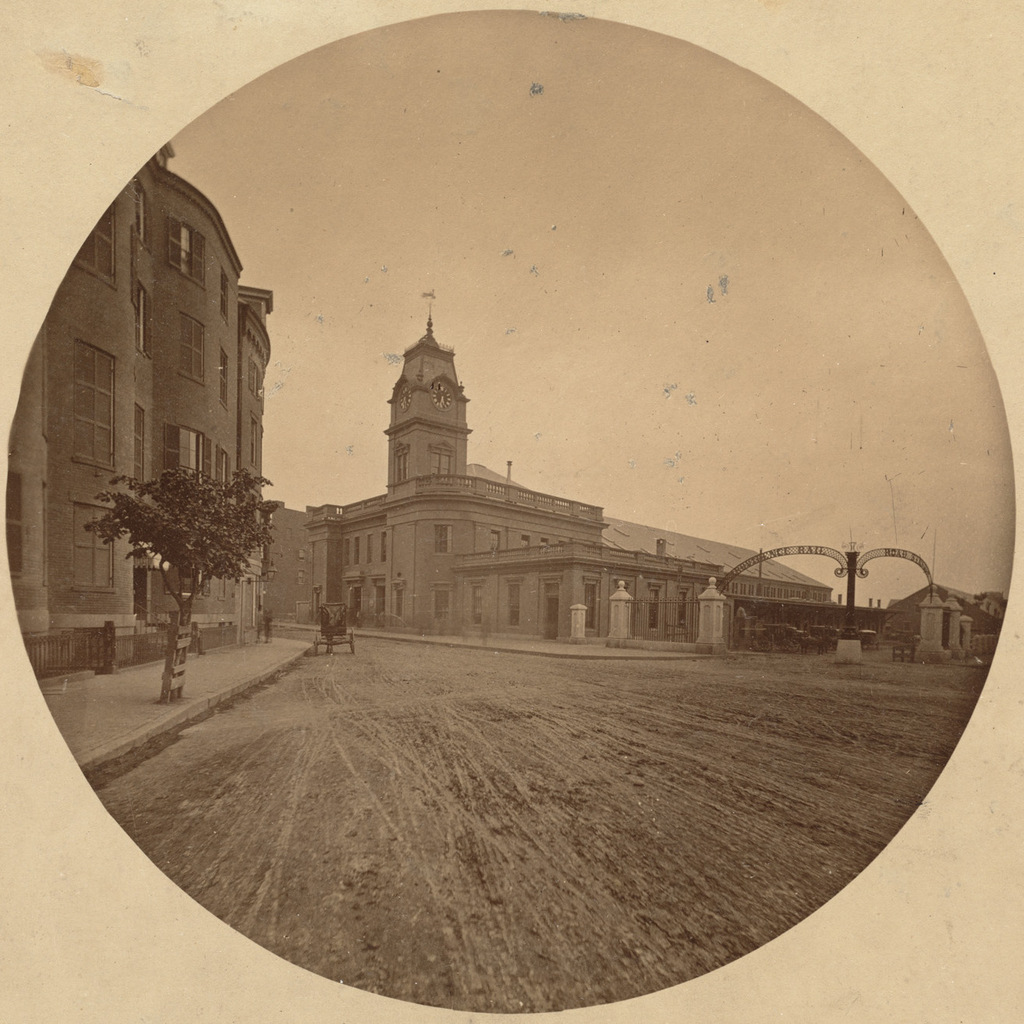
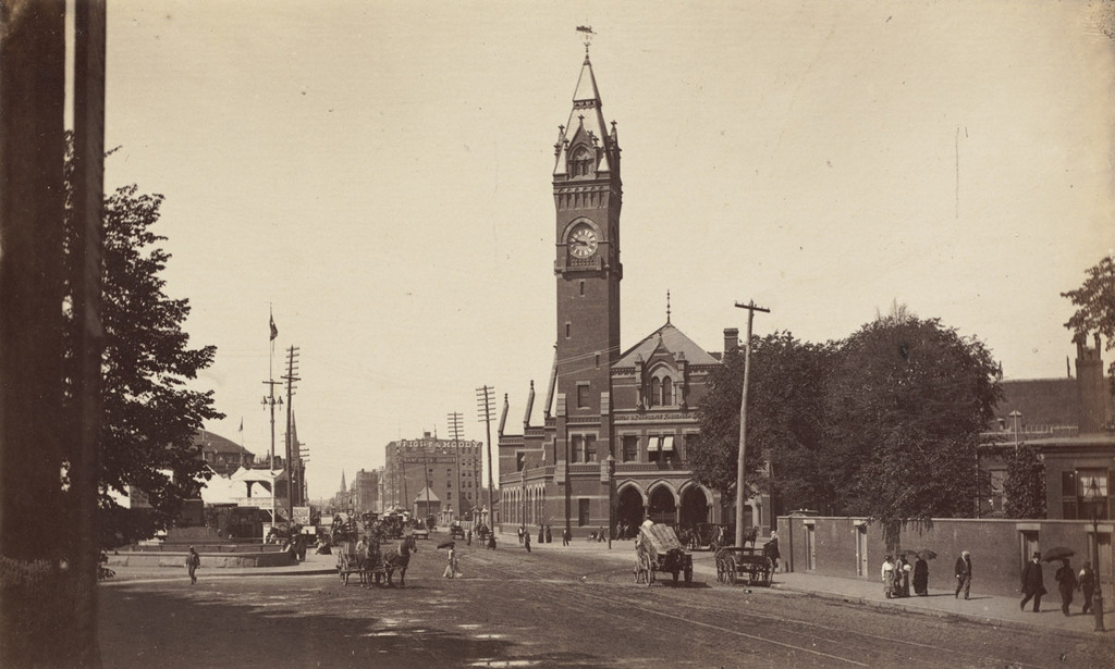
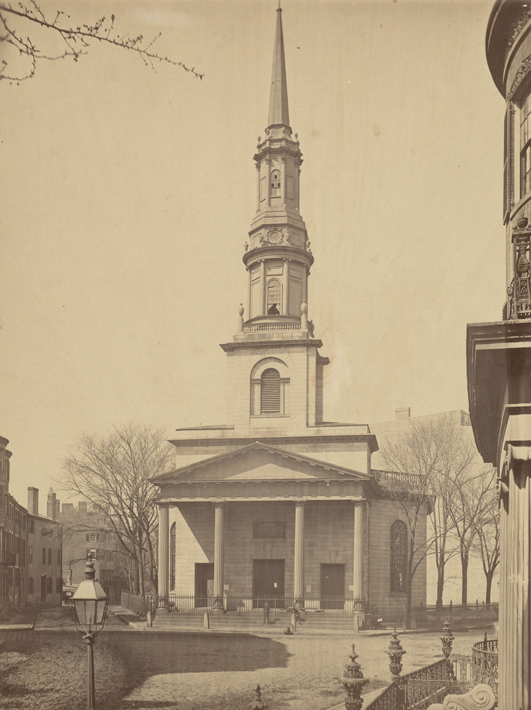
New South Church at the corner of Summer and Bedford Streets in Boston, around 1855-1868. Image courtesy of the Boston Public Library.
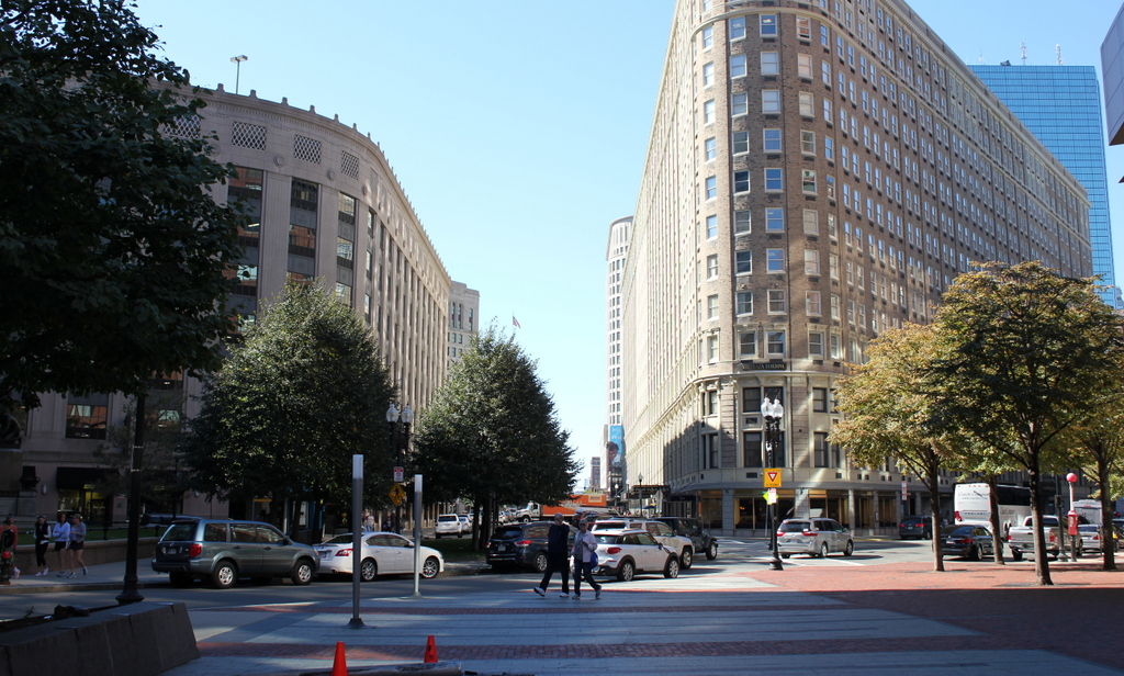
817_1855-1868c bpl

The scene in 2015:

817_2015
Not to be confused with the Old South Meeting House, or the New Old South Church, this church at the corner of Summer and Bedford Streets was known as the New South Church. It was octagonal in shape and made of granite, and it was designed by Charles Bulfinch, a prominent early American architect who designed a number of buildings in Boston, including the Massachusetts State House, the expanded Faneuil Hall, and Boylston Market.

When the church was completed in 1814, this neighborhood in the present-day financial district was an upscale residential area. A few block away on Franklin Street was Bulfinch’s famous Tontine Crescent, and here on Summer Street there were also a number of high-end townhouses. Daniel Webster lived in a house at the corner of Summer and High Street, just a few steps back from where these photos were taken, and although he died before the first photo was taken, this would have essentially been the view he would have seen whenever he left his house.

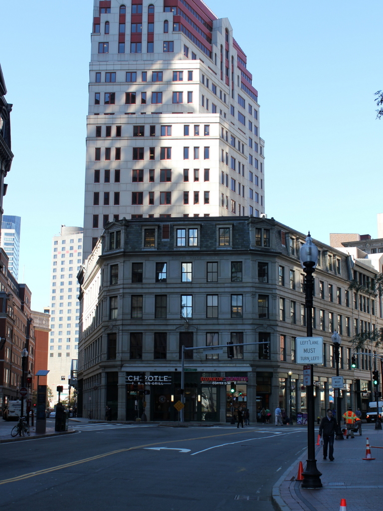
By the 1860s, though, Boston was running out of land, and this area was eyed for redevelopment. Most of the townhouses were taken down as the neighborhood shifted from residential to commercial, and in 1868 the New South Church was also demolished and replaced with a bank. The new building didn’t last long, though; it was destroyed in the Great Boston Fire of 1872, and the present-day Church Green Building was completed the following year. Although the historic church is long gone, its eventual replacement has become historic in its own right. Despite being in the heart of the Financial District, it has survived for nearly 150 years, and it is now listed on the National Register of Historic Places.

Boston and Providence Depot, Boston

The Boston and Providence Depot at Park Square in Boston, around 1860. Image courtesy of the Boston Public Library.

815_1860c bpl

The station around 1885. Image courtesy of the Boston Public Library.

815_1885c bpl

The scene in 2015:

815_2015

The Boston and Providence Railroad opened in 1835, at a time when Boston was still a peninsula connected to the mainland by a narrow isthmus. To avoid taking up scarce land, the railroad built a long trestle across the Back Bay, which at the time was a tidal marsh between Boston and Roxbury. The railroad terminal was built here at the edge of the water, at what eventually became Park Square.

The original station from the first photograph was demolished in the early 1870s so that the city could build Columbus Avenue, and it was replaced with the much larger station in the second photograph. In advertisements, it was hailed as “The Palace Depot of the World,” and from here passengers could board a train for Providence, New York, and other points south. However, by the late 19th century there were eight different railroads serving Boston, each of which operated its own separate station. The four railroads on the north side all had terminals near where North Station would be be built in 1893, and three of the south side terminals were located in the immediate vicinity of today’s South Station. The Providence and Worcester depot was the one outlier; it was on the south side, but it was a half mile away from the next closest station.

Because the multiple stations were both inconvenient for passengers and a waste of valuable property, the four south side railroads finally consolidated into South Station in 1899. This station and the tracks leading to it were closed, and the railroad, which by then had been leased to the New York, New Haven and Hartford, was rerouted onto new tracks, parallel to the Boston & Albany Railroad.

Today, none of the buildings from the first two photos are still standing. The site of the station is now the Boston Park Plaza Hotel, which was built in 1927 as the Hotel Statler Boston in the triangular block between Columbus Avenue, Park Plaza, and Arlington Street. The only visible remnant from the first photo is the Emancipation Memorial statue, which was added to Park Square in 1879 and can be seen on the far left of both photos.


Downtown Monson, Mass

Looking north on Main Street in Monson from near Lincoln Street, in 1860. Image courtesy of the Monson Free Library.

759_1860 mfl

The scene in 2015:

759_2015
The first photograph is among the earliest known images of Monson, and it shows a town in transition.  Founded 100 years earlier, Monson’s development had been largely limited by geography.  The town center, seen here, is located in a narrow valley with steep hills on either side, making large-scale farming impractical and transportation difficult.  However, 10 years before the first photo was taken, a railroad was built through the town, just out of view to the left.  This helped to spur industrial development, and in the second half of the 19th century the town’s population and economy grew thanks to a granite quarry, along with factories that produced textiles and hats.

When the 1860 photo was taken, this section of Main Street was still mostly residential, but by the end of the century many of these homes would be demolished and replaced with commercial buildings, especially the older homes in the foreground.  Other late 19th century changes included several new churches.  The old meeting house, whose steeple can be seen in the distance to the left, was replaced by a larger church in 1873, and in 1889 the Universalist church was built at the corner of Main and Lincoln Streets; it can be seen to the left in the 2015 photo, partially hidden by the tree in the foreground.

Despite all of the changes over more than 150 years, there are several buildings from the first scene that are still standing today.  The most obvious is the Methodist church, which was built in 1850 at the corner of Main and Cushman Streets.  Today, aside from a new steeple, it still looks essentially the same as it did in the 1860 photo.  Further up Main Street, many early 19th century houses are still standing today, but only a couple are readily identifiable in the 1860 photo.  The fourth house on the left is now the Unitarian-Universalist church parsonage, and it is located just beyond the present-day church and out of view from here.  Beyond it on the far left is the Joel Norcross House, which had been built around 30 years earlier by Emily Dickinson’s grandfather.  It is also hidden from view in the 2015 scene, but it is still standing and has since been converted into business and office space.

Old Meeting House, Monson, Mass

The old meeting house of the First Church of Monson, seen around 1860-1871. Image courtesy of the Monson Free Library.

755_1860-1873c mfl

The church in 2015:

755_2015
The First Church of Monson was established in 1762, and the first photo here shows its second meeting house, which was completed in 1803.  The building stood here on High Street, overlooking downtown Monson, until 1871, when it was moved across Main Street and the present-day church was built.  Its time in use coincided with the lengthy pastorate of Alfred Ely, who served as the pastor of the church for 60 years, from 1806 until 1866.  After the building was moved, it was converted into stores on the first floor and a meeting hall on the upper floor, named Green’s Hall.  It can be seen in the c.1892 photo in this post, but it burned down in 1895.  The church building that replaced it, though, it still standing over 140 years later, and aside from having its steeple replaced twice, it looks essentially the same as it did when it was completed in 1873.

Portland Head Light, Cape Elizabeth, Maine (3)

Another view of Portland Head Light, probably taken around the 1870s. Image courtesy of the New York Public Library.

741_1865-1883c nypl

The lighthouse in 2015:

741_2015
The first photo here was probably taken around 10-20 years before the ones in the previous two posts here and here, and it shows the tower as it appeared following its 1865 height change.  As mentioned in more detail in the first post, the lighthouse was built in 1791, but was reduced in height by 20 feet in 1812, to the spot below the lantern where a horizontal band runs around the tower.  Those 20 feet were restored in 1865, as seen in the first photo, but the tower was trimmed down again in 1883.  Just two years later, though, enough sailors complained that it was raised 20 feet yet again, with changes such as a larger lantern room at the top and  a second gallery below it.  Since 1885, it hasn’t seen very many changes, and it remains an active lighthouse as well as a popular tourist destination along the southern coast of Maine.

John Brown’s Fort, Harpers Ferry, West Virginia

The fire engine house at the Harpers Ferry Armory, more commonly referred to as “John Brown’s Fort,” as seen around 1860. Image courtesy of the Library of Congress, Civil War Collection.

732_1860c loc

The same view in May 1939. Image courtesy of the Library of Congress, FSA/OWI Collection.

732_1939-05 loc

The scene in 2015:

732_2015 loc
This small, seemingly nondescript building was built in 1848 at the entrance to the Harpers Ferry Armory, and was used as a guard house and fire engine house.  Normally, such a building would not be the subject of an 1860s stereocard, but it gained widespread fame just a few years earlier, due to its role in John Brown’s raid on the armory.

On October 16, 1859, northern abolitionist John Brown led a group of 22 men who attempted to take the armory and start a slave rebellion. They succeeded in taking the armory, and took a number of Harpers Ferry citizens hostage, but the plan quickly unraveled and they ended up barricading themselves in this building, surrounded by local militiamen and other armed townspeople.  Eventually, Colonel Robert E. Lee, still fighting in the US Army at the time, led a detachment of Marines, who succeeded in taking the building and capturing John Brown and most of his men.

To many northern abolitionists, John Brown was a hero, but to southern slaveowners he was a dangerous radical and a criminal. He was executed on December 2 in nearby Charles Town, but the failed raid helped to set the Civil War in motion a little over a year later.  The first photo was probably taken within three years of the raid, and in it the building still bears some of the scars from the fight.

Unlike most of the armory buildings, this one actually survived the war, and over time it became a tourist attraction and a symbol of the abolitionist movement. However, many residents feared that it would become a major draw for African-Americans to visit the town, so they were looking for ways to get rid of it.  Finally, in 1891 the owners decided to dismantle the fort and reassemble it at the World’s Columbian Exposition in Chicago.  It was a colossal failure at the exposition, though; the move cost $60,000, and just 11 people paid the 50 cent admission fee to view the fort.

The fort underwent further dismantlings and reconstructions, before eventually moving to its present-day site about 150 feet to the right of here.  However, it doesn’t have much real historic value, because of the number of times it has been reconstructed and the amount of original materials that has been lost over time.

After the fort was moved from here, the Baltimore & Ohio Railroad built new railroad embankments through the site of the fort, so today it is at a substantially higher elevation than it was in the first photo.  The monument, seen in the last two photos, was added by the railroad and marks the original location.