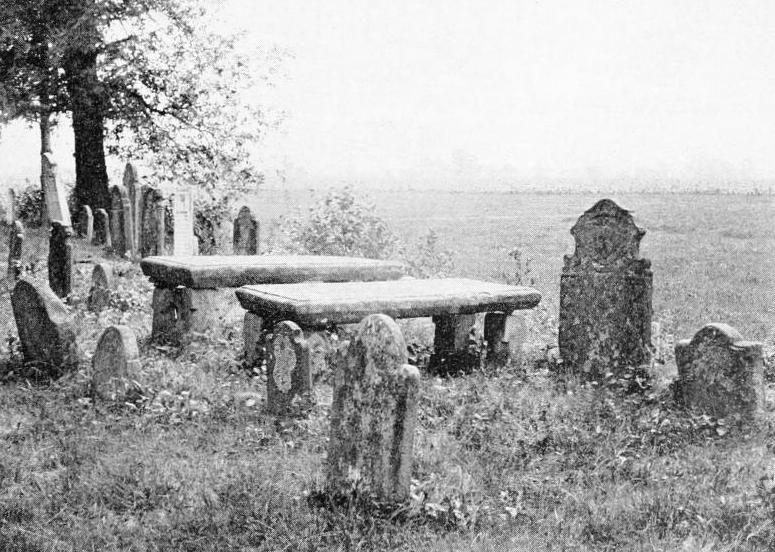
Gravestones at Old Hadley Cemetery, around 1905. Image from History of Hadley (1905).
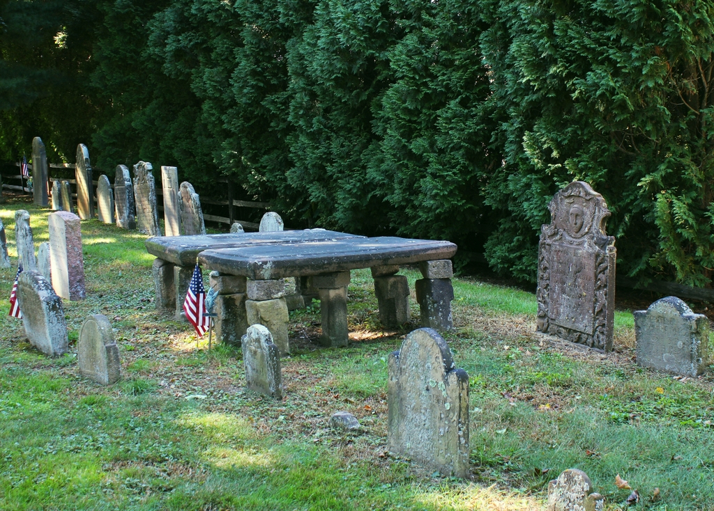
The scene in 2021:
Hadley was settled by European colonists in 1659, and incorporated as a town in 1661. Around the same time, this burying ground was laid out in a meadow just to the northwest of the town center, with the earliest known burials dating back to 1661. Among these was John Webster (1590-1661), who had served as governor of Connecticut before relocating to Hadley. As was the case for most of the other 17th century burials here, his grave was not marked by a stone, although a monument to him was installed in the cemetery in 1818 by his great-great-great grandson Noah Webster, the famous lexicographer and dictionary author.
The earliest surviving gravestones in the cemetery are two matching tablestones for Rebecca and John Russell. They died in 1688 and 1692, respectively, and their stones were installed in 1693, although they are not visible in this particular scene. Otherwise, though, gravestones were rare here until the 1710s, when Hadley resident Joseph Nash began carving gravestones. He used tan sandstone, and his gravestones were typically small, irregularly shaped, and with crudely-cut lettering. Despite the primitive appearance of the stones, he was evidently popular because his work appears in most of the early burying grounds in the Connecticut River Valley of Massachusetts. Several of his stones are visible in this particular scene, including those of Mehetebel Marsh (1694-1739) on the far right, and Aaron Cook (1641-1716) and Sarah Cook (1644-1730) near the foreground on the far left side.
The two large tablestones in the center of this scene are for Joanna Porter (1665-1713) on the left and her husband Samuel Porter Jr. (1660-1722) on the right. Joanna was the daughter of Aaron and Sarah Cook, and she was also the mother of Mehetebel Marsh, so this was evidently their family plot. Tablestones were relatively uncommon because of the high cost, and were typically only used for clergymen and other prominent town residents. In this case, Samuel Porter was a wealthy merchant, and he also served as a representative in the colonial legislature, and as a judge and county sheriff. The Porter tablestones were not carved by Joseph Nash, as this was likely seen as too costly of a job to leave to a rather amateurish local stonecutter. Instead, these stones appear to have been carved by the Stanclift family in Middletown, Connecticut, who specialized in monuments such as these.
The Mehetebel Marsh gravestone was likely one of the last that Joseph Nash carved before his own death in 1740. By this point, gravestones in Western Massachusetts were starting to become more refined, in part because of an increased number of stones brought up the river from the skilled Middletown-area carvers. Among these was the gravestone of Samuel Porter III (1685-1748), the tall stone just to the right of the tablestones. He was the son of Samuel and Joanna, and although he died less than a decade after his sister Mehetebel, their two gravestones show the vast differences in skill level between local carvers like Nash and the professionally-trained carvers of Middletown. His gravestone was carved by the prominent Johnson family of Middletown, and its design suggests that it may have been carved somewhat later, perhaps in the 1750s or early 1760s.
The carvers from the Johnson family dominated the gravestone business along the Connecticut River Valley during the mid-1700s, but there were also some skilled local carvers who emerged in Western Massachusetts during this period. Foremost among them was Nathaniel Phelps of Northampton, who was active from the 1740s until the 1780s. Aside from Joseph Nash, perhaps no other 18th century carver is better represented here in Hadley, and one of his gravestones stands in the lower center of this scene, marking the grave of Joanna Porter’s brother Samuel Cook (1672-1746). This stone is a close imitation of the Johnson family’s style, but Phelps would subsequently develop his own style, and he occasionally carved highly ornate gravestones that featured full-body figures of angels. Among these was the gravestone of Sarah Porter (1741-1775), the wife of Samuel and Joanna’s grandson Elisha Porter. Her gravestone is visible in the background of this scene; it is the fourth one from the left in the back row.
By the early 19th century, gravestone styles had shifted away from the ornate carvings of the 18th century. Instead, these gravestones tended to either have generic designs of willows and urns, or no images at all. And, rather than sandstone, these 19th century stones were typically carved in slate or marble. Most of these burials were further to the east of the original section of the cemetery, but there are several 19th century marble stones here in the old section, including one in the back row in the distance for Nathaniel Porter (1709-1779). Although he died in 1779, the style of his gravestone suggests that it was probably carved at some point in the first half of the 1800s.
Aside from Nathaniel Porter’s backdated gravestone, perhaps the most recent gravestone in this particular scene is that of Elisha Porter (1742-1796). Like his grandfather Samuel had done many years earlier, Elisha served as sheriff of Hampshire County, and he was also a colonel in the state militia during the American Revolution. His gravestone is carved in marble, and it has a fairly plain design that is decorated only with an urn in the upper part of the stone.
More than a hundred years would pass between Porter’s burial in 1796 and when the first photo was taken at the turn of the 20th century. It is hard to say to what extent this scene changed during that time. Colonial-era burial grounds were often laid out in a somewhat haphazard manner, and during the 19th century many were rearranged into orderly rows of gravestones, often with little concern for whether the stones on the surface corresponded to the remains underground. This was often done for aesthetic reasons or to make maintenance easier, but it seems unclear whether it happened here in Hadley. However, the 18th century gravestones here are all arranged in parallel rows, suggesting that perhaps their positions may have been adjusted at some point.
Today, nearly 120 years after the first photo was taken, the background of this scene has changed significantly. Rather than the open meadows of the first photo, there is now a house directly to the west of the cemetery, with a tall hedge marking the property line. However, here in the foreground the cemetery has remained remarkably unchanged during this time. Sandstone gravestones are often vulnerable to weathering and erosion, and many in the river valley are badly deteriorated, especially those from the Middletown area. Here in Hadley, though, the stones have generally remained well-preserved, and this cemetery is one of the finest colonial-era burial grounds in Western Massachusetts.