Loomis Homestead, Windsor, Connecticut

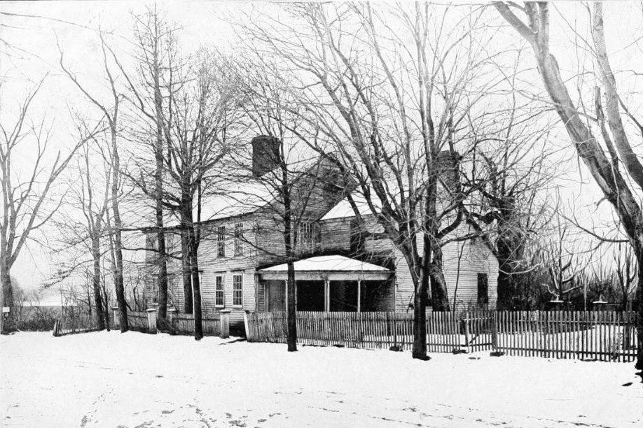
The Loomis Homestead, on the present-day campus of the Loomis Chaffee School in Windsor, probably taken around the turn of the 20th century. Image from Descendants of Joseph Loomis in America (1908).

The house around 1935-1942. Image courtesy of the Connecticut State Library.
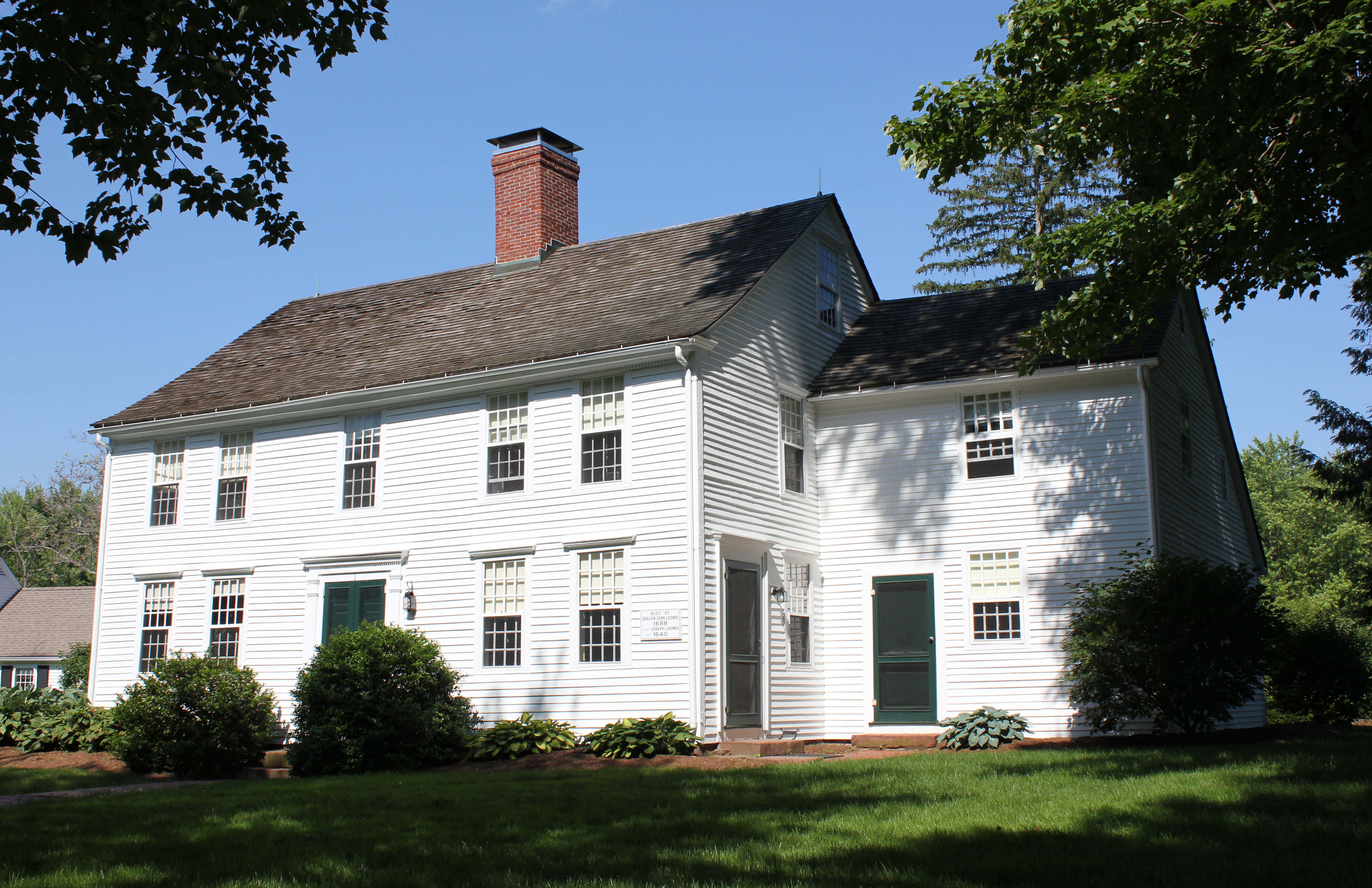
The house in 2017:

Built sometime between 1640 and 1652, this house is the oldest in Windsor, dating back to the first few years of the town’s settlement, and it is also among the oldest existing buildings in the country. The house was significantly expanded later in the 17th century, but the oldest section – the ell on the right side – was built by Joseph Loomis, one of Windsor’s original settlers and the patriarch of the Loomis family in America. Loomis was originally a woolen draper in Braintree England, but in 1638 he emigrated to the American colonies, along with his wife Mary and their eight children.

After a three-month voyage aboard the Susan and Ellen, the Loomis family arrived in Boston, and they lived nearby in Dorchester for the next year. However, in 1639 they joined a number of other Massachusetts colonists and relocated to the Connecticut River Valley. The following year, Joseph was granted 21 acres of land here in Windsor, located along the south side of the Farmington River, just to the west of its confluence with the Connecticut River. He built this house soon after, on a section of raised land that was known as “The Island,” because the surrounding meadows would often flood during spring freshets, effectively making the property an island.

Mary Loomis died in 1652, and Joseph in 1658, and their son John inherited the property. He had been about 16 years old when he and his family left England, and he lived here in Windsor until 1652, when he moved to Farmington. However, he moved back to Windsor in 1660, where he became a distinguished town citizen. He served as a deacon in the church, and he also represented the town in the Connecticut General Court from 1666-1667 and 1675-1687. John and his wife Elizabeth had eleven sons and two daughters, although only eight of their children would live to adulthood. Their only surviving daughter, Elizabeth, married Peter Brown, and they had a son, John Brown, who would become the great-grandfather of the prominent abolitionist of the same name.

According to the sign on the house, as well as other historical records, John Loomis built the main part of the house in 1688. He died the same year, but this addition was probably built for his son Timothy, who inherited the house and married his wife Rebecca the following year. They raised seven children here, and the youngest, Odiah, inherited the house. Odiah lived to be 88 years old, and after his death in 1794 he left the house to his son Ozias, who died two years later.

Ozias Loomis’s son, Odiah, was 12 years old when his father died, and he subsequently inherited the property, becoming the sixth consecutive generation to own this house. He and his wife, Harriet Allyn, had seven children, and, like his great-great grandfather Timothy Loomis, he represented Windsor in the state legislature, serving in 1818. However, he died in 1831 at the age of 48, and his youngest child, Thomas, inherited the house. Like his father, Thomas would also go on to be elected to the state legislature, serving in the lower house in 1857 and 1862, and in the state senate in 1874.

Census records from the late 19th century show Thomas Loomis as a prosperous farmer, with $20,000 in real estate in 1880. This included over 200 acres, although most of this was listed as unimproved woodland. He had 58 acres of meadows and orchards, and only two acres of tilled land, but in the year prior to the 1880 census his farm had produced 100 tons of hay, 624 pounds of butter, 800 dozen eggs, 80 bushels of potatoes, and 25 bushels of apples.

Thomas and his wife, Mary Jane Cooke, had two children, Allen and Jennie, although Allen died in 1884 at the age of 23. As a result, Jennie inherited the family homestead after her father’s death in 1895, becoming the eighth generation to own the house. However, Jennie was unmarried and had no surviving siblings, so in 1901 she transferred the house to the Loomis Institute, a private school that had been established in 1874 by five siblings from a different line of the Loomis family. The school itself would not open until 1914, but it was to be located here on “The Island,” where Joseph Loomis had originally settled in the 1640s.

The campus Loomis Institute, which later became the Loomis Chaffee School, was built just to the south of this house. Under the conditions of Jennie Loomis’s transfer of the house, she and her mother were allowed to live here for the rest of their lives. Mary Jane died in 1920, but Jennie was still living here when the second photo was taken around the late 1930s. She was actively involved with the school, serving as secretary of the Board of Trustees, and she lived here in this house until her death in 1944, about three centuries after Joseph Loomis had built the house.

The main section of the house underwent renovation in 1940, which included restoring the interior wood paneling to its original appearance. About a decade later, the older section was restored on both the interior and exterior, with the most noticeable change being the removal of the porch on the right side of the house. Otherwise, the exterior of the house has not significantly changed, and it remains a well-preserved example of 17th century saltbox-style architecture. It is still owned by the Loomis Chaffee School, and it stands as the oldest wood frame house in Connecticut, and the state’s second-oldest surviving building, after a stone 1639 house in Guilford.

William Street, Springfield, Mass

Looking east on William Street from the corner of Main Street in Springfield, sometime around 1902-1915. Image courtesy of the Longmeadow Historical Society.

William Street in 2017:


William Street, located in the South End of Springfield, was developed around the middle of the 19th century, as development of Springfield’s downtown area steadily moved southward. The area around this site had once belonged to Alexander Bliss, who operated a tannery on the site. His son, Elijah, inherited his father’s large estate after his death in 1843, and began subdividing the property. The 1851 city map shows a number of buildings here, all owned by Elijah, although the ones in the first photo were probably not built until around the 1860s or early 1870s.

The houses in the first photo were primarily rowhouses, with a larger wooden apartment block further in the distance and a few single-family homes interspersed among the larger buildings. The rowhouses feature Second Empire-style architecture, with the distinctive mansard roofs on the third floor, but their designs also incorporate elements of the earlier Italianate style, such as the curved window lintels and the decorative brackets under the eaves.

The South End has long been home to a variety of immigrant groups, many of whom were living here when the first photo was taken in the early 20th century. The 1910 census shows many different working-class residents living here in apartments and lodging houses, including French-Canadian and Irish immigrants along with native-born Americans. The house on the right side, for example, was a lodging house that was owned and operated by Abbie E. Neale, a 49-year-old widow who also owned the smaller house behind it. She rented the property to 14 lodgers, which included a mix of single people and married couples who were mostly in their 20s and 30s. They held a variety of working-class jobs, including several painters, a hotel bellman, a cotton mill spinner, and a machine shop laborer.

Around the corner on William Street, the three brick rowhouses on the left side of the photo were rented by three French-Canadian families during the 1910 census. The house closest to the camera, at 169 William Street, was rented by Ovide and Elmina Bouley, immigrants from Quebec who lived here with their infant daughter and Elmina’s father. The middle house was rented by Onesime Grise, a 65-year-old French-Canadian widow who lived here with her brother-in-law, three of her sons, her widowed daughter-in-law, and her young grandson. Furthest from the camera, the last of the three rowhouses was rented by another French-Canadian widow, 58-year-old  Alphonsie Archambeau. According to the 1910 census, she had 12 children, only one of whom was still alive. This child, 17-year-old Eva Tatro, was living here at the time, as were three lodgers who rented rooms from Alphonsie.

In the years after the first photo was taken, the South End shifted from predominantly French-Canadian to Italian, a legacy that remains in the neighborhood today, with many Italian restaurants, shops, and bakeries. However, none of the buildings from the first photo are still standing here. The brick ones in the foreground appear to have been demolished prior to the late 1930s, because they were not among the buildings photographed as part of the 1938-1939 WPA project. The wooden apartment building in the distance was still standing at the time, but it has also since been demolished, and today this side of William Street is now primarily vacant lots, with a parking lot here at the corner.

Grenada Terrace, Springfield, Mass

Looking east on Grenada Terrace from Dickinson Street in Springfield, sometime in the early 1900s. Image courtesy of Jim Boone.

The scene in 2017:

The Forest Park neighborhood of Springfield was very sparsely developed up until the 1890s, when trolley lines were built through the area, providing a direct connection to downtown Springfield. This section of Forest Park, just to the northeast of the “X”, was developed by the Sumner Avenue Heights Company, and featured streets with names associated with warm climates, such as Ventura, Sorrento, and Pomona. The centerpiece of this development was Grenada Terrace, which was built parallel to Sumner Avenue and featured a wide street with a landscaped median.

The street itself was laid out by the late 1890s, but none of the houses were built until the first decade of the 20th century. Nearly all of the homes had been completed by 1910, and the first photo was probably taken around this time. Most of these homes were owner-occupied, and the 1910 census shows residents with a wide range of middle-class professions, including a clerk, contractor, building inspector, stenographer, traveling salesman, and an Armory employee.

A century later, nearly all of these homes are still standing, although most have been altered with modern changes such as enclosed porches and artificial siding. Two brick apartment buildings, visible in the distant left of the 2017 photo, were built in the 1910s, but the neighborhood remains predominantly single-family, two-family, and three-family homes. Otherwise, the only significant change to this scene is the left side, where four of the homes were demolished to make a parking lot for the Holy Name Church, which is partially visible on the far left.

Westminster Street from State Street, Springfield, Mass

Looking north on Westminster Street from State Street in Springfield, probably around 1900-1920. Image courtesy of Jim Boone.

The scene in 2017:


About 50 years before the first photo was taken, this section of State Street was only sparsely settled, with very little development to the east of the Armory. This site here, on the north side of State Street, was the approximate location of a farmhouse that was owned by Josiah W. Flagg, who owned 22 acres of land behind the house. Located about a mile and a half from Main Street, and separated from it by a steep hill, this part of the city was hardly desirable real estate, but this began to change in 1870, when the Springfield Street Railway began operation, with a horse-drawn trolley line extending as far as Oak Street.

That same year, dry goods merchant John McKnight entered the real estate business, and purchased the Flagg farm. Along with his brother William, he subdivided the property and laid out four streets between State and Bay Streets, including Westminster Street, as seen here. Thanks in part to the economic recession following the Panic of 1873, development was slow for the first decade or so, but it construction of new homes picked up in earnest by the early 1880s. Most of the houses on this block of Westminster Street were built between 1880 and 1891, with Queen Anne style architecture that appealed to popular tastes of the era.

In contrast to the modest, middle class homes on the side streets, the houses on State Street were much larger, and were built for some of the city’s most prominent residents. The house on the far left of this photo was built for William McKnight in the early 1870s, although he later moved to a different house on Worthington Street. On the opposite side of the photo, this house was built in 1871 for insurance agent Henry K. Simons. However, the house was later remodeled in 1894 for Noyes W. Fisk, an industrialist who worked as the clerk and treasurer of the season Manufacturing Company, and later established the Fisk Rubber Company. The house’s large gambrel roof was probably added during this renovation, and it disguises the fact that the house is actually several decades older than it appears.

About a century after the first photo was taken, much of the McKnight neighborhood remains remarkably well-preserved. However, this section of Westminster Street has lost a number of houses over the years, particularly on the left side of the street. The old William McKnight house on the far left was demolished around the early 1920s to build and an automobile service station that is still standing today. Just beyond it, two highly ornate Queen Anne-style homes have also been demolished, and were replaced with plain multi-family homes.

Further down the street, there are other vacant lots where houses once stood on both sides of the street, but many of the historic homes are still standing, including most notably the house on the far right. Now a funeral home, it is one of the last of the 19th century mansions on State Street, and despite the 1890s alterations it is also one of the oldest homes in the McKnight neighborhood. Today, this neighborhood consists of some 800 historic homes from the late 19th and early 20th century, and they now form the McKnight Historic District on the National Register of Historic Places.

Commonwealth Avenue Mall, Boston

Facing west on the Commonwealth Avenue Mall from Berkeley Street, on November 27, 1901. Image courtesy of the Boston Public Library.

The scene in 2017:


When the Back Bay was planned in the mid-19th century, the streets were laid out in a rectangular grid pattern, with five east-west streets running the length of the development. In the middle was Commonwealth Avenue, which was made significantly wider than the others in order to accommodate a wide, tree-lined mall in the center. The house lots on this street soon became some of the most desirable in the Back Bay, and as the trees matured the street began to take on the appearance of a Parisian boulevard.

Most of the houses along this section of Commonwealth Avenue, which extends west from Berkeley to Clarendon Streets, were built in the 1860s and 1870s, in the Second Empire style of architecture that was popular during this period. Among the street’s few non-residential buildings is the First Baptist Church, which was built in 1875 and can be seen a block away on the left. The streetscape of Commonwealth Avenue also features a number of statues, including the one in the center of the photo that honors Revolutionary War hero General John Glover.

More than a century after the first photo was taken, the Back Bay has remained remarkably unchanged. Nearly all of the historic Victorian brownstone homes are still standing, and Commonwealth Avenue has continued to be the centerpiece of one of the city’s most desirable neighborhoods. Aside from the cars on the street, the only hint of the modern world in the present-day scene is the Prudential Tower, which is barely visible through the trees on the far left side of the photo.

Forest Park Avenue, Springfield, Mass

Looking south on Forest Park Avenue from near the corner of Randolph Street in Springfield, sometime in the early 1900s. Image courtesy of Jim Boone.

The scene in 2017:


For most of the 19th century, the area that would become Springfield’s Forest Park neighborhood was only sparsely settled. However, with the opening of a trolley line to the area in 1890, the southwestern corner of the city suddenly became within easy commuting distance of downtown Springfield. One of the first developers in the neighborhood was the Mutual Improvement Company, which purchased much of the land in the large triangle between Fort Pleasant, Belmont, and Sumner Avenues. A number of new streets were laid out, including Forest Park Avenue, which is seen here near the center of the development.

The Mutual Improvement Company was founded by John and William McKnight, the brothers who had been developing Springfield’s McKnight neighborhood since the 1870s. Like in McKnight, they sought to create an upscale residential neighborhood here in Forest Park that would appeal to Springfield’s leading citizens. Nearly all of the houses were unique, and were designed by some of the city’s leading architects. They also sold undeveloped lots, although these deeds came with restrictive covenants that required a specific setback from the road and a minimum construction cost.

Development in this section of Forest Park began in the early 1890s, primarily in the area between Garfield Street, Churchill Street, Sumner Avenue, and Forest Park Avenue. A few of these homes are visible in the distance, and they tend to have Queen Anne-style architecture, which was popular in the last decades of the 19th century. However, the large-scale development of this area did not begin until after 1900. At this point, architectural tastes had shifted toward Colonial Revival, as can be seen in the house on the far left, which was built in 1902. Other buildings that were completed during this second phase include the 1901 Park Memorial Baptist Church, which is visible in both photos.

About a century after the first photo was taken, the Forest Park Heights neighborhood remains remarkably well-preserved, and very little has changed in this scene on Forest Park Avenue. The only significant difference is the house on the right side of the first photo, at the corner of Garfield Street. It was built in the early 1890s, and was the home of candy manufacturer Franz Jensen. However, it was demolished in the 1930s, and was later replaced by a smaller Cape-style home in the 1940s. Overall, though, most of the historic homes in this neighborhood have survived with few major changes, and in 1982 the area was added to the National Register of Historic Places as the Forest Park Heights Historic District.