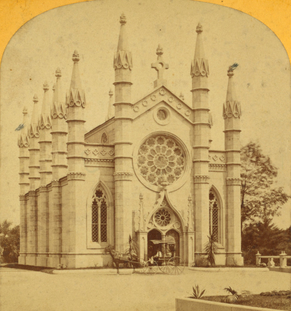
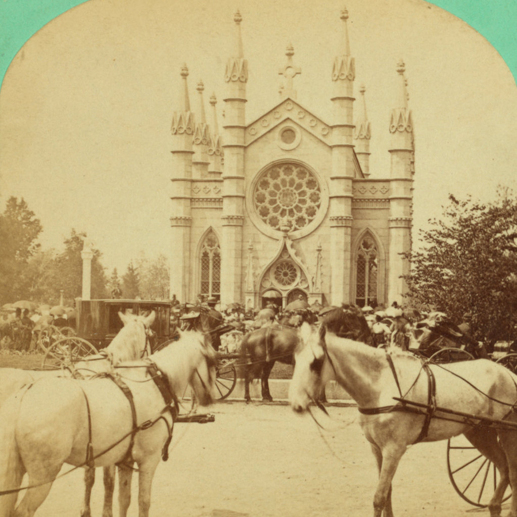
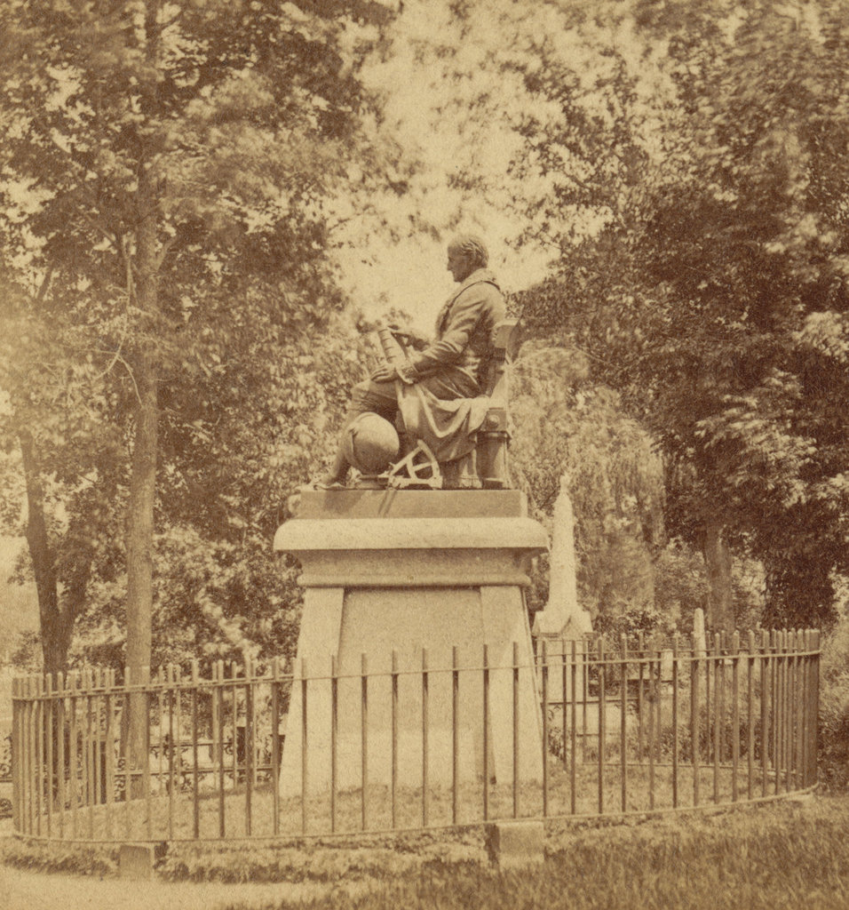
Henry Wadsworth Longfellow Gravesite, Watertown, Mass

The gravesite of Henry Wadsworth Longfellow in Mount Auburn Cemetery, around 1900-1910. Image courtesy of the Boston Public Library.
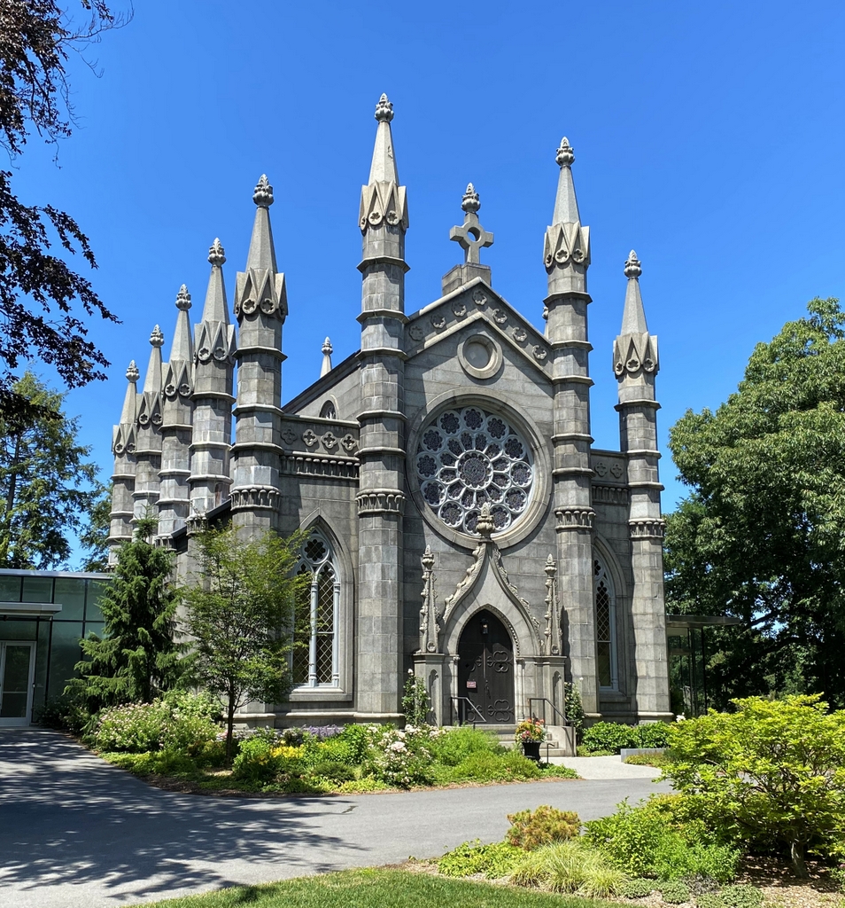
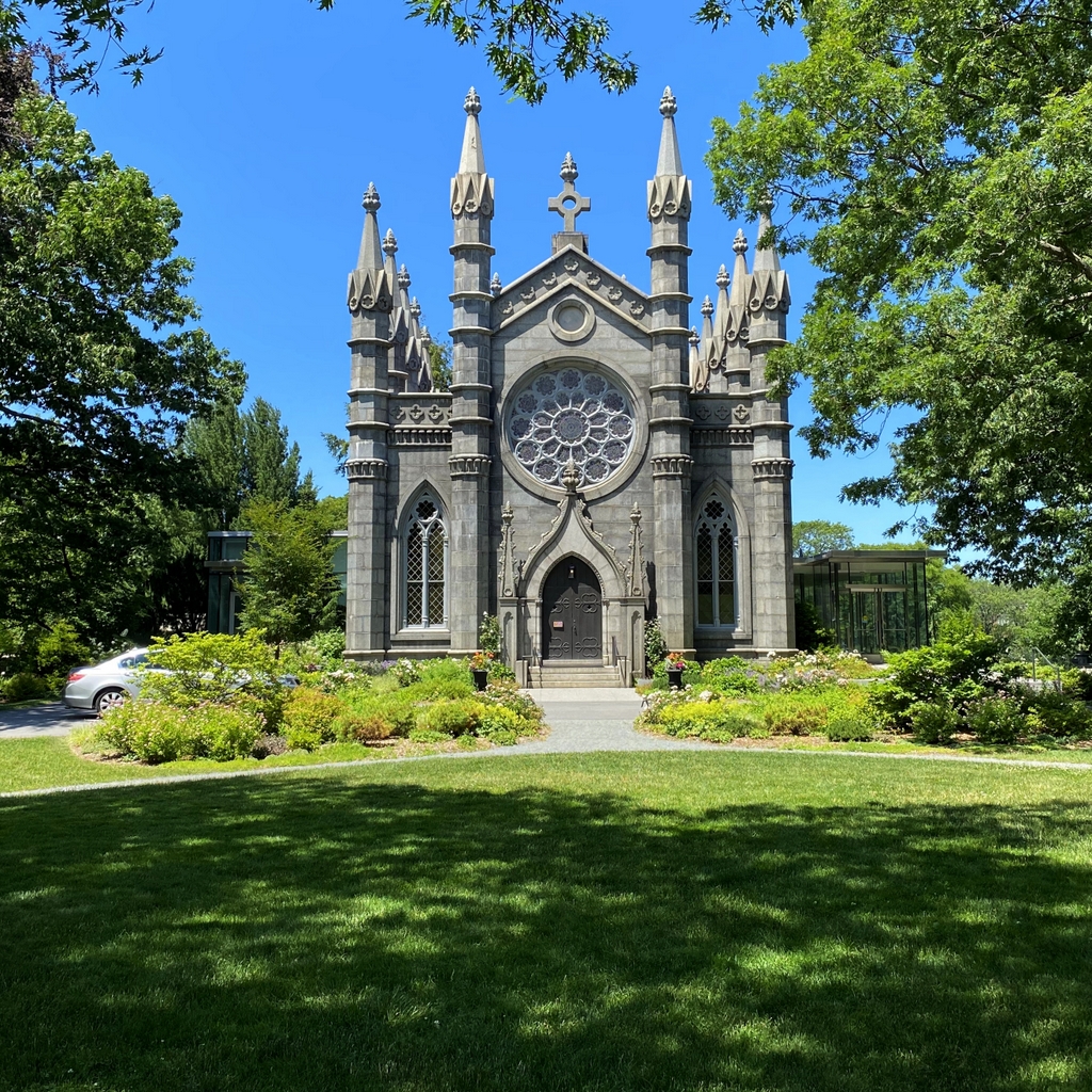
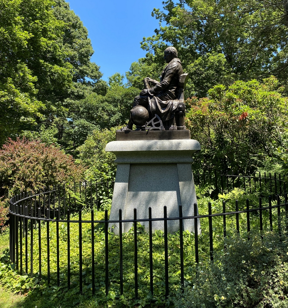
The scene in 2021:

These two photos show the final resting place of prominent 19th century poet Henry Wadsworth Longfellow and his family. Born in Portland in 1807, he later attended Bowdoin College, became a professor there, traveled abroad in Europe, and then eventually ended up in Cambridge as a Harvard professor in 1836. In the meantime, he had married his first wife, Mary, in 1831, but she died in Europe in 1835 as a result of complications from a miscarriage, and her body was returned here for burial in the newly-established Mount Auburn Cemetery.

When he moved to Cambridge after her death, he rented a room in a mansion that, more than 60 years earlier, had been George Washington’s headquarters during the Siege of Boston. He eventually purchased this house, and he lived there for the rest of his life. He remarried in 1843, to Frances Appleton, and they had six children together, one of whom died in infancy and was buried here. Unfortunately, Frances also died under tragic circumstances, when her dress caught fire while she was trying to melt wax to seal envelopes. Longfellow himself was also badly burned while trying to put out the flames, which led him to grow his beard to hide the scars.

Throughout his time in Cambridge, Longfellow was the most celebrated poet in America. Some of his most popular works included long epic poems such as Evangeline and The Song of Hiawatha, along with shorter poems, such as “The Courtship of Miles Standish,” “Paul Revere’s Ride,” and “The Village Blacksmith.” His poems often told highly romanticized versions of historical events, in many cases focusing on the colonial or Revolutionary eras.

Longfellow died in 1882 at the age of 75, and he was buried here in the family plot in Mount Auburn Cemetery, alongside his two wives and infant daughter. The first photo was taken a couple decades later, showing the family monument. It was carved out of Indiana limestone by Longfellow’s nephew, William Pitt Preble Longfellow, and on the side it features a symbol in the form of a circle with an X over it. The X is inscribed with “Dux,” “Lex,” “Lux,” and “Rex,” and the words are arranged so that they all share a small X in the center of the larger X. This Latin inscription translates to “Leader,” “Law,” “Light,” and “King.”

By the time the first photo was taken, Longfellow’s oldest child, Charles, had also been buried here. His other four children were still living at the time, but his son Ernest died in 1921, and his daughter Alice in 1928, and both were subsequently buried in the family plot. Aside from these additional interments, the only changes here have been the landscaping. The family plot is no longer covered in grass, and the trees in the distance on the hillside have grown in, but otherwise this scene is still easily recognizable more than a century after the first photo was taken.

Auburn Lake, Watertown, Mass

Auburn Lake in Mount Auburn Cemetery, around the 1870s or 1880s. Image courtesy of the New York Public Library.

The scene in 2021:

As discussed in the previous post, Mount Auburn Cemetery was established in 1831 as the first rural cemetery in the United States. Up until this point, Boston-area graveyards typically occupied small plots of land near town centers. They were a practical necessity as a place to bury the dead, with little emphasis on landscaping. Even the gravestones themselves, while often elaborately carved, served a purpose by reminding people of death and mortality.

However, by the early 19th century many of these graveyards were becoming overcrowded, especially in fast-growing places like Boston. Motivated by concerns about public health, along with shifting societal attitudes regarding death, proponents such as Dr. Jacob Bigelow advocated for a new, expansive   cemetery on the outskirts of Boston. The result was Mount Auburn Cemetery, which was laid out on the north side of the Charles River, on the border of Cambridge and Watertown,

Unlike the purely functional colonial-era graveyards, Mount Auburn was designed to be both a quiet resting place for the dead, and also a peaceful place for the living to visit in the days before public parks were common. It was carefully landscaped, with burial plots situated along winding paths, and  grounds that were interspersed with trees, hills, and ponds. Overall, the effect was a park-like setting that, to many, may have helped to soften the harsh realities of death.

These two photos show Auburn Lake, one of the three ponds in the cemetery. It was once known as Meadow Pond, but in the late 1850s it was renamed Auburn Lake. This appears to have occurred around the same time that the ponder underwent improvements, including lining the banks with stone. By the time the first photo was taken around the 1870s, Auburn Lake featured a bridge, which crossed the narrow portion between the northern and southern halves of the pond, and it also had a swan house in the center, with at least one swan visible in the photo.

Today, about 150 years after the first photo was taken, not much has changed in this scene. The swan house is long gone, but otherwise Auburn Lake looks much the same as it did in the first photo. This is due, in part, to an extensive restoration project that occurred in 1998, involving draining and dredging it, and then replanting the areas along the banks. Overall, as is the case with Auburn Lake, the cemetery still has the same park-like environment that its founders had envisioned, and it remains a quiet place in the midst of the busy inner suburbs of Boston.

Mount Auburn Sphinx, Watertown, Mass

The Sphinx at Mount Auburn Cemetery in Watertown, around 1900-1906. Image courtesy of the Library of Congress, Detroit Publishing Company Collection.

The scene in 2021:

Civil War monuments are a ubiquitous feature in towns throughout New England. Most of these were dedicated in the late 19th century, and their designs typically consist of a soldier in uniform, standing atop a pedestal that is inscribed with names of battles, patriotic sentiments, or similar statements. However, perhaps the most unusual Civil War monument in the region is the Sphinx, located here in Mount Auburn Cemetery. It was commissioned by Dr. Jacob Bigelow and designed by prominent sculptor Martin Milmore, and it was installed in 1872, on a site directly across from the cemetery chapel.

Jacob Bigelow was a prominent Boston physician who, in the early 19th century, proposed the idea of a rural, park-like cemetery on the outskirts of Boston. The result was Mount Auburn Cemetery in Watertown and Cambridge, which opened in 1831. This carefully-landscaped cemetery was a sharp contrast to the grim, overcrowded colonial-era graveyards in downtown Boston, and it served as a model for many similar cemeteries that would subsequently be opened across the region during the mid-19th century.

In the aftermath of the Civil War, Bigelow wanted to create a monument in the cemetery that would celebrate the two main accomplishments of the war: the preservation of the union, and the end of slavery. However, rather than a standard soldier-with-gun-atop-pedestal design, Bigelow envisioned a sphinx, which represented the combination of intellect and strength. He also saw this ancient symbol as being a representation of the nation’s future potential, as he explained in his remarks to the cemetery’s trustees in 1871:

It essays to express the present attitude and character of a nation perhaps as far remote in time from the building of the pyramids as was that event from the earliest constructions attempted by man. The same ideal from which, as it were, on the dividing ridge of time, has looked backward on unmeasured antiquity, now looks forward to illimitable progress. It stands as a landmark of a state of things which the world has not before seen—a great, warlike and successful nation, in the plentitude and full consciousness of its power, suddenly reversing its energies, and calling back its military veterans from bloodshed and victory to resume the still familiar acts of peace and good will to man. What symbol can better express the attributes of a just, calm and dignified self-reliance than one which combines power with attractiveness, the strength of a lion with the beauty and benignity of woman?

The resulting statue was carved of Hallowell granite, and it sits atop a base with an American water lily on the front, and an Egyptian lotus on the back. On either side is an inscription, which is written in Latin on the left side and in English on the right side. The English translation reads:

American Union preserved
African slavery destroyed
By the uprising of a great people
By the blood of fallen heroes

Despite—or perhaps because of—its unconventional design, the Sphinx appears to have been well-received by contemporary observers. Writing shortly after it was installed here, the Boston Daily Evening Transcript remarked:

The Mount Auburn Sphinx has solved her own riddle, and stands upon her everlasting base at last. She is intended to commemorate the war and the heroes it cost us, and if the peril of art in such commemoration has been the falling into a monotonous sameness and peopling New England with statues of the “private soldier at rest,” that peril has in this case been notably avoided. It is certainly unique, and certainly not grotesque. Egyptian art has long been laid under contribution for expressions of reverence for the memory of the dead.

The first photo was taken about 40 years later, showing the Sphinx at the turn of the 20th century. Since then, very little has changed here aside from the landscaping around the base of the pedestal. Mount Auburn Cemetery still has the same park-like appearance that Bigelow had worked to create, and his Sphinx remains one of its most distinctive features, along with being a remarkably innovative way of memorializing the Union soldiers of the Civil War.

Slater Mill, Pawtucket, Rhode Island (2)

The view looking upstream on the Blackstone River in Pawtucket, around the 1860s or 1870s. Image courtesy of the New York Public Library.

The scene in 2021:

As explained in more detail in the previous post, Slater Mill is often regarded as the birthplace of the Industrial Revolution in America. It was built by Samuel Slater, an English-born textile manufacturer who secretly emigrated to the United States in 1789, bringing Britain’s industrial secrets with him. Upon arrival in New York, he soon made contact with Providence businessman Moses Brown, who was searching for someone to construct British-style water frames for spinning yarn. Slater subsequently came to Pawtucket, where he worked with several local craftsmen to produce a working water-powered spinning machine.

Slater then formed a partnership with Moses Brown’s son Obadiah Brown and son-in-law William Almy. They soon outgrew their original facility, so in 1792 they constructed a wood-frame dam across the Blackstone River, shown here in the center of these two photos. Then, a year later they opened their new mill, which was two stories high and measured 40 feet by 26 feet. It would later be significantly expanded over the years, but the original 1793 section is still there. Viewed from this angle, it is in the central part of the building, directly behind the large tree in on the left side of the present-day photo.

The original mill was small compared to the massive textile factories that would soon appear alongside major rivers throughout New England, and its operations were fairly limited, but it marked an important shift in manufacturing in the United States as the first large-scale cotton mill in the country. And, despite its initial small size, it soon expanded. The first addition came in 1801, with a large wing on the north side of the building, on the left side of this scene. This was followed by a wing on the south side in the late 1810s, and then a stair tower and cupola on the west side around 1830.

In the meantime, Samuel Slater remained a partner here throughout much of the early 19th century, but he also built a number of mills of his own, in part because of conflicts with Moses Brown and William Almy here at the original mill. He finally sold his interest in the company in 1829, when an economic downturn forced him to liquidate some of his assets in order to pay his debts.

This building would continue to be operated as a cotton mill throughout most of the 19th century. It was expanded with more additions during this time, and it also housed a variety of other tenants involved in different industries. The first photo shows the building around the 1860s or 1870s, standing alongside a number of other mills that had been built along the Blackstone River by this point.

Cotton production continued here until 1895, and the mill was subsequently used for other industrial purposes into the early 20th century. It was steadily deteriorating, but in 1923 it was acquired by the Old Slater Mill Association. Over the next few years, this organization restored the building to its 1835 appearance, including the removal of the later additions. Most of the surrounding buildings were also demolished, in order to create a small park around the old mill. Only the 1810 Oziel Wilkinson mill was spared, and it still stands just out of view on the left side of this scene.

Today, both the historic Slater Mill and the original dam across the river are still here. The mill was designated as a National Historic Landmark in 1966, and it is now a part of the Blackstone River Valley National Historical Park. Slater Mill is the centerpiece of this multi-site park, and it is joined here by the Wilkinson mill and also the Sylvanus Brown House, which was moved here from a different location in the mid-20th century.

Slater Mill, Pawtucket, Rhode Island

A view of Slater Mill on the Blackstone River in Pawtucket, around 1897. Image from An Illustrated History of Pawtucket, Central Falls, and Vicinity (1897).

The scene in 2021:

This mill, located on the west side of the Blackstone River in Pawtucket, is an important landmark in the early history of the Industrial Revolution in America. The building has undergone many changes and expansions over the years, but the oldest portion—located in the central part of the building—was completed in 1793 by Samuel Slater, a British emigrant who is credited with bringing the Industrial Revolution to the United States.

The Industrial Revolution had started during the second half of the 18th century in Britain, where a series of inventors had developed ways of harnessing water power to spin thread and weave textiles. However, Britain closely guarded the details of these processes, in order to prevent foreign competition. This was also the case for the American colonies, where Britain discouraged manufacturing in order ensure that colonists purchased manufactured goods from the home country.

After gaining independence, the United States still found itself largely dependent upon British manufacturers, but many American entrepreneurs were interested in bringing these industrial innovations across the Atlantic. This was particularly true here in New England, where the region’s many fast-flowing rivers made it an ideal place for water-powered industry.

Among these early industrialists was Moses Brown, a member of a prominent family in Providence. His family had become wealthy during the colonial era as merchants and slave traders. In particular, his brother John was a notorious slave trader who continued the practice even after the federal government prohibited American ships from being used in the international slave trade. By contrast, Moses became a staunch abolitionist. He freed his own slaves, converted to Quakerism, and spoke out against both slavery and the slave trade. And, while his brother was still bringing enslaved people to America, Moses was looking to apply the new British textile manufacturing processes here in Rhode Island.

To accomplish this, in 1789 Moses established the firm of Almy & Brown, which was comprised of William Almy and Brown’s cousin, Smith Brown. Their goal was to make yarn, but they had poor-quality machinery and only limited knowledge about the manufacturing process, so it became clear that they needed someone who was familiar with the British system.

As it turned out, that person was 21-year-old Samuel Slater, who arrived in New York from England on November 18, 1789. He had been an apprentice at a textile mill in England, where he became familiar with the machinery that had been developed by inventor Richard Arkwright. In addition, he learned about the management side of the textile industry. So, by the time his apprenticeship term had ended, he not only knew how to build and maintain the machinery itself, but also how to operate a profitable factory.

However, by this point Richard Arkwright’s patents had expired, and Slater apparently believed that Britain would become too oversaturated with textile businesses. America, on the other hand, seemed to offer more potential for an aspiring young industrialist, and he knew that there were plenty of American entrepreneurs who were looking for someone with his knowledge and experience. With this in mind, he left England in September 1789, just two months after the end of his apprenticeship. Because of strict British laws against exporting machinery plans or drawings, Slater did not carry any with him, and he is said to have disguised himself as a farm laborer.

Upon arriving in New York, he soon heard of Moses Brown’s efforts to produce yarn, so he wrote to him on December 2, offering his services. Brown responded eight days later, and in his letter he explained the problem that his company faced:

We are destitute of a person acquainted with water-frame spinning; . . . As the frame we have is the first attempt of the kind that has been made in America, it is too imperfect to afford much encouragement;

He then went on to make his offer to Slater:

[W]e hardly know what to say to thee, but if thou thought thou couldst perfect and conduct them to profit, if thou wilt come and do it, thou shalt have all the profits made of them over and above the interest of the money they cost, and the wear and tear of them. We will find stock and be repaid in yarn, as we may agree, for six months. And this we do for the information thou can give, if fully acquainted with the business. After this, if we find the business profitable, we can enlarge it, or before, if sufficient proof of it be had on trial, and can make any further agreement that may appear best or agreeable on all sides.

These terms were acceptable to Slater, who traveled to Pawtucket in January 1790. However, once he arrived, he saw for himself the poor quality of the machinery, which was evidently worse than he had anticipated. Moses Brown would later tell Slater’s biographer, George S. White, that,

When Samuel saw the old machines, he felt down-hearted, with disappointment—and shook his head, and said ‘these will not do; they are good for nothing in their present condition, nor can they be made to answer.’

Slater then spent the next few months working on the machinery, with assistance from local craftsmen such as Sylvanus Brown and Slater’s future father-in-law, Oziel Wilkinson. They succeeded in constructing a water-powered spinning machine, and in April, Slater became a partner in the newly-established firm of Almy, Brown & Slater. A year later, Slater married Oziel Wilkinson’s daughter Hannah. She would go on to become an inventor in her own right, and in 1793 she became the first American woman to receive a patent when she developed a new way of making cotton sewing thread.

In the meantime, Slater’s machinery worked so well that the production of yarn soon outpaced the firm’s ability to sell it through their existing supply chains. However, once Slater and his partners began expanding into new markets, the original mill was unable to keep up with the increased demand. So, in the fall of 1791 the firm purchased this site here on the west side of the Blackstone River in Pawtucket, in order to construct a new mill. The wood-frame dam, shown here in the foreground of these two photos, was constructed in 1792, and the mill itself opened in 1793.

It was the first large-scale cotton mill in the United States, and it marked the beginning of an industry that would dominate the New England economy for more than a century. This building is still standing, in the center of these two photos, although it has been significantly expanded over the years. The original 1793 portion of the building was two stories high, and measured 40 feet long and 26 feet wide. It was built of wood, with a stone foundation, and it stood directly atop the Great Flume, which was built parallel to the river to provide water power for this mill and others further downstream.

Aside from his knowledge of textile machinery, Slater was also familiar with the management and operation of British mills, and he brought many of these innovations to America. Among these was the idea of continuous production, rather than the earlier practice of only making yarn to fill specific orders. Slater also took advantage of economies of scale, with his mill specializing in a relatively small number of products. More troublingly, though, Slater also copied the British practice of employing child laborers, and his workforce typically consisted of children between the ages of 7 and 12. However, unlike the British system, which tended to exploit orphans and other destitute children, Slater sought to develop factory villages that employed entire families. This approach, which came to be known as the Rhode Island System, involved having children produce yarn at the mill, and then have women weave the yarn into cloth at their homes.

By focusing on relatively small-scale industrial production of the yarn, along with having a decentralized weaving process, Slater’s Rhode Island System was in contrast to the subsequent Waltham-Lowell System, which would come to dominate New England textile production during the 19th century. However, despite this comparatively limited scope of manufacturing, Slater’s mill was an important first step in transitioning the new nation into a major industrial center.

Although Slater’s mill here in Pawtucket was a success, he often clashed with the other two partners in the firm, who handled the financial side of the business. After just a few years, he established his own company in partnership with his in-laws. This new mill was constructed in 1799, directly across the Blackstone River from the original mill, near the spot where these two photos were taken. At the time, the river formed the border between Massachusetts and Rhode Island, so the new mill was located in the town of Rehoboth, Massachusetts. Later in the 19th century, though, the state border would shift a few miles to the east, making the east side of the river part of Pawtucket, Rhode Island.

In the meantime, Slater retained his share of the original mill, which underwent several expansions in the early 19th century. The first of these came in 1801, when the building was expanded by 57 feet to the north, more than doubling its length. Then, in the late 1810s it was extended closer to the river, with a 40-foot addition here on the south side, followed by a stair tower and cupola on the west side around 1830.

In addition to this mill, Slater and his family opened a number of other mills in Rhode Island, Massachusetts, and Connecticut. Here in Pawtucket, he continued his partnership with Almy and Brown until 1829, when an economic downturn forced him to sell his share in the original mill, along with several of his other mills, in order to repay his debts. Despite this setback, he was able to recover financially, and upon his death in 1835 he left an estate valued at over $1 million.

Slater’s former firm here in Pawtucket subsequently became Almy & Jenkins, and the old building was later occupied by several other partnerships during the 19th century. The building itself also changed, with the construction of at least three more additions during this time. The surrounding area likewise continued to be transformed, and the waterfront of the Blackstone River became lined with other mills.

Over time, the mill came to be used by a variety of tenants. By the late 19th century, these included a bicycle shop and a manufacturer of jewelers’ tools. Alongside these uses, the building continued to produce cotton until 1895, just over a century after Samuel Slater and his partners launched the American Industrial Revolution here. The first photo was taken around this time, showing the heavily-altered mill surrounded by an assorted mix of smaller industrial buildings along the river. By this point it had become a much-photographed local landmark, but it was still in active commercial use, and it was starting to show its age.

Many of the surrounding buildings were demolished at the turn of the 20th century, but the mill remained standing. It was ultimately acquired by the Old Slater Mill Association in 1923, with the goal of preserving the building and restoring it to its historic appearance. Over the next few  years, the later additions to the mill were removed, leaving only the original 1793 section and the early 19th century wings. The resulting structure, which still stands here today, thus approximates how the mill would have looked at the time of Samuel Slater’s death in 1835.

In keeping with early to mid-20th century historic preservation trends, nearly all of the neighboring buildings were subsequently demolished. The intent was to make the mill the centerpiece of a riverfront park, but it also took away the historic character of its surroundings. Not even Samuel Slater’s house was spared in the process, although Oziel Wilkinson’s three-story stone mill was preserved. Built in 1810, it stands just out of view on the left side of the present-day scene. However, this site did have one addition later in the 20th century, when Sylvanus Brown’s house was moved here from its original location about two miles away, to save it from demolition. It was in this house that Samuel Slater spent his first night upon arriving in Pawtucket, and it is visible in the present-day scene, just to the left of the mill.

Overall, despite the many changes here, the mill and dam are still recognizable from the first photo. However, there is nothing else left from the photo; to the left of the mill is the park, and to the right of it is a parking lot. Further in the distance, on the other side of the mill, are still more parking lots, and on the right side of the scene is the tower of Pawtucket City Hall, an Art Deco building that was completed in 1936.

The mill was designated as a National Historic Landmark in 1966, and it is now part of the Blackstone River Valley National Historical Park, which focuses on the industrial history of the Blackstone River. Here in Pawtucket, the park includes the two mills and the Sylvanus Brown house, along with the original dam and associated water structures, including the Great Flume. The Slater Mill is open to the public seasonally from Thursdays through Sundays, and park rangers conduct free guided tours of the building.

Mount Toby from South Sugarloaf Mountain, Deerfield, Mass

A panoramic view looking east from South Sugarloaf Mountain in Deerfield, toward Mount Toby in Sunderland, around 1891. Image from Picturesque Franklin (1891).

The scene in 2021:

These two photos were not taken from the exact same spot, as shown by the different angles of the bridges in the lower right, but they show the same general view of the Connecticut River, the town of Sunderland, and Mount Toby in the distance. Both were taken from near the summit of South Sugarloaf Mountain, a relatively small hill that forms the southern end of the Pocumtuck Range, which is part of the larger Metacomet Ridge. Sugarloaf is best known for its dramatic views of the valley to the south, but this eastern view is also offers impressive scenery.

South Sugarloaf is often referred to simply as Sugarloaf Mountain, although it is the smaller of the two summits that comprise the mountain. However, the northern peak, while nearly 200 feet higher in elevation, has only limited views from the summit, and is rarely visited. By contrast, the southern peak has long been a popular tourist destination. Rising to an elevation of 610 feet, it is about 500 feet higher than the Connecticut River, which passes just a third of a mile from the summit.

The first photo was likely taken from the Summit House, which was built here in 1864. These types of mountaintop hotels were popular in the northeast during the second half of the 19th century, and several others were located on nearby summits on the Metacomet Ridge, including the Prospect House on Mount Holyoke and the Eyrie House on Mount Nonotuck. Even Mount Toby briefly had a tower and hotel at the summit, but the buildings burned in 1882. This was a common fate for summit houses, given their isolated locations far above water sources, and the summit house on Sugarloaf Mountain would eventually be destroyed by a fire in 1966.

Mount Toby, which towers in the distance beyond the town of Sunderland, is geologically related to Sugarloaf Mountain. It is the highest peak on the Metacomet Ridge, and at 1,269 feet it is more than twice the height of South Sugarloaf. However, as the photos show, the mountain is not a single peak. Its rugged landscape has many different summits, the highest of which is on the northern side, on the far left side of both photos.

The mountain is said to be named for Elnathan Toby, supposedly the first white settler to climb it. In the 19th century, though, the prominent geologist Edward Hitchcock criticized this rather bland name. Hitchcock, who would later serve as president of Amherst College, published a report on the state’s geology in 1841. In it, he included Mount Toby, along with Sugarloaf and a number of other peaks, as part of a list of “uncouth and vulgar names” for Massachusetts mountains. Hitchcock tended to prefer Native American names, and he succeeded in renaming several peaks, including Hilliard’s Knob, which was renamed Mount Norwottuck in a large mountaintop ceremony in 1846. He made a similar attempt on Mount Toby three years later, naming it Mettawompe in honor of the Native American chief who had sold the surrounding land to white settlers. However, unlike Norwottuck, this name didn’t stick, apparently because of local opposition among Sunderland residents, and the mountain has continued to be known as Mount Toby.

Aside from the ill-fated attempts to operate a summit house on Mount Toby during the 19th century, the mountain has remained largely undeveloped, and today it looks essentially the same as it did when the first photo was taken around 1891. The town of Sunderland has also retained much of its rural appearance, and many of the houses along Main Street are still standing, as is the 1836 First Congregational Church, which is visible on the right side of both photos. Another town landmark in this scene is the Buttonball Tree. Although not identifiable from this distance, it stands near the center of the scene in both photos, about a quarter mile north of the church. With a girth of over 25 feet, this sycamore tree is one of the widest trees in the region, and it is estimated to be over 350 years old. Overall, probably the only easily-noticeable difference in these photos is the bridge over the Connecticut River. The one in the first photo was built in 1877, and it spanned the river until 1936, when a bridge further upstream was washed away in a flood and crashed into this bridge.

In the meantime, here on South Sugarloaf, the mountain continues to offer some of the finest mountaintop views in the state. It is now part of the Mount Sugarloaf State Reservation, and there is an auto road to the summit, along with several short hiking trails. In place of the 19th century summit house, the mountain is now topped by an observation tower with several different levels of platforms.