French Protestant Church, Springfield Mass

The former French Protestant Church on Bliss Street in Springfield, around 1938-1939. Image courtesy of the Springfield Preservation Trust.

458_1938-1939 spt

The church in 2015:

458_2015

This church on Bliss Street was built in 1887 as the French Protestant Church, thanks in part to the efforts of Daniel B. Wesson, whose Smith & Wesson factory was just on the other side of Main Street from here.  Many of his workers were French-Canadian Protestants, and he wanted them to have a French alternative to the Roman Catholic church.  However, the congregation disbanded in 1909, and several other churches used the building until 1919, when it was purchased by the First Spiritualist Society, who remained at the Bliss Street location until 2013.  The property was purchased by MGM Springfield, and while several historic buildings will be demolished to build the casino, the church will be moved to a new location on the MGM property and renovated as a restaurant.

East Court Street, Springfield Mass

Looking east on East Court Street in Springfield, probably in the early 1890s. Photo from Picturesque Hampden (1892)

457_1892c picturesquehampden

The street, now called Falcons Way, in 2015:

457_2015


The land that the MassMutual Center now sits on was once the site of dozens of assorted buildings.  Along the busy and prominent Main and State Streets, one could find banks, publishers such as G & C Merriam (of Merriam-Webster Dictionary fame), and the elegant YMCA building.  However, along Dwight and East Court Streets sat less glamorous, more utilitarian buildings, including ancient colonial buildings being used as laundromats.  Here on East Court Street, most of the occupations themselves are as obsolete as the buildings that once housed them here – the signs reveal that one could procure services from wagon and carriage makers, horse shoers, and farriers (although I’m not sure what the distinction is between a horse shoer and a farrier).  Within just a couple decades, these industries would go the same way of blacksmiths and coopers, and by the 1970s all of the dozens of buildings in the four square block area would be demolished to make way for the MassMutual Center.

Memorial Chapel, Wilbraham Mass

The Methodist Church in Wilbraham, around 1903. Photo courtesy of the Wilbraham Public Library.

456_1903c wpl

The building in 2015:

456_2015

The Memorial Chapel at the corner of Main Street and Mountain Road in Wilbraham is right next to the Wilbraham & Monson Academy campus, but it wasn’t always a part of the school.  It was completed in 1870, and was the third meeting house for Wilbraham’s Methodist Society.  The society was established in 1793, and their first meeting house was used until 1835, when it was converted into a private home.  It is still standing, directly across Mountain Road; I took this photo from right in front of it.  The church in this photo was used by the Methodists from 1870 until the 1920s, when they merged with the Congregational Church to form the Wilbraham United Church.  The Academy acquired the church in the 1930s, and now uses it as a library and as a venue for concerts and all-school gatherings.

F.A. Gurney Delivery Wagon, Wilbraham Mass

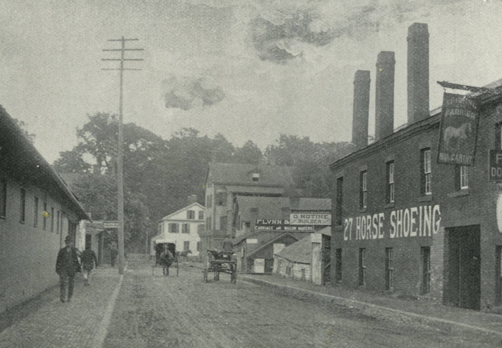
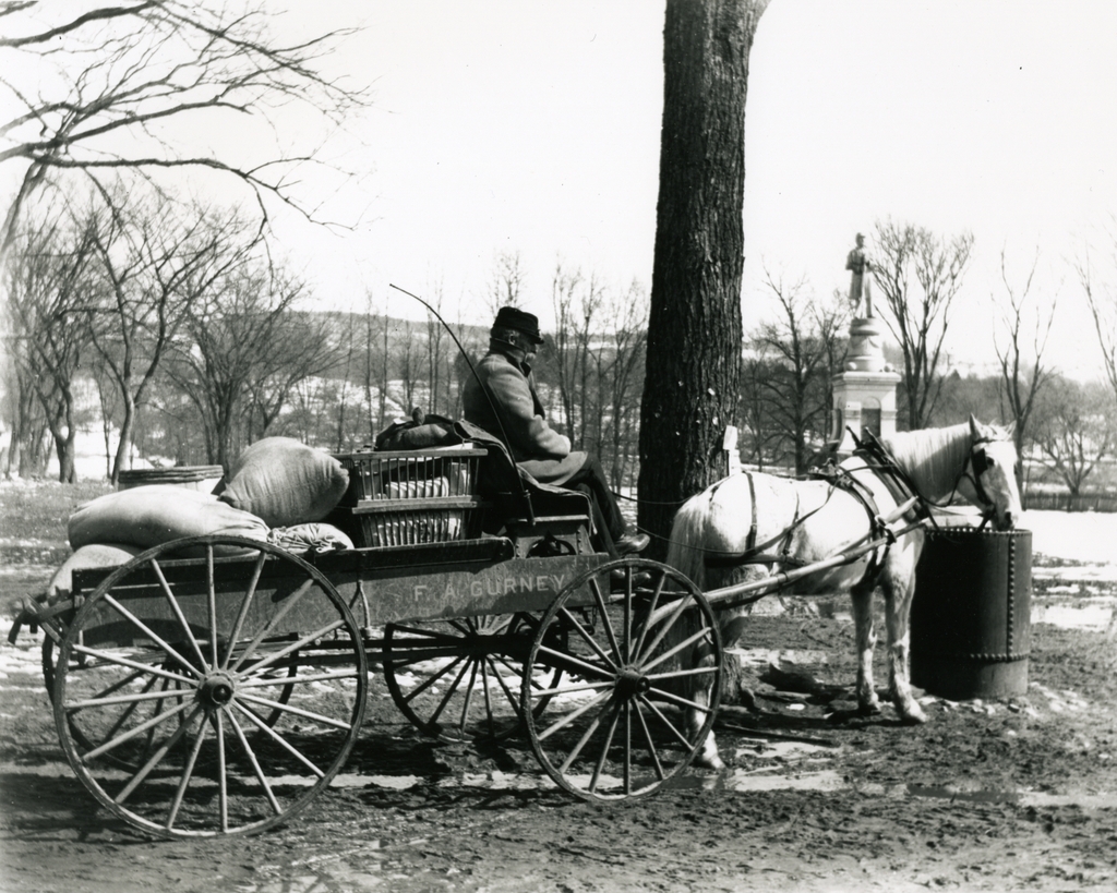
The delivery wagon for F.A. Gurney’s Store, seen on Main Street in Wilbraham around 1903. Photo courtesy of the Wilbraham Public Library.

455_1903c wpl

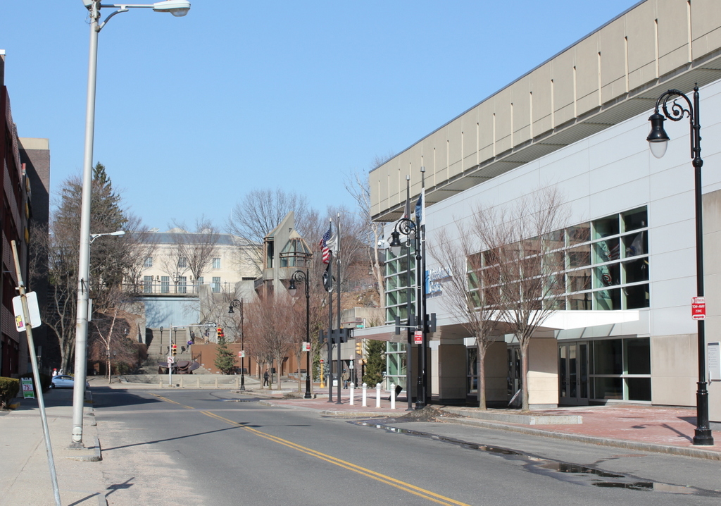
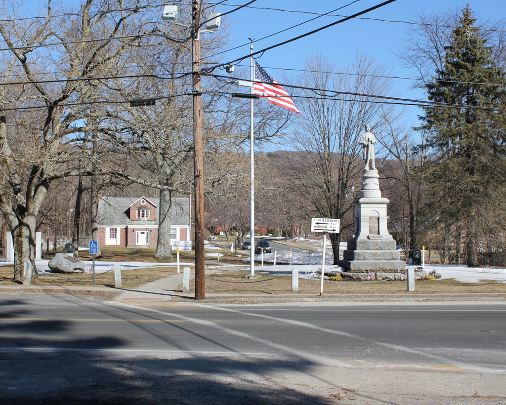
The same scene in 2015:

455_2015

The town of Wilbraham was originally part of Springfield, located on the far eastern end of Springfield’s original 1636 boundaries, where the relatively flat Connecticut River valley comes to an abrupt end at the hills seen in the distance.  When first settled in 1730, it was known as the “Outward Commons,” and even earlier a part of present-day Wilbraham was given the rather hyperbolic name of “World’s End,” which seems to give a rather dramatic idea of how remote this area was to Springfield’s Puritan settlers.

These two photos are taken in the town center, just across from Crane Park and the Soldiers’ Monument.  According to the information provided by the Wilbraham Public Library, the 1903 scene shows Frank Blodgett driving the delivery wagon for the F.A. Gurney Store, a general store that was located just behind the photographer.  The destination of his goods is Sixteen Acres, just across the city line into Springfield.  Today, Sixteen Acres is a suburban neighborhood in Springfield, but at the turn of the last century it was a rural farming community, and the photo appears to have been taken sometime in late winter as the snow was melting, so the goods on the wagon were probably headed for farmers who were preparing for the coming spring.

The only obvious landmark in both photos is the Soldiers’ Monument, which was dedicated in 1894.  One of the guests at the dedication was future Governor and Senator Winthrop M. Crane, whose grandmother Lucinda Brewer once lived in a house on this spot.  Lucinda Brewer married paper manufacturer Zenas Crane, the founder of Crane & Co. in Dalton, Massachusetts.  Winthrop himself was the company president, and in 1879 he obtained a contract to produce the paper for United States paper money.  The company has been producing paper for American currency ever since, and Wilbraham’s Crane Park is named for the family.