Museum of Fine Arts, Boston (1)

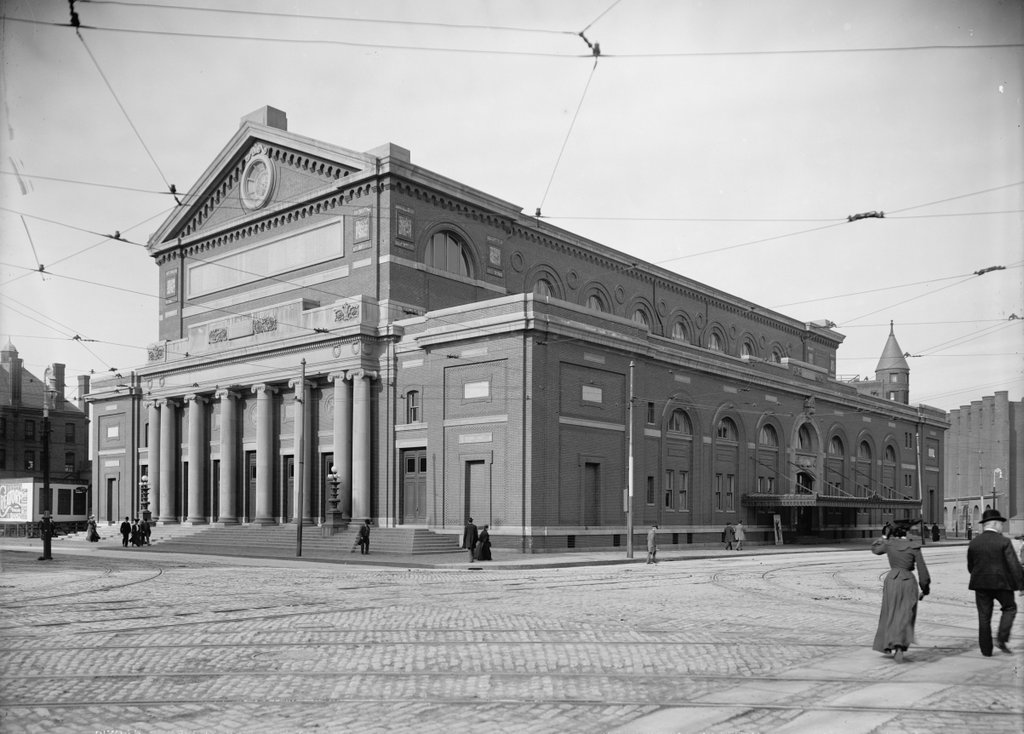
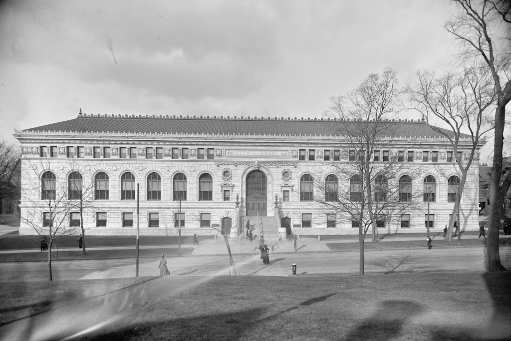
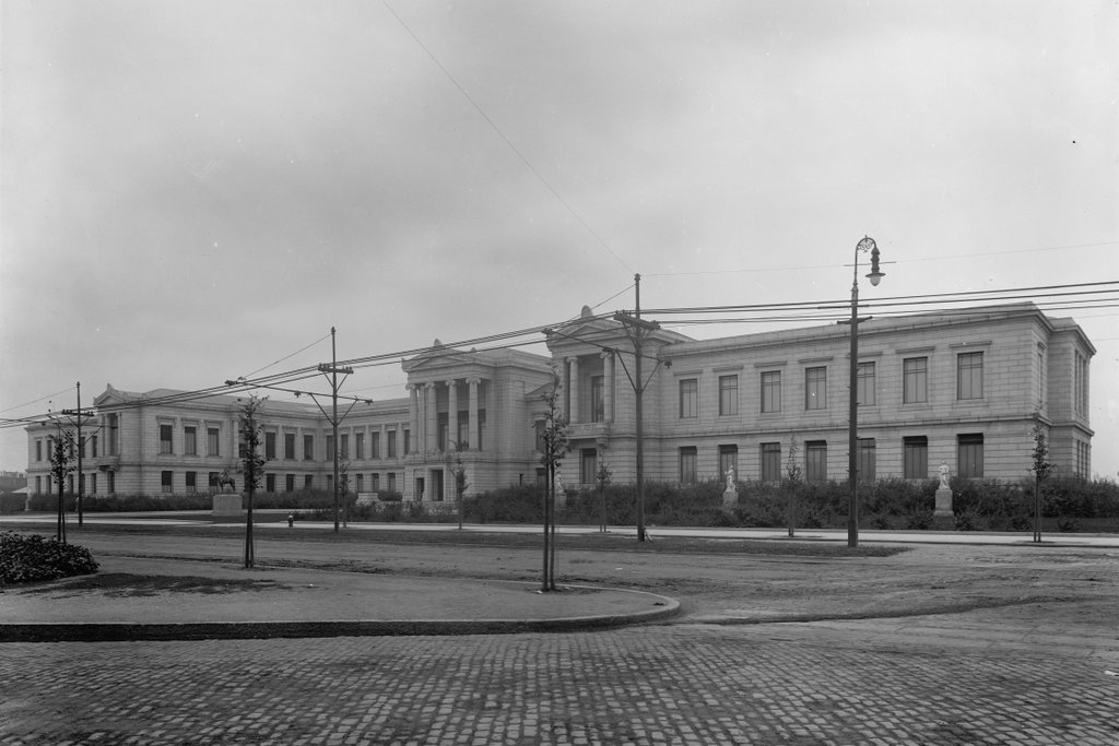
The Museum of Fine Arts on Huntington Street in Boston, around 1910-1920. Image courtesy of the Library of Congress, Detroit Publishing Company Collection.
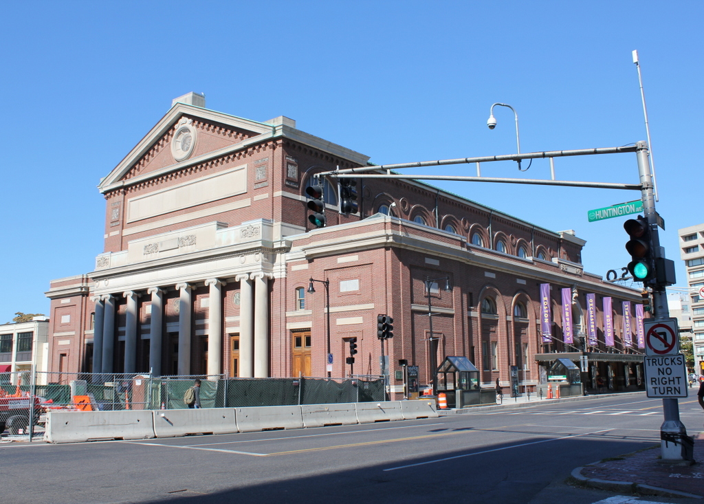
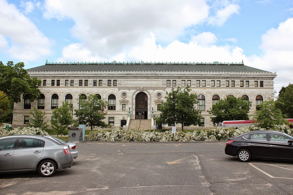
775_1910-1920 loc

The museum in 2015:

775_2015
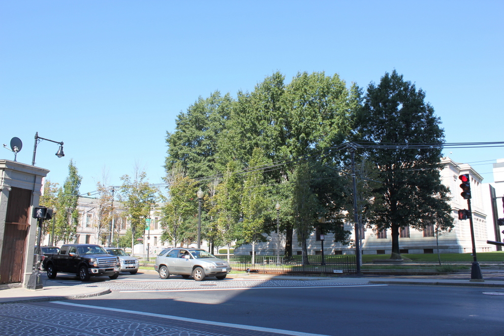
This view of the Museum of Fine Arts really hasn’t changed much in the past century, although it is hard to tell with all of the trees blocking the view in the second photo.  The Museum of Fine Arts had been established in 1870, and its first permanent home was opened at Copley Square in 1876.  The original building soon became too small for the museum’s growing collections, though, and in 1899 they purchased this plot of land on Huntington Avenue, a little over a mile west of Copley Square.

The new museum was designed by architect Guy Lowell, who deliberately designed it so that it could easily be expanded as the museum grew and as money became available.  Since then, it has grown substantially beyond its original 1909 footprint, and is now over 600,000 square feet in area.  One major addition was the West Wing, now the Linde Family Wing for Contemporary Art, which was designed by noted architect I.M. Pei in 1981, and the most recent was in 2010, when the new Art of the Americas wing was completed.  It is now one of the largest art museums in the United States, with an internationally-significant collection of nearly half a million works from around the world.  Much of their collection has also been digitized, and it can be viewed online through their website.  At least one of their works, an early photograph by J.J. Hawes, is featured in this blog post about Arlington Street Church.

Horticultural Hall, Boston

Horticultural Hall, at the corner of Huntington Avenue and Massachusetts Avenue in Boston, around 1901-1906. Image courtesy of the Library of Congress, Detroit Publishing Company Collection.

773_1900-1906 loc

The building in 2015:

773_2015
Horticultural Hall was built in 1901, around the same time as its neighbors, Symphony Hall to the left across Massachusetts Avenue, and Chickering Hall, visible to the right in the first photo.  Chickering Hall has long since been demolished as part of the development of the Christian Science Center in the 1960s, but both Horticultural Hall and Symphony Hall still stand here at the corner of Massachusetts and Huntington Avenues.

The Massachusetts Horticultural Society was founded in 1829 to promote modern practices in horticulture, and this building was the organization’s third facility.  It included a large exhibition hall for plant shows, with would have included the flower show that was advertised on the sign at the corner of the building in the first photo.  The building also had a smaller exhibition hall, a 300-seat lecture hall, a library, and offices.

In more than a century since the first photo was taken, most of the scene has changed.  The buildings in the background have all been demolished, the streetcar line on Huntington Avenue is now underground as the “E” Branch of the Green Line, and Massachusetts Avenue now passes over Huntington Avenue on a bridge in the foreground.  As for the building itself, the Horticultural Society sold the building to the neighboring Christian Science Church in 1992, but its exterior has seen very few changes, and along with the neighboring Symphony Hall it is listed on the National Register of Historic Places.

Symphony Hall, Boston

Symphony Hall, at the corner of Huntington Avenue and Massachusetts Avenue in Boston, around 1904. Image courtesy of the Library of Congress, Detroit Publishing Company Collection.

772_1904c loc

The building in 2015:

772_2015
Boston’s Symphony Hall is one of many prominent concert halls in this section of Boston, and it has been the home of the Boston Symphony Orchestra and the Boston Pops ever since it opened in 1900.  It was designed by McKim, Mead and White, the same architectural firm that built the Boston Public Library at Copley Square a few years earlier.  Like the library, it is an excellent example of Renaissance Revival architecture, but Symphony Hall is perhaps best known not for its visual appeal, but rather its acoustic properties.  Harvard professor and physicist Wallace Clement Sabine used his knowledge of acoustics to design the auditorium, making it the world’s first concert hall to be scientifically designed in such a way.  Because of this, it is still regarded as one of the best concert halls in the world.

Over the years, this section of the Back Bay has seen some dramatic changes, but Symphony Hall is essentially the same, both on the exterior and interior.  The Boston Symphony Orchestra and the Pops continue to perform here, along with the Handel and Hadyn Society.  With a seating capacity of over 2,000, it has also been used for a number of other civil purposes, ranging from political rallies and inaugurations to business conventions and fashion shows.  In addition, many renowned authors have given lectures here; the building’s National Register of Historic Places registration form identifies many visiting writers from the early 20th century, including Edward Everett Hale, Julia Ward Howe, Booker T. Washington, G.K. Chesterton, Robert Frost, and Sir Arthur Conan Doyle.

South Station, Boston

South Station around the time that it opened in 1899. Image courtesy of the Library of Congress, Detroit Publishing Company Collection.

263_1899c-loc

The same view around 1905, after the construction of the Atlantic Avenue Elevated. Image courtesy of the Library of Congress, Detroit Publishing Company Collection.

Transportation

South Station in 2014:

These three photos reveal the changes that have taken place here at South Station over the past 115 years.  While the building itself (or at least most of it) has remained essentially the same, its surroundings have continually changed.

Before 1899, four different railroads had terminals in the general vicinity of the present-day station.  To make things simpler, South Station was built, and all four lines were rerouted to it.  A few years later, in 1901, the Atlantic Avenue Elevated was built, as seen in the second photo.  The rapid transit line included a station at South Station, which can be seen on the far right of the 1905 photo.

The third photo shows the result of changes in the way people travel; the Atlantic Avenue Elevated closed in 1938, and was demolished four years later.  Even South Station was seeing a severe drop in passengers in postwar America, as cars became the primary method of travel.  However, Boston’s colonial-era street network was not particularly accommodating to large number of cars, so the Central Artery was built in the 1950s.  Most of the Central Artery was elevated, but it was put underground for a few blocks near South Station, and was known as the Dewey Square Tunnel.

The Dewey Square Tunnel turned out to be a foreshadowing of things to come; part of Boston’s infamous Big Dig involved putting the entire Central Artery underground.  Today, the tunnel is still there, directly underneath where I was standing when I took the photo.  It is the only existing part of the Central Artery; the remainder of the 1950s-era expressway was demolished upon completion of the Big Dig.

Today, South Station has been trimmed a bit – notice that the facade on both sides is shorter than in the first two photos.  This was a result of demolition in the 1960s, at a time when many railroads were cutting back or eliminating passenger service.  However, today South Station is a busy transportation center again – it is the busiest railroad station in New England and the sixth busiest in the country, and it is the northern terminus of the Northeast Corridor, the busiest rail line in the country.

Springfield Public Library, Springfield Mass (3)

The newly-completed Springfield Public Library, around 1912. Image courtesy of the Library of Congress, Detroit Publishing Company Collection.

219_1912c-loc.tif

The building in 2014:

219_2014

Springfield’s current main branch of the public library system was opened on January 10, 1912, which is probably around the time that the first photo was taken. The Library of Congress data indicates that it was taken between 1900 and 1910, but obviously that is not the case. Regardless, not much has changed with this view, although the foreground is now a parking lot; in 1912, it was the front lawn of the Church of the Unity.

Court Square, Springfield (1)

Here’s an interesting photo of Court Square, taken in 1909. Image courtesy of the Library of Congress, Panoramic Photographs Collection.

005_1909-2Bloc

From the same angle, taken in 2012:

005_2012

Notice the difference? Because there isn’t a whole lot that has changed along the south and west sides of Court Square in the past century.  In fact, other than cosmetic changes to some of the fountains and such in Court Square, the only real difference is the added wing of the old Hampden County Courthouse, which is visible in the 2012 photo just behind and to the left of the church.  In the 1909 photo, if you look close, you can see the construction for the wing, but at this point when the photo had been taken, it had not yet been completed.

The prominent building in the center of both photos is the former Court Square Hotel.  Built in 1892, it was added on to in 1900, with the sixth floor being added, along with the right-hand part of the building (the front facade used to be symmetrical until the addition).  Just to the left of it is a small brick building, barely visible behind the gazebo in the 2012 photo.  This building, known as Byers Block, was built in 1835 and is the only surviving one of a number of identical buildings that used to run along Elm Street in the mid 19th century.  The oldest building in both photos, however, is Old First Church.  Built in 1819, it was nearly 100 when the old photo was taken, and externally still looks essentially the same today.