Rhode Island State House, Providence, RI

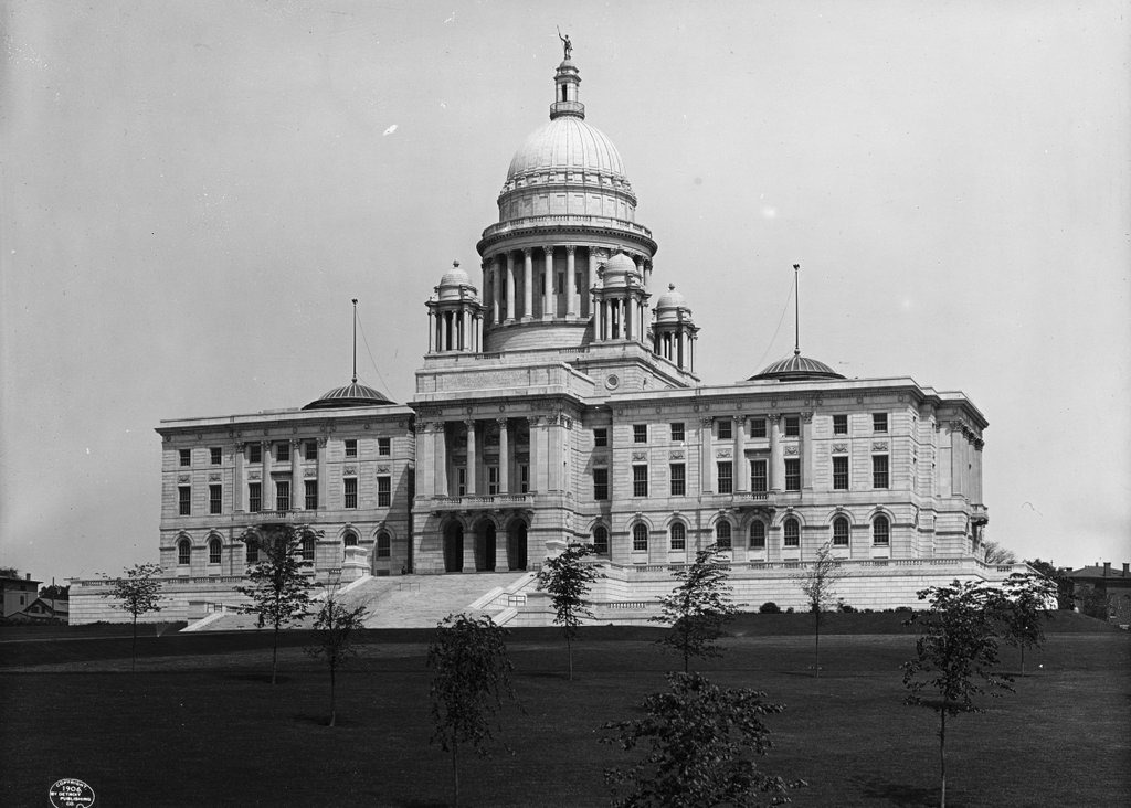
The south side of the Rhode Island State House in Providence, around 1906. Image courtesy of the Library of Congress, Detroit Publishing Company Collection.
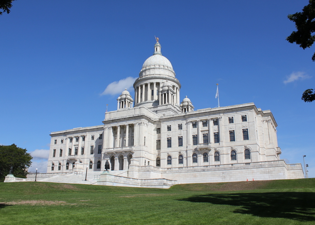
1058_1906c-loc

The scene in 2016:

1058_2016
Rhode Island is known for having the smallest land area of any US state, but despite its diminutive size, it had an unusual state capital arrangement for many years, with the legislature alternating sessions between the five county courthouses, effectively giving the state five capital cities. While much larger states managed to make do with just one capital city, this practice continued until 1854, when the rotation was reduced to just two, Providence and Newport. Having joint capitals was not unique to Rhode Island – neighboring Connecticut did the same for many years – but Rhode Island continued the practice until 1900.

At this point, when the legislature was in Providence, they were still meeting in the small colonial-era courthouse on Benefit Street. It hardly compared to the far grander capitol buildings other New England states such as Connecticut and Massachusetts, so in 1895 construction began on the present-day Rhode Island State House. It was built on Smith Hill, a hill that overlooks downtown Providence on the other side of the Woonasquatucket River. Its architecture resembles the US Capitol Building, with wings on either side for the two legislative houses and a large rotunda in the center, and it was designed by the prominent firm of McKim, Mead and White in their distinctive Classical Revival style.

The Rhode Island legislature began meeting in the new building in 1901, although it was not completed until 1904, after nearly a decade of construction. Today, the area around the State House has seen some dramatic changes. Interstate 95 now passes just west of here, and just to the east is the Northeast Corridor, the busiest passenger rail line in the country. To the southwest is Providence Place, a large shopping mall with adjacent parking garages. However, here on the State House grounds, very little has changed. The grounds retain a park-like atmosphere, and the historic building itself is still the seat of Rhode Island’s state government.

Harris Block, Springfield, Mass

The Harris Block, at 454-472 Bridge Street in Springfield, around 1938-1939. Image courtesy of the Springfield Preservation Trust.

1040_1938-1939-spt

The building in 2016:

1040_2016
As mentioned in previous posts, Chestnut Street transitioned from a residential to commercial neighborhood in the early 1920s. The home of Daniel Harris once stood just to the right of here, but in 1923 it was dismantled and moved to Westerly, Rhode Island. His name lived on, though, with the Harris Block. This two-story commercial building was built in 1925 at the corner of Chestnut and Bridge Streets, and formed part of the northern side of the newly-developed Apremont Triangle.

When Bridge Street was extended east of Chestnut Street in the early 1920s, it crossed Daniel Harris’s old lot and connected with Pearl Street. This formed a roughly isosceles triangle between the three streets, with a small park in the center that was named in honor of the 104th Infantry, a Springfield-based unit that fought at Apremont during World War I.

Three of the buildings fronting the triangle, including the Harris Block, were designed by architect Samuel M. Green. All three had similar designs, and were two stories tall, with large storefront space on the first floor. This made them ideal for car dealerships, and the Apremont Triangle soon became the center of the city’s automobile industry. Here in the Harris Block, the corner storefront was originally a Rolls-Royce showroom, and their Springfield branch offices were also located in the building.

By the time the first photo was taken, Rolls-Royce was no longer in the building, and the corner storefront was instead a pharmacy. Over the years, car dealerships have moved to more spacious lots outside of downtown, but all of the early 20th century buildings at the Apremont Triangle are still standing, including the Harris Block. Because of this, all of these buildings were added to the Apremont Triangle Historic District on the National Register of Historic Places.

Willys-Overland Block, Springfield, Mass

The Willys-Overland Block at the corner of Chestnut and Winter Streets in Springfield, around 1938-1939. Image courtesy of the Springfield Preservation Trust.

1039_1938-1939-spt

The building in 2016:

1039_2016
As mentioned in the previous post, Chestnut Street was once home to some of Springfield’s wealthiest residents. However, by the early 1900s the city’s commercial center was growing east from Main Street, and this area around the corners of Chestnut, Bridge, and Pearl Streets became the center of the city’s automotive business. Springfield played a pioneering role in early automobile manufacturing, starting with Charles and Frank Duryea. In the 1890s, they developed the country’s first gasoline-powered car here in Springfield, just a few blocks away on Taylor Street. In the years that followed, other automobile companies came to the city, drawn by its manufacturing tradition and large pool of skilled workers.

In the first few decades of the 20th century, Springfield was home to many car manufacturers. The Knox Automobile Company was headquartered in the city, and other companies had branches, including Rolls-Royce and Willys-Overland. Unlike Rolls-Royce, the Toledo-based Willys-Overland no longer exists, but its legacy in Springfield lives on in this building, which they built in 1916. The first floor housed their showroom, and the rest of the building had a service station along with a thousand-car garage.

The company remained here for just five years, but the building continued to be used for automotive-related purposes. In the first photo, the upper floors were the Kimball Garage, serving the Hotel Kimball, which is located diagonally across Chestnut Street from here. However, it has since been neglected for many years. It was damaged in a November 2012 natural gas explosion that leveled an adjacent building and shattered most of the windows in the Willys-Overland Block. Although listed on the National Register of Historic Places, the building’s future is uncertain, and in 2015 the City Council established it as a one-building historic district, in an effort to protect it from possible demolition.

Main and Front Streets, Worcester, Mass

Looking north on Main Street from the corner of Front Street, around 1895. Image from Picturesque Worcester (1895).

1028_1895c-picturesqueworcester

Main Street in 2016:

1028_2016
This intersection is right in the middle of Worcester’s commercial center, and most of the buildings in the first photo are gone today. Some would be gone within a decade or so, including the ones that stood on the west side of Main Street between Pearl and Walnut Streets. These were replaced with the 1907 Slater Building in the middle of the photo, and the 1897 State Mutual Building further in the distance.

Despite these changes, though, the buildings in the immediate foreground have survived to the present day. On the left, at the corner of Pleasant Street, is the Rogers Building. Completed in 1869, it was designed in the Second Empire style that was popular in the United States in the post Civil War years. Its original design was partially altered in the 20th century, though. The mansard roof on the left side still survives, but on right side of the building it was removed and replaced with a fifth story.

Another survivor from the first photo, just beyond the Rogers Building, is the smaller Taylor-Kelly Building, which dates back to around 1878. On the other side of the street, at the corner of Front Street, is Harrington Corner. This commercial block was built in 1850, and for over 160 years the Italianate building has been a distinctive feature in downtown Worcester. Today, it is still standing as the oldest building left from the 1895 photo here.

Worcester Common, Worcester, Mass (2)

Another view of the Worcester Common, taken looking west from the corner of Church and Front Streets, around 1906. Image courtesy of the Library of Congress, Detroit Publishing Company Collection.

1024_1906c-loc

The Common in 2016:

1024_2016
Taken from the northeast corner of the Common, on the other end of Church Street from an earlier post, this view shows the Soldiers’ Monument in the center, with City Hall to the left and Front Street to the right. The monument is the oldest feature in the first photo; it was dedicated in 1874 in honor of Worcester’s fallen soldiers and sailors of the Civil War, and was designed by prominent sculptor Randolph Rogers.

Along with the monument, several other buildings remain from the first photo, including the 1898 City Hall. On the far right, partially hidden by trees, are two 19th century commercial buildings. Both were designed by Fuller & Delano, a Worcester-based firm that was responsible for many other significant buildings in the city. The tall red brick building is the Chase Building, which was built in 1886 and, although the top floors were later altered, it is still standing. To the right of it, at the corner of Commercial Street, is the Ransom C. Taylor Block, built around 1897.

Today, the only particularly obvious change to this scene is the Worcester Plaza building in the distance. Originally built as the Worcester County National Bank Tower, it was completed in 1974, and is tied for the record of the tallest building in the city.

Bancroft Hotel, Worcester, Mass

The Bancroft Hotel, at the corner of Franklin and Portland Streets in Worcester, around 1912-1920. Image courtesy of the Library of Congress, Detroit Publishing Company Collection.

1023_1910-1920-loc

The building in 2016:

1023_2016
The Bancroft Hotel opened in 1913 as the city’s grandest hotel, at a time when Worcester was a prosperous industrial city. Originally planned as a 225-room hotel, the 9-story building was expanded to 320 by the time it was completed. It was designed by the Buffalo-based architectural firm of Esenwein & Johnson, and reflects the Classical Revival style that was often seen in early 20th century grand hotels.

In 1926, the building was expanded in the back along Portland Street, which is visible in the distance of the present photo. This brought the hotel up to 500 rooms, and remained as Worcester’s premier hotel well into the middle of the century. However, as was the case in cities across the northeast by the 1960s, the population was in decline, and interstate highways shifted travelers away from downtown Worcester. In 1964, the hotel closed, but the historic building was preserved, and renovated into apartments. Today, it has 255 housing units, and it is listed on the National Register of Historic Places.