Civil War Monument, Holyoke Mass

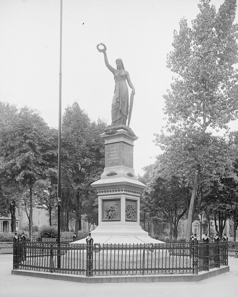
The Civil War Monument in Veterans’ Memorial Park in Holyoke, around 1900-1910. Image courtesy of the Library of Congress, Detroit Publishing Company Collection.

495_1900-1910 loc

The statue in 2015:

495_2015

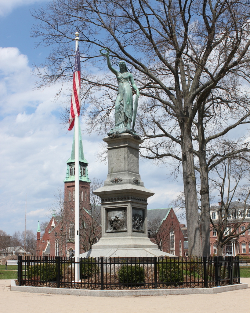
Civil War monuments are a common feature in communities across the country, and Holyoke is no exception with their monument to the city’s 55 residents who died in the war.  What is rather unusual about this one, though, is the sculptor: former Confederate soldier Henry Jackson Ellicott.  It is also unusual in that most Civil War monuments feature the figure of a soldier, while Ellicott’s creation has Liberty holding a wreath atop the monument.  It was dedicated on America’s centennial, July 4, 1876, and today it remains at the center of Veterans Park, which now includes monuments for veterans of World War II, Korea, and Vietnam.

Not much of the surrounding neighborhood is visible in the first photo, but St. Jerome’s Church is clearly visible in the 2015 view.  Although mostly obscured by leaves, the church is there in the first photo; in fact, not only is it older than the monument, but it is older than the war itself.  The church was completed in 1860 to serve the growing population of mill workers, and was the first of many Catholic churches in Holyoke.  The statue includes a list of the 55 Holyoke men killed in the war, and among these are Irish names like Sullivan, McDonald, Cronan, and Donahue, so they very well could have been parishioners across the street at St. Jerome’s Church before they enlisted.

Venezian Monumental Works, Springfield Mass

The Venezian Monumental Works building on State Street in Springfield, around 1938-1939. Photo courtesy of the Springfield Preservation Trust.

485_1938-1939 spt

The building in 2015:

485_2015

This building is located right next to the architecturally similar building at 1579 State Street, which was probably photographed on the same day as this one.  However, while the former Frank’s Service building has long been shuttered, the Venezian Monumental Works is still in business.  The company is actually substantially older than even the first photo; it was established in 1882, when the Pine Point neighborhood was on the remote outskirts of the city.  Since then, the neighborhood has grown, which has presumably increased demand for headstones, and it also doesn’t hurt that they are located right next to St. Michael’s Cemetery.  Today, the building has doubled in size, but the original section is still visible on the left side.

Springfield Armory Entrance, Springfield Mass

The entrance to the Springfield Armory at the corner of State Street and Byers Street, around 1907. Photo courtesy of the Library of Congress, Detroit Publishing Company Collection.

482_1907c loc.tif

The entrance in 2015:

482_2015

This gate at the southwestern corner of the Armory grounds was opened in the 1870s, when the grade of State Street was lowered and the previous main entrance became unusable.  This became the main entrance for many years, but the advent of automobiles and trucks made the narrow gate and fairly steep grade impractical.  So, around 10 years after the first photo was taken, a new main entrance was opened on Federal Street; this continues to function as the main entrance for Springfield Technical Community College, which now uses the Armory grounds.  In the distance of both photos is the Arsenal, which was completed in 1851 and is discussed further in this post.

Bodurtha Saw Mill, East Longmeadow Mass

The Bodurtha Saw Mill, seen from Westwood Avenue in East Longmeadow in 1887. Photo courtesy of the East Longmeadow Historical Commission.

477_1887 elonghistcom

The location in 2015:

477_2015

The town of East Longmeadow was never much of an industrial center, in part because it lacked major rivers to power factories.  The Pecousic Brook, seen here, is the only stream of any significance near the town center, and while it wasn’t suitable for large-scale industry, it did power several small mills, including the Bodurtha Saw Mill.  The mill was built in 1820 as a grist mill, where local farmers had corn, wheat, and oats ground into flour.  Later on, it was used as a sawmill, with several owners including Henry Bodurtha, for whom it is named.  It burned in 1906, and today there doesn’t seem to be any evidence of either the mill or the reservoir that was once here.

Glendale Road, Wilbraham Mass

Looking north on Glendale Road in Wilbraham, toward the intersection of Monson Road, around 1914. Photo courtesy of the Wilbraham Public Library.

466_1914c wpl

Glendale Road in 2015:

466_2015

Topographically speaking, the town of Wilbraham is divided into two major sections: the western half of the town is part of the Connecticut River valley, and is mostly flat.  This was the area that was first settled in Wilbraham, as it provided decent farmland and a close proximity to Springfield.  However, the eastern part of the town is very different.  Just east of Main Street, the terrain abruptly rises, with a ridgeline over 500 feet above the center of town.  The land on the other side of this ridge is very different; it tends to be steeper, more rocky, and less arable than the valley, so this area was slow to develop.

It is this eastern section of town that is seen in these two views, an area known as Glendale.  When the 1914 photo was taken, it had a church, a cemetery, a school (out of view beyond the church), and a few farmhouses.  It was never really a village, just a crossroads.  The first photo was taken at a time when automobiles were beginning to become more common, but it’s unlikely that too many would’ve ventured out into this area, given the condition of the roads.  The ruts in the foreground indicate that the road probably got fairly muddy, and based on looking at the slope, it appears that this section of road would probably get washed out fairly easily in a rainstorm.

The only building in this scene is the Glendale Methodist Church, which was built in 1868 to serve the farmers in the eastern part of town, who would’ve otherwise had to venture up and down steep grades to reach the Methodist church in the town center.  Across Glendale Road from the church, on the left-hand side of the photo, is Glendale Cemetery, which is actually substantially older than the church itself; the earliest gravestone dates to 1787.  Today, the church building is still there, barely visible beyond the trees, but the congregation itself disbanded in 2006, and the building has been vacant ever since.  Glendale and Monson Roads are still there, although the grade of the intersection has been raised substantially by filling in some of the swampy area along the stream that passes under the roads.

Soldiers’ Monument, Wilbraham Mass

The Soldiers’ Monument in Wilbraham, on Main Street opposite Springfield Street, in an undated photograph probably taken in the early 20th century.  Photo courtesy of the Wilbraham Public Library.

463 1900sc wpl

The monument in 2015:

463_2015

As mentioned in this post, the Soldiers’ Monument in Wilbraham was dedicated in 1894, in honor of the 228 men from Wilbraham who served in the Civil War.  According to the inscription on the monument, it is dedicated “To the men of Wilbraham who served their country in the war which preserved the Union and destroyed slavery.  This monument is erected to perpetuate the memory of their patriotic service.”  According to the records in the town clerk’s office, 29 Wilbraham men died in the war.  However, of those 29, only six were killed on the battlefield, a statistic that is not at all unusual for the Civil War, given that around two thirds of all deaths were a result of disease rather than battle.  One particularly notable Wilbraham veteran was Watson W. Bridge, who was the captain of Company F in the 54th Massachusetts Infantry Regiment, an African-American unit that was depicted in the 1989 film Glory.

The monument was built on the site of the birthplace of Lucinda Brewer, the wife of paper manufacturer Zenas Crane, founder of Crane & Co. in Dalton, Massachusetts.  Their grandson, Winthrop M. Crane, attended the dedication ceremony in 1894.  Several decades earlier, he had secured a contract to produce the paper for US currency, something that the company continues to do today.  He would later go on to serve as Governor from 1900 to 1903, and represented Massachusetts in the US Senate from 1904 to 1913.

In the years since the first photo was taken, the land behind the monument has been developed, as seen in the 2015 view.  To the left is the former Wilbraham Post Office building, and directly behind the monument is the Wilbraham Public Library.  To the right, just outside of the view of the photo, is a commercial development.