George Bancroft House, Springfield, Mass

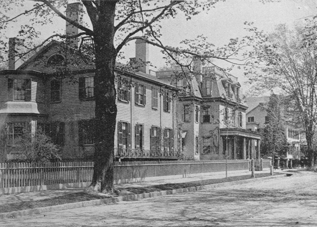
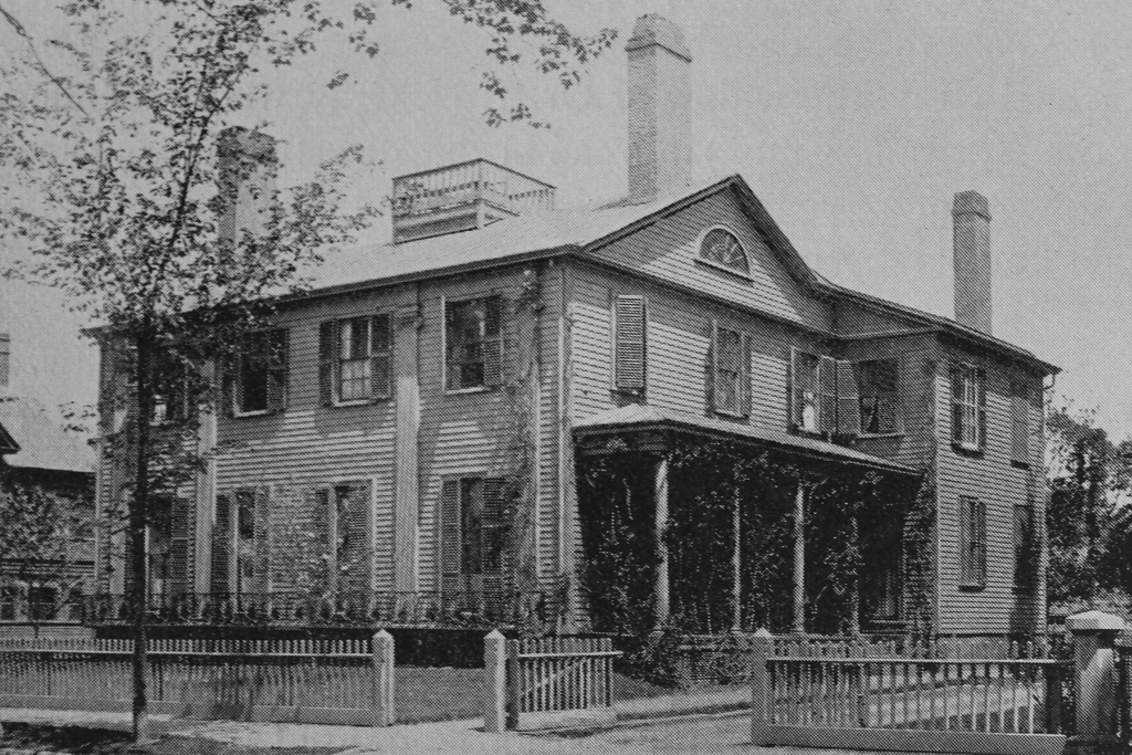
The George Bancroft House at 49 Chestnut Street in Springfield, around 1893. Image from Sketches of the old inhabitants and other citizens of old Springfield (1893).
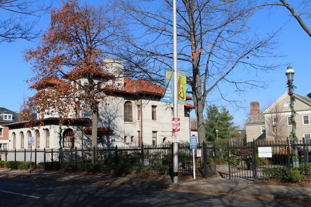
844_1893c sketchesinhabitants

The scene in 2015:

844_2015
The house in the first photo was built in 1836 by Jonathan Dwight, Jr., a prominent businessman and local politician. It was a gift to his daughter Sarah and her husband George Bancroft, who had moved from Northampton to Springfield a year earlier. However, Sarah died only a few months later at the age of 34, and in 1838 Bancroft left Springfield after being appointed Collector of Customs for the Port of Boston. He never returned to Springfield, but he went on to have a successful political career, serving as the Secretary of the Navy from 1845 to 1846 and as the Ambassador to the United Kingdom from 1846 to 1849. In addition, he was a noted historian who published an extensive 12-volume history of the United States, which was written over a 30-year period from 1834 to 1874.

After Bancroft left this house, it was sold to his brother-in-law, Jonathan Dwight III, who lived here until he moved to Newport, Rhode Island in 1850. He, in turn, sold it to another brother-in-law of his, George Bliss, who then gave it as a gift to his daughter Sarah and her husband George Walker. Like the previous George who lived in this house, George Walker was also a nationally significant figure. He served a number of diverse roles; aside from his law practice and several terms in the state legislature, he was also influential in the banking industry. From 1860 to 1864 he served as the Massachusetts Banking Commissioner, and later on he was the founder and president of the Third National Bank of Springfield. He also served as the vice president of Western Union and as the vice president of the Gold and Stock Telegraph Company, and from 1880 to 1887 he added diplomacy to his resume, serving as the US Consul-General in Paris.

The third prominent owner of this house was William H. Haile, a politician who served as the city’s mayor in 1881, a state senator in 1882 and 1883, the Lieutenant Governor of Massachusetts from 1890 to 1892, and he was the unsuccessful Republican candidate for Governor in 1892. He had previously lived in a townhouse on nearby Mattoon Street, but he was living here on Chestnut Street by the early 1880s, and he remained here until his death in 1901.

The first photo was taken during Haile’s ownership, and it shows some of the alterations that had been made to the house over the years. It was originally built in the typical Greek Revival style that was common in Springfield during the 1830s, with two stories and a front gable roof. By the time the first photo was taken, though, the old roof had been replaced by a mansard roof and a third story, reflecting the Second Empire style that was popular in the 1860s and 1870s. In 1902, the house was purchased by George Walter Vincent Smith, the prominent art collector whose collection formed the basis of the art museum that now bears his name. He died in 1923, and at some point soon after his wife’s death in 1928, the house was demolished. It was replaced by a second art museum, the Art Deco style D’Amour Museum of Fine Arts, which now stands on the site of the old house.

Armory Grounds, Springfield, Mass

Looking north on the Armory grounds from near the center of the Green, around 1910-1920. Image courtesy of the Library of Congress, Detroit Publishing Company Collection.

843_1910-1920c loc

The scene in 2015:

843_2015
This view shows part of the same scene as the photos in the previous post, with part of Officers’ Row visible along the north side of the Green. As mentioned there, these houses were demolished in the 1970s to build the current academic buildings for Springfield Technical Community College after the Armory closed. However, several other buildings from the first photo are still standing today, including the Long Storehouse in the distance, which was built in stages between 1846 and 1863. In front of it are several brick Greek Revival style houses that were built in the 1830s as officers’ quarters. Today, these houses are used by several different campus departments, although only the one in the distance near the center of the photo is visible from this angle; the rest are hidden behind the modern campus buildings.

Officers’ Row at the Armory, Springfield, Mass

Facing east on the Armory grounds along Officers’ Row, around 1910-1920. Image courtesy of the Library of Congress, Detroit Publishing Company Collection.

842_1910-1920c loc

The scene in 2015:

842_2015
The Springfield Armory closed in 1968, and most of the grounds are now the home of Springfield Technical Community College, but most of the property has been well preserved as part of the Springfield Armory National Historic Site. However, this area is the exception, as it has undergone significant changes since becoming a college campus. Located along the north side of the Green, these homes for officers were built between the 1830s and the 1890s, but they were demolished in the 1970s to make room for new academic buildings at the college. In the foreground of the 2015 view is Scibelli Hall (1988), with Deliso Hall (1973) and Putnam Hall (1974) in the distance. The only readily visible building from the first photo that still stands today is the former Administrative Building, now named Garvey Hall. This long building on the east end of the Green was built in 1862, and it now functions as the college’s administrative offices.

View from the Arsenal Tower, Springfield, Mass (5)

Another view looking north from the top of the Arsenal at the Springfield Armory, around 1900-1910. Image courtesy of the Library of Congress, Detroit Publishing Company Collection.

841_1900-1910c loc

The view in 2015, photographed with permission from the Springfield Armory National Historic Site.

841_2015
This scene shows the view looking just a little further to the right than this earlier post, and it shows how both the Springfield Armory and the Liberty Heights neighborhood in the distance has changed over the past century. Aside from the Armory’s Long Storehouse in the foreground, the first photo shows sporadic development throughout the area, with the most noticeable buildings being the factories on the left side. The factories were located along Warwick Street, with the Cheney Bigelow Wire Works on the far left, and the Taber Prang Art Company closer to the center. Beyond them, scattered houses illustrate the early stages of development in the Liberty Heights area, with Mount Tom as a backdrop in the distance.

In the 2015 view, the most obvious change is the building in the foreground. The Springfield Armory closed in 1968, and the grounds became home to Springfield Technical Community College. Most of the former Armory buildings were converted into classroom and office space for the college, but there were also a few new buildings that were constructed for the school, including Scibelli Hall, as seen here. Not much is visible in the distance in the 2015 view, but most of the old factories on Warwick Street from the first photo are still standing. One prominent Liberty Heights landmark that was built after the first photo was taken is the Our Lady of Hope Church, which was built in 1925 and can be seen in the distance just to the left of Scibelli Hall.

For other then and now views from the Arsenal tower, see the earlier posts showing the view facing southwest, west, northwest, and south.

View from the Arsenal Tower, Springfield, Mass (4)

The view looking south from the top of the Arsenal tower at the Springfield Armory, around 1882. Image from Springfield Illustrated (1882).

840_1882c spfldillustrated

The view in 2015:

840_2015
This scene in Springfield shows State Street in the foreground, with the South End in the distance. When the first photo was taken, this area on the slope of the hill consisted mainly of single-family homes for upper middle class professionals, who lived on streets like Union, Temple, High, and the lower part of Maple Street. The upper part of Maple Street, barely visible on the far left, was home to many of the city’s wealthiest citizens, and some of these Gilded Age mansions are still standing there today. Further in the distance, the South End was largely a working-class neighborhood, with a number of Italian immigrants moving into the area starting around the time that the first photo was taken.

Over 130 years later, much has changed in this view. As the population grew in the early 20th century, many of the single-family homes along the streets in the foreground were replaced with apartment blocks, as was the State Street Methodist Episcopal Church on the left side of the photo. Located at the corner of State and Myrtle Streets, it was demolished by 1901 to build the large apartment building that still stands there. Today, the only prominent landmark that is visible in both photos is the South Congregational Church, which was built in 1875 at the corner of Maple and High Streets. Another nearby building that opened around the same time was the old high school, which later became a grammar school when Classical High School was built next to it in 1898. The old high school, visible on the extreme right of the first photo, was demolished when Classical expanded in 1922, and Classical High School itself closed in 1986, but the yellow brick building on the far right is still standing after having been converted into condominiums.

For other then and now views from the Arsenal tower, see the other posts showing the view facing southwest, west, northwest, and north.

View from the Arsenal Tower, Springfield, Mass (3)

Looking north from the Arsenal tower at the Springfield Armory, around 1882. Image from Springfield Illustrated (1882).

839_1882c spfldillustrated

The view in 2015, photographed with permission from the Springfield Armory National Historic Site.

839_2015
This view from the top of the Main Arsenal tower shows the northwest corner of the Springfield Armory and the Liberty Heights neighborhood in the distance. Both areas have undergone some significant changes, with the most obvious being the large building to the right. Built for Springfield Technical Community College after the Armory closed in 1968, it occupies the ground where several officers’ houses once stood, as seen in the first photo. However, two other historic buildings in this scene survive today. The Long Storehouse, built between 1846 and 1863, is now partially hidden by newer construction, but it still stands along the northern edge of the campus. Just in front of it, in the center of the photo, is the much smaller Master Armorer’s House, a Greek Revival style home that was originally located next to the Main Arsenal before being moved to its current site shortly before the first photo was taken.

It is somewhat hard to tell, but the Liberty Heights neighborhood in the distance has undergone far more drastic changes than the Armory grounds. When the first photo was taken, this area to the northeast of downtown was sparsely populated, with large estates that were owned by wealthy citizens. However, as the city grew, these properties were subdivided and developed with multi-family homes by the early 1900s. The neighborhood changed even further in the late 1960s and early 1970s, when Interstate 291 was built through the area, but today at least one of the historic mid-19th century homes has survived. Built in 1853, the Joshua Bliss Vinton House is barely visible on the extreme left of the 1882 photo, and it is still standing at the end of Underwood Street, where it serves as the rectory for Our Lady of the Rosary Church on Franklin Street. Both the church and the house are mostly hidden by trees in the 2015 scene, but the steeple of the church can be seen on the far left, and just beyond it is the cupola of the house.

For other then and now views from the Arsenal tower, see the other posts showing the view facing southwest, west, south, and north.