Scollay Square, Boston

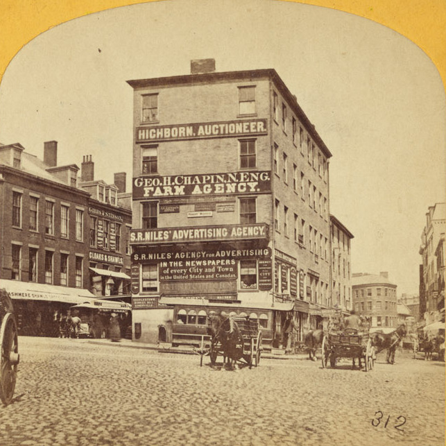
Scollay Square, looking north from the corner of Tremont and Court Streets, sometime in the 1860s. Image courtesy of the Boston Public Library.
823_1860-1869c bpl

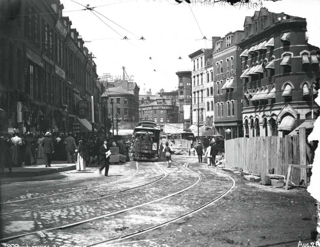
Scollay Square on August 26, 1897. Image courtesy of the City of Boston Archives.
823_1897_08_26 coba

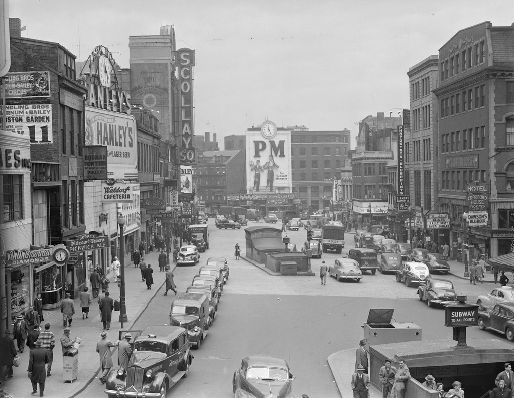
Scollay Square around 1942. Image courtesy of the Boston Public Library, Leslie Jones Collection.
823_1942c bpl

The scene in 2015:

823_2015
These four photos reveal the dramatic transformations that have occurred at Boston’s Scollay Square over the past 150 years. The square once included a long, narrow row of buildings in the middle, which appear on city maps as early as the 1720s. The construction date for the building in the first photo is unknown, but it was once at the southern end of this row, and in 1795 it was purchased by William Scollay, a real estate developer for whom the square would eventually be named. By the time the first photo was taken, all of the other buildings in the middle of the square had been demolished, and Scollay’s building was taken down soon after, around 1870.

The second photo shows a very different scene. Some of the buildings along the square are still standing, but the Scollay Building is gone, as are the horse-drawn trolleys from the first photo. Instead, they have been replaced by electric trolleys, like the one shown in the photo. However, these would not last long, at least not on the surface. The second photo was taken only about a week before the Tremont Street Subway opened, and the photo shows some of the construction activity as the workers prepared the Scollay Square station for its opening day on September 3. The station itself is not visible, but its ornate entrance can be seen in this post, which shows the scene from a slightly different angle.

Scollay Square had long been a major commercial center in the city, but by the time the third photo was taken in the 1940s, it had seen a dramatic decline. Many of the old buildings were still standing, but the businesses had become seedier. The 1942 photo shows a number of bars, liquor stores, cheap restaurants, and burlesque theaters, and the area was particularly popular among sailors on leave from the Boston Navy Yard and college students from the many nearby schools. One prominent hotel and theater in both the second and third photos was the Crawford House on the far right. It was built in 1865 and underwent several renovations, including one in 1926 that completely altered the front. The building burned in 1948, and all but the first two floors were demolished a few years later.

By the 1950s, the area was being targeted for urban renewal. Looking to replace the area with something more respectable, the Boston Redevelopment Authority demolished over a thousand buildings in the vicinity to build the Government Center complex, which includes the Center Plaza to the left, the John F. Kennedy Federal Building in the center, and the Boston City Hall, just out of view to the right. The old Scollay Square subway station was also extensively renovated and renamed Government Center. When the last photo was taken, the station was undergoing a another renovation, so if there is one thing that the second and fourth photos have in common, it is subway station construction.
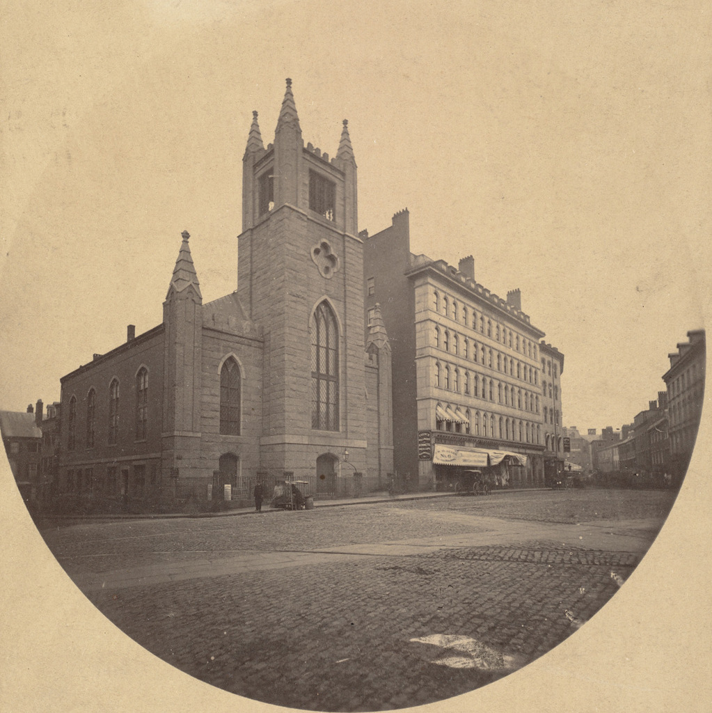
Boston and Providence Depot, Boston

The Boston and Providence Depot at Park Square in Boston, around 1860. Image courtesy of the Boston Public Library.

815_1860c bpl

The station around 1885. Image courtesy of the Boston Public Library.

815_1885c bpl

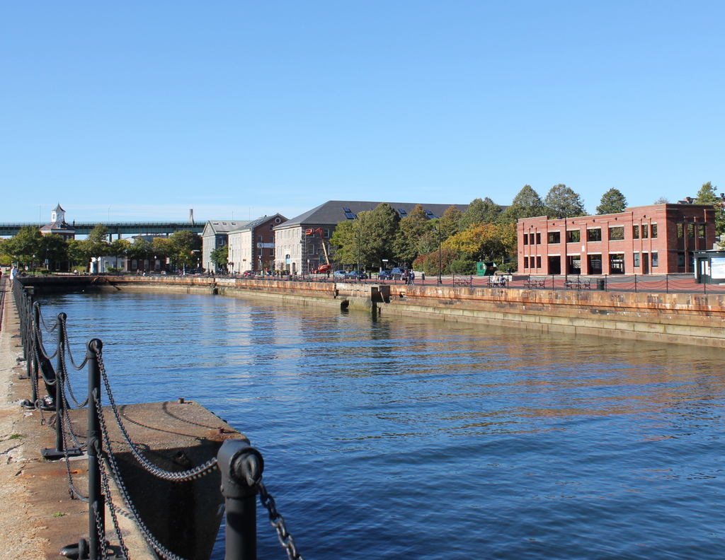
The scene in 2015:

815_2015

The Boston and Providence Railroad opened in 1835, at a time when Boston was still a peninsula connected to the mainland by a narrow isthmus. To avoid taking up scarce land, the railroad built a long trestle across the Back Bay, which at the time was a tidal marsh between Boston and Roxbury. The railroad terminal was built here at the edge of the water, at what eventually became Park Square.

The original station from the first photograph was demolished in the early 1870s so that the city could build Columbus Avenue, and it was replaced with the much larger station in the second photograph. In advertisements, it was hailed as “The Palace Depot of the World,” and from here passengers could board a train for Providence, New York, and other points south. However, by the late 19th century there were eight different railroads serving Boston, each of which operated its own separate station. The four railroads on the north side all had terminals near where North Station would be be built in 1893, and three of the south side terminals were located in the immediate vicinity of today’s South Station. The Providence and Worcester depot was the one outlier; it was on the south side, but it was a half mile away from the next closest station.

Because the multiple stations were both inconvenient for passengers and a waste of valuable property, the four south side railroads finally consolidated into South Station in 1899. This station and the tracks leading to it were closed, and the railroad, which by then had been leased to the New York, New Haven and Hartford, was rerouted onto new tracks, parallel to the Boston & Albany Railroad.

Today, none of the buildings from the first two photos are still standing. The site of the station is now the Boston Park Plaza Hotel, which was built in 1927 as the Hotel Statler Boston in the triangular block between Columbus Avenue, Park Plaza, and Arlington Street. The only visible remnant from the first photo is the Emancipation Memorial statue, which was added to Park Square in 1879 and can be seen on the far left of both photos.


Old MIT Campus, Boston

The former Massachusetts Institute of Technology campus, looking west on Boylston Street from near Berkeley Street in Boston, around 1890-1901. Image courtesy of the Library of Congress, Detroit Publishing Company Collection.

808_1890-1901c loc

The scene in 2015:

808_2015
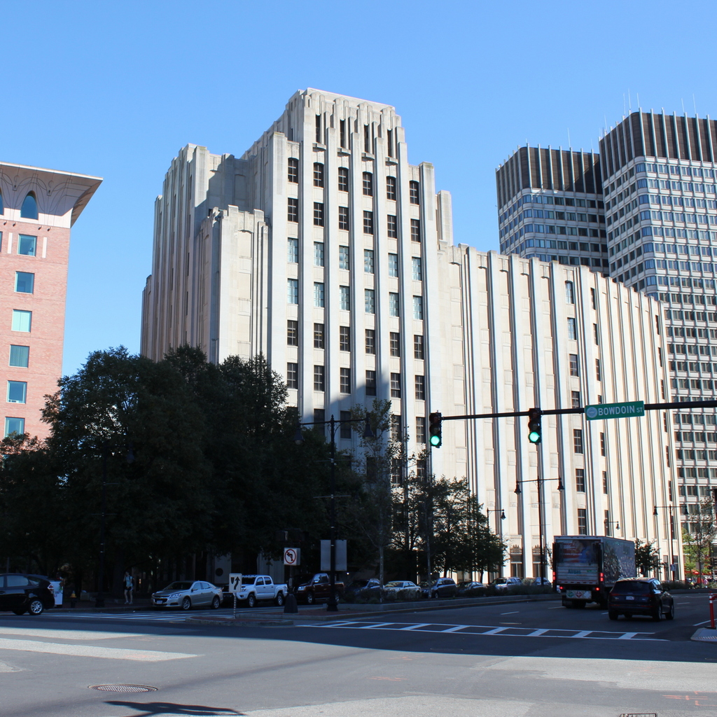
The first permanent home for Massachusetts Institute of Technology was in this building in the foreground. Completed in 1866 and later named the Rogers Building in honor of the school’s founder, it matched the architectural style of the adjacent Museum of Natural History, which is still standing today just to the right of here. The school was established to fill a need for a college education that focused on modern developments in science and technology, and despite some initial challenges such as the Civil War in the 1860s and an economic recession in the 1870s, the school began to grow. In 1883, the campus expanded with the Walker Building, which can be seen to the left in the first photo, at the corner of Clarendon Street. Even this was not enough, though; from 1881 to 1897 enrollment nearly quadrupled, and by the early 1900s the school was spread out across 10 buildings in the Copley Square area.

In 1916, most of the school moved to a new campus across the river in Cambridge, although the Rogers Building was retained as the home of the School of Architecture until the 1930s, when it was sold to the New England Mutual Life Insurance Company. Both the Rogers and Walker Buildings were demolished in 1939, and the insurance company built their new headquarters here, as seen in the 2015 photo. New England mutual merged with Met Life in 1995, and today their former headquarters is mixed-use building with retail and office tenants.

Hotel Aspinwall, Lenox, Mass (3)

The west side of the Hotel Aspinwall, around 1902-1920. Image courtesy of the Library of Congress, Detroit Publishing Company Collection.

798_1900-1920 loc

The scene in 2015:

798_2015
This view shows the opposite side of the hotel from the photos in the previous posts, and this post gives more details on the history of this hotel, which stood here from 1902 to 1931, when it was destroyed in a fire. The fire was believed to have started on the veranda on this side of the building, and although the exact cause was never determined, contemporary newspaper reports indicate that it was probably from a carelessly discarded cigarette.

The site of the hotel is now Kennedy Park, which has hiking and cross country skiing trails and several scenic overlooks, including this one. In the foreground is the Kennedy Park Belvedere, which was built in 2011 in memory of Dr. Jordan Fieldman, a physician at Berkshire Medical Center who died of cancer in 2006. It became the subject of controversy, though, when a group of local citizens objected to it and filed lawsuit against the town. The suit was ultimately dismissed, and the memorial is still here, in approximately the same location where guests such as Theodore Roosevelt, Franklin Roosevelt, and John D. Rockefeller, Sr. once enjoyed the view from the hotel’s veranda.

Hotel Aspinwall, Lenox, Mass (2)

Another view of the east side of the Hotel Aspinwall, around 1905-1915. Image courtesy of the Library of Congress, Detroit Publishing Company Collection.

797_1905-1915 loc

The scene in 2015:

797_2015
This scene shows the main entrance to the Hotel Aspinwall, where its many distinguished guests would have arrived. The previous post, which provides more details about the hotel’s history and destruction, shows the building from the same side, just facing the opposite direction. The site of the hotel has been undeveloped since it burned down in 1931, and today the property is Kennedy Park, a public park owned by the town of Lenox.

Hotel Aspinwall, Lenox, Mass (1)

The east side of the Hotel Aspinwall, as seen around 1905-1915. Image courtesy of the Library of Congress, Detroit Publishing Company Collection.

796_1905-1915 loc

The scene in 2015:

796_2015
As mentioned in the post featuring the hotel’s entrance, the Hotel Aspinwall was built in 1902 by lawyer, businessman, and Civil War officer Thomas H. Hubbard. It was located on over 400 acres of land atop a hill just north of the center of Lenox, and with 225 guest rooms accommodating up to 425 people, it was among the largest hotels in the Berkshires.

The hotel attracted a number of notable guests over the years. As the Berkshire Eagle described it in a 1956 feature article, “If the millionaires who used to summer in Lenox during the early 20th century were not among those owning estates here, they probably stayed at the old Aspinwall Hotel.” The article identified guests such as Theodore Roosevelt, Franklin D. Roosevelt, actress Lillian Russell, Senator and railroad magnate Chauncey Depew, Massachusetts governor James Michael Curley, New York mayor Seth Low, and Austro-Hungarian ambassador Konstantin Dumba. Another news article, published in the North Adams Transcript, indicated that John D. Rockefeller, Sr. was also a frequent guest at the hotel.

By the early 1930s, America was in the midst of the Great Depression, and many historic grand hotels were struggling. However, here in Lenox, the Hotel Aspinwall was expanding. They had recently added a baseball field and a 9-hole golf course, and they were working on adding more trails and bridle paths on the property when a fire started early in the morning on April 25, 1931. The hotel had not yet opened for the season, but the secluded location was reportedly popular for “petting parties,” as contemporary newspapers described it. The exact source of the fire was never identified, but most likely theory seems to be that it was started with a carelessly disposed cigarette from one of these parties.

The fire was already well underway by the time the fire department learned of it, and at that point there was no way to save it. The hotel’s own firefighting systems had been shut down for the winter, and the closest fire hydrant was nearly a mile away. There was not enough water pressure in the 4,000-foot hose from the hydrant to effectively fight the fire, so most of the firefighting efforts were on preventing the fire from spreading to the other buildings or to the forest.

The rest of the property was saved from the fire, but the hotel was never rebuilt, and the forest soon began to reclaim the property. In 1956, the land was sold to the town for just $12,000 and converted into a public park. Now known as Kennedy Park, the hotel’s former driveway and trails are now used by hikers and cross country skiers, and there is little sign of the hotel that once stood here. Based on maps that showed the hotel, this clearing appears to be approximately the center of the building, although without any identifiable landmarks left from the first photo, it is impossible to recreate the exact spot.