Central Congregational Church, Worcester, Mass

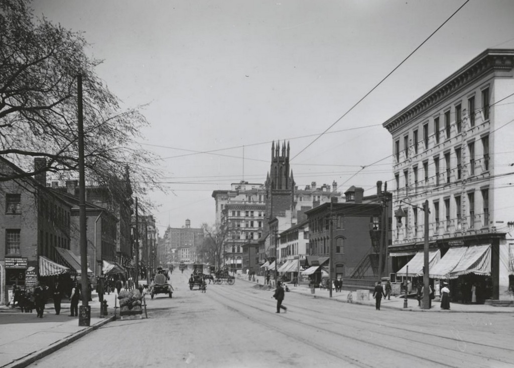
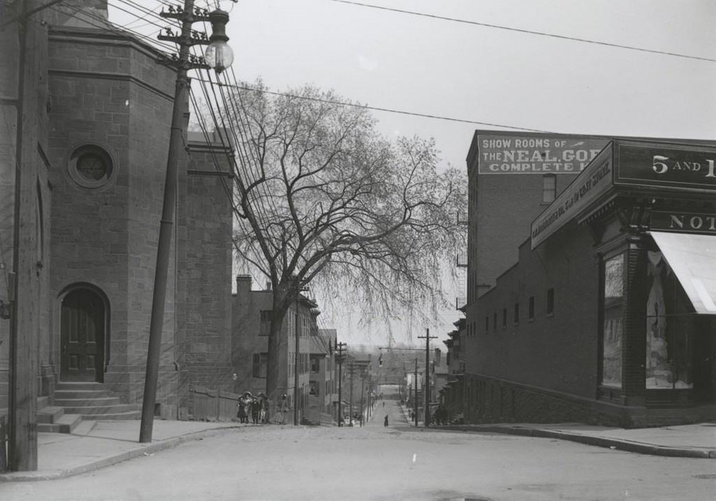
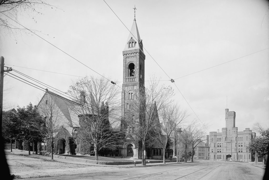
Central Congregational Church, at the corner of Grove Street and Institute Road in Worcester, around 1906. Image courtesy of the Library of Congress, Detroit Publishing Company Collection.
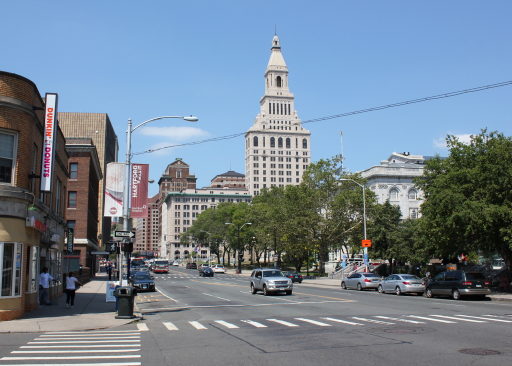
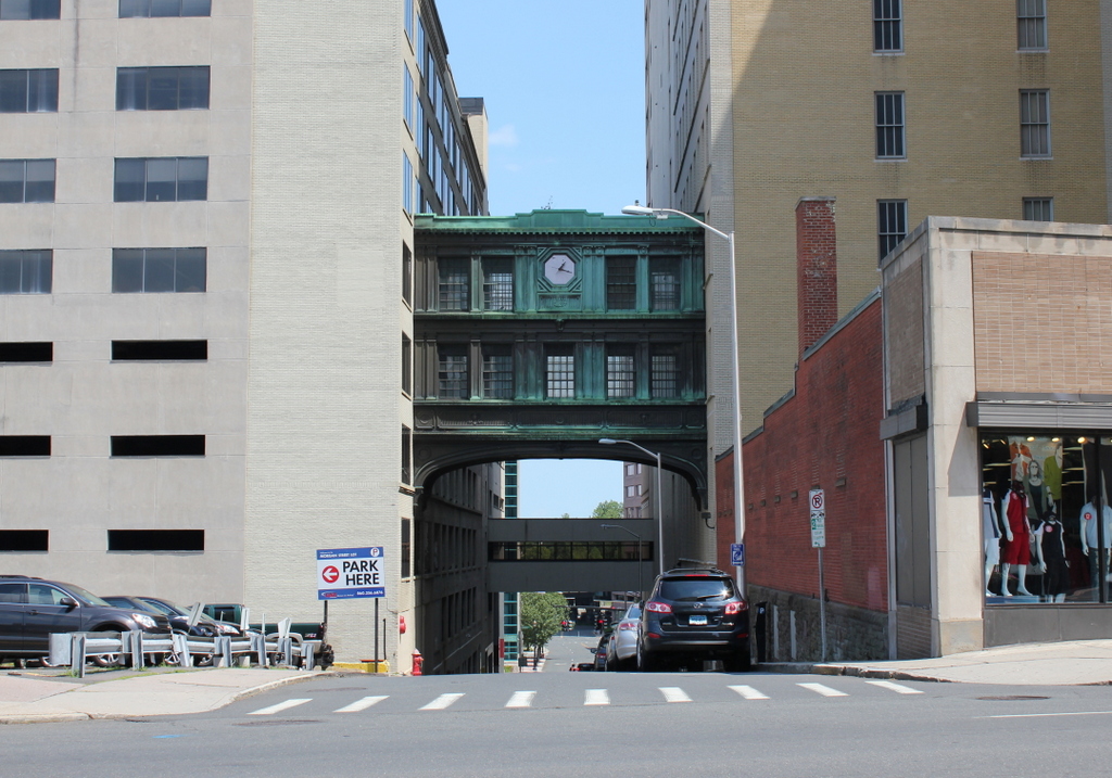
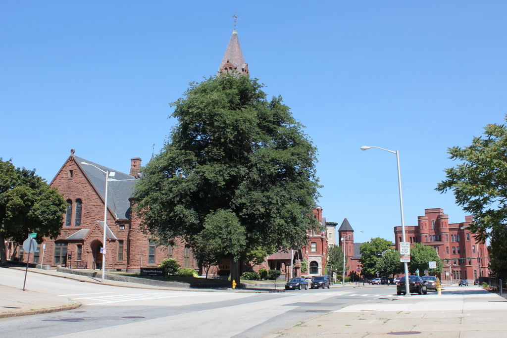
1013_1906c-loc

The scene in 2016:

1013_2016

This church is one of many historic Romanesque style buildings in the city of Worcester, and like many of the others it was designed by Stephen C. Earle, a local architect who designed public buildings in Worcester and across New England. The church congregation that occupied this building was originally established in 1820, but as the city grew in the second half of the 19th century, they sought to move out of the rapidly developing commercial center.

Located just north of downtown at Wheaton Square, construction of the church began in 1884, and was completed the following year. Its design included many elements that were found in Romanesque churches of the era. Its exterior walls were made of Longmeadow brownstone, and it had an asymmetrical design that included a tower plus smaller turrets, along with plenty of arches and stained glass windows. Further down Grove Street in the first photo is the Worcester National Guard Armory. This castle-like building was completed a few years after the church, and it similarly features Romanesque architecture. Also visible in the distance are two other historic Romanesque buildings of the same era. Just beyond the church, near the corner of Grove and Salisbury Streets, is the 1891 Worcester Historical Society building, and just to the left of the Armory is the 1889 North High School.

Today, all four of these late 19th century buildings are still standing here at Wheaton Square, and aside from the tree partially blocking the view of the church, almost nothing has changed in this scene over the past 110 years. Because of this, all four are listed as contributing properties in the Institutional District, a historic district on the National Register of Historic Places that encompasses much of the surrounding neighborhood.

Main Street from Sheldon Street, Hartford, Connecticut

Looking north on Main Street from Sheldon Street, around 1903-1906. Image courtesy of the Connecticut State Library.

Main St. south of Arch

Main Street in 2016:

1012_2016
When the first photo was taken, this section of Main Street just south of downtown Hartford was still an assortment of low-rise brick commercial buildings, most of which probably dated back to the mid 19th century. However, this would soon change. Already, larger buildings were rising in the distance, including the Travelers Insurance building, partially visible in the distant center of the first photo. Also building around the same time was the Wadsworth Atheneum, hidden from view at this angle but located on the right side of Main Street. This museum opened in 1844, but by the turn of the century they were looking to expand their building.

At the same time that these buildings were being built, though, others were coming down. The first photo was taken shortly before St. John’s Episcopal Church, seen in the right center of the photo, was demolished to make way for the Atheneum expansion. The commercial buildings further to the right would soon disappear, too. By 1915 they would be demolished to build the Municipal Building, located at the corner of Main and Arch Streets.

Today, not much is left from the first photo. The Atheneum is still there, and is partially visible behind the trees, and the only other surviving landmark is the Travelers Insurance building, which was greatly expanded in 1919 to include the tower in the center of the 2016 scene. The only other prominent historic building in this scene is the Municipal Building, which was completed about 10 years after the first photo was taken and still functions as Hartford’s city hall a century later.

Sheldon Street from Main Street, Hartford, Connecticut

Looking east on Sheldon Street from Main Street, on April 18, 1906. Image courtesy of the Connecticut State Library.

Sheldon St. east of Main

Sheldon Street in 2016:

1011_2016
Located in the southern part of downtown Hartford, Sheldon Street has undergone some significant changes in the past century. Most of the buildings from the first photo are late 19th century brick commercial buildings, and none of them are still standing today. Most would have been gone by the 1950s, when two major public buildings were constructed on either side of the street. On the left is the Hartford Public Library, which was built in 1957 and extensively renovated in 2007, and on the right is the Abraham A. Ribicoff Federal Building, which was completed in 1963 and houses the U.S. District Court along with other federal offices.

Morgan Street from Main Street, Hartford, Connecticut

Looking east on Morgan Street from Main Street, on April 22, 1906. Image courtesy of the Connecticut State Library.

Morgan St. east of Main

Morgan Street in 2016:

1004_2016
These photos show the same scene as the ones in this earlier post, just from the opposite direction, facing down the hill toward Market Street. When the first photo was taken, this section of Main Street was somewhat on the northern edge of the downtown area, as shown by the signs here in the storefronts. Instead of the prominent department stores, banks, and insurance companies a few block south of here, this area had businesses like a wallpaper store and a grocery store.

Over a century later, this spot has become an even more stark dividing line between the downtown central business district and the northern part of the city, with Interstate 84 now passing through the left side of the scene, and the interchange with Interstate 91 in the distance. On the right side of the photo is a parking garage, which was once part of the G. Fox department store complex here. Like most of the other photos that William H. Thompson took in the early 20th century, there are no buildings left from the first photo, although the Bulkeley Bridge, which was under construction in the distance at the time, is still standing at the eastern end of Morgan Street.

Talcott Street from Main Street, Hartford, Connecticut

Looking east on Talcott Street from Main Street, on April 22, 1906. Image courtesy of the Connecticut State Library.

Talcott St. east of Main

Talcott Street in 2016:

1003_2016
This first photo was taken just a block away from and on the same day as the one in the previous post, and it shows Talcott Street facing down the hill toward Market Street, where a photo in another earlier post was taken. As mentioned in that post, the buildings that dominate the present-day scene were originally the home of the Hartford-based G. Fox department store. The company was located here when the first photo was taken, in a much smaller building just out of view to the right. The one-story building on the right side of the first photo was a Woolworth store, and on the left side was the North Baptist Church.

Just over 10 years after the first photo was taken, the G. Fox building burned down, along with the neighboring Woolworth building. Based on the photos here, it appears that the section of the building along the Talcott Street side was preserved and incorporated into a new Woolworth building, but G. Fox completely rebuilt, opening the present-day building in 1918. The facility was later expanded to include a warehouse on the left side of Talcott Street and a bridge connecting the two buildings. At some point, the North Baptist Church building was also demolished, and is now a parking lot.

As for G. Fox, the company was a major Hartford retailer for nearly 150 years, before closing in 1993. Their former building here has since been converted into the Capital Community College, and it is listed on the National Register of Historic Places, as one of several historic department store buildings still standing in downtown Hartford.

Temple Street from Main Street, Hartford, Connecticut

Looking east on Temple Street from Main Street, on April 22, 1906. Image courtesy of the Connecticut State Library.

Temple St. east of Main

Temple Street in 2016:

1002_2016
Of all the street views that photographer William H. Thompson took in downtown Hartford during the early 20th century, there are very few buildings that survive today. One of the few is the Cheney Building, seen on the left here at the northeast corner of Main and Temple Streets. Only a small portion of this massive building is visible here, but it clearly shows the Romanesque details of the building, which was designed by prominent architect Henry Hobson Richardson. Although better known for grand public buildings such as churches, city halls, libraries, and railroad stations, he also designed some commercial buildings, including this one here, which was completed in 1876.

For many years, the Cheney Building was home to the Brown Thomson department store, and was one of several department stores along this section of Main Street. The company was later purchased by G. Fox, whose flagship store was directly adjacent to the building. G. Fox expanded into the Cheney Building, and remained here until the company closed in 1993. Today, although all of the 19th century buildings around it are long gone, the Cheney Building has been restored, and is now a Marriott hotel, with stores and restaurants on the ground floor.